


 text new page (beta)
 English (pdf)
 Article in xml format
 Article references
 Send this article by e-mail
 Cited by SciELO
  Similars in
SciELO
Similars in
SciELO 
 Permalink
Introduction
Investigation of historical large earthquakes is one of the most important seismological issues for understanding the long-term active tectonics within the context of earthquake hazard assessment. In addition, the quantification of the ground motions resulting from such strong earthquakes, where their recordings are not available, represents a necessary approach for earthquake engineering purposes (e.g. Honoré et al., 2011).
Numerous well-documented, large historical earthquakes have occurred in northwestern Syria, that originated in the Dead Sea fault system (DSFS) (e.g. Sbeinati et al., 2005). Among those past events is the earthquake of 13 August 1822, which occurred in northwestern Syria and the neighboring provinces in central-southern Turkey. This earthquake was descriptively and analytically included in numerous earthquake catalogues. The worldwide descriptive catalogue of R. Mallet and J.W. Mallet (1858: 140-42, 150-51) represents the first report of this earthquake, and some foreshocks and aftershocks, based on data provided by French journals such as the Annales de Chimie et de Physique, Le Moniteur, Journal des Débats and Journal des Voyages. Al-Ghunaim (2002), in his historical descriptive catalogue on earthquakes in the Arab countries, provided all Arabic accounts of the 1822 earthquake without giving his own interpretation for this earthquake. The last catalogue that listed this event is the historical parametric one compiled by Sbeinati et al. (2005) that presented damage in 29 localities, based on the work of Ambraseys (1989), the famous Aleppian historian Mohammad Ragheb Al-Tabbakh (Al-Tabbakh, 1925: 400-410), and the letter of the French consul in Aleppo Monsieur "Mathieu-Maximilien-Prosper de Lesseps- (1771-1832), dated on September 1822 (Archives des Affaires Étrangères, 1822, 176-181). Ambraseys is the first to provide an extensive description of the earthquake of 57 localities affected by this earthquake in Syria, Turkey, Cyprus and Lebanon, based on the numerous consular archives, contemporary accounts, and press reports (Ambraseys, 1989; 2009). He later reassessed the epicentral coordinates and the surface-wave magnitude (Ambraseys and Jackson, 1998). Table 1 lists a summary of the results of some previous works. Ambraseys (1989; 2009) emphasized that more work is required to fully understand this large earthquake and other similar events that struck the plate boundary between the Arabian and the Anatolian plates.
Table 1 Parameters of the 13 August 1822 earthquake according to the previous works. Abbreviations: Ms: surface-wave magnitude; Io: epicentral maximum intensity; IA: intensity at Aleppo city. 1822Am, 1822AmJ and 1822Sb are the symbols of epicenter shown in Figure 3.
| Author(s) | Epicenter (Lat.-Long.) | Symbols on Fig. 3 | Depth (h) | Ms | Io (Scale) | IA |
|---|---|---|---|---|---|---|
| Ambraseys(1989) | 36.70-36.90 | 1822Am | - | 7.4 + | X (MSK) | VII-VIII |
| Ambraseys & Jackson (1998) | 36.70-36.50 | 1822AmJ | - | 7.5 | - | - |
| Sbeinati et al. (2005) | 36.10-36.75 | 1822Sb | 18 | 7.0 | IX (EMS-92) | VIII-IX |
Recently, some preliminary results on the 1822 earthquake were presented by Darawcheh et al. (2019). In this paper, we return to the 1822 earthquake since numerous new and relevant original and contemporary sources of information have been found. Accordingly, the purpose of this paper is to: (1) resume the analysis of the new historical sources of the 1822 earthquake; (2) assess its new parameters in light of these new sources; (3) suggest the most probable causative fault of the earthquake. Also, it aims to produce ground motion simulation of the earthquake using the stochastic finite-fault method for a historical site in the damaged area. It is believed that the results of the paper represent additional contributions to the 1822 earthquake, not mentioned at the previous works.
Pachalic of Aleppo
The earthquake of 1822 occurred during the Ottoman period in Syria. Aleppo (in Arabic Halab) was the capital of the state called the Pachalic of Aleppo (Pachalic is a province governed by a Pasha or Governor-General). According to the French orientalist Constantin-Françios Volney (1757-1820), who stayed in Aleppo from 1783 to 1784, the Pachalic extended from the Euphrates river to the Mediterranean Sea, between two imaginary lines; one drawn from the town of Iskenderun to the small town of Birecik; the other from the village of Balis to the Mediterranean Sea, by both towns of Maarrat Al-Nu’man and Jisr Al-Shughur (Figure 1). Administratively, this province includes numerous small towns such as Antioch (in Arabic Antakia), Iskenderun, Aintab, Idlib, Jisr Al-Shughur, Suwaydiyeh and Payas along with more than 3000 villages (Volney, 1788: 139).
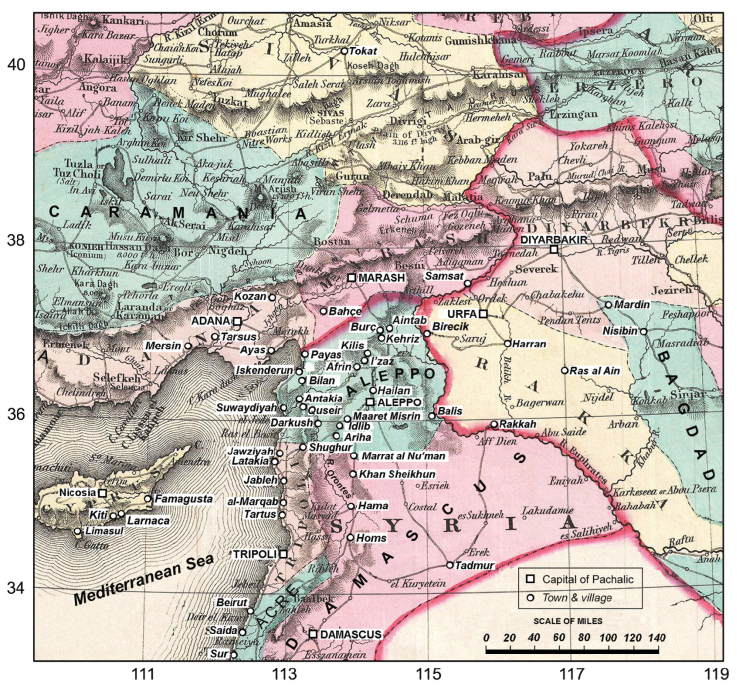
Figure 1 A geographical map of the Pachalics of the Ottoman Empire in and around Syria showing the location of Pachalic of Aleppo (modified after Colton, 1855:25).
Aleppo was the third largest city in the Ottoman Empire, in size and population, after Constantinople (now Istanbul) and Cairo. This city was one of the best built in the whole Ottoman Empire. Most of the houses are one-story built of hewn stone and there were numerous mosques; the Great Umayyad Mosque is the most important one. Aleppo has nine historical gates and is surrounded by a thick ancient wall built in the Mamlouk period. One of the more remarkable structures in the city is the medieval citadel, built after 1209 AD. (Talas, 1956). It has an elliptical shape and is built on a natural high hill. The city had many large squares, two-story khans (commercial courtyard buildings) and roofed long bazaars (market places). The river Quaiq that rises near Aintab runs west-ward of the city. The city was a large commercial center of the Levant and an important center of economic, cultural and political activities to the extent that many chroniclers, scholars, orientalists and travelers visited and lived here (Russell, 1794: 1-40; Conder, 1824: 274-297). In addition, many European states opened consulates and trading offices in Aleppo during the 16th and 17th centuries such as the consulates of Republic of Venice, France, England and the Dutch.
Most of the historical sources indicate that the population of Aleppo and its suburbs was about 200,000 at the beginning of the 19th century, including 20,000 Christians and several thousand Jews. Miller (1826: 22) mentioned that Aleppo had 40.000 houses. Figure 2 is a plan of Aleppo during the period 1811-1818. Although it contains inaccuracies and errors (e.g. direction of the citadel), the map has a large historical value as it includes the gates of Aleppo, quarters within the wall, suburbs, small gates of suburbs, and significant buildings along with public establishments, gardens and cemeteries.

Figure 2 Plan of Aleppo city and its environs prepared during the period 1811-1818. The plan first established in 1811 by Vincent Germain, a European resident in Aleppo who was in the consul of France, then completed in 1818 by Jean-Baptist Rousseau (1780-1831), the French consul of Aleppo in 1814 (Raymond, 2010). The broken, bold line between the gates represents rests of the wall of the old city. (modified after Barbié du Bocage, 1825: 218-244).
As seen, Aleppo was a famous city in the East and West, and had important economic, cultural, and historical value. Unfortunately, this situation changed completely in few seconds at the night of August 13, 1822.
Tectonic Setting and Seismicity
The 1822 earthquake struck a region located in northwestern Syria and Turkish neighboring areas. In this region, three active faulting systems meet (Figure 3). They are the left-lateral Dead Sea fault (DSF), the left-lateral East Anatolian fault (EAF) and Cypriot Arc (CA), in which the Latakia fault (LAF) is the southern segment of the CA. The DSF represents a plate boundary between the Arabian plate and Sinai subplate, EAF is the plate boundary between Arabian and Anatolian plates, and CA is a wide boundary between Sinai subplate and Anatolian plate. This means there is a triple junction in the region. In this regard, Over et al. (2004), using SPOT imagery and seismicity data, defined the point of triple junction to the NE of Antakia in the Amik basin (so-called Antakia or Amik triple junction, ATJ).
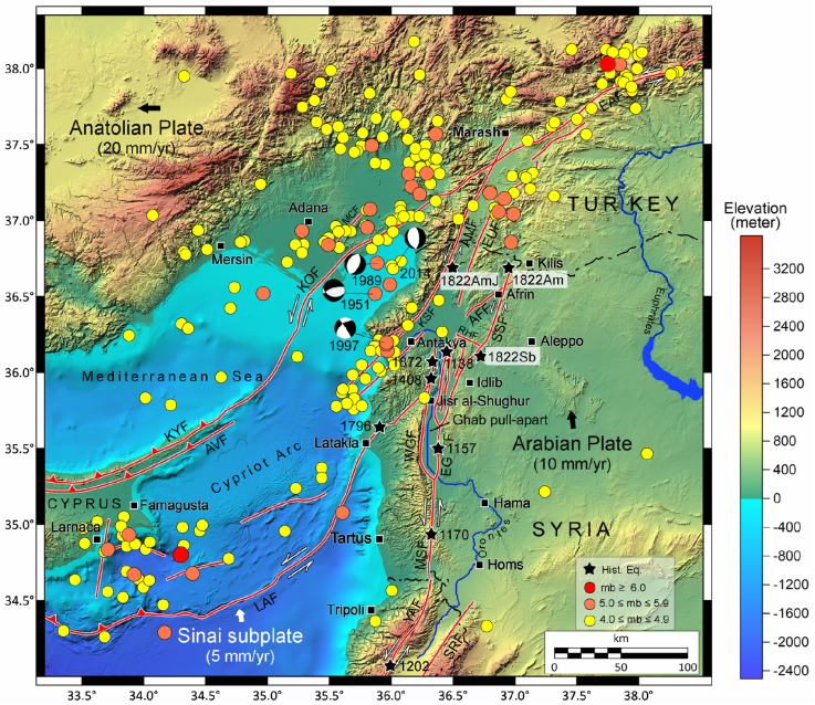
Figure 3 A digital elevation model of the northwestern of the Mediterranean showing the main faults (red lines), the distribution of instrumental seismicity (mb≥4.0) during the period 1900-2017 (different color circles), and the main historical earthquakes (black stars). The epicenters of the 1822 earthquake of previous studies are symbolized according to Table 1. Faults are from Över et al. (2002), Karakhanian et al. (2008), Tari et al. (2013). Instrumental earthquake data are compiled from ISC. Abbreviations of the faults: AFF: Afrin fault; AMF: Amanus fault; EAF: Eastern Anatolian fault; EGF: East Ghab fault; HPF: Hacipaşa fault; KOF: Karataş-Osmaniye fault; LAF: Latakia fault; KSF: Karasu fault; MCF: Misis-Ceyhan fault; RHF: ar-Rayhaniyah fault; SSF: Saint Simeon fault; WGF: West Ghab fault. Large black arrows present relative plate motions after (Jackson and McKenzie, 1988; McClusky et al., 2000).
Numerous faults exist to the west of Aleppo within the ATJ. The 145-km-long Amanus (Karasu) fault (AMF) has a NNE-SSW orientation. AMF may be part of the EAF (Westaway, 1994). The 114-km-long Saint Simeon fault (SSF) stretches from the northeastern corner of Ghab pull-apart basin in NNE-SSW direction. Karakhanian et al. (2008) demonstrated that SSF is an active fault according to the observed left-lateral displacements and deformations of the landforms. North of Afrin, the 40-km-long Afrin fault (AFF) joins the SSF. No information is available for AFF. Between Jisr ash-Shughur and Antakia, the active NS Hacipaşa fault (HPF) exists, which belongs to the northern DSF (Akyuz et al., 2006).
Instrumental seismicity from 1900 is low to moderate (Figure 3). Focal depths are in the range of 5-15 km. As shown in Figure 3, the earthquake activity for ≥ 4.0 (mb) is mainly distributed along EAF, the extension of AMF at sea, and along the Karataş-Osmaniye fault (KOF). Although the instrumental seismicity reveals only small to moderate earthquakes, the region has been the site of numerous large historical earthquakes that damaged Aleppo, Antakia, Latakia and other towns, like the 10 October 1138, 29 December 1408, 26 April 1796, 13 August 1822 and 3 April 1872 (Ambraseys, 1989; Ambraseys, 2004; Guidoboni et al., 2004; Sbeinati et al. 2005). Consequently, this may indicate that the current seismic activity may be going through relative quiescence, compared with the historical earthquakes (Abdul-Wahed and Asfahani, 2018).
Data and Methodology
Historical Sources of Information
In this paper, thirteen new contemporary and near-contemporary sources of information cited partly or not cited in the works of Ambraseys (1989) and Sbeinati et al. (2005) are presented. These new sources, listed in Table 2, enabled us to describe in more details the seismic damage in Aleppo, Antakia and Latakia, and to identify new affected localities. These new sources include local accounts written by Aleppians; British and French consular correspondences from Aleppo and Latakia in Syria and Kiti in Cyprus; Letters written by visitors; accounts left by travelers; diaries and accounts written in European magazines and journals. Also, other historical sources that include very short accounts of aftershocks of the main 1822 earthquake were considered and used.
Table 2 A list of the new historical sources for the earthquake of 1822.
| Source of information | Type of document/date (language) | Main localities mentioned | Reference(s) |
|---|---|---|---|
| Paul Aroutine, bishop | Manuscript (Arabic) | Aleppo | Aroutine (1933) |
|
|
|
Aleppo | Taoutel (1958) |
| Mohammad Agha Mekansi, Aleppine centenarian | Diaries (Arabic) | Aleppo | Al-Ghazzi (1926) |
| Benjamin Barker, brother of the British Consul in Aleppo | Letter/23 Aug. 1822 (English) | Aleppo | The Religious Tract Society (1822); Conder (1824) |
| John Barker, British Consul at Aleppo | Account/13 Sept. 1822 (English) | Aleppo, sea waves between Cypriot and Syrian coasts | The Edinburgh Magazine (1823) |
| Joseph Wolf, Missionary and oriental scholar | Traveler account/diary (English) | Jawziyah, Latakia | The Missionary Journal (1824) |
| Anonymous English gentleman | Diaries (English) | Antakya, sea waves in Suwaydiyeh | Neale (1854) |
| Anonymous | Account (English) | Aleppo, Latakia, Jableh | Miller (1826) |
| Austrian Observer | Letter/ 3 Sept. 1822 (English) | Aleppo, Antioch, Latakia, sea near Cyprus | The Asiatic Journal (1822) |
| Monsieur Derché, second dragoman of the French Consulate in Aleppo | Document/14 Aug. 1822 (French) | Aleppo | Derché (1824) |
| Charles-Édouard Guys Vice-Consul of France in Latakia | document of archive/15 Oct. 1822 (French) | Latakia, Jableh, al-Markab | Bulletin de la Société de Géographie (1822) |
| Observatoire Autrichien | Account/1822 (French) | Aftershocks at Aleppo | Gazette Géographique (1822) |
| Anonymous | Annals (French) | Aleppo | Gay-Lussac and Arago (1822) |
Historical Earthquake Methodology
For re-assessing the 1822 earthquake, the procedures recommended by the International Atomic Energy Agency (IAEA, 1987) were considered. These procedures concern the methodology of the historical earthquake search, how to study these data, and how to extract and assess the parameters of historical earthquakes.
These new sources (Table 2) were studied to re-assess the 1822 earthquake and its effects. Also, some secondary sources and studies dealing with this earthquake were considered. We estimated the macroseismic intensity using the European Macroseismic scale, EMS-98 (Grünthal, 1998). In addition, some focal parameters of the earthquake were estimated based on the empirical relationships of Ambraseys and Jackson (1998). The surface-wave magnitude (Ms) of the earthquake was estimated with the empirical relationship, developed by Ambraseys and Jackson (1998), for the Middle East:
where Ri=(ri 2+9.722)0.5 and r (km) is the mean isoseismal radius of intensity I, and p is zero for mean values and one for 84 percentile values. Ms was converted to moment magnitude (MW) using the following empirical relationship developed for Syria (Alissa et al., 2021):
Simulation Method
The stochastic finite-fault method is widely used in ground-motion simulations of past or scenario earthquakes. Here, we use the extended stochastic finite-fault simulation method (EXSIM) proposed by Motazedian and Atkinson (2005).
The EXSIM was developed from both the stochastic point source simulation (SMSIM) proposed by Boore (1983, 2003), and the finite fault simulation (FINSIM) proposed by Beresnev and Atkinson (1997, 1998). Strong ground motion simulation involves a physical approach, using the earthquake source, the path, and the site effects. The stochastic point source model assumes the source process is concentrated at a single point and the acceleration time series generated at a site carries both deterministic and stochastic aspects of ground motion. The deterministic part, which is a function of both magnitude and distance, is specified by Fourier amplitude spectrum, and the stochastic aspects are obtained by treating the motion as white noise. Beresnev and Atkison (1997) extended the stochastic procedure to large faults by subdividing the large fault into sub-faults, each of which is then treated as a point source. The ground motions at a site is obtained by summing the contributions of all sub-faults. Motazedian and Atkinson (2005) introduced the concept of dynamic corner frequency to reduce the dependence on sub source size.
In this study, the latest version of extended stochastic finite-fault simulation code EXSIM12 (Atkinson and Assatourians, 2015) is employed to simulate the ground motion of the 1822 earthquake at the citadel of Aleppo. This prominent archaeological structure is chosen since it was built on a rocky hill and was damaged by the 1822 earthquake. The ground motion records have been simulated with ten trials to eliminate the bias resulting from stochastic variability.
Results
The Earthquake of 13 August 1822
It should be mentioned that the previous devastating earthquake prior to the 1822 earthquake that destroyed Aleppo was on 11 October 1138. This suggests 684 years of no other major earthquakes until the 1822 earthquake occurred.
The 1822 earthquake was preceded by several foreshocks in a short period (some days). The main event was followed by aftershocks lasting for months. A series of small foreshocks lasted about 7 days. They were felt in Pachalic of Aleppo. The last foreshock happened on 13 August 1822 (at 8 pm local time), half an hour before the main destructive event. This last foreshock event caused great fear in Aleppo. However, no one was able to leave the city because its gates were closed at that moment. This main earthquake took place during a hot summer evening when the people were sitting on the roofs or in courtyards of their houses. This earthquake affected mainly most of Pachalic of Aleppo, the northern part of Tripoli Pachalic, and some parts of Marash Pachalic (see Figure 1 for location). It should be mentioned that four aftershocks occurred one hour following the main event.
In Aleppo, the main earthquake caused large damage and great loss of life. What follows is a summary of the main testimonies of the personalities for the horrible scenes of the earthquake in the city: i) Mohammad Agha Makansi (ca. 1787-1891), an Aleppine centenarian (Al-Ghazzi, 1926: 330-334); ii) Paul Aroutine (1788-1850), bishop of Aleppo (Aroutine, 1933: 77-78); iii) Benjamin Barker, brother of the British consul in Aleppo, John Barker (1771-1831) (Religious Tract Society, 1822), and iv) Monsieur Derché, the second dragoman of the French consulate in Aleppo (Derché, 1824 : 162-168). These four eyewitnesses, who miraculously survived the earthquake, saw tragic scenes in Aleppo such as women without headgear screaming and beating on their chest, laments of the people, death corpses and wounded in the streets, considerable number of inhabitants buried under debris, fallen walls of houses and people rushing toward the neighborhood orchards around the city. Many people tried to recover their death, including their children who were under debris. The fallen houses and buildings produced a cloud of dust that covered the city. After a short time from the main shock, another strong shock completed the destruction in the city.
At dawn of the next day, the size of the catastrophe started to be seen. Dead bodies were seen floating on the Quaik river and many structures and tall buildings partially or completely collapsed. Damages concentrated in the quarters of Bahsita (NW of the old city), Al-Aqaba (west of Aleppo citadel), Al-Farafira (NW of the citadel), Al-Attareen (herbals) souk, towers of the citadel, in addition to most of the houses and buildings located around the citadel (see Figure 2 for locations). The citadel itself along with its great mosque was severely damaged and most of the inhabitants left the citadel and settled in the city below. Also, the ring wall of the citadel, which is composed of towers linked by curtain walls, was damaged. Numerous mosques were severely damaged; the minaret of the Umayyad Mosque (b. circa 713) was split and also Al-Mehmendar mosque (b. 14th century) located north of the Citadel. Due to the strength of the shaking, the crescent of minaret of Al-Othmaniyeh Mosque (b. in 1730), located near Bab Al-Nasr fell to the ground through the southern dome, forming a hole. Also, the dome of the Behramiyeh Mosque (b. 1580) collapsed. The minaret of the Mosque of Al-Kizawani, one of the religious and historical features of Aleppo located in Al-Aqaba quarter, was cut from its middle. Madrassa (school) of Al-Khusruwiyah (b. 1537), located directly west of the citadel, was also damaged. The old Maronite church of Saint Elias (b. ca 15th century) located in the quarter of Al-Jdiadeh was damaged, requiring the Bishop Jromanus Hawa (1752-1827) to send a letter to the British consul on April 16, 1823, complaining on the bad conditions of the parish and asking for help in restoration of the damaged church (Taoutel, 1958: 133-134). Also, Nasrallah Ghazaleh (the clergyman in Aleppo at the time of earthquake), reports that the shaking of the main event caused great fright, to the extent that large number of infants was died. The cathedral of the Dormition was damaged also by the earthquake. The main synagogue located in Al-Aqaba quarter was destroyed. A part of the wall of the old city collapsed on people. The British consulate in Aleppo was completely ruined and the private houses of the European residents were destroyed. Moreover, Khan Al-Hibal (robes) (b. 1594), which was a residence of the French consulate and located, a short distance to the west of Umayyad Mosque, suffered severely without any loss of life. The Austrian general consul in Aleppo, M. Esdra de Picciotti, perished under the debris with 10-12 persons of his family, together with 16 horses, due to the first strong aftershock, these who with him.
The public safety in Aleppo was disturbed due to the earthquake and looting and theft have increased. In this regard, Knost (2010) documented that the Aleppo court was damaged, and its activity interrupted as seen in the court records of the Law Court Registers. Few days later, numerous cases of ophthalmia and dysentery appeared in the city (The Asiatic Journal, 1822: 519). The great number of unburied bodies in this extremely hot period of year produced pestilential effluvia and forced survivors to seek refuge in distant districts. Table 3 presents these aftershocks, and Figure 4 is a time series of the 1822 earthquakes. Therefore, Aleppines remained encamped around the city few months later (The Asiatic Journal (1822: 519) However, these aftershocks seem to continue till 10 October 1824 (The Missionary Herald, 1825: 373). The Asiatic Journal (1822: 519) also mentioned that an immense quantity of valuable goods of all kinds from Persia and India has been destroyed. It is said in Aleppo that a meteor fell near the village of Atarib at the night of August 13, 1822.
Table 3 A list of foreshocks and aftershocks of the 1822 earthquake.
| Date (LT) | Description | City/town | Reference(s) | Intensity (EMS-98) |
|---|---|---|---|---|
| 5 Aug. 1822 | slight shock | felt at Aleppo & Antakia | Ambraseys (1989) | IV |
| 5-12 Aug. | slight shocks | felt at Aleppo & Antakia | Ambraseys (1989) | III-IV |
| 10 Aug. | slight shock | felt at Aleppo | R. Mallet & J.W. Mallet (1858) | IV |
| 12 Aug. | slight shock | felt at Aleppo, Antakia & Latakia | Miller (1826) | IV |
| 13 Aug. (20:10) | strong shock | felt between Latakia, Aleppo & Antakia | Ambraseys (1989) | V |
| 13 Aug. (20:40) | main shock | Northwestern Syria & the nearby areas in southern Turkey | All sources of information mentioned in Table 2 | VIII-IX |
| 13 Aug. (night) | successive damaging shocks | felt at Aleppo, Antakia & Aintab | Ambraseys (1989) | VI |
| 14 Aug. (morning) | great shock | felt at Aleppo | R. Mallet & J.W. Mallet (1858); Aroutine (1933) | VI-VII |
| 15Aug. | destructive shock | felt at Urfa & Aleppo with some damage | Perrin (1822) | VI |
| 16 Aug. | strong shock | felt at Aleppo | Gay-Lussac & Arago (1822); Perrin (1822) | V |
| 20 Aug. | terrible shock | felt at Latakia | Bayford (1824) | VI |
| 23 Aug. | destructive shock | - | Ambraseys (1989) | VI |
| 4 Sept. (sunset) | destructive shock | felt at Aleppo | Aroutine (1933) | IV-V |
| 5 Sept. (night) | numerous shocks, one of them destructive | damages of some tall buildings at Aleppo | Gay-Lussac & Arago (1822); Gazette Géographique (1822); R. Mallet & J.W. Mallet (1858) | VI |
| 13 Aug.- 20 Sept. | 38 felt shocks | felt at Aleppo | Purdy (1832) | III-VI |
| 29 Sept. | several shocks | felt at Aleppo | R. Mallet & J.W. Mallet (1858) | IV |
| 30 Sept. | several shocks, one of them violent | felt at Aleppo | Gazette Géographique (1822); R. Mallet & J.W. Mallet (1858) | IV |
| 31 Sept. (afternoon) | violent shock | felt at Aleppo | Aroutine (1933) | IV |
| 19 Oct. | violent shock | felt Aleppo | John Barker (Condor, 1824); Purdy (1832) | VI |
| First half of Nov. | strong shocks | felt at Aleppo | Gay-Lussac & Arago (1822); Gazette Géographique (1822); R. Mallet & J.W. Mallet (1858) | IV-V |
| 12 Nov. (night) | very violent shock | felt at Aleppo | R. Mallet & J.W. Mallet (1858) | VI |
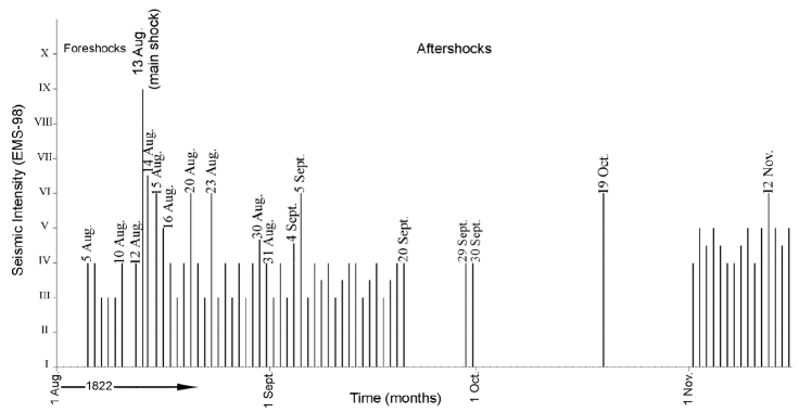
Figure 4 Time series of the most 1822 earthquakes from 5 August 1822 till 15 November 1822 that were felt in and around Aleppo, as documented by the numerous sources of information (last column in Table 3). Each black vertical line indicates a single event.
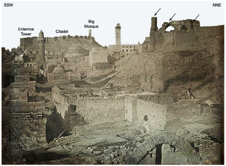
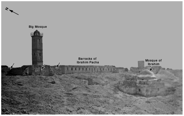
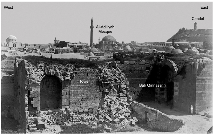
Numerous historical sources mentioned that some ruins in Aleppo due to 1822 earthquake were observable for a long time (Figures 5, 6 and 7). In contrast to the evident destruction in the previous figures, some minarets and towers remained standing. It could be argued that they would be the first to fall during strong shaking. For example, Figure 6 stresses the debris of the barracks of Ibrahim Pacha. However, the minaret of the Big Mosque is unscathed. Figure 7 does show the remains of the tower in the southern gate of the city. Once again, this picture, taken in 1890, 68 years after the Aleppo earthquake, shows a very slim minaret of the Al-Adiliyah mosque. There is no evidence that these apparently sensible constructions withstood the 1822 earthquake or whether they were later reconstructed. But it is likely that they were rebuilt since they were religious places that benefitted from donations of benefactors. The earthquake formed a real phobia for the Aleppines to the extent that from time to time rumors appear of the imminent occurrence of a major earthquake, causing people to panic, leaving their houses and fleeing to the nearby orchards (Bakhkhash, 1985: 16).
Source: Metropolitan Museum of Art at: https://www.metmuseum.org/art/collection/search/726483
Figure 5 The earliest known photograph of Aleppo taken in 1844 by the French photographer Joseph-Philibert Girault de Prangey (1804-1892) showing the miserable condition of the city due to the 1822 earthquake (black arrows).
Source: Historical Digital Documentation House in Aleppo:https://www.dig-doc.org/images/photo_gallery/pic_322020124558.jpg
Figure 6 A photo inside the citadel of Aleppo taken in 1895 showing the debris resulted by the 1822 earthquake and the damages of the Great Mosque (black arrows). The debris was still in situ till the beginning of the 20th century.
Source: Historical Digital Documentation House in Aleppo at: https://www.dig-doc.org/images/photo_gallery/pic_36202052727.jpg
Figure 7 A photo of Aleppo dated back to 1890 showing Bab Qinnsarin, one of two southern gates of the city. Note the remains of its tower destroyed by the 1822 earthquake.
Concerning the loss of life in Aleppo, the main earthquake of 13 August happened at night when most people were indoors, and this contributed to large number of deaths. Estimates of the number of deaths in Aleppo city alone vary between 15000 persons (Al-Ghazzi, 1926: 332), to 25,000-30,000 (e.g. Asiatic Journal, 1822: 519). We believe that these numbers may be exaggeration, but it is certain that the number of people killed was at least 10,000. This figure represents a considerable percentage of Aleppo population at that time. On the other hand, there were an equal number of maimed or wounded. In view of the heavy damage in Aleppo due to the 1822 earthquake, the seismic intensity is estimated between VIII and IX on the EMS-98 (See Figure 8).
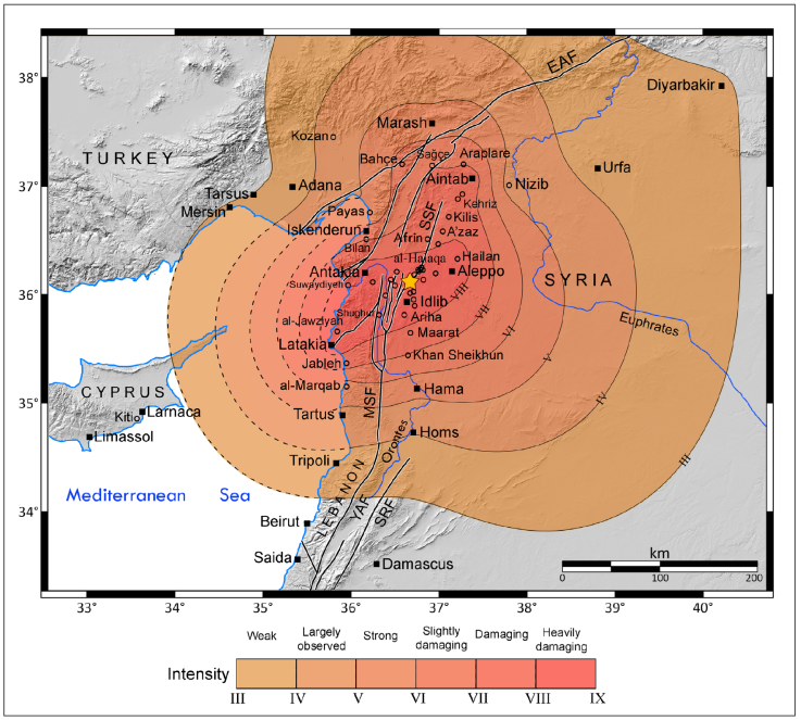
Figure 8 A map showing locations of cities (black squares), towns and villages (empty circles) affected by the 13 August 1822 earthquake. It also shows an averaged isoseismal map for the earthquake. The numbers ranging from III to VIII are intensity degrees on the EMS-98, assessed in this study. The earthquake epicenter is shown with a yellow star. The group of overlapping circles located west of Aleppo are villages of Sahle (plain) al-Halaqa. Abbreviations of the active faults: EAF: East Anatolian fault; MSF: Missyaf fault; SRF: Serghaya fault; SSF: Saint Simeon fault; YAF: Yammouneh fault.
Villages located about 30 km west of Aleppo were damaged, but without any details, such as those located at the plain of Al-Halaqa (Turmanin, Hazra, Dana, Teladeh and Deir Hassan) (Al-Tabbakh, 1925: 407). These last villages are directly located on the St. Simeon fault.
The small town of Idlib, at a distance of 53 km southwest of Aleppo, was entirely ruined. A script documents that its Grand Mosque dated on Mamluk era was repaired after the 1822 earthquake (Fayez Kosara, Historian of Idlib, personnel communication, 2018), a possible indication that this mosque was damaged by the earthquake (See Figure 8). The village of Maaret Misrin located 50 km southwest of Aleppo was destroyed. In this regard, Knost (2010) found in the Law Court Registers in Aleppo that a hammam (bath) and the walls of a farm in this village were damaged.
Antioch, the famous town through the history with about 9,000 to 10,000 inhabitants before the earthquake (Bell, 1832: 194), and located 90 km distance west of Aleppo, was strongly damaged by the earthquake causing a considerable loss of life. It is worth mentioning that Antakia was largely damaged by previous destructive earthquakes, such as the 29 April 1407 (Ambraseys and Melville, 1995). For this town, there is an anonymous English eyewitness who lived in Antakia at the time of 1822 earthquake, and his memories were presented to the English Sir Frederick Arthur Neale (1821-1863) when visited the town 25 years later of the earthquake (Neale, 1854: xxiii-xxxiv). He recalls how Antioch was turned into a miserable state after the earthquake, and that mosques and buildings were destroyed to the extent that the streets were filled with debris. Half of the houses was leveled, and the other half were damaged. In this regard, the Antioch Court records are rich in dozens of documents indicating the demolition of houses, stores and buildings as a result of the earthquake of 1822 (Capar, 2017). The survivors were busy assisting the villagers and rescuing the wounded. The Grand Khan of the town was destroyed, with its camels and beasts under its debris. Along the coast of Suwaydiyah, the sea was largely disturbed and no boat could withstand the sea waves. Some unofficial estimates have mentioned that four to five thousand people perished by the earthquake, representing half of the population of Antioch (Neale, 1854: xxiii-xxxiv; The Edinburgh Magazine, 1823). Pliny Fisk (1792-1825), an American missionary, visited Antakia in late 1824, and saw ruins of walls, houses and mosques due to the 1822 earthquake (Bond, 1828: 390). John Barker, the British consul in Aleppo, was at his country-house near Suwaydiyeh, at the time of the earthquake. He and his wife survived the earthquake and mentions that ground cracks were seen everywhere around the town, and the buildings located on the top of mountains were damaged or destroyed. Based on these effects of the 1822 earthquake in Antakia, the seismic intensity is estimated between VIII and IX on the EMS-98 (See Figure 8).
The town of Salqin, located ~30 km east of Antakia and 80 km from Aleppo was destroyed. In the small town of Armanaz, 60 km southwest of Aleppo, damages were serious. It is to mention that there is now a clear inscription at the southern entrance of the Grand Mosque in Armanaz documenting the date of its reconstruction after the 1822 earthquake (Majd Sari, member of the Syrian Astronomical Association, personnel communication, 25 April 2019). In the village of Darkush, located 32 km SE of Antakia, the castle, collapsed and masses of rocks fell on the village destroying most of its houses.
In 1818, Latakia was a flourishing town along the Syrian coast located 145 km southwest of Aleppo, with a population of about 6,000 and 300 houses together with several large magazines (Purdy, 1832: 255). Latakia also suffered strongly from the 1822 earthquake. Several documented earthquakes caused also destruction during its long history; the 26 April 1796 was the last previous one with 1,500 death (e.g. Ambraseys, 1989). Two contemporary sources of information were eyewitnesses on the destruction of the town due to 1822 earthquake: i) Charles-Édouard Guys (1783-1871), vice-consul of France at Latakia in 1822 (Guys, 1822: 301-305), and ii) Joseph Wolff (1795-1862), the German missionary and orientalist who was in a mission in the region (Bayford, 1824: 325-328). The main event of 13 August 1822 caused heavy damages in the town (Miller, 1826: 23). Half of the town was destroyed, and many houses were damaged. Joseph Wolff mentions that 150 houses were totally destroyed, and several hundred people lost their life. Most people ran from their houses and encamped outside the town for a long time. Some families deserted the town and settled in other nearby regions. It is said that the Maktab (school) collapsed on the children killing all of them. The quarter that includes houses of the European consuls has suffered the most. Charles-Édouard Guys says that the French consulate registered one-third of the town collapsed, nearly 200 deaths, and the ruin of the fortress located at the Marina was damaged. He adds that the Big Mosque, the Custom and the Grand Khan (Khan al-Dukhan or Tobacco), located in the seaport (Scala or Marina), were among the damaged buildings. The English traveler George Robinson, who visited Latakia in 17 April 1831, observed numerous large fissures in the walls of houses, and immense stones displaced in many parts of the town due the 1822 earthquake (Robinson, 1837: 363). Aftershocks were felt in Latakia four to five times a day for 40 days as mentioned by Wolff (Bayford, 1824: 325-328).
Several villages around Latakia were totally destroyed. One of them was al-Jawziyah located 15 km to the northeast of latakia (See Figure 8). It is now called Khirbet, meaning ruin of al-Jawziyah. Joseph Wolff in his way from Antakia to Latakia was again an eyewitness in that night of the total destruction of the houses in the village including the killed women, children and cattle. Also, he felt at the night of 13 August with numerous shocks (Bayford, 1824: 325).
In the small coastal town of Jableh, 20 km southeast of latakia, the news arrived that this town became ruins, but some people could escape from the town and the Grand Mosque, which is called Sultan Ibrahim, was damaged (Guys, 1822: 303). Also, Miller (1826: 24) says that three quarters of the town are destroyed, its harbor chocked up by the ruins of the houses that have been fallen into it and 300 persons have lost their lives.
The Crusader castle of al-Marqab, built in late 12th century and located south of Jableh on the top of a mountain, collapsed by the earthquake (Guys, 1822: 303). Further south, the earthquake was felt in Tartus, Tripoli and Saida (Guys, 1822: 303).
Between Aleppo and Latakia, several towns and villages have been destroyed. One of them was Jisr Al-Shughur, the main town that located on the Orontes river. Here, the Great Mosque (Jamea al-Coprly) was slightly damaged, but details are lacking. In this regard, both French travelers, Joseph Michaud (1767-1839) and Jean Poujoulat (1808-1880) on their way from Latakia to Aleppo found Jisr Al-Shughur was heavily damaged due to the earthquake of 1822 as mentioned in the letter no. 173 dated on June 1831 (Michaud and Poujoulat, 1841: 27). News has come to Latakia that Suwaydiyeh and Iskenderun were totally destroyed. For example, Iskenderun transferred into ruins (Guys, 1822: 303).
The small town of Afrin, 40 km northwest of Aleppo, was particularly affected and many buildings were destroyed (Knost, 2010). Aintab, located in southern Turkey, felt this earthquake (Guys, 1822: 303).
The main earthquake was felt in Larnaca (Cyprus), as well as some of its strong aftershocks (Regnault, 1822: 215), without causing damage. Between the Syrian and eastern Cypriot coasts, sources mention that the earthquake was felt so violently at sea at a distance of two leagues (~11 km) of Cyprus to the extent that it was thought the ships in Cyprus had grounded, as described by John Barker in his famous official account (e.g. Conder, 1824: 298). Other sources said that two rocky masses arose from the sea near Cyprus at the time of earthquake (e.g. Asiatic Journal, 1822: 519). This last observation was written on 3 September 1822 in a report of a caption of French ship departed from Cyprus to Latakia. A summary of previous macroseismic data for the 1822 earthquake is listed in Table 4.
Table 4 A summarized list of the macroseismic observation for the 1822 earthquake at the most affected localities (cities, towns and villages), as described in their references. The intensity values were assessed after the European Macroseismic Scale (1998). For location of these localities, see Figures 1 and 8.
| Locality | Macroseismic observation | Reference(s) | Intensity |
|---|---|---|---|
| Aleppo | Very large destruction of houses, buildings and structures such as mosques (e.g. Umayyad, Al-Mehmendar, Al-Othmaniyeh and Behramiyeh), the citadel, khans (e.g. al-Hibal), the Maronite church of Saint Elias, the main synagogue and the British consulate. Damage concentrated in the quarters of Bahsita, Al-Aqaba, Al-Farafira and Al-Attareen Bazar. Great loss of life including the infants (15000-25000 deaths) and same figure for wounded. |
|
VIII-IX |
| Antakya | Large destruction including mosques, buildings and the khans (e.g. Grand Khan). Considerable loss of life (4000- 5000 deaths). |
|
VIII-IX |
| Latakia | Destruction of half of the town including the quarter of the European consuls, Khan of al-Dukhan, the Great Mosque and the Custom. ~ 200 deaths. |
|
VIII-IX |
| Suwaydiyah | Occurrence of ground cracks around the village. Destruction of many buildings located on the top of mountains. Large disturbance of the sea and no boat could withstand the sea waves. |
|
+ VIII |
| Darkush | Large destruction with large number of deaths. Masses of rocks fell on the village destroying most of the houses. |
|
+ VIII |
| Jisr Al-Shughur | Total destruction. A minor damage for the Great Mosque, Jamea al-Coprly. |
|
+ VIII |
| Maaret Misrin | Large destruction with considerable number of deaths. |
|
+ VIII |
| Jawziyah | Total destruction with large number of deaths for women and children. |
|
+ VIII |
| Salqin | Heavy damage. |
|
+ VIII |
| Armanaz | Heavy damage. |
|
+ VIII |
| Idlib | Large destruction. |
|
+ VIII |
| Turmanin | Great damage. |
|
+ VIII |
| Hazra | Great damage. |
|
+ VIII |
| Dana | Great damage. |
|
+ VIII |
| Teladeh | Great damage. |
|
+ VIII |
| Deir Hassan | Great damage. |
|
+ VIII |
| Jableh | Destruction of three quarters including the mosque of Sultan Ibrahim. Killing ~ 300 people. |
|
VII-VIII |
| Al-Markab | Collapse of the castle. |
|
~ VI |
* Personnel communication with Fayez Kosara (2018)
The earthquake of 13 August 1822 did not only affect the aforementioned cities, towns and villages, it also damaged numerous towns and cities in northwestern Syria and its neighboring areas in central-southern Turkey. This damage is well-documented by Ambraseys (1989) and Sbeinati et al. (2005). Figure 8 shows almost all cities, towns and villages affected by the event based on the last two works and our study.
Earthquake Parameters
One of the targets of this paper is to convert the historical descriptions of the 1822 earthquake into parameters that can be used in the modeling the earthquake effects. In this paper, it is notable that the details of damage descriptions of the 1822 earthquake are not confined to Aleppo; damage descriptions in other cities such as Antakia, Latakia and their surroundings have been detailed in the current paper. Other towns and villages in the region had very short description of the damage. The heavy damages of the 1822 earthquake have been observed at the cities: Aleppo, Antakia and Latakia. Therefore, the epicenter is probably located between these three cities. Based on damage descriptions, the greatest damage occurred in Aleppo city. This implies that the earthquake epicenter is probably close to this city. The only nearest active fault to Aleppo is the Saint Simeon fault (SSF) (Figure 3). This fault is associated with numerous scarps and left lateral offsets (Karakhanian et al., 2008). We suggest that the SSF could be responsible for the 1822 earthquake. This hypothesis requires paleoseismic investigation along the SSF to confirm this likely finding.
Referring to the tectonic map of Syria (Leonov, 1989), SSF is divided into three segments: the southern, central and northern ones with length of 42, 26 and 46 km, respectively. The central segment is likely to be the displaced one during the 1822 earthquake. In this case, the epicenter could be approximately estimated in the center of this segment at 36.11° N and 36.68° E. According to field investigations and some previous studies (Karakhanian et al., 2008), the faulting type is strike-slip.
In view of the high level of damage and the great loss of life in Aleppo due to the 1822 earthquake, the seismic intensity could attain VIII-IX on the EMS-98. The size of the 1822 earthquake is large in term of magnitude. In this study, the Ms was estimated to be 7.7 ± 0.32 using the relationship (1) depending on macroseismic scaling laws of Ambraseys and Jackson (1998). The moment magnitude (Mw) was estimated to be 7.3 using the relationship (2).
Simulation Parameters
The main set of inputs for simulation an earthquake are the source, the path, and the site effects parameters. The source parameters include the moment magnitude, hypocentral location (latitude and longitude), and fault geometry. As mentioned above, the 1822 earthquake is probably located along the St. Simeon fault at a focal depth about 15 km. Also, the faulting type is strike-slip and the strike, dip, and rake have been estimated to be N 42°E, 90°, -10°, respectively. The tectonic map of Syria (Leonov, 1989) demonstrates a length of central fault segment to be 26 km. The wide and the top of fault have been estimated to be 15 and 0 km, respectively. The fault of size 26 × 15 km is discretized into 2 × 2 km size sub-faults (91 in total). The stress drop has been estimated to be 90 bars using empirical relations of Kanamori and Anderson (1975), and macroseismic scaling laws of Ambraseys and Jackson (1998).
Path effects are corrected by geometric spreading, the anelastic attenuation, the near-surface attenuation, as well as site amplification factors. Due to lack of detailed studies on attenuation model and the absence of strong motion recordings in Syria, other parameters were assigned based on previous published works: i) The pulsing area percentage is assigned as 50% (Atkinson and Boore, 2006); ii) The sub source window is selected as Saragoni-Hart taper window for time-modulating Gaussian white noise (Saragoni and Hart 1974); iii) The epsilon (ε) and eta (η) values of the tapered window are fixed as 0.35 and 0.15, respectively; and iv) The shear wave velocity (β) and density have been estimated according to the regional velocity model to be 3.7 km/s and 2.8 g/cm3, respectively (El-Isa et al., 1987; Mechie et al., 2005). For the distance-dependent attenuation, we applied a geometric spreading operator of 1/R, in which R is the distance from the seismic source (Zengin and Çaktı, 2014). The anelastic attenuation, described through a frequency-dependent quality factor Q(f)= Q0fα, is taken from the works of Mitchell et al., 1997; Steck et al., 2009; Bao et al., 2011; Mohamad et al., 2012. The Q0 (Q at 1 Hz), for which the values are ranging between about 200 and 400, and frequency-dependence (α), for which the values are in the range 0.5-0.7. The crustal amplification factors were worked out with the Syrian velocity model (El-Isa et al., 1987; Mechie et al., 2005; Ibrahim et al., 2012) using the quarter-wavelength approximation method (Boore and Joyner, 1997). The velocity with which the rupture propagated during this event, rupture velocity (Vrup) is obtained from literature as 0.8*Vs; Kappa value, which characterizes near-surface attenuation, is taken to be 0.035 as suggested by Boore and Joyner (1997) for generic rock sites. The total path duration is calculated as a function of distance (R) based on Beresnev and Atkison (1999). The response spectra are computed at 1, 3, 5, 10 and 20% damping ratios at the frequency range of engineering interest (Atkinson et al. 2009). Time step is fixed as 0.01 sec to be compared with probable observational data. The simulation was run using the above input parameters, as summarized in Table 5.
Table 5 A list of the basic input parameters used in the stochastic finite-fault model.
| Parameter, symbol | Value/unit | Reference |
|---|---|---|
| Moment magnitude, MW | 7.3 | present work |
| Latitude & longitude | 36.7° E, 36.1° N | present work |
| Hypocenter depth | 15 km | present work |
| Faulting type | strike-slip | present work |
| Fault strike, dip & rake | N 42°E, 90°, -10° | present work |
| Fault length, width & depth | 26, 15 & 0 km | present work |
| Fault size | 26 km × 15 km | present work |
| Subsource length & width | 2 km × 2 km | present work |
| Number of sub-sources | 13 × 7 (91 in total) | present work |
| Slip distribution | Random | present work |
| Stress drop, ∆σ | 90 bars | present work |
| Shear wave velocity, β | 3.7 km/s | Mechie et al. (2005) |
| Crustal density, ρs | 2.8 gm/cm3 | Mechie et al. (2005) |
| Rupture velocity, V rup | 0.8 × Vs | Atkinson et al. (2009) |
| Fault pulsing area | 50% | Atkinson and Boore (2006) |
| Subsource window | Saragoni-Hart (W ε =0.35, W η=0.15) | Saragoni and Hart (1974) |
| Damping ratios | 1, 3, 5, 10 and 20% | Atkinson et al. (2009) |
| Path duration | 0.16 × R (10<R<70 km) | Beresnev and Atkison (1999) |
| Geometrical spreading, G(R) | 1 / R (R<100 km) | Zengin and Cakti (2014) |
| Quality factor | Qmin=60, Q0=300, α=0.6 | Bao et al.(2011) |
| Kappa value, κ | 0.035 | Boore and Joyner (1997) |
Simulation Results
Simulation for 1822 Aleppo earthquake was run with EXSIM method. Acceleration time series and damped Pseudo Spectral Acceleration (PSA) were generated for the site of Aleppo citadel without considering local site-effects, where this site could be considered as rocky site. The site of citadel, located at a distance of 44 km from the epicenter, has been affected by 1822 earthquake, where considerable damages occurred. Figure 9 shows the simulated acceleration time history computed at the bedrock level. The simulated peak ground acceleration (PGA) was determined after ten iterations. This PGA obtained was 0.4 g. For synthetic acceleration time series, we select the one with this value of ten trials. The response spectra were computed at 1, 3, 5, 10 and 20% damping ratios for periods ranging from 0.02 to 100 seconds (0.01-50 Hz) (Figure 10). In particular, the 5% damped PSA represents the maximum acceleration caused by a linear oscillator with 5% damping and a specified natural period. The stress drop value of 90 bar was estimated using the empirical relations. However, numerous trials to choose the best parameters for simulating the earthquake were run. For example, a small stress drop (60 bar) and a larger stress drop (120 bar), meaning that ± 30% as a large uncertainty, have been tested. The results of simulations were as follows: 0.29 and 0.45 g respectively. Accordingly, the uncertainty of stress drop can produce an uncertainty of 0.1 g in PGA.
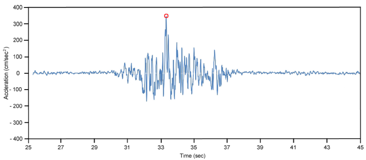
Figure 9 Acceleration time history of the 1822 earthquake at the citadel of Aleppo. This simulated result could be a tentative of reproducing the input motion of this severe earthquake.
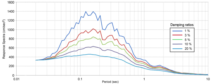
Figure 10 Response spectra of the 1822 earthquake at the citadel of Aleppo for different damping ratios. This simulated result could be a tentative of reproducing the input motion of this severe earthquake.
The simulated strong ground motion time histories and PSAs could be considered as the best kind of information required for engineering structural design in the absence of real accelerograms in Syria. However, these results need to be validated by comparison with the strong motion recordings when they become available. The direct comparison between simulation results and observed ground motions during real earthquakes allowed us to evaluate the efficiency and limitations of the simulation method. Complementary work should include the use of strong motion records when available and of physical models of propagation.
Discussions
This work provides additional details on the damages and loss of life in the cities of Aleppo, Antakia and Latakia and their surroundings due to the 1822 earthquake. However, the destruction and the human losses were not confined to these cities, but rather extended to other cities, towns and villages in northwestern Syria and the adjacent areas in central-southern Turkey as documented in Ambraseys (1989) and Sbeinati et al. (2005). Figure 8 shows a map with 63 cities, towns and villages affected by the 1822 earthquake. Furthermore, the intensity isoseismals for the main earthquake were assessed, considering the findings obtained by the results of previous works and by the current study as well. This map is generated by averaging the overall effects of the earthquake. As shown, a vast area in northwestern Syria and some adjacent regions in Turkey were damaged by the 1822 earthquake.
The whole macroseismic data of the 1822 earthquake suggests that the earthquake epicenter is more likely located on the central segment of the St. Simeon fault (SSF) which is located close to Aleppo city. This is attested by the large destruction and loss of life in the city. Although SSF is considered active from the geomorphotectonic evidence, paleoseismic investigation is undoubtedly requested to unveil the rupture of the 1822 earthquake in the sediments.
Some historical sources reported the occurrence of sea waves hitting Cypriot and Syrian coasts following the 1822 earthquake. For example, Neale (1854: xxiii-xxxiv) documented the observation of disturbance of the sea near the coast of Antakia. Also, Conder (1824: 298) mentioned that the earthquake was felt so violently at sea at a distance of about 11 km of Cyprus to the extent that it was thought the ships in Cyprus had grounded. In addition, a rising the rocky masses near Cyprus was documented on 3 September 1822 in a report of a caption of French ship departed from Cyprus to Latakia (Asiatic Journal, 1822: 519). These phenomena could be indirectly related to strong earthquakes such as 1822 earthquake. In this regard, Ambraseys and Barazangi (1989) presented a preliminary explanation about the association of large earthquakes that occurred in land along the DSFS with sea waves in the Syrian coast, stating that these sea waves may be caused by submarine landslides in the Levantine margin due to the presence of layers of Evaporators.
In this research, we use a stochastic finite-fault approach, allowing us to incorporate significant finite-fault effects such as the geometry of larger ruptures and its effects on attenuation, and directivity. The simulations are performed with the computer code EXSIM. Like most other stochastic finite-fault approaches, EXSIM does not assign a directivity effect to individual subfaults, but the effects of rupture propagation along the fault (from subfault to subfault) are assumed to mimic the overall directivity effect (Assatourians and Atkinson, 2007). However, the results of simulation of 1822 earthquake may be considered as a first approach to model the input motion of this severe earthquake. The synthetic accelerogram and response spectra (Figs. 9 and 10) show that the values of acceleration are less than 800 cm/s2 meaning that they are less than 1 g. However, these values could be reasonable regarding the observed damage in Aleppo city due to the 1822 earthquake.
Complementary work should include the use of strong motion records when available and of physical models of propagation, such as site effects, to get a more realistic simulation of this historical earthquake. Small to moderate magnitude events should be recorded at sites where strong motions of the historical events could be simulated. For this purpose, high-resolution strong motion network should be deployed in Syria. In this case, the results of simulation could be employed for conducting dynamic and response spectrum analysis of structures in the damaged regions, for earthquake resistant design.
There is still controversy among some Aleppine researchers on the origin of the disaster that struck Aleppo on the night of August 13, 1822. Some believe that the disaster resulted by a large meteor that fell near the village of Atarib, some 18 km to the west of Aleppo. They support their argument by the existence of a vast hole known as al-Hutah, with dimensions of about 150 meter in diameter, with a maximum depth of 70 meter. In this regard, two clear observations are presented discounting the previous hypothesis; i) The hole itself existed before 1822, as the both Scottish "Alexandar Russell” (1715-1768) and his half-brother “Patrick Russell" (1727-1805), physicians and naturalists of the British business community who lived in Aleppo in the mid-eighteenth century, described the hole (Russell, 1794: 57-58); and ii) the behavior of this natural phenomena, a main large seismic event proceeded by foreshocks and followed by a long series of aftershocks.
Concerning the archaeoseismicity, Kázmér and Major (2010) found traces of two historical earthquakes on the castle of al-Marqab, based on historical and archaeological evidence. The first one is the large magnitude earthquake of 1202 and the second one is related to an earthquake that happened after 1285. As the castle collapsed by the 1822 earthquake, it is believed that the second earthquake may be the 1822 earthquake. On the other hand, many other ruins of archaeological sites are distributed west and north-west of Aleppo at a short distance from the St. Simeon fault. These sites are part of the so-called the forgotten cities (e.g. Dar Qita, Deir Sita, Barisha, Burj Haidar, Mushabbak Basilica, Qalb Lozeh) flourished in the Byzantine period. Although the historical sources of information were silent on the effects the 1822 earthquake on these sites, Sbeinati et al. (1994) considers that these sites should have been strongly affected by the 1822 earthquake since they include strong evidence of seismic scars such as horizontal shifting, waved walls and fractures. However, further investigation is needed.
Based on the results of this study, the 1822 earthquake is named here as “The great Aleppo earth-quake”, considering that most serious damages and losses of life have concentrated in the city of Aleppo. In addition to the direct effects mentioned in this work, the earthquake caused long-term serious economic impacts. For example, Knost (2010), analyzing the proficiently economic impacts of the earthquake mentioned that the 1822 earthquake was one of the main reasons that contributed in the decline of the trade in Aleppo. Moreover, Bosworth (2007: 11) believes that the trade of goods between Europe and Asia has also declined because of 1822 earthquake in Aleppo.
Conclusion
Based on new contemporary and near contemporary Aleppine, English and French sources of information, this paper describes in detail the 1822 earthquake and its destructive impacts in Aleppo, Antakia, Latakia, and the immediate vicinity. Also, it presents the intensity map of the earthquake and showed the time series of the 1822 earthquakes. Moreover, the earthquake epicenter is suggested on the Saint Simeon fault. Using the stochastic extended simulation method, the strong ground motion of the 1822 earthquake at Aleppo citadel has been simulated.
Aleppo is situated at a very short distance from Antakia triple junction (ATJ). In and around the ATJ, numerous historical destructive earthquakes have occurred such as the last earthquake on 3 April 1872. This means that faults in the ATJ are mostly active and capable of producing large earth-quakes. This poses a genuine seismic potential hazards for Aleppo and other cities. If an earthquake like the earthquake of 1822 were to take place in northwestern Syria today, it is expected that the loss of life and damages will be considerably significant due to the large increase in the population and the presence of industrial facilities. Therefore, the results of this work should be of considerable interest in seismic hazard assessment and engineering design for the area.

