


Services on Demand
Journal
Article
 text in
  English (pdf)
 Article in xml format
 Article references
 Send this article by e-mail
Indicators
-
 Cited by SciELO
 -
 Access statistics
Related links
-
 Similars in
SciELO
Similars in
SciELO
Share

 Permalink
Agrociencia
On-line version ISSN 2521-9766Print version ISSN 1405-3195
Agrociencia vol.52 n.5 Texcoco Jul./Aug. 2018
Water-soils-climate
Potential influence of emissions and transport of N and S in the Orizaba Valley, Veracruz, Mexico
1 Facultad de Química, Universidad Autónoma del Carmen. Calle 56 No. 4 Esquina Avenida Concordia. 24180. Ciudad del Carmen, Campeche, México.
2 Departamento de Ciencias Matemáticas, Universidad de Wisconsin-Milwaukee. Milwaukee, P.O. Box 413. Milwaukee, WI 53201, USA.
3 Facultad de Ciencias de la Salud, Universidad Autónoma del Carmen. Calle 56 No. 4 Esquina Avenida Concordia. 24180. Ciudad del Carmen, Campeche, México.
4 Facultad de Ciencias Químicas, Universidad Veracruzana. Prolongación Avenida Oriente 6 No. 1009. Colonia Rafael Alvarado. 94340. Orizaba, Veracruz, México.
There have been few studies in Mexico about the atmospheric deposition of acidified substances that modify the balance of tropical mountain systems, which are highly sensitive to N and S compound deposits. The objective of this study was to evaluate the spatial and temporal distribution of N and S deposits during a year, in the Orizaba Valley, and to estimate the effect produced by the large-scale transport of SO2 regional emissions in S atmospheric deposits. The hypothesis was that N and S deposits in the Orizaba Valley are produced by local and regional sources, respectively. N and S deposits were measured in 2015, using passive collectors with ion-exchange resin (RII) in 10 sites, throughout the Orizaba Valley, Veracruz, Mexico. The ions (
Key words: atmospheric deposition; N; S; Orizaba Valley; Veracruz
El depósito atmosférico de sustancias acidificantes alteradoras del equilibrio de los sistemas montañosos tropicales altamente sensibles al depósito de compuestos de N y S se ha estudiado poco en México. El objetivo del estudio fue evaluar la distribución espacial y temporal del depósito de N y S, durante un año, en el Valle de Orizaba, y estimar el efecto del transporte a gran escala de emisiones regionales de SO2 sobre el depósito atmosférico de S en la región. La hipótesis fue que los depósitos de N y S en el Valle de Orizaba provienen de fuentes locales y regionales, respectivamente. Los depósitos de N y S se midieron en recolectores pasivos con resinas de intercambio iónico (RII) en 10 sitios, a lo largo del Valle de Orizaba, Veracruz, México, en 2015. Los iones retenidos (
Palabras clave: depósito atmosférico; N; S; Valle de Orizaba; Veracruz
Introduction
Non-controlled release of atmospheric pollutants increases the amount of acidifying substances in the atmosphere. In synergy with inappropriate forest management, these pollutants can damage forest ecosystems and produce soil acidification. In Mexico, since 1991, the Secretaría del Medioambiente y Recursos Naturales (SEMARNAT) established policies and regulations that, over the course of the last 20 years, have substantially reduced S emissions. However, in most cities, N compounds emissions have increased as a result of the car population. In Mexico, some zones are protected by the law; however, other zones are under anthropogenic stress caused by pollutants derived from urban and industrial sources and large-scale transport of regional emissions. Therefore, anthropogenic activities can modify mountain-valley systems because those systems are highly sensitive to N and S pollutants. In some cases, the emissions generated by urban and industrial corridors increase the S deposit patterns upwind (Baron et al., 2000; Benedict et al., 2013).
Despite the importance of the study of N and S deposits, the efforts made by Mexico have been focused in ecosystems located near polluted areas, such as Desierto de los Leones and Zoquiapan, in the Valley of Mexico (Fenn et al., 2002; Pérez-Suárez et al., 2008). There have not been enough studies about deposit patterns and their distribution in tropical mountain systems. Due to the complex relationship between the atmospheric deposition, the land, and the lack of monitoring stations in high places, there is not enough knowledge of the spatial patterns of those deposits in mountain areas (Weathers et al., 2000; Weathers et al., 2006). The lack of information is partly caused by the difficulty to reach those places and the lack of electric power. Therefore, simple, inexpensive, user-friendly (and that do not require frequent on-site visits) sampling devices are required. Ion-exchange resins (RII) based passive collectors are used to measure the atmospheric deposit in different ecosystems with a highly spatial resolution (Weathers et al., 2000; Fenn and Poth, 2004; Root et al., 2013). RII-based passive collectors is widely used in Europe and USA (Ivens, 1990)[5] to estimate atmospheric deposits in forest ecosystems, since they include both dry and wet deposits. Passive collectors provide reliable estimations for a specific place, due to the associated costs, the specific requirements of (wet/dry) automatic collectors, and the representative dry deposit measurements (Butler and Likens, 1995). Passive collectors were developed by Fenn and Poth (2004), which are made of a bed mixed with RII inside a column. Their main advantages are that they can be used constantly during relatively long periods (months) and that their cost is low. This increases the number of sample sites in a given area.
Passive estimations of N and S deposits are useful to establish a base line in areas where no atmospheric deposition data are available. A comprehensive database about atmospheric deposition of N and S is included in the literature. Therefore, estimated atmospheric inputs can be compared using reference values, in order to obtain a diagnosis of the severity of the atmospheric pollutants deposits and the potential vulnerability of the ecosystems. The objective of this study was to evaluate the spatial and temporal distribution of the N and S deposits in the Orizaba Valley (2015) and to estimate the effect of the large-scale transport of the SO2 regional emissions in the S atmospheric deposit. The hypothesis was that the N and S deposits in the Orizaba Valley come from local and regional sources, respectively.
Materials and Methods
Study area
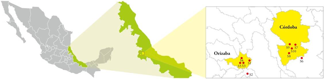
The study area is located in the Orizaba Valley, in the center of Veracruz, Mexico, including the cities of Orizaba and Córdoba (Figure 1). This region is characterized by its high agricultural activity and many industrial sources, as well as the emissions associated with vehicular sources from the 150D highway (one of the most important highways in Mexico). Additionally, the Orizaba Valley is located downwind from important urban and industrial zones, where oil and oil products are the main productive activity. The sampling areas were distributed as follows: sites S1 to S5 were located in the City of Orizaba and sites S6 to S10 were located in the City of Córdoba (Figure 1).
Sampling and analysis procedure
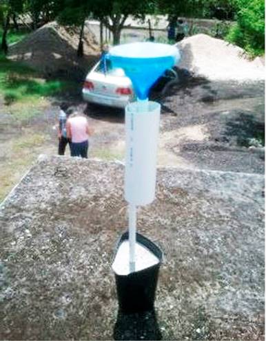
The experimental design was a simple classification comparison, with three treatments (climatic season: dry, rainy and cold front seasons) and 10 experimental units (sites S1 to S5 in the City of Orizaba and sites S6 to S10 in the City of Córdoba). The response quantitative variables were classified based on four-month and total flows (1 year) of the N and S atmospheric deposit in the Orizaba Valley region. The collector was made of a funnel attached to a PVC tube, connected to a column that contained 30 g of RII (AmberliteTM IRN 150). The column was sealed using fiberglass at the top (as a filter) and at the bottom (as a support platform). The funnel was covered with a mesh to prevent solid matter (leaves and bugs) from entering. The column was placed inside a PVC tube to protect the resin from direct solar radiation. The bottom of the column was connected to an open PVC standard valve, allowing the flow to drain. The sampling devices were left outdoors. The funnel sent the solution of the collected samples through the RII column, where ions were retained (Fenn and Poth, 2004; Root et al., 2013) (Figure 2).
The sampling was carried out from January 1 to December 31, 2015, and it was divided into three sampling sub-periods (4 months each). This included the three main seasonal periods: cold fronts (nortes), dry, and rainy seasons. At the end of each sampling sub-period, ions were recovered using a KCl 2 N solution and specifically designed devices. RII columns were extracted in two sequences, using 100mL of KCl 2 N. Those extracts were analyzed, in order to determine
The
Meteorological data
In order to trace the origin of air masses during the study, the air mass trajectories were estimated for the 96 previous hours for the selected sites and dates in the Orizaba Valley. The U.S. NOAA’s HYSPLIT model (Hybrid Single Particle Lagrangian Integrated Trajectory Model) was used to carry out this task (https://ready.arl.noaa.gov/HYSPLIT_traj.php).
Results and Discussion
Flow of de
The flows of
Flows of
Flows of
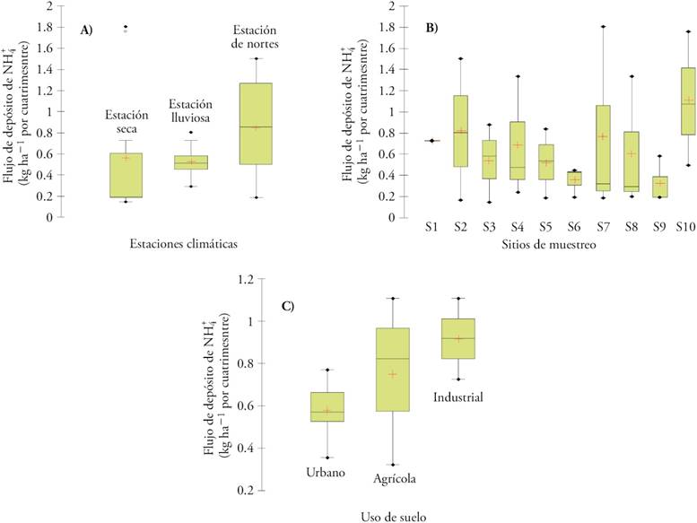
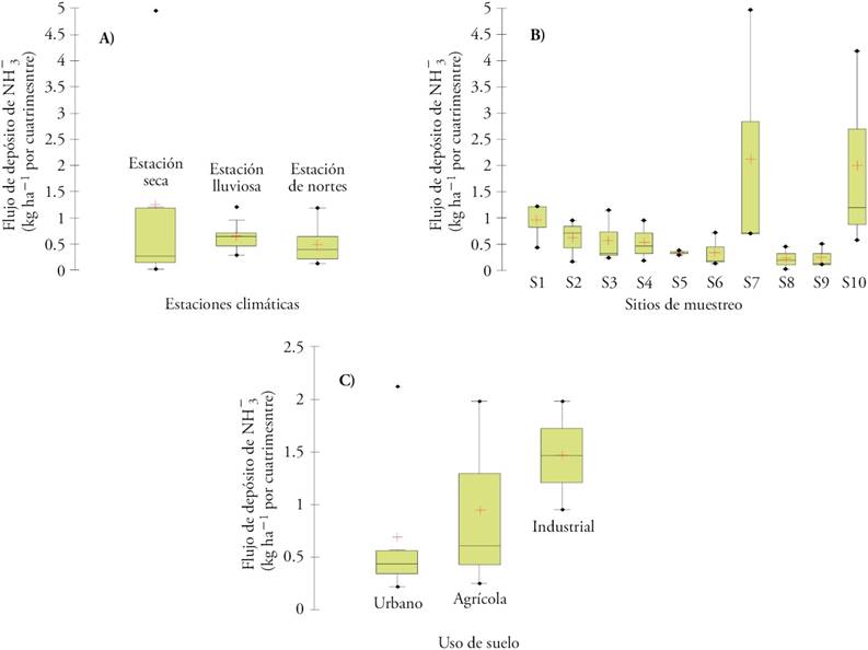
The ion had a seasonal pattern, with higher levels during rainy and cold front seasons (Figure 5A). This behavior matches the SO2 regional character in the atmosphere (Seinfeld and Pandis, 1998). Since
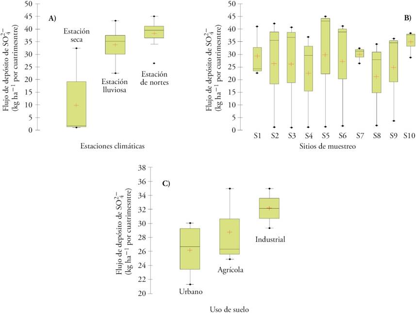
Figure 5 Flows of
In addition to the large-scale transport of SO2, industrial sources in the region significantly contributed to pollution (Figure 5B and C). However, background levels of sulfate in the Orizaba Valley influenced the whole region, as a result of large-scale transport (Figure 5A). The relative contribution of regional sources can be categorized as follows: industrial ˃ agricultural activities ˃ vehicular sources.
Effect of regional emissions transported at large-scale over the S deposit in the Orizaba Valley
Large-scale atmospheric circulation
According to the last Mexican domestic emissions inventory (http:/sinea/semarnat.gob.mx/sinea.php), SO2 emissions (t year-1) were 576 247.83, 15 104.43, and 167 448.54, for Campeche, Tabasco, and Veracruz, respectively. Therefore, the three states jointly contributed 33.85 % to the total SO2 emissions in the country. Campeche contributes 25.71 %. The Coatzacoalcos-Minatitlán industrial corridor -where oil refineries and chemical and petrochemical industries are located- is found east-southeast of the Orizaba Valley. The Secretaría de Medioambiente y Recursos Naturales (SEMARNAT) considers it as an atmospheric pollutant critical zone. Numerous land oil facilities are found in Tabasco -including exploration and production facilities, shipping and storage terminals, and gas processing plants. Additionally, offshore oil and gas exploration and production is carried out in the coast of Campeche. Most of the facilities are located in the Sonda de Campeche and include a sour gas recompression plant (in the Atasta Peninsula), which receives and processes the gas sent from the offshore platform. Therefore, high
In certain weather scenarios SO2 emissions are transported to the Orizaba Valley. SO2 emissions generated in offshore platforms (Figures 6A, B, and C) and in land gas, fuel, oil, and oil products facilities (Figure 6F: Coatzacoalcos-Minatitlán, Atasta and oil fields in Tabasco) affected the Orizaba Valley during this study. During the cold front season, air masses were transported from northern Mexico. As a result, sources from that direction might have contributed to the sulfate levels in the Orizaba Valley (Figures 6 D and E). Thermoelectric plants and oil facilities can be found to the North of the cities of Altamira (Tamaulipas) and Poza Rica (Veracruz). Along with the cities of Tampico and Matamoros (Tamaulipas), Monterrey (Nuevo León), and Brownsville (Texas), they might have contributed additional pollutants. These results match the findings of Kahl et al. (2007), who proved a large-scale transport from these two areas to northern Veracruz.
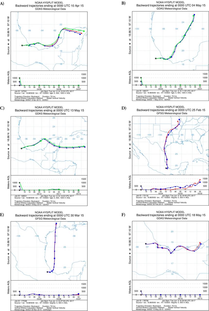
Kahl et al. (2007) studied the large-scale transport towards El Tajín. They used weather resources such as global wind field re-analysis, air mass trajectory analysis, and local sources measurement. In this way, the emission and transport of precursor chemicals of acids from potential significant sources were identified, such as offshore oil fields in the south of the Gulf of Mexico and oil facilities in Astata and Dos Bocas, in Campeche and Tabasco. Based on the air mass trajectories during the 5 d since their arrival, Kahl et al. (2007) established two weather regimes that control the transport to northern Veracruz. One was the eastern flow that dominates the transport during the summer (from June to August), when air mass trajectories go through the Caribbean Sea, crossing the Yucatan Peninsula and the south of the Gulf of Mexico (the Sonda de Campeche, where the offshore platforms are located). The second was a north-northwest flow, associated with the North American anticyclonic circulation. This flow affects the atmosphere during winter or cold front seasons, favoring the transport from central and southern USA -with air mass trajectories that go through Texas, the North of the Gulf of Mexico (where oil facilities can also be found), and northern Mexico- before it arrives to El Tajín. Additionally, Kahl et al. (2007) reported that, from June to August -when the transport direction during several days (5 d) come from the East-, the air remains at a low altitude (200-600 msnm). Under these conditions, regional sources make a significant contribution to pollution.
The straight distance between El Tajín and the offshore platforms of the Sonda de Campeche (approximately 500 km) can be compared with the distance between the Orizaba Valley and the platforms in the State of Campeche (approximately 450 km East). The estimate transport from the oil platforms in the Sonda de Campeche to the Orizaba Valley takes 1 to 5 days (as a wind speed function). Therefore, both flows probably also affect the air mass transport when they arrive to Orizaba Valley, during rainy and cold fronts seasons (Kahl et al., 2007). Regarding the influence of local phenomena, mountain-valley breeze systems created by regional topography can contribute to the variation of the pollutant concentration between areas. To support this hypothesis, a daily sampling protocol (with a daily resolution) must be applied. During the development of this study, air quality monitoring stations were not available in the Orizaba Valley.
The regional nature of sulfate and its precursors
The
Flows of deposit and reference values
Critical loads have been estimated for several regions of the world. Alpine ecosystems -which are more sensitive than lowlands ecosystems- showed a critical load of 5 kg N ha-1 year-1 (Fenn and Geiser, 2011), while Nuevo Mexico and California have reported reference values of 3.8 kg N ha-1 year-1 and 4-7 kg N ha-1 year-1, respectively (Grennfelt and Nilsson, 1988). A critical load of 3 kg S ha-1 year-1 and 2-5 kg S ha-1 year-1 have been proposed for very sensitive areas and for natural forests, respectively. In Mexico, no critical load values are available and there are very few studies about this subject (mainly focused in pine forests). Atmospheric inputs of 15 kg ha-1 year-1 were reported for pine groves in Desierto de los Leones, on the outskirts Mexico City (Fenn et al., 2002), while in Zoquiapan -a place located to the east and upwind from Mexico City- N and S inputs of 5.5 and 8.8 kg ha-1 year-1, respectively, were reported (Pérez-Suárez et al., 2008).
The magnitude of the S flows in our study was similar to those found in some temperate mountain regions in Mexico. A research carried out in central Veracruz about several types of vegetation covers and soil uses reports 6-27 kg ha-1 year-1 and 2-4 kg ha-1 year-1 inputs for S and N, respectively (Ponette-González et al., 2010). Flows of S obtained by Ponette-González et al. (2010) can be compared with those found in forests around Mexico City that receive from 9 to 20 kg S ha-1 year-1 (Fenn et al., 1999). According to Ponette-González et al. (2010), certain zones in central Veracruz face an acidification risk and that uplands are downwind from the more important industrial zones in Mexico, where facilities that emit significant amounts of SO2 are concentrated. Those facilities include thermoelectric plants, gas and oil extraction facilities and refineries, petrochemical plants, paper industry facilities, and sugar refineries. The findings of Ponette-González et al. (2010) matched those reported by Parungo et al. (1990), who observed that upwind anthropogenic sources increase S deposits in mountain ecosystems in Sierra Madre Oriental (State of Veracruz). The results found by Parungo et al. (1990), Kahl et al. (2007), and Ponette-González et al. (2010) support the hypothesis established in our research. In our study, the mean flows of deposits estimated for N (as
Cerón et al. (2015) and Cerón et al. (2016) reported flows of N deposits of 0.8 and 2.15 kg ha-1 per each four-month period for Astata and Ciudad del Carmen, respectively. Both cities are located in Campeche. These levels are not significantly different from those obtained in our study, suggesting a local origin in all cases. Nevertheless, for S deposit, Cerón et al. (2015) reported 9.22 and 4.7 kg ha-1 per each four-month period for Astata and Ciudad del Carmen, respectively. These values are lower than the ones obtained in our study. It is important to mention that Ciudad del Carmen is located upwind from Atasta and that, in turn, Atasta is located upwind from the Orizaba Valley. Both zones are located east of the Orizaba Valley and the more important emission points are located in Campeche. Since SO2 is a regional pollutant, its deposits do not affect the surroundings of its emission point. As a result of its spatial and temporal variability -as well as its residence time in the atmosphere-, it becomes a sulfate deposit in downwind sites which are relatively distant from its source.
Levels of S tend to increase in areas located west of the Sonda de Campeche (Figure 7). SO2 stays in the atmosphere approximately 2-5 d; this is enough time for the air masses to cross southeastern and northern Mexico, with a West-Southwest component (during rainy and cold front seasons). Along this trajectory, SO2 is transformed and deposited as
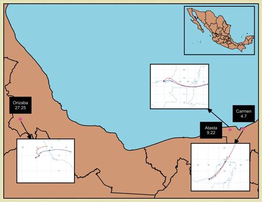
Figure 7 Trend of the S deposit in kg ha-1 year-1 for Ciudad del Carmen (Campeche), Atasta (Campeche), and the Orizaba Valley, as the air masses that travel from the East-Northeast direction to the West-Southwest direction.
The studies about the flows of S deposits are scarce in Mexico and there are not enough data to evaluate this variation. Additionally, there are not environmental monitoring networks in southern Mexico that measure meteorological variables -such as speed and direction of the wind, and relative humidity. Therefore, the SO2 levels in this region remain unknown and they cannot be correlated with the flows of S deposits.
Conclusions
The atmospheric deposits of
REFERENCES
Baron, J. S., H. M. Rueth, A. M. Wolfe, K. R. Nydick, E. J. Allstott, J. T. Minear, and B. Moraska. 2000. Ecosystem responses to nitrogen deposition in the Colorado Front Range. Ecosystems 3: 352-368. [ Links ]
Benedict, K. B., D. Day, F. M. Schwandner, S. M. Kreidenweis, B. Schichtel, W. C. Malm, and J. L. Collett Jr. 2013. Observations of atmospheric reactive nitrogen species in Rocky Mountain National Park and across northern Colorado. Atmos. Environ. 64: 66-76. [ Links ]
Butler, T. J., and G. E. Likens. 1995. A direct comparison of throughfall plus stemflow to estimates of dry and total deposition for sulfur and nitrogen. Atmos. Environ. 29: 1253-1265. [ Links ]
Cerón B., R. M., J. G. Cerón B., M. Muriel, F. Anguebes, M. Ramírez, J. Zavala, C. Carballo, and R. C. Escoffie. 2015. Spatial and temporal distribution of throughfall deposition of nitrogen and sulfur in the mangrove forests associated to Terminos Lagoon. In: Nejadkoorki, F (ed). Current Air Quality Issues. INTECH Open Access Publisher. Rijeka, Croatia. pp: 147-164. [ Links ]
Cerón J., R. Cerón, C. Aguilar, C. Montalvo, A. García, M. Muriel, E. Ramírez, A. Córdova, and C. Carballo. 2016. Mapping temporal and spatial variation of sulphur and nitrogen deposition to a complex ecosystem in Campeche, Mexico. Trans. Ecol. Environ. 203: 113-123. [ Links ]
Escoffie, R. C., R. M. Cerón, J. G. Cerón, E. C. Guevara, C. G. Carballo, J. A. Benítez, J. C. Zavala, F. Anguebes, and M. Ramírez. 2014. Throughfall deposition of N and S to mangrove ecosystems in the Southeast of Mexico. In: Cerón Bretón, J. G., Quartieri, J., Guida, M., Guida, D., Guarnaccia, C. (eds). Latest Trends in Energy, Environment and Development. Salerno, Italy. June 3-5 WSEAS. pp: 59-65. [ Links ]
Fenn, M.E., L.I. de Bauer, K. Zeller, A. Quevedo, C. Rodríguez, and T. Hernández-Tejeda. 2002. Nitrogen and sulfur deposition in the Mexico City Air Basin: Impacts on forest nutrient status and nitrate level in drainage water. In: Fenn, M.E. , L.I. de Bauer., and T. Hernández-Tejeda (eds). Urban Air Pollution and Forest Resources at risk in the Mexico City Air Basin. Springer-Verlag, New York. pp: 298-319. [ Links ]
Fenn, M. E. and L.H. Geiser. 2011. Temperate Sierra. In: Pardo, L.H., M.J. Robin-Abbot, and C.T. Driscoll (eds). Assessment of nitrogen deposition effects and empirical critical loads of nitrogen for ecoregions of the United States. United States Department of Agriculture. General Technical Report NRS-80. Delaware, OH. pp: 175-180. [ Links ]
Fenn, M. E., and M. A. Poth. 2004. Monitoring nitrogen deposition in throughfall using ion exchange resin columns. J. Environ. Qual. 33: 2007-2014. [ Links ]
Finlayson-Pitts, B. J., and J. N. Pitts. 1986. Atmospheric Chemistry. Fundamentals and Experimental Techniques. John Wiley & Sons. New York, N. Y. 1098 p. [ Links ]
Fresenius, W., K. E. Quentin, and W. Schneider (eds). 1988. Water Analysis: A Practical Guide to Physico-Chemical, Chemical and Microbiological Water Examination and Quality Assurance. Springer-Verlag. New York, N.Y. pp: 420-421. [ Links ]
Grennfelt, P., and J. Nilsson. 1988. Critical loads for sulphur and nitrogen. In: Report from a Workshop of Nordic Council Ministers. 19-24 March. Skokloster, Sweden. 418 p. [ Links ]
Kahl, J. D. W., H. Bravo-Álvarez, R. Sosa-Echeverría, P. Sánchez Álvarez, A. L. Alarcón-Jiménez, and R. Soto-Ayala. 2007. Characterization of atmospheric transport to the El Tajín archaeological zone in Veracruz, México. Atmósfera 20: 359-371. [ Links ]
Khoder, M. I. 2002. Atmospheric conversion of sulfur dioxide to particulate sulfate and nitrogen dioxide to particulate nitrate and gaseous nitric acid in an urban area. Chemosphere 49: 675-684. [ Links ]
Noone, K. 2012. Human impacts on the atmosphere. In: Matthews, J.A. (ed). The SAGE Handbook of Environmental Change. Volume II. SAGE Publications Ltd. Thousand Oaks, CA., USA. pp: 95-110. [ Links ]
Parungo, F., C. Nagamoto, S. Hoyt, and H. Bravo A. 1990. The Investigation of air quality and acid rain over the Gulf of Mexico. Atmos. Environ. A-Gen.. 24: 109-123. [ Links ]
Pérez-Suárez, M., M. E. Fenn, V. M. Cetina-Alcalá, and A. Alderete. 2008. The effects of canopy cover on throughfall and soil chemistry in two forest sites in the Mexico City air basin. Atmósfera 21: 83-100. [ Links ]
Pierson, W. R., and W. W. Brachaczek. 1983. Emissions of ammonia and amines from vehicles on the road. Environ. Sci. Technol. 17: 757-760. [ Links ]
Ponette-González, A. G., K. C. Weathers, and L. M. Curran. 2010. Tropical land-cover change alters biogeochemical inputs to ecosystems in a Mexican montane landscape. Ecol. Appl. 20: 1820-1837. [ Links ]
Root, H. T., L. H. Geiser, M. E. Fenn, S. Jovan, M. A. Hutten, S. Ahuja, K. Dillman, D. Schirokauer, S. Berryman, and J. A. McMurray. 2013. A simple tool for estimating throughfall nitrogen deposition in forests of western North America using lichens. Forest Ecol. Manag. 306: 1-8. [ Links ]
Secretaría de Economía. 2015. Norma Mexicana NMX-AA-074-SCFI-2014. Medición del ión sulfato en aguas naturales, residuales y residuales tratadas-Método de prueba, Dirección General de Normas. [ Links ]
Secretaría de Economía. 2000. Norma Mexicana NMX-AA-079-SCFI-2001. Análisis de Aguas - Determinación de Nitratos en Aguas Naturales, Potables, Residuales y Residuales Tratadas - Método de Prueba, Dirección General de Normas. [ Links ]
Seinfeld, J. H. and S. N. Pandis. 1998. Atmospheric chemistry and physics: from air pollution to climate change. John Wiley & Sons. New York, N. Y. 1326 p. [ Links ]
Weathers, K. C., G. M. Lovett, G. E. Likens, and R. Lathrop. 2000. The effect of landscape features on deposition to hunter mountain, Catskill Mountains, New York. Ecol. Appl. 10:528-540. [ Links ]
Weathers, K. C., S. M. Simkin, G. M. Lovett, and S. E. Lindberg. 2006. Empirical modeling of atmospheric deposition in mountainous landscapes. Ecol. Appl. 16: 1590-1607. [ Links ]
Received: June 2017; Accepted: November 2017
 Este es un artículo publicado en acceso abierto bajo una licencia Creative Commons
