


Services on Demand
Journal
Article
 English (pdf)
 Article in xml format
 Article references
 Send this article by e-mail
Indicators
-
 Cited by SciELO
 -
 Access statistics
Related links
-
 Similars in
SciELO
Similars in
SciELO
Share

 Permalink
Frontera norte
On-line version ISSN 2594-0260Print version ISSN 0187-7372
Frontera norte vol.27 n.54 México Jul./Dec. 2015
Artículos
Ecological Transformation and Territorial* Synergies in the Hermosillo, Sonora Coastal Strip
Transformación ecológica regional y sinergias territoriales en la franja costera de Hermosillo, Sonora
Hugo César de la Torre Valdez1, Sergio Alfonso Sandoval Godoy2
1 Independent consultor / Part time professor hugo_cesar@estudiantes.ciad.mx
2 Centro de Investigación en Alimentación y Desarrollo ssandoval@ciad.mx
Date of receipt: June 23, 2014.
Date of acceptance: October 22, 2014.
ABSTRACT
This article discusses the territorial implications generated by three productive activities in the Hermosillo, Sonora coastal strip: charcoal production, harvesting of marine species, and shrimp farms. Data were obtained through semi-structured interviews and the generation of a complex database. The results indicate a loss of mesquite ecosystems, an increased denuding of rangeland, wide variation in the catch of various species in coastal fisheries, complete loss of vegetation in some places, and a change in the hydrology in aquaculture zones. Finally, the article analyzes a set of synergies that positively articulate the three activities in some cases, but generate unhealthy competition in others.
Keywords: territory, shrimp farming, charcoal production, coastal fisheries, Hermosillo coast.
RESUMEN
En este artículo se analizan las implicaciones territoriales que generan tres actividades productivas en la franja costera de Hermosillo, Sonora: elaboración de carbón vegetal, captura de especies marinas y cultivo de camarón. Se obtuvieron datos por medio de entrevistas semiestructuradas y construcción de indicadores territoriales. Los resultados señalan: pérdida de ecosistemas de mezquite, incremento de suelos desnudos en agostaderos, variación de especies de captura ribereña, pérdida de vegetación y modificación de hidrología en áreas acuícolas. Finalmente se analiza un conjunto de sinergias que, en algunos casos, articulan positivamente el aprovechamiento de las tres actividades, mientras que en otros provocan competencia.
Palabras clave: territorio, camaronicultura, producción de carbón vegetal, pesca ribereña, costa de Hermosillo.
INTRODUCTION
In recent decades, Mexico's coastal regions have undergone social, productive, territorial, and ecological changes, highlighted by population migration, development of new economic activities, human settlements with various levels of income, and overexploitation of natural resources. This has allowed the coastal areas to be characterized as transition zones of high fragility and as complex systems with a diversity of marine and land resources (Castillo, Ulloa and Alvarado, 2009) that consolidate a regional overview of a multisectoral nature.
This has been the case with the Hermosillo Coast, an agricultural and fishing region located in the west of Sonora state that in recent decades registered an intensive process of transformation, caused by the spatial, territorial, and temporal confluence of three economic activities that we will call utilizations or inductive factors: charcoal production in ejidos, capture of marine species by coastal communities, and shrimp farming. This process has been linked to differentiated use of the soil and of the benefits of nature in ten localities, which have been undergoing reconfiguration and modification in the productive context, such as the food chains of the ecosystem. The results presented below indicate a loss of ecosystems, an increase in bare soils in ejido pastures, variations in the species caught in coastal fisheries, complete loss of vegetation, and a change in the surface water hydrology in aquaculture areas. The above are part of a set of territorial synergies that in some cases articulate positively with the harvests generated, while in others bring about competition and friction between various users who contest the appropriation of the territory.
To study the process of regional transformation of the area of study (Map 1), the concept of the coastal strip was limited to one that begins 15 kilometers from the coastline, going both inland and into the sea, and that covers the area of all the utilizations included in the analysis. It was necessary to weave in spatial data with territorial indicators from the National Institute of Ecology and Climatic Change (Instituto Nacional de Ecología y Cambio Climático, known by its Spanish acronym INECC) through a Geographic Information System. The technique of geometric superimposition with vector graphics of the National Forestry Inventory was applied, and was compared with data obtained through an unofficial classification of vegetation in ejido pasture areas, space taken up by aquaculture, and the hydrology of the area. This technique was designed using the programs Arcview 3.3, ENVI 4.5, and ArcMap 10 with Landsat and Aster satellite images for various years, digitization of the hydrology of the area, and field corroboration of the sites. For the analysis of the fishing activity, the study examined production and operation databases generated by the State Office for Information for Sustainable Development (Oficina Estatal de Información para el Desarrollo Rural Sustentable, known by its Spanish acronym Oeidrus Sonora) and by the Committee for Aquaculture Health of the State of Sonora (Comité de Sanidad Acuícola del Estado de Sonora, A. C., known by its Spanish acronym Cosaes). Furthermore, key actors (ejido leaders, coastal fishermen, and shrimp farm technicians and producers) were consulted through semi-structured interviews. The central objective of the compilation of information was directed at understanding the perception of the social actors about the various production scenarios, the process of transformation, to identify conflicts, and to have a prospective analysis of its context. This set of procedures and techniques was articulated with a theoretical conceptual approach based on territory as a condition to interpret the transformations in the regional scenario of the coastal strip, defined as a set of ecological and social scales in constant change through the incidence of anthropogenic activities (Gómez, 2007; Castro, 2008) tied to the intervention of key actors in the procedure of building, adapting, and utilizing their environment (Giménez and Héau, 2007; Toledo, 2008).
The objective of this article is to analyze the implications of the territorial dynamics generated by the cited inductive uses of the Hermosillo coastal strip, within the context of the ecological depletion of the region. The productive overview of the Hermosillo Coast is described as on the cusp of being a zone shocked by the excessive use of coastal resources. An analysis is later presented of each one of the inductive factors and their ecological implications. Furthermore, the territorial changes and their social relevance in the progress of regional transformation are described. Finally, information is integrated to identify the synergies and consequences of each one of the utilizations of the area of study.
THE TERRITORIAL APPROACH IN THE TRANSFORMATION OF COASTAL REGIONS
The close association and confluence of variables of several types in the configuration and transformation of coastal zones has questioned the orthodox views of regional analysis, oriented toward maintaining the division between disciplines of the social and natural sciences (Breton, 2001); at the same time it has generated the need for a regional and systematic vision to tackle the issue through a territorial approach (Boisier, 2010). This explains the development of a set of utilizations that slowly occur in the regional ecological transformation, whose problem is constituted of cyclical phenomena of exhaustion of resources in processes of interdependence of productive activities, of appropriation, competition, and utilization of territory. These phenomena can be understood as synergies generated by the occurrence of various sectors in a common space that gives rise to inductive factors, capable of interrupting the food chains of the environment (Gómez, 2007; Cerdan, Aquilante and Freire, 2011; Colinvaux, 1995). In that sense, the territory is seen as a systemic framework of reference, through ecological and social scales (Gómez, 2007; Castro, 2008) in which processes of appropriation are identified (Giménez and Héau, 2007) and where the subjects articulate with their ecological dimension through work (Toledo, 2008). Thus, the territory exerts endogenous mechanisms of regulation with those that develop ecological events and distribution of populations, defined as processes of self-organization and fluctuations of physical elements (Margalef, 1977), which can also be induced by external factors (Colinvaux, 1995). Human intervention produces an accumulation of tangible and intangible resources available for its management (Castro, 2008). The tolerance of the users of the territory to adversity or recovery in the face of various shocks through mechanisms of self-organization and adaptation will depend on the level of resilience they develop (Rescia, Fungariño and Dover, 2010). This response depends on the ability to absorb, utilize, or even come to benefit from the shocks and the changes the inductive factors exert (Young et al., 2006). In this sense, social capital contributes to the construction of responses that are able to maintain management of the territory (Ostrom, 2000), which is able to consolidate itself over time (Szauer and Castillo, 2003) through an accumulation of interpersonal relationships where the cohesion between various social actors is essential (Madrid, 2003). Thus, the territorial approach, seen through a local-regional vision, encompasses a particular analysis about the use of available natural resources and their management. The territorial synergy that is developed between various utilizations leads to the identification of mechanisms of inclusion and exclusion, above all when there is a common interest for some resource, space, or benefit that it generates (Gómez, 2007; Cerdan, Aquilante and Freire, 2011). Similarly, the influence of the regional context (political-social-economic-environmental) involves its response dynamic in the environment (Boisier, 2010).
PRODUCTIVE CONTEXT OF THE HERMOSILLO COAST
Until the end of the 1980s, the Hermosillo coastal strip was crossed by a process of ecological and productive transition where a set of inductive factors flowed, with specific productive cycles resulting from the particular characteristics of each activity at the territorial level. This has as its background the exploitation of the aquifer and the agricultural crisis, two phenomena that influenced, directly and indirectly, the rest of the local activities (Moreno, 2006). The weakening of agricultural production contributed to the transformation of the zone, marked by ecological occurrences in abandoned fields and a process of desertification at the regional level (Castellanos et al., 2009; Martínez, 1998). The ejido members of the coastal strip were articulated with agriculture as a complementary source of income to charcoal production (Moreno, 2006). Thus, forestry use increased as an alternative for the agricultural workers lacking employment (Sedesol, 2011). Furthermore, the closure of cropland contributed to an intensification of the harvesting of wood in pasture areas, weakening the utilization of mesquite and damaging ejido land, which translated into wood overexploitation (Cabazos, 1997; Rosas, 1992). At the same time, the agricultural crisis led some of the older workers to seek fishing work, which increased the number of independent fishermen; this took the numbers outside the norm and affected the control over the fishing effort in the region (Inapesca, 2012; Delgado, 2003). In addition to the above, the deterioration of the fishing gear of the coastal fishermen, internal divisions in the associations representing them, and territorial disputes between local and foreign groups led to an irrational use of natural resources (Montemayor and Molina, 2002; Moreno et al., 2005).
During its declining productive-ecological cycle, the Coast experienced the development of shrimp farming. Its territorial participation was limited to the utilization of the coastal strip (Nava, 2003), emerging as a new activity inspired in the successful experiences in the south of Sonora, which benefited from the decree of constitutional reforms of those years that allowed extending its physical presence into ejido zones and its exclusive participation in this fishery production; furthermore, it benefited from the political strategies of the Comprehensive Agrarian Plan of Sonora (Plan Agrario Integral de Sonora, known by its Spanish acronym pais), which integrated the ejidos into the incipient activity (DeWalt, et al., 2002; Ramos, 1989; Luers, Naylor and Matson, 2005). The new context generated intersectoral synergies with local activities through the territorial relationship that was established with the coastal fishery, through the utilization of maritime space through water intakes and aquaculture discharges (Semarnat, 2006; Ramírez, 2010; Rodríguez, Crespo and López, 2010). At the land level, synergies were developed with ejidos in areas of wood harvesting and plots of extensive salt flats without apparent use (Ramos, 1989; Nava, 2003).
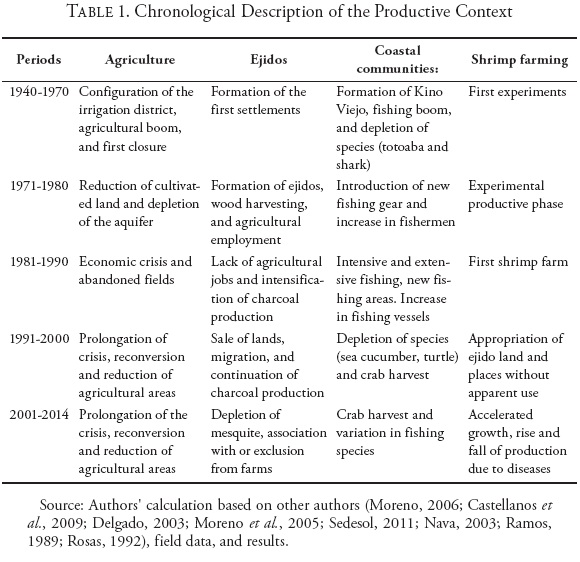
Consequently, from the 1990s to date, a period of productive transition and continual ecological transformation took shape. This phenomenon took place in a declining agricultural context (Salazar, Moreno and Lutz, 2012); with charcoal activity debilitated by mesquite deforestation, combined with unfavorable climatic conditions (Rosas, 1992); and with coastal activity immersed in sectoral and environmental conflicts (Doode and Wong-González, 2001). However, shrimp farming experienced an accelerated growth, becoming the activity with greater development expectations, as well as its inherent risks (Páez, 2005; Miranda, 2004) (Table 1).
INTRODUCTIVE FACTORS AND ECOLOGICAL ANSWER
Wood Harvest: Producing Charcoal and Depletion of Mesquite in Ejido Pasture Areas
The wood harvest for charcoal production in pasture areas represents an inductive factor of ecological transformation through the cutting of mesquite (Prosopis spp.). The activity has had productive cycles depending on variations in the economic context of the region. The ejidatarios say they generated a moderate harvest in the 1960s and 1970s, influenced by being able to raise income from outside their plots. In the 1980s this intensifies in the face of the cropland closures. Finally, from the 1990s to date, the harvest diminished as a result of aquaculture development. To see how widespread this was, information was taken from the data of each National Forestry Inventory (Inventario Nacional Forestal, known by its Spanish acronym INF), whose results reflect variations through the transition of environments of each associated class: mesquite, dune vegetation, without apparent vegetation/not applicable (WAV/NA), scrubland and halophiles1 (Table 2).
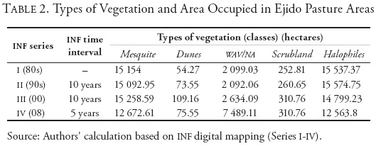
The negative variations in changes of coverage are located in mesquite environments reduced by 2 481.39 hectares, as well as halophiles by 2 973.57 hectares. Negligible increases occur in coastal dune ecosystems (21.28 hectares) and scrubland environments (57.95 hectares). The noteworthy increase corresponds to areas without apparent vegetation associated with productive land use with 5 390.08 hectares. This increase comes through development of aquaculture projects and the intensification of charcoal activity as a result of the aquaculture incursion generating a reduction in vegetation, replacing areas of apparent bare soil and removing biomass from the subsoil, on the one hand, and on the other, the wood harvest contributing to the expansion of areas without apparent vegetation and a reduction in mesquite environments.
To identify in greater detail the inductive level that the charcoal activity has and to verify the INF results, it was necessary to generate a self-classification using satellite images from various years. Five spectral signatures were analyzed, three grouped in vegetation: dense, disperse, and without apparent vegetation; and two classes without associated vegetation: bare soils and aquaculture use (Table 3).
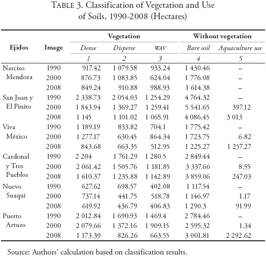
In 1990, the pastures presented the following classes in area: dense, 9 289.8 hectares (24.34 %), disperse, 8 118.23 hectares (21.27 %), WAV, 6 043.61 hectares (15.83 %), bare soils, 14 721.64 hectares (38.57 %), and aquaculture use, cero hectares (0 %). Between 1990 and 2000 there was an intensified prolongation of mesquite cutting, with a reduction in the dense and disperse classes of 413.74 and 1 714.99 hectares with a percentage variation of 23.35 and 16.77 percent, respectively. Following the described sequence, an increase was seen in WAV of 313.95 hectares (16.65 %), in bare soils of 1 399.78 hectares (42.23 %), and of the incursion of aquaculture with 415 hectares (1.09 %). The variations indicate a process of gradual transformation over time where charcoal production intensified, with aquaculture's presence still negligible. The ecological response was a loss of vegetation and an increase in bare soils and in areas without apparent vegetation.
Between 2000-2008, all the classes of vegetation decreased, accompanied with the increase in bare soils, to which the aquaculture growth contributed to a greater extent. The areas of dense vegetation fell by 2 634.45 hectares, corresponding to 16.35 percent of the total. Also seen were reduced areas of disperse vegetation of 1 229.07 hectares (13.35 %), WAV of 1 576.51 hectares (12.52 %), and bare soils of 1 044.15 hectares (39.5 %), while the aquaculture areas registered increases of 6 486.91 hectares (18.08 %). The variations indicate a loss of vegetation environments, but at the same time the areas of bare soils are reduced, occupied by shrimp farms. In both areas, the charcoal activity continues with a trend toward harvesting pasture mesquite, in conjunction with the aquaculture projects, where the two inductive factors create a territorial synergy that generate a distinct ecological response. It should be noted that through direct observation in the field, clearcutting of mesquite was found in the majority of the pastures, which now only show vestiges of the species, with no indicators of regeneration. It was found that charcoal production remains inactive in some ejidos, while being active on a minimal scale in others.
Shrimp Farming: Coastal Utilization and Landscape Transformation
Aquaculture development has involved land-use changes for construction of ponds as well as other hydrological works. In this case the inductive factor in the land arena generates an ecological response in the complete transformation of the landscape, while in the maritime arena, it intervenes through the utilization of direct intakes of water that return to the marine ecosystem in the form of discharges. This analysis was done by identifying the types of vegetation removed by aquaculture activity2 (Table 4). The results show a surface area of 15 547.64 hectares in ponds. Based on the INF, the most-affected environments are the halophiles with 44.36 percent of the total, mesquite with 39.89 percent, and areas without apparent vegetation 14.23 percent.
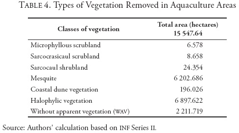
It should be noted, on the other hand, that the types of environments where scrubland is found as well as coastal dune vegetation do not represent significant cleared areas. The three representative classes in changes of land use are: mesquite (Prosopis spp.) with ironwood (Olneya tesota) and palo verde (Cercidium spp.), halophiles with chamizo [saltbush] (Atriplex spp.), and wav areas with flood-prone zones, identified in the field in areas surrounding farms. To verify the official information, a classification was made identifying vegetation before the clearing. Five spectral signatures corresponding to the types of environments corroborated in the field were analyzed (Table 5).
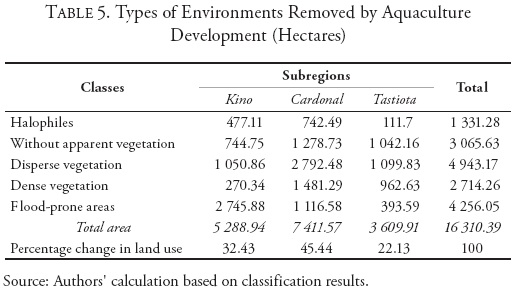
The results show changes in land use of 30.31 percent of the total of the aquaculture coverage in disperse vegetation environments, 26.09 percent in flood-prone areas, 18.8 percent in areas without apparent vegetation, 16.64 percent in places with dense vegetation, and 8.16 percent of areas with halophilic vegetation.3 The characteristics of each subregion are different; in Kino, for example, aquaculture areas predominate in flood-prone areas corresponding to 16.84 percent of the total; this indicates a high concentration of farms situated in areas of water retention surrounding La Cruz Estuary. In Cardonal, the changes occur in environments of disperse vegetation in an area of 17.12 percent of the total (away from Cardonal Estuary) and situated in places surrounded by coastal dune cordons. Nevertheless, in Tastiota the diversity of environments presents a more homogenous distribution, where ponds predominate in areas of disperse, dense, and without apparent vegetation that add up to 19.03 percent of the total area. The environment surrounding aquaculture development also responds to the process of transformation; in this case, shrimp farming modifies the surface hydrology by blocking existing runoff. Furthermore, it has a close relationship with water resources in its operative phase, where its territorial articulation with the marine environment generates the appropriation of an environmental benefit through water intakes and discharges (Map 2).
With the goal of doing the least harm, it is considered that the average distance between a discharge drain and a water intake is approximately 2.5 kilometers. In Kino, 704.5 hectares of ponds are supplied with water from La Cruz Estuary, while the rest (2 472.69 hectares) use beachfronts.4 In the Cardonal zone (8 662.9 hectares) the farms utilize the beachfront as an area of supply and discharge. In Tastiota, 2 974.577 hectares of ponds use the estuary as an area for drains and only 688.31 hectares use the open sea, while all the farms get their water supply directly from the sea.
Coastal Fisheries: Maritime Harvest and Variation of Species
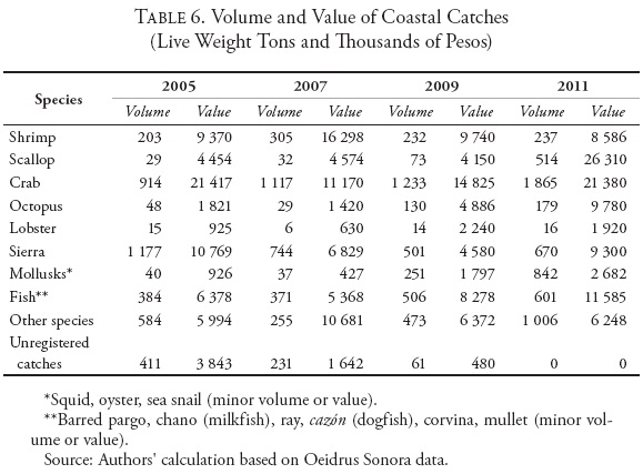
The extraction of marine fauna by coastal community fishermen is the third inductive factor. This activity is articulated in a complex manner with an accumulation of productive chains of the area of study and biological chains of the Gulf of California. Both form part of the Coast, being in the sphere of influence of the productive aquaculture developments. To identify the productive environment of the coastal dwellers it was necessary to analyze the volume of the catch, of which variations were identified that—in the opinion of the fishermen—represent the principal indicator of its critical context. The most representative species caught are crustaceans such as crab and shrimp; scallop and sea snail in the mollusk family; and, in scaled fish, mackerel (sierra) and mullet (lisa).
Crab figures as the harvested species of greatest importance, as from 2006 to 2011 8 021 tons were caught, with oscillating rates of growth of 17.2 percent on average. Its catch volume represents 28.91 percent of the total of the harvested species of the region. During the same period, the fishing of mackerel had an important harvest of 5 665 tons with positive rates of growth of 69.3 percent on average; this represents 20.42 percent of the total of harvested species (Table 6).
According to information from the fishermen, the increase in fishing boats has represented one of the principal elements in relation to the variations in the fishing catch. This increase forms part of the set of internal factors of organization and operating guidelines, as well as environmental externalities and intersectoral conflicts, in which the regulation established by the official authorities on the basis of biological studies that estimate the stocks of species and the fishing effort stands out (Graph 1).
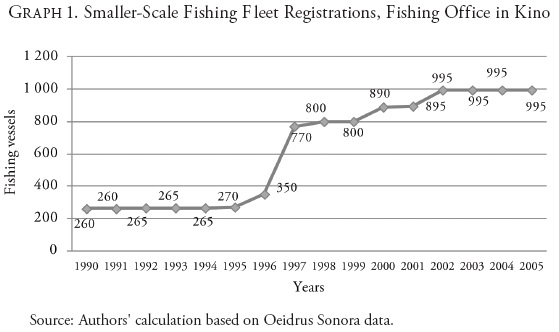
In the mid-1990s, there were 270 fishing vessels in the region, while in later years the number grew 229 percent to point of reaching 890 vessels in 2000. After that, growth was only 11.79 percent, reaching 995 coastal fishing vessels in 2005. According to local authorities, the number of authorized vessels have has not varied in recent years; nevertheless, this figure may not match the true total due to the increase in independent fishermen whose activity is unregulated. This context of the existence of a fishing effort outside the parameters regulating the productive and biological arena may affect the data. Thus, it follows that species of interest are those that have an evident presence in the market and represent an important commercial value when harvested.
TERRITORIAL CHANGES AND SOCIAL RESPONSES
Coastal Ejidos: Reduction in Spaces, Prolongation of Utilizations, and New Local Activities
The dynamic of territorial growth of the ejidos presents significant variability in the function of the productive context. From 1983 to 1986 the pasture area remained constant at 26 262.639 hectares. Subsequently, in 1990, it grew when the Puerto Arturo ejido was formed, reaching 33 048.82 hectares in the entire coastal strip. Beginning in 2000 and in the face of the agrarian regularization process, the ejido area fell. At the same time, the ejidos reduced their territorial participation upon selling a significant portion of the areas they utilized. In 2008, the pastures totaled 27 563.19 hectares; just between 2008 and 2010, their area showed a difference of 16 130.84 hectares (Graph 2).
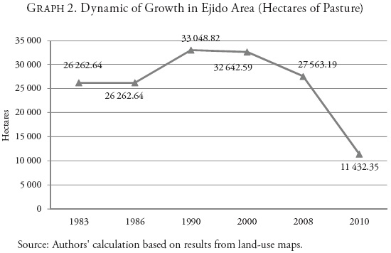
According to information obtained in the field, all the reduction in the area of the ejidos became shrimp farms. At the regional level, the aquaculture projects increased their presence in the face of productive expectations promoted by the state. In the face of this scenario, the ejido situation presented vulnerability through wood overharvesting, the regional agricultural crisis, environmental adversity, and strong migration. The sale of lands meant a strategy of immediate survival in response to the local-regional crisis, which brought about a reconfiguration of the social fabric of the coastal communities, being made up of ejidatarios who sold their lands and opted to migrate on the one hand, and on the other, ejidatarios who managed to stay in the settlements, dealing with adversities and territorial change.
The specific analysis of the ejidos indicates the presence of a set of socio-productive elements that show how they respond to the aquaculture context. Five factors that intervene in the current scenario were grouped together: pasture condition, productive activity, population level, ejido organization, and association with aquaculture projects. In the majority of the pastures where charcoal activity remains active, a damaged ecological environment has been registered as a result of excessive wood harvesting, adverse environmental conditions, and the increase in aquaculture land-use changes. Nevertheless, recovery in the San Juan y El Pinito and Puerto Arturo ejidos is seen as a result of their abandoning charcoal activity, returning to small-scale livestock production, and the application of mitigation measures because of a shortage of precipitation. Also, the construction of embankments in pastures for water retention in zones where vegetation can grow is seen. Even when in some cases the ejidatarios have taken mitigation measures or use livestock, the conditions stay the same and the overharvesting of wood translates into a search for immature species to cut or in resorting to the extraction of mesquite roots (Table 7).
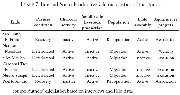
Half of the ejidos maintain active organizations, reflected in the monthly meetings of ejido assemblies, which provide a space for analysis and discussion of the internal situation of the community; furthermore, it gives them the right to participate in the decision-making in a collective manner. Indeed, the ejidos that have developed an association with the shrimp farms are those that have kept their ejido assemblies active; their organization has allowed them to strengthen their social capital. Their inclusion in aquaculture production responds to extensive processes of negotiation and of the influence of moral leaders who have propitiated levels of trust and social cohesion between all the inhabitants. The perseverance of key social actors, solid organization, and the shunning of land-sale of fers have facilitated a beneficial partnership framework with the aquaculture farms in keeping with the territorial change. Both the Puerto Arturo as well as the San Juan y El Pinito ejidos have income that comes from the productivity of shrimp farms, maintaining a part of the pasture with livestock production and offering some services to the aquaculture projects. In contrast, the ejidos that do not hold assemblies are characterized by being communities excluded from the productive context, with strong migratory processes and living of fincome obtained outside the ejido. The territorial changes have placed them in a situation of extreme vulnerability that little by little has fragmented their social cohesion to the point of reducing their possibilities of articulating with the aquaculture context. Their characteristics include deteriorated pasture conditions, prolonged charcoal activity, and the impossibility of maintaining their internal organization due to an accelerated reduction in the number of ejidatarios.
Shrimp Farming: Intensive Territorial Production and Viral Threats
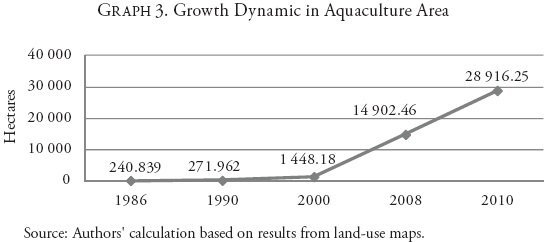
The dynamic of growth of the aquaculture area developed as the territorial suitability, technological availability, regulation of ejido land tenancy, and government support allowed a favorable context for investment. This utilization was subject to the types of environments propitious for the construction of ponds and the possibility of recreating water environments in land areas.5 Spatial identification shows how the increase in ponds occupies both ejido areas and land without apparent use in the coastal strip. In the Tastiota area from 1986 to 1990 there were only 271.96 hectares of ponds, which had a direct relationship with the estuary. From 1990 to 2000, the area occupied by ponds was 1 448.18 hectares in the area of El Pinito and Kino Viejo. The most accelerated growth of the shrimp farms was recorded in the 2000-2010 period, in which the activity came to occupy almost 29 000 hectares and maintains an extensive profile (Graph 3).
Under this scenario, a productive base was generated whose owners invested in pumping mechanisms and water circulation systems that the physical growth of the activity benefited from. The technological improvement allowed them to establish themselves a little farther away from the coastline, optimizing the total area, with the aquaculture suitability of the coastal strip and the reduction in production costs this brings about. Furthermore, the health environment of the region was positive, in contrast with the experiences of the aquaculture parks in the south of Sonora. Everything seems to indicate that the water circulation systems used in the area of study brought about a safe environment that buf fered the region's health problems. As a result, the social responses of the producers translated into an increase in aquaculture ponds, and, later, into the intensification of the activity upon saturating the spaces that had productive suitability.
If the yield per hectare remained constant (with minimal oscillations of four tons), with the passage of time the expectations of growth diminished. As the ponds increased and the activity intensified, the aquaculture harvest declined as a consequence of the surge in various diseases (Graph 4).
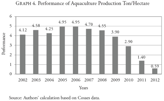
During the period of greatest growth of the aquaculture farms (2006-2007), health authorities recorded the existence of viruses affecting ponds (NHP and TSV) whose effects at that moment were not enough for a health risk zone to be declared. Nevertheless, it was not until the spread of white spot syndrome virus (WSSV) in 2008 that a critical context arose that caused a reassessment of a scenario and environment that in its beginnings had been seen as an optimal one for the resistance of pathogens (Table 8).
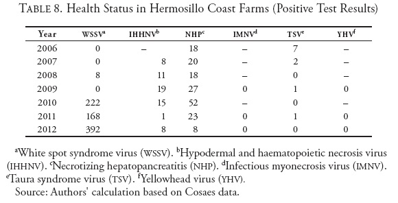
Thus, from that date, the situation has tilted toward a vulnerable production environment, as, according to the farms' producers and technicians, the mortality percentages of the harvests have been growing. The critical environment of pathogenesis is composed of the following elements: noncompliance with health norms, inappropriate cultivation densities, unchecked growth of the number of aquaculture units, short distances between water intakes and discharges, reduction in seed quality, and lack of an academic relationship with the scientific community for the analysis of the activity.
Therefore, the territorial change can be interpreted as a product of accelerated growth of the farms, the saturation of the spaces, and the appearance of viral diseases as a threat to economic sustainability. The breaking point of shrimp farmers was taken advantage of by the large aquaculture complexes that increased their physical space with the purchase or rental of farms in critical situations. The social responses of the active shrimp farmers translated into an increase in technological mitigation measures to confront the health context, at the same time attempting to regulate the increase in their costs of production.
Coastal Communities: Social and Ecological Resilience
To keep their productive development going, the coastal communities tend to adopt social and ecological resilience as needed when the ecosystems modify their production.6 In general, all the fishermen of the zone say the aquaculture farms have contributed to the variation in the species of commercial interest that they catch. The development of shrimp farming is seen as the inductive element putting the most pressure on the coastal strip to generate synergies in all fishing areas. Its intervention through the construction and operation of water intakes and drains is seen as a central element of competition between coastal fishermen. Furthermore, elements of controversy stand out, such as positions taken about their implications in estuary systems (eutrophication, sedimentation, loss of depth) and in beachfronts, accompanied by fauna that results from hydrological works and their possible effects on species of commercial interest, which support the coastal dwellers. In this sense, the sedimentation of the estuaries, principally in Tastiota, and to a lesser extent in La Cruz, reflects the friction between the fishing subsectors.
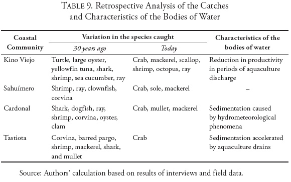
It should be noted, nevertheless, that the fishermen of the zone have ambivalent feelings about the implications of shrimp farming. For some, the productive, environmental, and territorial changes have negatively affected their fishing areas, while others see a benefit in the possible recovery of other fisheries, which they would take advantage of and commercialize, as in the case of crab. Indeed, today, this species of commercial interest is the uniform utilization factor in all the communities; most of the fishermen depend on it (Table 9). Its productive cycle has allowed them to stay in business despite the scarce availability of other species that could be commercialized, particularly in the area of Cardonal and Tastiota. However, the dependence on crab has increased a situation of risk as a result of the set of utilizations where they compete for space and environmental benefits that emanate from the marine ecosystems.
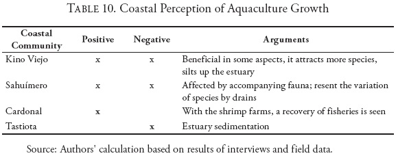
This issue, nevertheless, has not stopped fishermen from developing a more comprehensive and systematic perception about their ecological and productive context, which no doubt has something to do with their capacity for resilience. That has allowed them to construct a more holistic vision of their environment and identify each one of the utilizations with which they compete as part of a greater ecological complexity, articulated with a set of inevitable food chains; they consider causes and consequences, and decide what their forms of action will be. Their empirical knowledge causes them to exercise a species of "socio-ecological rationality," which allows them to raise their awareness of the workings of the ecosystem and continue fishing (Table 10).
CONCLUSION: CYCLICAL TRANSFORMATION OF THE REGION AND DEVELOPMENT OF TERRITORIAL SYNERGIES
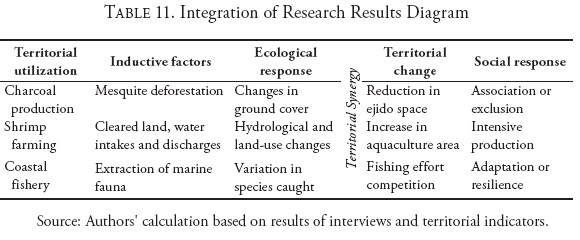
Through different processes of territorial appropriation (Giménez and Héau, 2007; Toledo, 2008), the regional transformation of the Coast has brought about a set of productive activities seen as inductive factors situated in various periods. Each one of them affects ecological and social scales (Gómez, 2007; Castro, 2008) in the complexity that emanates from the coastal environments (Castillo, Ulloa and Alvarado, 2009; Breton, 2001). The first element is considered to be a scenario of depletion, where agriculture, through the over-exploitation of the aquifer, unleashed a set of repercussions, both economic and ecological, in the entire region (Moreno, 2006; Castellanos et al., 2009; Martínez, 1998). Slowly a territorial imbalance was generated that reconfigured the environment through the intensification of traditional activities in coastal communities and ejidos (Sedesol, 2011; Inapesca, 2012). At the same time, it fostered the expectations of development of new productive activities situated in the land limits of the region through aquaculture production (Nava, 2003). Thus, the Hermosillo Coastal strip is considered to be the last link in an ecological-productive transition, which brings together various inductive factors in a dynamic of ambivalent development subject to territorial synergies. This scenario includes the growth of shrimp farming as a pole of economic attraction, which shares territorially with less-productive activities such as coastal fishing and ejido charcoal production to develop areas of utilization (Table 11).
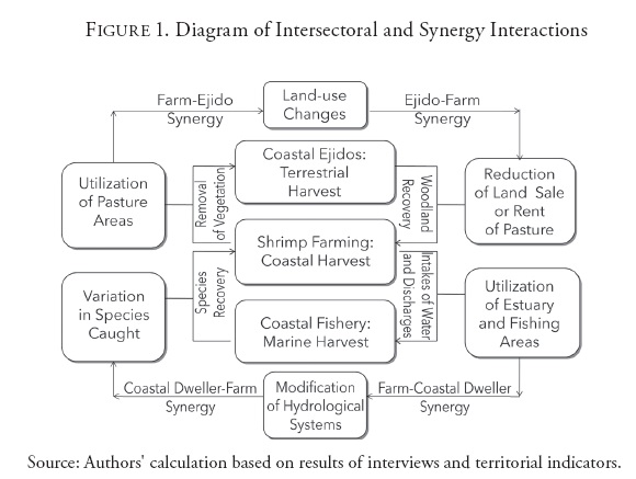
The results throughout this work show that each inductive factor in the coastal strip has generated a different ecological response. Its contribution to the process of regional transformation is placed in a context that had begun in earlier decades through agriculture and the changes in the upper part of the Sonora River basin (Salazar, Moreno and Lutz, 2012). The processes of desertification in the ejido pastures, the land-use changes and the modification of the surface hydrology in aquaculture areas, as well as the biological implications of the increase in the fishing effort, figure as part of the response of the resource to the shocks that each utilization induces. As the increase in aquaculture has had a more intense territorial participation, its implications have also been greater in comparison with those that the rest of the utilizations have caused. It could be said that shrimp farming reflects a kind of "economic rationality on a greater scale," now that its incipient expectations were directed at the physical growth in the entire coastal strip to the point of exhausting the land suitable for it. Once again, the current perspective of the region is placed in a process of cyclical transformation of the territory, where all the utilizations respond to the same factor of ecological depletion existent since the formation of the Hermosillo Coast. This indicates that there has never been an economic activity exempt from an over-utilization of natural resources (Figure 1).
From the approach of ecology, the territories manage to regulate themselves in the face of various shocks emanating from physical external factors (Margalef, 1977; Colinvaux, 1995); nevertheless, the continued utilization of the benefits nature provides conflicts with this condition of regulation. In the social scale, the synergy between inductive factors intercedes in utilizations linked to a shared territory (Gómez, 2007; Cerdan, Aquilante and Freire, 2011), each one responding to them in a distinct manner according to the complexity of the context. In general, the Hermosillo Coast is tied to a region with accumulated ecological impacts, incapable of sustaining it selfin a harmonious manner with the environment in the long run, with productive cycles that leave a reduced portion of beneficiaries upon concluding their interval. Everything seems to indicate that the possibility of generating a new productive scenario is uncertain; that depends both on scientific development and the vision of territorial utilization that social actors organize, both of which must take into account the ecological implications of the region, such as the continued detriment of the activities that survive to a context of adversities herein described.
REFERENCES
Boisier, Sergio, 2010, "Descodificando el desarrollo del siglo XXI. Subjetividad, complejidad, sinapsis, sinergia, recursividad, liderazgo y anclaje territorial," Semestre Económico, vol. 13, no. 27, July-December, pp. 11-37. [ Links ]
Breton, Yvan, 2001, "Ciencias sociales y manejo costero: De las construcciones ideológico-sociales y acciones concretas," Estudios Sociales, vol. 11, no. 21, pp. 11-24. [ Links ]
Cabazos, Raúl, 1997, "Uso múltiple de los agostaderos en el norte de México," Ciencia Forestal en México, vol. 22, no. 81, January-June, [ Links ]
Castellanos, Alejandro; Luis Bravo, George Koch, José Llano, Deladier López, Romeo Méndez, Julio Rodríguez, Raúl Romo, Thomas Sisk and Gertrudis Yanes, 2009, "Impactos ecológicos por el uso del terreno en el funcionamiento de ecosistemas áridos y semiáridos," in Francisco E. Molina-Freaner and Thomas R. Van Devender, eds., Diversidad biológica del estado de Sonora, Mexico City, Universidad Nacional Autónoma de México, pp. 157-186. [ Links ]
Castillo, Sergio; Raúl Ulloa and Dulce Alvarado, 2009, Regionalización en base a indicadores ambientales en cuatro áreas marinas de México. Informe final a la Red Iberoamericana de Ecosistemas, Nayarit, Mexico, Universidad Autónoma de Nayarit. [ Links ]
Castro, María Eugenia, 2008, "Teorías de la relación sociedad-naturaleza en los territorios. Propuesta desde el marxismo ecológico y el enfoque de la complejidad," in Blanca Rebeca Ramírez Velázquez, ed., Formas territoriales. Visiones y perspectivas desde la teoría, Mexico City, Universidad Autónoma Metropolitana. [ Links ]
Cerdan, Claire; Mariana Aquilante Policarpo, and Paulo Freire Vieira, 2011, "Sinergias y conflictos entre dinámicas territoriales: Rumbo al desarrollo sustentable en la zona costera del Estado de Santa Catarina-Brasil," Santiago de Chile, Programa Dinámicas Territoriales Rurales/Centro Latinoamericano para el Desarrollo Rural-Rimisp (Working Paper, no. 96). [ Links ]
Colinvaux, Paul, 1995, Introducción a la ecología, Mexico City, Limusa/Noriega. [ Links ]
Delgado, Claudia [bachelor's thesis], 2003, El lado terrestre de las mareas: Grupos domésticos de pescadores en Bahía Kino, Sonora, Chihuahua, Mexico, Escuela de Antropología e Historia. [ Links ]
Dewalt, Billie R.; Jaime Renán Ramírez, Lorena Noriega, and Rosa Esthela González [report], 2002, Shrimp Aquaculture, the People and the Environment in Coastal Mexico, s. l., The World Bank/NACA/WWF/FAO/Consortium Program on Shrimp Farming and the Environment. [ Links ]
Doode, Shoko, and Pablo Wong-Gonzalez, 2001, "El Golfo de California: Surgimiento de nuevos actores sociales, ambientalismo y región," Estudios Sociales, no. 21, January-June, pp. 25-56. [ Links ]
Giménez, Gilberto, and Catherine Héau, 2007, "El desierto como territorio, paisaje y referente de identidad," Culturales, Universidad Autónoma de Baja California, vol. 3, no. 5, January-June. [ Links ]
Gómez, Domingo, 2007, Ordenación territorial, 2nd ed., Madrid, Mundi-Prensa. [ Links ]
Iinstituto Nacional de Pesca (INAPESCA), 2012, Carta Nacional Pesquera 2012, Diario Oficial de la Federación, Mexico City, Sagarpa, tome DCCVII, no. 18, August 24, 2nd and 3rd section, pp. 21-128. [ Links ]
Luers, Amy; Rosamond Naylor, and Pamela Matson, 2005, "A Case Study of Land Reform and Coastal Land Transformation in Southern Sonora, Mexico," Land Use Policy, vol. 23, no. 4, pp. 436-447. [ Links ]
Madrid, Norma, 2003, "Mecanismos de generación de capital social en programas gubernamentales de desarrollo en Venezuela," Capital social: Clave para una agenda integral de desarrollo, Caracas, Corporación Andina de Fomento. [ Links ]
Margalef, Ramón, 1977, Ecología, Barcelona, Omega. [ Links ]
Martínez, María Jesús [master's thesis], 1998, "Sucesión en campos de cultivo abandonados en la región agrícola de la Costa de Hermosillo: Fisiología ecológica de las especies vegetales dominantes durante la sucesión e implicaciones para la restauración," Ensenada, Mexico, Facultad de Ciencias-Universidad Autónoma de Baja California. [ Links ]
Miranda, Anselmo [monograph], 2004, La acuicultura y su entorno productivo, ambiental, socioeconómico y normativo, Ensenada, Mexico, Departamento de Acuicultura-CICESE. [ Links ]
Montemayor, Gabriela, and Raúl Molina, 2002, "Identificación de recursos importantes en la pesca ribereña de la parte central de Sonora," Memorias I Foro Científico de Pesca Ribereña, Guaymas, Mexico, INP/CRIP, October 17-18. [ Links ]
Moreno, José Luis, 2006, Por abajo del agua. Sobreexplotación del acuífero de la costa de Hermosillo, 1945-2005, Hermosillo, Mexico, El Colegio de Sonora. [ Links ]
Moreno Rivera, César, Amy Hudson Weaver, Luis Bourillón Moreno, Jorge Torre Cosío, Janitzio Égido Villareal y Mario Rojo Amaya, 2005, "Diagnóstico ambiental y socioeconómico de la región Marina-Costera de Bahía de Kino/Isla Tiburón, Sonora, México: Documento de trabajo y discusión para promover un desarrollo sustentable," Guaymas, Mexico, Comunidad y Biodiversidad. [ Links ]
Nava Aybar, Alejandro [master's thesis], 2003, "Evaluación del potencial de desarrollo camaronícola en la región costera de Bahía Kino-Tastiota, Sonora," Hermosillo, Mexico, DCITUS-Universidad de Sonora. [ Links ]
Ostrom, Elinor, 2000, El gobierno de los bienes comunes. La evolución de las instituciones de acción colectiva, Mexico City, Fondo de Cultura Económica. [ Links ]
Páez, Federico, 2005, "Retos y perspectivas de la camaronicultura en la zona costera," Revista Latinoamericana de Recursos Naturales, no. 1, pp. 21-31. [ Links ]
Ramírez, Carlos [master's thesis], 2010, Evaluación de la gestión ambiental sobre la actividad acuícola en el municipio de Guasave, Sinaloa, Tijuana, Mexico, El Colef/CICESE. [ Links ]
Ramos, Juan, 1989, "Historia de un coctel: Camaronicultura vs camarón y cultura," Memoria: XIII Simposio de Historia y Antropología de Sonora, Hermosillo, Mexico, Instituto de Investigaciones Históricas-Universidad de Sonora, vol. 2. [ Links ]
Rescia, Alejandro; Sara Fungariño, and John Dover, 2010, "Reactivación del sistema socioecológico ganadero de Picos de Europa (norte de España)," Ecosistemas, vol. 19, no. 2, pp. 137-145, May. [ Links ]
Rodríguez, José; Diana Crespo, and María López, 2010, La camaronicultura y la sustentabilidad del Golfo de California, WWF Programa Golfo de California. [ Links ]
Rosas, José [forestry science bachelor's thesis], 1992, La producción de carbón vegetal en el estado de Sonora, Chapingo, Mexico, Universidad Autónoma de Chapingo. [ Links ]
Salazar, Alejandro; José Luis Moreno, and América Lutz, 2012, "Agricultura y manejo sustentable del acuífero de la Costa de Hermosillo," Región y Sociedad, no. 3. [ Links ]
Secretaría de Desarrollo Social, 2011, Diagnóstico situacional del poblado Miguel Alemán, Hermosillo, Mexico, Coordinación Estatal de Microrregiones-Sedesol Sonora, April. [ Links ]
Secretaría de Medio Ambiente y Recursos Naturales, 2006, Diagnóstico de los problemas más intensos localizados en las UGAS de interés prioritario en el Golfo de California, Mazatlán, Mexico, Ordenamiento Ecológico Marino del Golfo de California. [ Links ]
Szauer, María, and Silvia Castillo, 2003, "Capital social: Articulador del desarrollo sostenible," Capital social: Clave para una agenda integral de desarrollo, Caracas, CAF. [ Links ]
Toledo, Víctor, 2008, "Metabolismos rurales: Hacia una teoría económico-ecológica de la apropiación de la naturaleza," Revista Iberoamericana de Economía Ecológica, no. 7, pp. 1-26. [ Links ]
Young, Oran; Frans berkhout, Gilberto gallopin, Marco Janssem, Elinor Ostrom, and Sander Leeuw, 2006, "The Globalization of Socio-Ecological Systems: An Agenda for Scientific Research," Global Environmental Change, vol. 16, no. 3, pp. 304-316. [ Links ]
* Text and quotations originally written in spanish.
1 Mesquite scrubland (Prosopis spp.) has the presence of ironwood (Olneya tesota) and palo verde (Cercidium spp.). The class "without apparent vegetation and not applicable" was grouped together as areas without the presence of vegetation and anthropogenic character. Scrubland includes: crasicaul, microphyllous scrubland, sarcocrasicaul, and sarcocaul. Halophiles include: mangrove, hydrophylic halophiles, and xerophytes.
2 The area occupied by aquaculture was digitized with an Aster 2010 satellite image. Considered in this analysis was the INF Series II, which did not address aquaculture areas and where the types of removed environments can be seen. infland-use classes were adjusted.
3 The types of vegetation correspond to saline vegetation, cacti, and mesquite in dense patches, scrubland zones in environments with disperse vegetation and without apparent vegetation; bare soils in zones of water retention and discharge of runoff.
4 There are currently no aquaculture projects that deposit their discharges out into the water; all use the beachfront for their drains.
5 The comparative advantages were the axis that propitiated an ad hoc environment for the requirements of the producers, as well as competitive improvements in technology.
6 Resilience is the property of a system to adapt to shocks of a varied nature in a context of continuous change, conserving its structure and functionality.

