


 nueva página del texto (beta)
 Inglés (pdf)
 Artículo en XML
 Referencias del artículo
 Enviar artículo por email
 Citado por SciELO
  Similares en
SciELO
Similares en
SciELO 
 Permalink
INTRODUCTION
Urbanization increases waste generation at a surprising rate (Dutta and Jinsart 2020). Waste management has suddenly become a new threat to the global sustainability agenda of the United Nations (UN) due to the population explosion (Aragaw et al. 2016, Sharma et al. 2021). Mexico is ranked among the 10 countries with the highest generation of municipal solid waste (MSW) worldwide, making its comprehensive waste management a great challenge, similar to other countries (Marín et al. 2012, Vera-Romero et al. 2014). More than 102 895 t of MSW are generated daily in Mexico; of these, 83.93% are collected, 9.63% are recycled, and 78.54% are confined at a final waste disposal site (FWDS). A Mexican generates almost one kilogram of MSW daily (SEMARNAT 2017).
Information on the management of FWDS in Mexico is unknown (Cárdenas-Moreno et al. 2021). However, 1881 FWDS were reported in 2010, of which 12.7% were classified as landfills and 87.3% as open-air dumps (INEGI 2010). Although there is no updated data on the FWDS of MSW, it is clear that the most common disposal method is in open-air dumps, which are the commonly used FWDS in less developed regions worldwide, such as Latin America and the Caribbean (Oakley and Jiménez 2012, Hettiarachchi et al. 2018, Margallo et al. 2019).
Open-air dumps are uncontrolled FWDS with waste indiscriminate confinement, limited control measures in their operation, a lack of recording of waste entered or incoming hazardous waste, and little or no inspection of operational requirements of tipping area, road maintenance, and surface water runoff. Furthermore, verifying engineered containment with clay or membrane liners, routine operation with compaction and daily cover, and leachate and biogas control are not practiced (Oakley and Jiménez 2012, Ferronato and Torretta 2019). The absence of control in FWDS represents a significant contamination source in most of the municipalities of Mexico, affecting mainly human health by the transmission of pathogen microorganisms to the components of the environment and causing soil erosion, surface water and groundwater pollution, and wind dispersion of pollutants (Marín et al. 2012, Nagarajan et al. 2012, Frączek et al. 2014, Powrie et al. 2021).
Geographic information systems (GIS) are a potential tool for analyzing satellite imagery used to assess FWDS concerning location restriction criteria or the degree of spatial disturbance, whether for active or abandoned FWDS. Various studies have demonstrated the usefulness of GIS in identifying FWDS with the potential for sustainable waste management or in analyzing the environmental impacts of their operation. Both actions provide information to government authorities for making decisions and taking actions to relocate FWDS to appropriate locations or to implement mitigation or prevention measures when the FWDS operation causes damage to the environment and the population (Saldaña-Durán and Nájera-González 2019, Ampofo et al. 2023, Araiza-Aguilar et al. 2023, Bhowmick et al. 2024, Saha and Roy 2024).
In Mexico, the Ley General para la Prevención y la Gestión Integral de los Residuos (General Law for the Prevention and Comprehensive Management of Waste), promulgated in 2003, establishes that the municipalities of each state are responsible for the collection and confinement of MSW, and they must own adequate spaces to allocate the wastes (SEMARNAT 2023). The Mexican Official Standard NOM-083-SEMARNAT-2003 (SEMARNAT 2004) was elaborated within the framework of this law and establishes environmental protection guidelines for site selection, design, construction, operation, monitoring, closure, and complementary works of an FWDS of MSW. Nevertheless, most FWDS frequently fail to fulfill the regulations, causing environmental and human health impacts. If the FWDS is not operated under controlled conditions, it could represent risks to human health and the environment.
The state of Zacatecas, Mexico, was taken as a case study. It has a territorial extension of 75 275.3 km2, 18% of the country’s surface area and is divided into 58 municipalities with a population of approximately 1.6 million in 2020 (INEGI 2020). Zacatecas is one of the five states that contribute less to gross domestic product (GDP) annually with < 1% (INEGI 2023c), which could reflect a recession or limitation in its economy. In 2010, 57 FWDS were reported for Zacatecas, of which 12.3% were called landfills and 87.7% were open-air dumps (INEGI 2010). However, the Secretaría de Agua y Medio Ambiente (Ministry of Water and Environment, SAMA) reported in 2023 that the FWDS in the 58 municipalities of Zacatecas were still open-air dumps (García 2023). This data was contradictory to that reported by INEGI (2010).
Nowadays, the amount of FWDS in operation is unknown by the SAMA, which pretends to minimize the environmental impacts caused by inadequate management of MSW in the municipalities of Zacatecas. However, the lack of human and financial resources to address this problem does not allow to have control over the FWDS or to improve comprehensive waste management, implement efficient methods of disposal, and verify that FWDS comply with all the guidelines stipulated by NOM-083-SEMARNAT-2003 (SEMARNAT 2004), currently in force.
Therefore, this work aimed to perform an inventory of FWDS in the state of Zacatecas, Mexico, and to assess their environmental compliance regarding site category, location restrictions, and operating conditions based on the guidelines of NOM-083-SEMARNAT-2003 (SEMARNAT 2004) and using GIS. This study attempts to demonstrate that most FWDS (more than 50%) operate under conditions outside the guidelines of Mexican environmental regulations. This situation would reflect the lack of sustainable waste management in Zacatecas and could be replicated in different states of Mexico or other cities worldwide. The information provided in this study will be valuable for governmental authorities since they can make decisions to prioritize and regulate the operating conditions of FWDS in Zacatecas, Mexico.
MATERIALS AND METHODS
The state of Zacatecas was selected as a case study due to the lack of knowledge about the issues of comprehensive waste management and mainly of FWDS in operation. This research was of a descriptive and quantitative type since it aimed to obtain an inventory of the existing FWDS in Zacatecas, identify the category of each site, and evaluate the location restrictions criteria and operating conditions regarding the guidelines established by NOM-083-SERMARNAT-2003 (SEMARNAT 2004). To do this, visits were carried out in each municipality, supported by SAMA and municipal authorities. The FWDS were identified, visited, and included in the inventory. Their location was recorded by GPS (Garmin Etrex 10) with UTM coordinate values and processed in ArcGIS Pro trial (v. 3.4) using INEGI databases (2023a, b) to represent their location on a map. It should be noted that not all identified FWDS have been officially authorized. However, they have been used as FWDS for years.
The environmental compliance assessment of the FWDS was conducted in accordance with the guidelines established by NOM-083-SERMARNAT-2003 (SEMARNAT 2004) regarding site category, location restrictions, and operating conditions. Table I presents the criteria and factors considered in the assessment, along with the information sources.
TABLE I CRITERIA CONSIDERED IN THE ENVIRONMENTAL COMPLIANCE ASSESSMENT OF THE FINAL WASTE DISPOSAL SITES (FWDS).
| Criteria | Factors | Sources |
| Site category |
|
|
| Location restrictions | Minimum distance from:
|
Assessment using datasets obtained from governmental portals such as Maderey-Rascón and Torres-Ruata (1990), IDEGEO (2012), CENAPRED (2021), INEGI (2021, 2022), CONAGUA/REPDA (2022), and CONABIO/CONANP (2024). |
| Operating conditions |
|
Field visits and checklist applications to FWDS operators. |
Estimating the factors of the site category was difficult since reliable official information does not exist. Governmental portals provided information, but it was insufficient or outdated, so conducting field visits in the study areas was essential to collect the data. FWDS operators provided information on the waste received daily (t/d). FWDS type was assigned according to table II and the operators’ data. The per capita generation of MSW was calculated by equation 1:
TABLE II CATEGORIES OF THE FINAL WASTE DISPOSAL SITES (FWDS) BASED ON NOM-083-SEMARNAT-2003 (SEMARNAT 2004).
| Category | Tonnage of waste received per day (t/d) |
| A | > 100 |
| B | 50-100 |
| C | 10-50 |
| D | < 10 |
The municipality’s population was obtained from INEGI (2020). The area of FWDS was estimated for geometry calculation using GIS tools. For this, field visits were conducted to record UTM coordinates using a GPS device (Garmin Etrex 10), which were necessary to delimit the FWDS area and to obtain a polygon. Then, they were recorded in a spreadsheet and processed in GIS.
Location restrictions were assessed using buffers as GIS tools. For each one of the restrictions, a buffer was determined based on the distance or restriction shown in table I. Then, it was added to a base map for processing the information in GIS under map overlay and transparency techniques. The datasets (metadata shapefile) were obtained from Maderey-Rascón and Torres-Ruata (1990)) and governmental portals such as IDEGEO (2012), CENAPRED (2021), INEGI (2021, 2022), CONAGUA/REPDA (2022), and CONABIO/CONANP (2024). The analyzed information was presented in maps to visualize the geographic distribution of the FWDS and determine their compliance with the Mexican Official Standard.
NOM-083-SERMARNAT-2003 (SEMARNAT 2004) establishes that FWDS must work with the operating conditions shown in table I. The Standard defines FWDS as a controlled site when it complies with the operating conditions, except for the design of a waterproofing system, and an uncontrolled site when it does not comply with one or more conditions. Therefore, the FWDS were assessed and classified according to the criteria of these two categories through field visits, information provided by FWDS operators, and a checklist of operating conditions.
Finally, percentages of each type of FWDS category, degree of accomplishment per location restriction criterion, and operating conditions concerning all inventoried FWDS were obtained. FWDS were prioritized based on compliance with the Mexican Official Standard. This prioritization would enable government authorities to determine how to act in the short, medium, and long term to regulate FWDS operations or close those with a significant impact on human health and the environment.
RESULTS AND DISCUSSION
FWDS inventory
Figure 1 shows the 58 municipalities of the state of Zacatecas, Mexico, and the 53 FWDS identified. Figure 2 shows the FWDS by region: northern, central, southern, and southeastern. One of the municipalities, El Salvador, does not have a FWDS. Therefore, the population of this city engages in practices that negatively impact the environment and human health, such as uncontrolled waste burning or disposing of garbage in clandestine dumps. However, these practices are widespread in the communities of Zacatecas and throughout the country (Aguilera-Flores et al. 2021).
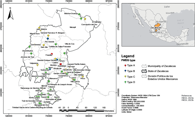
Fig. 1 Municipalities of the state of Zacatecas, Mexico, and final waste disposal sites (FWDS) by type.
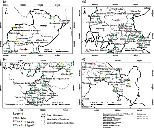
Fig. 2 Final waste disposal sites (FWDS) by type in Zacatecas: (a) northern region, (b) central region, (c) southern region, (d) southeastern region.
The city of Zacatecas has an inter-municipal FWDS, which shares with the adjacent municipalities of Guadalupe and Morelos, as well as the municipalities of Vetagrande and Trancoso, adjacent to Guadalupe. The FWDS was named “JIORESA,” an abbreviation for Junta Intermunicipal para la Operación del Relleno Sanitario (Intermunicipal Board for the Landfill Operation). Regarding the site category based on NOM-083-SEMARNAT-2003 (SEMARNAT 2004), two Type A FWDS (red color), three Type B FWDS (blue color), 17 Type C FWDS (yellow color), and 31 Type D FWDS (green color) were identified (Figs. 1 and 2).
Table III shows the municipality’s population obtained from INEGI (2020), the amount of waste received daily provided by FWDS operators, the per capita generation of MSW calculated by equation 1, and the area occupied by waste disposal (available area) for the municipalities of Zacatecas.
TABLE III MUNICIPALITY’S POPULATION, AMOUNT OF WASTE RECEIVED DAILY, AND PER CAPITA GENERATION OF MUNICIPAL SOLID WASTE (MSW) FOR THE MUNICIPALITIES OF ZACATECAS, MEXICO.
| Municipality | Municipality’s population | Amount of waste received daily (t/d) | Per capita generation of MSW (kg/inhabitants/d) | Available area (ha) |
| Apozol | 6260 | 3.0 | 0.4792 | 1.85 |
| Apulco | 4942 | 1.6 | 0.3238 | 1.00 |
| Atolinga | 2277 | 7.7 | 3.3816 | 1.86 |
| Benito Juárez | 4493 | 5.5 | 1.2241 | 2.17 |
| Calera | 45 759 | 62.0 | 1.3549 | 2.17 |
| Cañitas de Felipe Pescador | 8255 | 6.6 | 0.7995 | 1.66 |
| Chalchihuites | 10 086 | 4.4 | 0.4362 | 2.41 |
| Concepción del Oro | 12 115 | 10.4 | 0.8584 | 2.41 |
| Cuauhtémoc | 13 466 | 13.0 | 0.9654 | 4.85 |
| El Plateado de Joaquín Amaro | 1579 | 0.5 | 0.3293 | 0.45 |
| El Salvador | 2509 | INA | INA | INA |
| Fresnillo | 240 532 | 121.0 | 0.5031 | 11.15 |
| Genaro Codina | 8168 | 4.4 | 0.5387 | 1.81 |
| General Enrique Estrada | 6644 | 22.0 | 3.3113 | 3.82 |
| General Francisco R. Murguía | 20 191 | 11.0 | 0.5448 | 1.51 |
| General Pánfilo Natera | 23 526 | 22.0 | 0.9368 | 3.02 |
| Huanusco | 4547 | 1.1 | 0.2419 | 0.69 |
| Jalpa | 25 296 | 8.8 | 0.3483 | 8.74 |
| Jerez | 59 910 | 57.0 | 0.9514 | 13.54 |
| Jiménez del Teul | 4465 | 3.3 | 0.7391 | 0.36 |
| JIORESA | 405 285 | 154.0 | 0.3800 | 9.83 |
| Juan Aldama | 19 749 | 18.0 | 0.9114 | 5.12 |
| Juchipila | 12 251 | 21.0 | 1.7141 | 1.56 |
| Loreto | 53 709 | 28.0 | 0.5213 | 0.80 |
| Luis Moya | 13 184 | 7.1 | 0.5363 | 4.15 |
| Mazapil | 17 774 | 3.3 | 0.1857 | 0.83 |
| Melchor Ocampo | 2736 | 1.1 | 0.4020 | 0.30 |
| Mezquital del Oro | 2451 | 1.7 | 0.6732 | 0.84 |
| Miguel Auza | 23 713 | 18.0 | 0.7591 | 8.77 |
| Momax | 2446 | 3.3 | 1.3491 | 0.61 |
| Monte Escobedo | 8683 | 6.6 | 0.7613 | 2.41 |
| Moyahua de Estrada | 4530 | 3.3 | 0.7285 | 0.73 |
| Nochistlán de Mejía | 27 945 | 44.0 | 1.5745 | 4.85 |
| Noria de Ángeles | 16 284 | 5.5 | 0.3384 | 0.87 |
| Ojocaliente | 44 144 | 28.0 | 0.6343 | 6.45 |
| Pánuco | 17 577 | 7.7 | 0.4386 | 5.17 |
| Pinos | 72 241 | 24.0 | 0.3322 | 3.21 |
| Río Grande | 64 535 | 88.0 | 1.3636 | 8.08 |
| Sain Alto | 21 844 | 11.0 | 0.5036 | 4.83 |
| Santa María de la Paz | 2767 | 2.0 | 0.7156 | 0.64 |
| Sombrerete | 63 665 | 25.0 | 0.3927 | 1.41 |
| Susticacán | 1365 | 0.2 | 0.1612 | 0.24 |
| Tabasco | 16 588 | 8.8 | 0.5311 | 4.41 |
| Tepechitlán | 8321 | 6.6 | 0.7944 | 0.81 |
| Tepetongo | 6490 | 9.9 | 1.5285 | 3.04 |
| Teúl de González Ortega | 5356 | 6.6 | 1.2229 | 0.87 |
| Tlaltenango de Sánchez Román | 27 302 | 20.0 | 0.7325 | 5.35 |
| Trinidad García de la Cadena | 3362 | 4.4 | 1.3087 | 2.08 |
| Valparaíso | 32 461 | 42.0 | 1.2939 | 1.88 |
| Villa de Cos | 34 623 | 8.8 | 0.2545 | 2.13 |
| Villa García | 19 525 | 2.2 | 0.1127 | 4.10 |
| Villa González Ortega | 13 208 | 8.8 | 0.6670 | 1.64 |
| Villa Hidalgo | 19 446 | 2.2 | 0.1131 | 1.52 |
| Villanueva | 31 558 | 27.0 | 0.8556 | 5.98 |
*JIORESA includes the municipalities of Guadalupe (211 740 inhabitants), Morelos (13 207 inhabitants), Trancoso (20 455 inhabitants), Vetagrande (10 276 inhabitants), and Zacatecas (149 607 inhabitants).
INA: information not available.
It can be noted in table III that the amount of waste received daily ranges from 0.2 t/d (Susticacán municipality) to 154 t/d (Guadalupe, Morelos, Trancoso, Vetagrande, and Zacatecas municipalities), averaging 19.1 t/d of disposed waste in the 53 FWDS identified within the state of Zacatecas. Likewise, per capita generation of MSW ranges from 0.1127 kg/inhabitants/d (Villa García municipality) to 3.3816 kg/inhabitants/d (Atolinga municipality) with an average of 0.8124 kg/inhabitants/d). Susticacán is the municipality with the lowest FWDS area, and Jerez has the highest FWDS area (Table III).
A per capita generation of 0.944 kg/inhabitants/d was reported in 2017 for the western region of the country, including the states of Aguascalientes, Colima, Guanajuato, Jalisco, Michoacán, Nayarit, Querétaro, San Luis Potosí, and Zacatecas (SEMARNAT 2020). The value reported by SEMARNAT (2020) was 1.16 times higher than the average value estimated in this study (0.8124 kg/inhabitants/d). Although there is a tendency for per capita generation to increase over time (SEMARNAT 2017), the value obtained in this work is close to the true value, as Zacatecas is one of the five states that contributes the least to the gross domestic product (INEGI 2023c). MSW generation is directly linked to a society’s purchasing power and economic growth (Vyas et al. 2022). Additionally, it should be noted that the FWDS receives MSW only from the municipal seat and surrounding communities, resulting in 100% coverage of waste disposal only for these areas, as the entire municipal territory is not served (Aguilera-Flores et al. 2021).
Assessment of FWDS location restrictions
The FWDS must comply with the location restrictions shown in table I. Table IV summarizes each FWDS’ compliance with location restrictions. Figures S1 to S53 in the supplementary material show the maps generated with the location restrictions for the 53 FWDS identified in the state of Zacatecas.
TABLE IV FINAL WASTE DISPOSAL SITES’ COMPLIANCE WITH LOCATION RESTRICTIONS.
| Municipality | Airfields and airports (> 13 km) | Localities with more than 2500 inhabitants (> 500 m) | Surface water bodies (> 500 m) | Public supply wells (> 500 m) | Outside Natural Protected Areas | Outside wet ecosystems, plains, and aquifer recharge areas | Outside geological faults and fractures | Outside flood zones | Figure |
| Apozol | √ | √ | × | × | √ | √ | √ | × | S1 |
| Apulco | √ | × | × | √ | √ | √ | √ | × | S2 |
| Atolinga | √ | √ | √ | × | √ | √ | √ | × | S3 |
| Benito Juárez | √ | √ | × | √ | √ | √ | √ | × | S4 |
| Calera | × | √ | × | × | √ | √ | √ | × | S5 |
| Cañitas de Felipe Pescador | √ | √ | × | √ | √ | √ | √ | × | S6 |
| Chalchihuites | √ | √ | √ | × | √ | √ | √ | × | S7 |
| Concepción del Oro | √ | √ | × | √ | √ | √ | √ | √ | S8 |
| Cuauhtémoc | √ | √ | × | √ | √ | √ | √ | × | S9 |
| El Plateado de Joaquín Amaro | √ | √ | √ | √ | √ | √ | √ | √ | S10 |
| El Salvador | INA | INA | INA | INA | INA | INA | INA | INA | INA |
| Fresnillo | √ | √ | × | × | √ | √ | √ | √ | S11 |
| Genaro Codina | √ | √ | × | √ | √ | √ | √ | × | S12 |
| General Enrique Estrada | √ | √ | × | √ | √ | √ | √ | × | S13 |
| General Francisco R. Murguía | √ | √ | √ | √ | √ | √ | √ | × | S14 |
| General Pánfilo Natera | √ | √ | √ | √ | √ | √ | √ | × | S15 |
| Huanusco | √ | × | × | × | √ | √ | √ | × | S16 |
| Jalpa | √ | √ | × | × | √ | √ | √ | √ | S17 |
| Jerez | √ | √ | × | × | √ | √ | √ | × | S18 |
| Jiménez del Teul | √ | × | × | √ | √ | √ | √ | × | S19 |
| JIORESA | √ | √ | × | √ | √ | √ | × | √ | S20 |
| Juan Aldama | √ | √ | √ | × | √ | √ | √ | × | S21 |
| Juchipila | √ | √ | × | √ | × | √ | √ | × | S22 |
| Loreto | √ | √ | √ | √ | √ | √ | √ | √ | S23 |
| Luis Moya | √ | √ | √ | √ | √ | √ | √ | √ | S24 |
| Mazapil | √ | √ | × | √ | √ | √ | √ | √ | S25 |
| Melchor Ocampo | √ | × | √ | √ | √ | √ | √ | √ | S26 |
| Mezquital del Oro | √ | √ | √ | × | √ | √ | √ | √ | S27 |
| Miguel Auza | √ | √ | × | × | √ | √ | √ | × | S28 |
| Momax | √ | × | × | √ | √ | √ | √ | × | S29 |
| Monte Escobedo | √ | √ | × | √ | √ | √ | √ | × | S30 |
| Moyahua de Estrada | √ | × | × | √ | × | √ | √ | √ | S31 |
| Nochistlán de Mejía | √ | √ | √ | √ | √ | √ | √ | √ | S32 |
| Noria de Ángeles | √ | √ | √ | √ | √ | √ | √ | √ | S33 |
| Ojocaliente | √ | √ | √ | × | √ | √ | √ | × | S34 |
| Pánuco | √ | √ | × | × | √ | √ | √ | × | S35 |
| Pinos | √ | √ | × | × | √ | √ | √ | × | S36 |
| Río Grande | √ | √ | √ | √ | √ | √ | √ | √ | S37 |
| Sain Alto | √ | × | √ | × | √ | √ | √ | √ | S38 |
| Santa María de la Paz | √ | √ | √ | √ | √ | √ | √ | × | S39 |
| Sombrerete | √ | × | × | × | √ | √ | √ | × | S40 |
| Susticacán | √ | × | × | √ | √ | √ | √ | × | S41 |
| Tabasco | √ | √ | × | √ | √ | √ | √ | × | S42 |
| Tepechitlán | √ | √ | √ | √ | √ | √ | √ | × | S43 |
| Tepetongo | √ | √ | √ | √ | √ | √ | √ | √ | S44 |
| Teúl de González Ortega | √ | √ | √ | √ | √ | √ | × | √ | S45 |
| Tlaltenango de Sánchez Román | √ | √ | √ | √ | √ | √ | √ | × | S46 |
| Trinidad García de la Cadena | √ | √ | √ | √ | √ | √ | √ | × | S47 |
| Valparaíso | √ | √ | √ | √ | √ | √ | √ | × | S48 |
| Villa de Cos | √ | √ | √ | √ | √ | √ | √ | × | S49 |
| Villa García | √ | √ | √ | √ | √ | √ | √ | × | S50 |
| Villa González Ortega | √ | √ | √ | √ | √ | √ | √ | × | S51 |
| Villa Hidalgo | √ | √ | √ | × | √ | √ | √ | × | S52 |
| Villanueva | √ | √ | × | √ | √ | √ | √ | × | S53 |
*JIORESA includes the municipalities of Guadalupe, Morelos, Trancoso, Vetagrande, and Zacatecas.
INA: Information not available; √: compliance; ×: non-compliance.
Based on the location restrictions stipulated in NOM-083-SEMARNAT-2003 (SEMARNAT 2004), 13.2% of the FWDS are in appropriate zones based on the location restrictions stipulated by the Standard. El Plateado de Joaquín Amaro (Fig. S10), Loreto (Fig. S23), Luis Moya (Fig. S24), Nochistlán de Mejía (Fig. S32), Noria de Ángeles (Fig. S33), Río Grande (Fig. S37), and Tepetongo (Fig. S44) are the municipalities that accomplish these requirements (Table IV). Therefore, it is recommended that the other FWDS (86.8%) be closed in accordance with the Mexican Official Standard guidelines and that the new FWDS be opened to fulfill the location restrictions (SEMARNAT 2004). However, the opening or closing of the FWDS could involve high costs. Araiza-Aguilar et al. (2018) proposed a solution to the current problems of Mexico City by locating waste treatment and disposal infrastructure through a spatial analysis based on a multi-criteria evaluation technique and network analysis, with the support of GIS. Integrating methodologies supported by GIS could be valuable for decision-making and determining the appropriate location of FWDS in the cities. These tools also promote the optimization of economic resources by incorporating urban planning into waste management. Hence, standardizing the decision-making process for locating FWDS through automated spatial analysis by GIS is recommended, and mitigation actions must be implemented based on the unfulfilled restriction criteria of the current FWDS.
Sensitive places, such as educational institutions, offices, banks, bus and train stations, airports, hospitals, parks, water treatment plants, power stations, and cultural or religious sites, in an urban area, typically include locations where many people gather or where critical infrastructure is concentrated. These places must be considered for the suitable location of FWDS (Saha and Roy 2024). Of the FWDS in Zacatecas, 98.1% are located at a distance of > 13 km from airfields and airports (Table IV). Only the FWDS in the municipality of Calera is 7 km from the civil aerodrome (Fig. S5), on the grounds that it is difficult for this facility to accomplish this restriction since the Zacatecas International Airport is located close to the municipality’s territory. Locating this FWDS far from Calera city would entail a high cost in transporting the waste. Furthermore, it is not feasible to move the airport. Therefore, the airport’s proximity to the Calera FWDS (Fig. S5) should be considered in the municipal waste management plan, as the restriction could not be achieved for this city.
According to table IV, 83% of the FWDS are located at a distance of > 500 m of localities with more than 2500 inhabitants. The FWDS of Apulco (Fig. S2), Huanusco (Fig. S16), Jiménez del Teul (Fig. S19), Melchor Ocampo (Fig. S26), Momax (Fig. S29), Moyahua de Estrada (Fig. S31), Sain Alto (Fig. S38), Sombrerete (Fig. S40), and Susticacán (Fig. S41) are at a distance < 500 m from localities. People living near FWDS could be at risk of health issues. The spread of water and airborne diseases (cholera, dengue, diarrhea, tetanus, and typhoid, among others), continual exposure to chemicals, inhalation of toxic fumes, direct contact with water contaminated by MSW, and dust from dumpsites affect the health of the nearby inhabitants. Likewise, FWDS is a favorable environment for the proliferation of disease-carrying organisms (cockroaches, flies, mosquitoes, rats, and others) (Zhao et al. 2015, Shammi et al. 2023). Additionally, the value of properties and houses near FWDS decreases due to nuisances such as flies, noise, odors, and smoke, which are reasons why people do not want to live near FWDS (Shammi et al. 2023). It is essential to consider this situation so that the FWDS are not close to the localities.
Based on Table IV, 49% of the FWDS are located at a distance of > 500 m from surface water bodies. The FWDS of Apozol (Fig. S1), Apulco (Fig. S2), Benito Juárez (Fig. S4), Calera (Fig. S5), Cañitas de Felipe Pescador (Fig. S6), Concepción del Oro (Fig. S8), Cuauhtémoc (Fig. S9), Fresnillo (Fig. S11), Genaro Codina (Fig. S12), General Enrique Estrada (Fig. S13), Huanusco (Fig. S16), Jalpa (Fig. S17), Jerez (Fig. S18), Jiménez del Teul (Fig. S19), JIORESA (Fig. 20), Juchipila (Fig. 22), Mazapil (Fig. S25), Miguel Auza (Fig. 28), Momax (Fig. S29), Monte Escobedo (Fig. 30), Moyahua de Estrada (Fig. S31), Pánuco (Fig. 35), Pinos (Fig. 36), Sombrerete (Fig. S40), Susticacán (Fig. S41), Tabasco (Fig. S42), and Villanueva (Fig. S53) do not accomplish with this restriction. Surface water bodies near FWDS are highly susceptible to pollution by mixing with leachate rich in harmful organic and inorganic compounds (hydrocarbons, pesticides, heavy metals, halogenated compounds, and xenobiotics). Generally, this pollution occurs because the FWDS do not have liners or any impermeable barriers that prevent the migration of toxic leachate into ground and surface waters and aquifers (Naveen et al. 2017, Urooj et al. 2019, Koliyabandara et al. 2020). Therefore, this condition represents a significant risk to human health and the environment. The construction and operation of liner systems to collect leachate and reduce pollution of both ground and surface water are recommended. Saha and Roy (2024) conducted a study to identify suitable FWDS in Cooch Behar municipality, West Bengal, utilizing GIS and multi-criteria decision analysis. They generated a land use and land cover map classified into five classes: agricultural land, fallow land, vegetation, built-up areas, and waterbodies, finding that areas designated for agricultural, residential, or commercial purposes are unsuitable due to potential conflicts with existing land uses and contamination risks to soil and water bodies. Therefore, in addition to the proximity of FWDS to water bodies, land use, and land cover should also be considered as a criterion in the spatial analysis of the site, which was a limitation in this study.
According to table IV, 67.9% of the FWDS is located at a distance of > 500 m of public supply wells. The FWDS of Apozol (Fig. S1), Atolinga (Fig. S3), Calera (Fig. S5), Chalchihuites (Fig. S7), Fresnillo (Fig. S11), Huanusco (Fig. S16), Jalpa (Fig. S17), Jerez (Fig. S18), Juan Aldama (Fig. S21), Mezquital del Oro (Fig. S27), Miguel Auza (Fig. S28), Ojocaliente (Fig. S34), Pánuco (Fig. S35), Pinos (Fig. S36), Sain Alto (Fig. S38), Sombrerete (Fig. S40), and Villa Hidalgo (Fig. S52) is at a distance < 500 m of public supply wells. Groundwater is susceptible to pollution by FWDS leachate, as mentioned. Studies of wells dug around FWDS have shown groundwater pollution associated with the leachate generated at these sites (Igboama et al. 2022). Hence, it is necessary to ensure that water does not represent potential risks to public health. Studies must be conducted promptly in water supply wells near FWDS to correlate contamination issues with environmental and human health effects (Araiza-Aguilar et al. 2023). Characterization and monitoring of water extracted from public supply wells near the FWDS must be carried out frequently, as stipulated in NOM-127-SSA1-2021 (SSA 2022), which outlines permissible water quality limits for human use and consumption in Mexico.
Based on table IV, 96.2% of the FWDS are outside Natural Protected Areas. However, the Juchipila (Fig. S22) and Moyahua de Estrada FWDS (Fig. S31) are located inside the Natural Protected Area “Cerro de Piñones”, where Pinus maximartinezii (blue pine), an endemic species declared endangered in Mexico by NOM-059-SEMARNAT-2010 (SEMARNAT 2010), is found (CONABIO/CONANP 2024). Furthermore, Moyahua de Estrada is inside the Natural Resources Protection Area named “Cuenca Alimentadora del Distrito Nacional de Riego 043 Estado de Nayarit” (CONABIO/CONANP 2024). Although NOM-083-SEMARNAT-2003 (SEMARNAT 2004) indicates that FWDS can be in a Natural Protected Area when included in the management plan, this is not the case with the two above-mentioned FWDS. Therefore, FWDS must be included in the management plan for Natural Protected Areas to minimize ecological disruption and preserve biodiversity (Saha and Roy 2024).
According to table IV, 100% of the FWDS are outside wet ecosystems, plains, and aquifer recharge areas (this restriction is the only one fulfilled by all the FWDS identified in Zacatecas), and 96.2% are outside geological faults and fractures (Table IV). However, the JIORESA (Fig. S20) and Teúl de González Ortega FWDS (Fig. S45) are inside. Steep slopes, geological faults and fractures, and landslide areas are related to the sites’ topography. Therefore, these characteristics are relevant since they influence the vertical extension of the waste body and its stability and determine the extent of excavation and leveling required (Araiza-Aguilar et al. 2018). Israde-Alcantara et al. (2005) performed a geological characterization using GIS of the FWDS in Morelia, Michoacán, Mexico. They found that it lacks ideal impermeable subsurface strata, as it consists of highly fractured basaltic lava flows (with an east-west fault and fracture system trend) and sand-size cineritic material with high permeability and porosity. Many of the FWDS in Mexico are located on faulted or fractured zones or sandy substrata with high permeability. This situation is aggravated by seismic activity, which has not been included in the management plan despite being a factor in the failure of the FWDS (Israde-Alcantara et al. 2005). Therefore, geological faults, fractures, and seismic activity in FWDS must be considered, as they affect the mechanical stability of MSW disposal, a recurring condition at several FWDS in Mexico.
The FWDS of Concepción del Oro (Fig. S8), El Plateado de Joaquín Amaro (Fig. S10), Fresnillo (Fig. S11), Jalpa (Fig. S17), JIORESA (Fig. S20), Loreto (Fig. S23), Luis Moya (Fig. S24), Mazapil (Fig. S25), Melchor Ocampo (Fig. S26), Mezquital del Oro (Fig. S27), Moyahua de Estrada (Fig. S31), Nochistlán de Mejía (Fig. S32), Noria de Ángeles (Fig. S33), Río Grande (Fig. S37), Sain Alto (Fig. S38), Tepetongo (Fig. S44), and Teúl de González Ortega (Fig. S45) are outside flood zones. Hence, the rest of the FWDS (69.8%) do not comply with the restriction, as they are located within flood zones (Table IV). This restriction is the least fulfilled and must be opportunely considered. During a flood event, FWDS becomes water-saturated, mobilizing pollutants since the presence of water enhances decomposition and transport processes. Likewise, water saturation of MSW may lead to mechanical stability issues, resulting in shear and sliding fractures (Pan et al. 2021). Araiza-Aguilar et al. (2018) found that the FWDS in Chiapas, Mexico, are susceptible to flooding due to the region’s constant rainfall, which affects the stability of the works carried out in the FWDS. They proposed compensatory or mitigation measures, such as implementing natural barriers, constructing storm drains, and adapting roads. These actions must be addressed to the Zacatecas FWDS that have not met the restriction criteria.
Assessment of FWDS operating conditions
According to NOM-083-SEMARNAT-2003 (SEMARNAT 2004), a controlled FWDS is defined as an inadequate site that complies with the specifications of a sanitary landfill (infrastructure and operating conditions) but does not comply with the waterproofing specifications, and an uncontrolled FWDS is a site that does not comply with the requirements established in this Mexican Official Standard. Therefore, the 53 FWDS identified in Zacatecas were classified as uncontrolled sites.
Although it was reported that Zacatecas had seven landfills, two controlled FWDS, and 48 uncontrolled FWDS in 2021 (SEMARNAT 2021), 53 FWDS were identified in this study. JIORESA is the only FWDS designated as a sanitary landfill. However, leachates and biogas are not adequately controlled, so it was classified as an uncontrolled site. The other 52 FWDS correspond to open-air dumps. Therefore, their operating conditions also show opportunities for improvement.
The 53 FWDS show opportunities for improvement in the design of a waterproofing system, infrastructure for controlling biogas (extraction, capture, conduction, and control), infrastructure for controlling leachate (extraction and collection), design of a storm drain, inclusion of an emergency area, adequate MSW compaction and coverage, and control of waste that enters the site (hazardous waste must not be admitted).
It is imperative to implement a waterproofing system to prevent the infiltration of leachates into the subsoil and reaching groundwater. FWDS must have venting wells for biogas extraction, capture, and conduction since this contaminant is released into the atmosphere and poses risks of uncontrolled fires without this infrastructure. Likewise, FWDS must have a leachate collection system to avoid contamination risks of soil, surface water, and groundwater. This contamination problem may be exacerbated by the lack of infrastructure for diverting storm drains, as the volume of leachates increases when mixed with rainwater. Finally, there must be a control mechanism in the FWDS to monitor the type of waste received, ensure appropriate compaction, and maintain coverage (every 24 hours after deposit) to prevent MSW dispersion and the presence of harmful fauna (insects and rodents) that can cause illnesses to the nearby population. Therefore, municipal authorities and SAMA must take the relevant steps to regularize the location and operating conditions of the FWDS.
As discussed in the assessment of FWDS location restrictions, the conditions under which these facilities operate in Zacatecas, different states of Mexico (Israde-Alcantara et al. 2005, Araiza-Aguilar et al. 2018, Saldaña-Durán and Nájera-González 2019, Araiza-Aguilar et al. 2023), and other countries (Ampofo et al. 2023, Bhowmick et al. 2024, Saha and Roy 2024) are unfavorable. Therefore, waste management remains a high challenge for the global sustainability agenda of the United Nations in Mexico and other countries.
CONCLUSIONS
This work identified 53 FWDS for 58 municipalities in Zacatecas, Mexico, of which one corresponds to a landfill and the rest to open-air dumps. Notably, 86.8% do not comply with the location restrictions specified by the Mexican Official Standard, which impacts both human health and the environment. The most significant problems are that public supply wells, water bodies, and human settlements are located near some FWDS, resulting in public health issues. Regarding flood zones, 69.8% of the FWDS are located within them, so this restriction must be immediately considered to avoid risks of mobilizing pollutants and compromising the FWDS’ mechanical stability. None of the FWDS have control over leachate and biogas management. Therefore, there is a risk of groundwater and subsoil contamination by leachate infiltration and fire events caused by biogas dispersion into the atmosphere. All FWDS were classified as uncontrolled sites due to the lack of imperative environmental controls. Therefore, this study reflects a reality where most FWDS operate under conditions that fall outside the guidelines of environmental regulations, as is the case in Zacatecas, and could be a recurring situation in other states of Mexico and in various developing countries. The information provided in this study is valuable for governmental authorities since they can make decisions to prioritize and regulate the FWDS operating conditions in Zacatecas, Mexico. The methodology applied in this study to inventory FWDS, categorize them, and analyze location restriction criteria or spatial disturbance degree using GIS tools offered several advantages, including the application of simple techniques, the use of accessible data, and the possibility of replication in other cities in Mexico and worldwide.

