


 text new page (beta)
 English (pdf)
 Article in xml format
 Article references
 Send this article by e-mail
 Cited by SciELO
  Similars in
SciELO
Similars in
SciELO 
 Permalink
INTRODUCTION
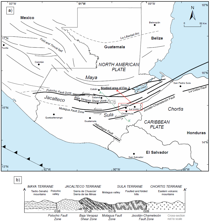
The geology of Guatemala is key to recognize geodynamic processes associated to plate tectonics, because it occupies a notable position along the plate boundary between North America and Caribbean plates, which are in tectonic contact along the transcurrent Polochic-Motagua Fault System (PMFS) (Donnelly et al., 1990, and references therein) (Figure 1a). While the classic studies somehow simplify the tectonic assemblage mostly as the contact of two blocks (Maya Block to the north and Chortís block to the south of the Motagua Fault, respectively, e.g., McBirney, 1963; Burkart et al., 1973; Dengo, 1985), more focused studies reveal the existence of several fault bounded crustal blocks, possibly allochthonous between them, characterized by distinct geological features, which can be considered as suspect terranes (e.g., Ortega-Gutiérrez et al., 2007; Ratschbacher et al., 2009; Torres de León et al., 2012; Solari et al., 2013) (Figure 1b). As those authors stress, each of the aforementioned crustal blocks is characterized by its different nature, which makes it different from the adjacent one in terms of age, metamorphic evolution, igneous and sedimentary content. All these peculiarities, which will be briefly synthesized in the forthcoming paragraphs, are in turn affected by the sinistral movement, ductile and brittle shearing associated with the evolution of the PMFS during Cenozoic (Ratschbacher et al., 2009; Pindell and Kennan, 2009). The focus on some of those elements contained in such deformed blocks can shed light on possible correlations that predate the Cenozoic shearing. That’s especially true for plutonic rocks, which are present in several localities and that span a large amount of geologic time, from Paleozoic (e.g., Solari et al., 2013), to Mesozoic (e.g., Clemons and Long, 1971; Ratschbacher et al., 2009; Torres de León et al., 2012), to Cenozoic (e.g., Ratschbacher et al., 2009). In this view, we are presenting some new data belonging to the La Unión pluton (LUP) one of the plutons cropping out in the Sula Terrane, intended to characterize its geologic features, age and geochemistry, as well as to allow comparisons with other similar igneous bodies.
GEOLOGIC SETTING
Moving from North America (north) to the Caribbean plate (south) along an hypothetic section, across Guatemala, one will cross all the suspect terranes (as in the definition of Ortega-Gutiérrez et al., 2007) or, most precisely, due to the lack of precise age information in several of those, fault blocks (Figure 1b). From north to south, thus, the fault blocks that represent the geological subdivision of Guatemala, are the Maya block, the Achi block, the Jacalteco block, the Motagua block, the Sula block, the Yoro block and the Chortís block. The Maya block is made up of local Precambrian rocks (Guichicovi Complex in southern Mexico, Weber and Kohler, 1999, and several outcrops in the El Triunfo Complex, Weber et al., 2018, 2020) that, together with Neoproterozoic low to medium-grade metasediments are intruded by abundant Ordovician to Mississippian and Permian igneous rocks (Weber et al., 2007; Estrada-Carmona et al., 2012; Ramírez-Fernández et al., 2021). The Achí terrane was originally interpreted by Ortega-Gutiérrez et al. (2007) as a separate crustal block, characterized by the Rabinal Granite suite intruding Neoproterozoic sediments (e.g., Ortega-Obregón et al., 2008; Solari et al., 2013). The studies in the El Triunfo Complex allow to interpret the Achi Terrane as the eastward continuation of the same sequence, thus pertaining to the Maya Block. Farther south, in tectonic contact along the Baja Verapaz Shear Zone (Ortega-Obregón et al., 2008), the Jacalteco terrane is mostly made up by the Chuacús Complex, containing Precambrian to Triassic metamorphic protoliths, and affected by ca. 218 Ma decompression melting and migmatization and Late Cretaceous high-pressure metamorphism (Ortega-Gutiérrez et al., 2004; Ratschbacher et al., 2009; Solari et al., 2011; Martens et al., 2012; Maldonado et al., 2018). South of the Motagua fault the Sula terrane is a completely different entity, made up almost entirely by the Las Ovejas Complex (Torres de León et al., 2012), characterized by medium to high-grade metasediments (Paleozoic to Jurassic protolith ages) metamorphosed under high temperature-low pressure during the Oligocene, and associated with Jurassic to Cretaceous plutons, with or without deformation (e.g., Ratschbacher et al., 2009). The Las Ovejas Complex was earlier seen as representative of the basement of the Chortís Block, since the studies of Bosc (1971) and Schwartz (1976) and the description of similar rocks in the Sierra de Omoa in Honduras (Horne et al., 1976). In fault contact with the Las Ovejas metasediments, the San Diego phyllite follows farther south. This unit, initially reported by Lawrence (1975) was studied by Torres de León et al. (2012) who demonstrated that its U-Pb detrital zircon content cannot be considered as the source of the Las Ovejas protoliths. Since the San Diego phyllite is older than Las Ovejas Complex, to which is in fault contact, has a lower metamorphic grade and possible correlative in the Cacaguapa schists on Honduras and northwerstern Nicaragua (Martens et al., 2007, and references therein) our interpretation is that it is the best candidate to be considered as the true basement of the Chortís block of Central America. Being positive that more studies are needed to clarify the significance of Proterozoic rocks in Honduras (e.g., Manton, 1996) and thus the true existence of Yoro terrane as proposed by Ortega-Gutiérrez et al. (2007). Although it is not part of the current study, it is worth to mention that both Jacalteco and Sula terranes are variably overthrust by mafic to ultramafic units, belonging to the Motagua terrane of Ortega-Gutiérrez et al. (2007) that groups all the different ophiolitic nappes cropping out in central Guatemala (Beccaluva et al., 1995; Brueckner et al., 2009; Flores et al., 2013).
LUP is one of the igneous bodies cropping out in the Sula Terrane, thus south of the Motagua, and north of the Jocotán-Chamelecón, faults (Figure 2). The lack of detailed studies induced some previous authors (e.g., Ratschbacher et al., 2009) to correlate LUP with the adjacent Chiquimula Pluton. The latter is a Late Cretaceous granite to granodiorite batholith, for which Ar/Ar in biotite yielded 90±10 Ma (Ratschbacher et al., 2009) and U-Pb LA-ICPMS zircon dating yielded 91±1 Ma (Torres de León, 2016).
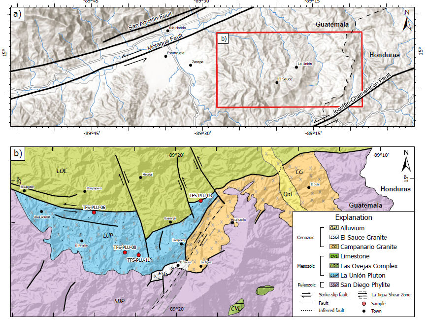
Figure 2 Location of the study area. a) Map of eastern Guatemala with the principal tectonic structures. The inset represents the location of the generalized geologic map b) with location of the La Unión Pluton and analyzed samples.
The field geology and mapping reveal that LUP has sheared and intrusive contacts along its northern and southern limits, respectively (Figure 2b); however, in some areas of the pluton, the original texture of the rock is still preserved (Figure 3a and 3b). Its northern limit with the adjacent orthogneisses is in fact a ductile shear zone, in which the original granite (probably a portion of the same LUP) is foliated, sheared, and metamorphosed after its emplacement (Figure 3c and 3d). Locally, in Lampocoy town (La Unión, Zacapa) it is possible to observe how the original igneous texture shows top-to-the-W shearing, indicated by deformed quartz ribbons (Figure 3d). The contact with the northern Las Ovejas metasediments and metaigneous rocks is also affected by deformation: although its kinematics is unclear because overprinted by the late, sinistral shearing along the Motagua Fault system, the presence of faults in the host rock just near the contact (Figure 3e) suggests a compressional regime, so probably a thrust of the host rock over LUP.
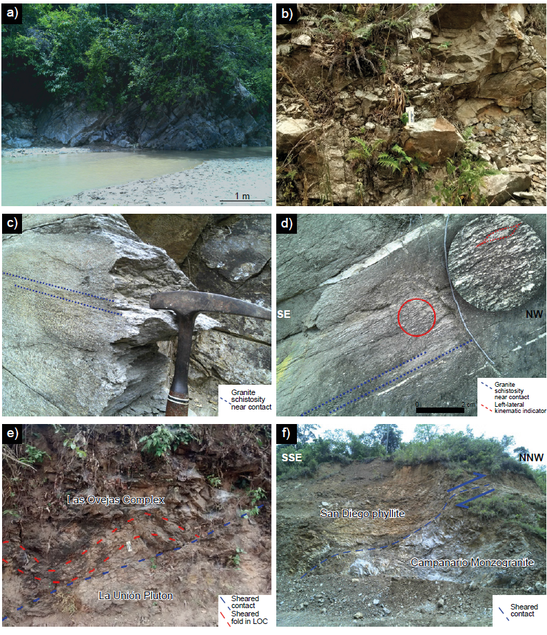
Figure 3 Field pictures. a) and b): Outcrop photographs of the La Unión Pluton near El Pinalito and Joya Grande towns, respectively. c) Schistosity as observed in La Unión Pluton near its tectonic contact with the Las Ovejas Complex rocks south of El Zapotón. d) Left-lateral, top-to-the-NW ductile kinematic indicators in the La Unión Pluton near Lampocoy. e) Shear contact between Las Ovejas Complex metasediments and La Unión Pluton. f) Another sheared contact, in this case of San Diego phyllite near Guaranjá, overthrusting the ca. 34 Ma Campanario monzogranite (Salguero-Díaz, 2016) near La Jigua. The presence of granitic dikes (one is visible in the left portion of the picture, just above the sheared contact) probably indicates that the original contact was intrusive and, then, affected by deformation.
The Río La Jigua Shear Zone, a subsidiary branch of the MotaguaJocotán-Chamelecón fault system, is also intensely shearing most of LUP intrusion, producing greenschist facies mylonite, also with topto-the-W shearing (mapped in Figure 2b). LUP southern limit with the San Diego phyllite is also affected by brittle and ductile faulting. This contact is better observable farther to W, where the ca. 34 Ma Campanario monzongranite (Salguero-Díaz, 2016) is overthrusted by the San Diego phyllite along a brittle fault (Figure 3f). The presence of small granitic dikes into the phyllite, however, suggests that the original contact is in fact intrusive, and later affected by faulting (see detail in the left portion of Figure 3f).
METHODS
Geochemistry
Four representative samples (sample coordinates in Table 1) of LUP were analysed by X-ray fluorescence for major elements at LANGEM, Instituto de Geología, Universidad Nacional Autónoma de México (UNAM), following the methodology reported by Lozano-Santacruz and Bernal (2005). Precision and accuracy of the X-ray fluorescence technique are generally better than ± 5 % for major elements. The same, selected samples were employed for the determination of rare-earth as well as trace elements at the Laboratorio de Estudios Isotópicos (LEI), Centro de Geociencias, UNAM, by ICP-MS, according to the methodology reported by Mori et al. (2007). The ICP-MS method indicates a precision and accuracy of < 5-10 %.
Table 1 Sample coordinates of the samples studied for geochronology and geochemistry. Datum: WGS84.
| Sample | Latitud (N) | Longitud (W) | Analysis |
| TFS-PLU-03 | 14°58'58.8" | 89°18'46.8" | Geochemistry |
| TFS-PLU-06 | 14°58'29.9" | 89°24'00.0" | Geochronology and geochemistry |
| TFS-PLU-08 | 14°56'45.5" | 89°22'30.0" | Geochemistry |
| TFS-PLU-11 | 14°56'38.4" | 89°21'46.7" | Geochronology and geochemistry |
Geochronology
Two samples of granite were chosen for U-Pb dating. They were crushed and the zircon grains separated with conventional techniques, terminating by handpicking under binocular microscope. U-Pb analyses were conducted by laser ablation inductively-coupled plasma mass spectrometry (LA-ICPMS) at Laboratorio de Estudios Isotópicos, UNAM, using a Resonetics M050 (now, Applied Spectra) 193 nm excimer laser workstation, coupled to a Thermo ICap Qc quadrupole mass spectrometer, according to the methods reported by Solari et al. (2018). A 23 μm spot was employed during this study for all the zircon U-Pb analyses, alternating unknown zircon crystals with several standards. The standard zircon 91500 was employed as external reference zircon (ca. 1062 Ma, Wiedenbeck et al., 1995), whereas Plešovice standard zircon acted as secondary (control) standard (ca. 337 Ma, Sláma et al., 2008). Together with those isotopes employed for U-Pb ratios and age calculation (Pb’s, Th, U) other isotopes were monitored for trace element concentrations (Si, Ti, Y, Nb, REE, Hf). The NIST 610 glass was measured and employed as an external standard for trace element concentration calculations, using 29Si as an internal (stoichiometric) standard element. Initial Pb correction was not performed, because the 204Pb signal is swamped by the isobar 204Hg present in the ICP carrier gas. Data were carefully filtered, using the cutoff discordance criteria of +30 % / -5 %. Raw data were reduced offline using Iolite 4 software (Paton et al., 2011), including all the error calculations and propagation, and employing the VizualAge data reduction scheme of Petrus and Kamber (2012). The secondary Plešovice standard zircon yielded a mean 206Pb/238U age of 339.4 ± 1.7 Ma, in agreement with its accepted age. All the data were plotted employing the free software IsoplotR (Vermeesch, 2018).
RESULTS
Four samples from La Unión Pluton were analyzed. Under the microscope, samples have an inequigranular to phaneritic texture that becomes equigranular in some samples.
Quartz crystals are mainly subhedral to anhedral and range from 24 % to 35 % in all samples (Figure 4a and 4b). Plagioclase range from 25-33 %. The crystals are anhedral-euhedral and present twin deformation (Figure 4c and 4d). This mineral phase is often altered to sericite and replaced by epidote. The K-feldspar are partially altered to sericite (Figure 4c). The crystals are subhedral to anhedral and, Their content ranges from 21 % to 24 % in all samples. Biotite is an abundant phase with content ranging from 5 % to 16 % (Figure 4d). The crystals are commonly replaced by chlorite. Muscovite crystals range from 4-8 %. Epidote is present as an accessory mineral with less than 2 %. Other accessory minerals include zircon, apatite, and opaque.
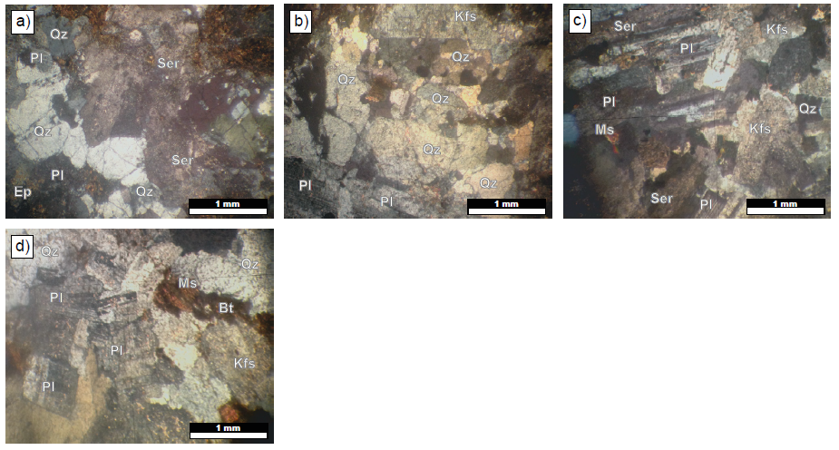
Figure 4 Polarized light photomicrographs of granite samples from La Unión Pluton. a) sample TFS-PLU-03; b) sample TFS-PLU-06; c) sample TFS-PLU-08; d) sample TFS-PLU-11. Mineral abbreviations: Qz - quartz; Pl - plagioclase; Kfs - K-feldspar; Ser - sericite; Bt - biotite; Ms - muscovite; Ep - epidote.
Based on the mineralogical modal content of quartz, alkali feldspar, and plagioclase, we classify the La Union Pluton as a monzogranite (Figure 5) according to the Le Maitre et al. (2002) classification.
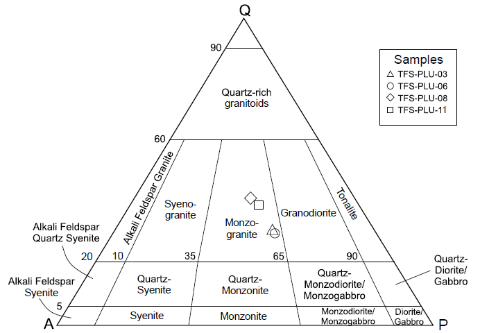
Figure 5 Modal classification for granite samples from La Unión Pluton. Q - quartz, A - K-feldspar, P - plagioclase.
Geochronology
The two rock samples selected for geochronology contain prismatic zircon crystals, with elongation up to 4:1 ratio, well-developed bipyramidal terminations and without any sign of corrosion and/or resorption. Under cathodoluminescence they show a clear igneous zoning, the presence of some tiny inclusions represented by apatite and quartz (Figure 6).
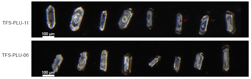
Figure 6 Cathodoluminescence images of some of the dated zircon grains. Note the bypiramidal morphology, as well as the igneous zoning developed around xenocrystic cores.
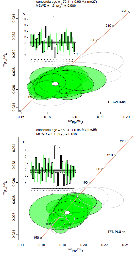
For each sample, 30 grains were analyzed. After discordance filtering, 27 (TFS-PLU-06) and 25 grains (TFS-PLU-11) were considered useful for age interpretation. The sample TFS-PLU-06 yielded a concordia age of 170.4±0.9 Ma (MSWD=1.3, Figure 7a and Table S1 of the supplementary material), whereas the sample TFSPLU-11 a concordia age of 169.4±0.95 Ma (MSWD=1.4, Figure 7b). Both ages are virtually the same, within the analytical errors. Thanks to the zircon shape and the igneous oscillatory zoning observed under cathodoluminescence, we can interpret the obtained ages as indicative of the LUP crystallization.
Geochemistry
Four samples from LUP were analyzed by major and trace element geochemistry. Samples have SiO2 values between 70-75 wt%., whereas Al2O3, Na2O and K2O ranging between 12-15 %, 3-5 %, and 4-6 % respectively (Table 2). The SiO2 vs. Na2O+K2O biplot (Middlemost, 1994) classify the samples in the Granite field due to their high SiO2 content (Figure 8a). Within the SiO2 vs. K2O diagram (Figure 8b), most samples are classified on the High-K Calc-alkaline series, and only sample TFS-PLU-06 plot near the boundary of the Shoshonitic series. On the A/CNK vs.A/NK plot (Shand, 1943), samples are classified as peraluminous granites (Figure 8c) with a strong I-type character according to the K2O vs.Na2O diagram of Chappell and White (1974) (Figure 8d).
Table 2 Major and trace-REE determined elements in studied samples.
| Sample | TFS-PLU-03 | TFS-PLU-06 | TFS-PLU-08 | TFS-PLU-11 |
| SiO2 (wt%) | 73.45 | 70.88 | 74.28 | 70.08 |
| TiO2 | 0.25 | 0.44 | 0.22 | 0.44 |
| Al2O3 | 12.58 | 14.11 | 13.56 | 13.62 |
| F2O3t | 2.77 | 2.97 | 1.99 | 3.57 |
| MnO | 0.09 | 0.19 | 0.05 | 0.11 |
| MgO | 1.03 | 1.12 | 0.85 | 0.89 |
| CaO | 1.12 | 1.43 | 1.56 | 2.01 |
| Na2O | 3.44 | 4.11 | 4.02 | 4.76 |
| K2O | 4.71 | 5.07 | 4.12 | 4.71 |
| P2O5 | 0.09 | 0.13 | 0.55 | 0.11 |
| LOI | 0.58 | 0.44 | 0.14 | 0.54 |
| Sum | 100.11 | 100.89 | 101.34 | 100.84 |
| Li (ppm) | 30 | 46 | 33 | 22 |
| Be | 3 | 2 | 2 | 2 |
| B | 6 | 10 | 5 | 9 |
| Sc | 7 | 8 | 8 | 9 |
| Rb | 126 | 105 | 89 | 132 |
| Cs | 5 | 6 | 4 | 5 |
| Ba | 577 | 545 | 1816 | 291 |
| Sr | 189 | 182 | 303 | 109 |
| Ga | 17 | 17 | 18 | 18 |
| Ta | 1.10 | 0.85 | 0.77 | 0.98 |
| Nb | 11 | 11 | 10 | 11 |
| Zr | 149 | 169 | 159 | 171 |
| Y | 27 | 22 | 13 | 24 |
| Cr | 25 | 22 | 24 | 23 |
| Ni | 11 | 9 | 10 | 10 |
| Co | 8 | 9 | 6 | 6 |
| V | 42 | 39 | 34 | 39 |
| Cu | 3 | 5 | 2 | 4 |
| Zn | 46 | 51 | 21 | 16 |
| Mo | 0.39 | 0.31 | 0.46 | 0.90 |
| Sn | 11 | 3.2 | 2.9 | 3.7 |
| Sb | 0.18 | 0.10 | 0.10 | 0.19 |
| La | 28 | 8 | 8 | 23 |
| Ce | 55 | 16 | 15 | 48 |
| Pr | 6.48 | 2.11 | 1.89 | 5.85 |
| Nd | 23.39 | 9.35 | 8.16 | 21.98 |
| Sm | 4.85 | 2.72 | 2.18 | 4.77 |
| Eu | 1.01 | 0.98 | 1.15 | 0.74 |
| Gd | 4.63 | 3.12 | 2.34 | 4.45 |
| Tb | 0.74 | 0.54 | 0.38 | 0.70 |
| Dy | 4.56 | 3.58 | 2.32 | 4.20 |
| Ho | 0.92 | 0.75 | 0.46 | 0.83 |
| Er | 2.62 | 2.13 | 1.25 | 2.33 |
| Yb | 2.59 | 2.20 | 1.43 | 2.32 |
| Lu | 0.39 | 0.33 | 0.22 | 0.35 |
| Hf | 3.94 | 4.38 | 4.08 | 4.44 |
| W | 1.68 | 0.49 | 0.35 | 0.59 |
| Pb | 15 | 15 | 10 | 10 |
| Th | 10 | 4 | 0.7 | 9 |
| U | 2.8 | 1.4 | 1.4 | 2.4 |
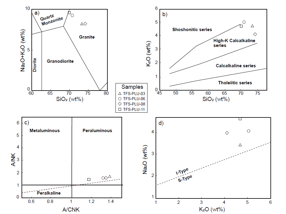
Figure 8 Geochemical classification of the studied granites. a) SiO2 vs. Na2O+K2O discrimination diagram (Middlemost, 1994); b) Peccerillo and Taylor (1976) discrimination diagram. c) A/CNK vs. A/NK diagram of Shand (1943) for metaluminous vs. peraluminous discrimination. d) K2O vs. Na2O diagram for discrimination between I-type and S-type granites. After Chappell and White (1974).
The chondrite-normalized REE patterns (Figure 9a) show moderately enriched Light Rare Earth Elements (LREE), when compared with Heavy Rare Earth Elements (HREE), with (La/Yb)n ranging between ca. 5 and 10 with variably Eu anomalies, positive for sample TFS-PLU-08, the size of which correlate with Al2O3 contents, suggesting accumulation of plagioclase in this rock, and negative to absent in the remainder samples, suggesting feldspar crystallization. The concave downward shape of heavy REE for the sample TFS-PLU-08 is characteristic of the garnet role in its evolution. The mantle normalized trace element patterns of all the rocks (Figure 9b) show depletion in Nb and Ti in three out of four samples, typical of subduction-related or crustallyderived magmas, while the remainder has positive anomalies of Eu, Sr, Ba, Ti, consistent with the accumulation of plagioclase and some Ti-rich phase (possibly, Ti-rich biotite). A volcanic arc tectonic setting is also indicated by the Rb vs. Y+Nb plot (Figure 10a). According to chemical classification of Batchelor and Bowden (1985) the rocks range from syn-collisional to late-orogenic (Figure 10b).
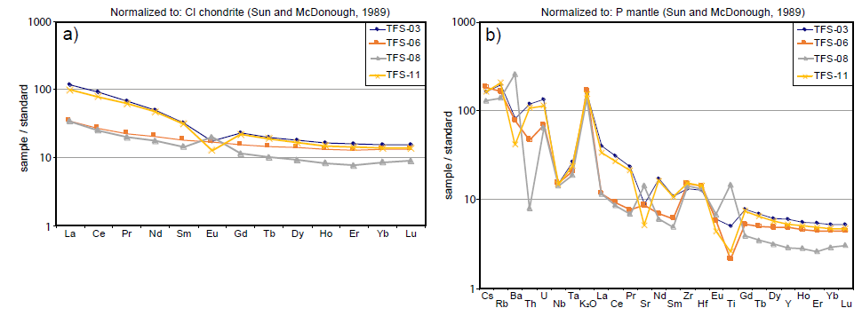
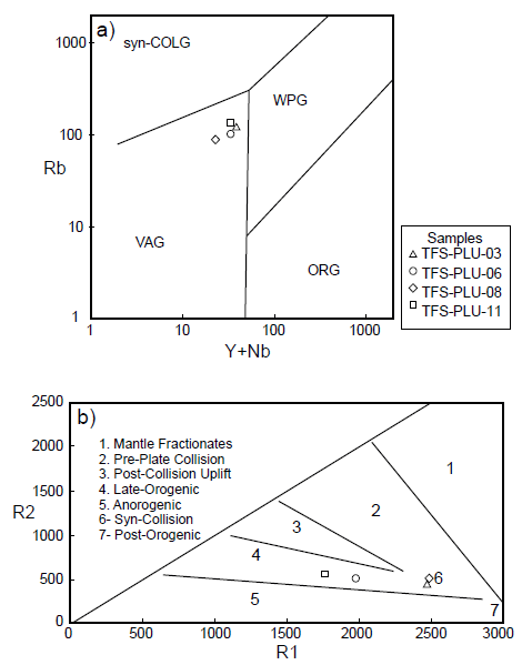
Figure 10 Tectonic discrimination diagrams for the studied samples. a) Rb vs. Y+Nb diagram, after Pearce et al., 1984. b) R1-R2 discrimination diagram of Batchelor and Bowden (1985). R1 equals 4Si-11(Na+K)-2(Fe+Ti), whereas R2 is equal to 6Ca+2Mg+Al. All cations are expressed as millications per 100 g.
DISCUSSION
Provenance of the LUP granitic magmas: subduction or rift processes?
This study provides some constraints on the Mesozoic magmatism in present Central America. While sheared and metamorphosed orthogneisses of Middle Jurassic age were previously reported, north of the studied area, by Torres de León et al. (2012), LUP is the first characterization of a mostly undeformed and unmetamorphosed Jurassic monzogranite in this portion of central Guatemala. Middle Jurassic ages from an orthogneiss with granitic protolith was previously reported by Ratschbacher et al. (2009) in central east of Guatemala. Rastchbacher et al. (2009) also reported Middle Jurassic ages of granites in central-western Guatemala (Sacapulas granite) and directly south of the Jocotán-Chamelecón fault near Chamelecón town in Honduras.
LUP chemical characterization suggests that the parental magmas originating LUP are high-K, mostly calc-alkaline, magmas which are either typical of subduction processes or related to partial melting of continental rock with arc-like signature.
While in northwestern Mexico the Jurassic continental magmatism is seen as the southern continuation of the Cordilleran system (see Martini and Ortega-Gutierrez, 2018, for a complete synthesis), in northeastern, central and southern Mexico Jurassic magmatism belonging to the Nazas Igneous Province (NIP) has been recently reinterpreted as crustally derived by partial melting of continental rocks during the extensional tectonics that accompanied the opening of the Gulf of Mexico, based upon a strict reinterpretation of its geochemical character (Parolari et al., 2022). The model proposed by Parolari et al. (2022) also applies to isolated Jurassic rocks of southwestern Mexico, such as: (a) a Middle Jurassic pluton with an age of 165 Ma reported by Guerrero-García et al. (1978) from the Acapulco - Tierra Colorada transect of the Xolapa Complex; (b) a ~158 Ma orthogneiss reported by Ducea et al. (2004) from north of Puerto Escondido; and (c) the Early Jurassic Tizapa metagranite (186.5 ± 7.4 Ma, lower intercept of discordant data) in the eastern Guerrero Terrane, Teloloapan subterrane (Elías-Herrera et al. 2000); (d) Jurassic, two-mica granites exposed E of the Puerto Vallarta batholith (Valencia et al., 2013; Schaaf et al., 2020). In southern Mexico a migmatization event is known in the eastern Acatlán complex (Magdalena migmatite, 175±3 and 171±1 Ma) and associated with a thermal unroofing during the breakup of Pangea (Keppie et al., 2004), thus it can be clearly ascribed to the same extensional event. In this view, a characterization of LUP magmas is needed, under the same geochemical parameters that compare, for instance, a compatible element, such as Sr, enriched in arc magmas, ratioed to Nb, a variably, but generally depleted element in subductionrelated magmas, which obtained Sr/Nb ratio can be compared to other two incompatible elements such as Rb and Nd, whose ratio is very low (<1) in intraplate basalts. Doing so and compare the studied ratios for LUP samples with a database of modern (Trans Mexican Volcanic Belt) and Mesozoic (Alisitos and NW) arcs in Mexico, as well as to the NIP Jurassic samples reported by Parolari et al. (2022), it is possible to observe that LUP samples fit with the NIP ones, being equally depleted in Sr, high in Rb and with low, but variable, Nb contents (Figure 11).
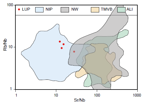
Figure 11 Rb/Nb vs. Sr/Nb ratios of LUP samples, compared with the same ratios in continental arc, subduction-related rocks (TMVB: Trans-Mexican Volcanic Belt; Ali: Alisitos; NW: northwestern Mexico) and continental magmas interpreted as sedimentary partial melts (NIP: Nazas Igneous Province). Comparison data taken from Parolari et al. (2022) and references therein.
Tectonic implications
South of the Sula terrane, in Central America, there aren’t any reports of Jurassic magmatic rocks. In Northern South America, Colombia is characterized by a vast Mesozoic magmatic arc (e.g., Bayona et al., 2020). Few localities, however, show Middle Jurassic magmatism, being mostly of Early Jurassic or even Late Triassic time (López-Isaza and Zuluaga, 2020). Practically, the Middle Jurassic igneous rocks are limited to the northern sector of Colombia, in the Alta Guajira and Serranía de Perijá (La Quinta Formation, Serranía de Perijá, 167±3 Ma, Dasch, 1982, Maze, 1984; Siapaná Granodiorite 167±9.4 Ma, Cardona et al., 2006; San Lucas Massif batholiths, 193-162 Ma, Cuadros et al., 2014; Segovia diorite, Upper Jurassic, Leal-Mejía, 2011; González et al., 2015a and 2015b; Segovia vulcanites of 165.5±2.1 Ma, González et al., 2015b; La Malena volcanics, 163.5±0.95 to 183.2±3 Ma, González et al., 2015c). Such rocks in northern Colombia are interpreted as belonging to subduction-related processes (e.g., López-Isaza and Zuluaga, 2020).
While the obtained ages sit the LUP magmatism in the Middle Jurassic, two regimes contributed to the generation of this magmatism for this time span: 1) the magmatism related to the subduction of the Farallon and Cocos plates, which were active at least since the beginning of Mesozoic, as the widespread magmatism since the Early Jurassic testifies (e.g., Spikings et al., 2015; Martini and Ortega-Gutiérrez, 2018, and Figure 12); together with 2) the extensional processes that produced several rift basins associated to the onset of the Gulf of Mexico opening (e.g., Engebretson et al., 1985; Pindell and Kennan, 2009; Martini and Ortega-Gutiérrez, 2018; Parolari et al., 2022, and references therein), the breakup of Pangea (e.g., Martini et al., 2022) with the relative migration of Gondwana toward SE and the formation of several NS and WNW-oriented lateral faults in southern Mexico (#1 to 5 in Figure 12, see also Zepeda-Martínez et al., 2021). The NS-trending lateral faults are subparallel to the Tamaulipas-Chiapas Transform zone, which corresponds to the main trace of the Yucatán displacement during the opening of the Gulf of Mexico (Figure 12). Several of those faults imply a complex history of WNW-ESE displacements during the thinning of the lithosphere caused by the Pangea breakup. Such processes, and the existence of that fault system, was previously envisaged by several authors (e.g., Anderson and Schmidt, 1983; Pindell and Kennan, 2009) and recently documented in southern Mexico by Zepeda-Martínez et al. (2021), who concluded that southern Mexico migrated from a more westward position during the Jurassic, toward ESE thanks to the action of such fault system (Figure 12). In this model it is envisaged that at least some of the magmatic arc previously emplaced into the continental crust, including LUP, suffered the same displacement toward ESE. Some remnant portion of this arc is represented by those plutons found in NW South America (La Guajira, Perijá, Mérida in Figure 12) was displaced toward SE during the Late Jurassic to Early Cretaceous by a continuous separation mechanism in which Gondwana reached its actual position.
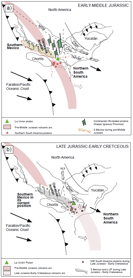
Figure 12 Proposed tectonic cartoon ranging from the a) Early-Middle Jurassic to b) Late Jurassic - Early Cretaceous. MSM: Mojave-Sonora megashear; TMVBF: Trans-Mexican Volcanic Belt Fault (Gastil and Jensky, 1973); TCT: Tamaulipas-Chiapas Transform Fault; Chm: Chiapas Massif; Chu: Chuacús Metamorphic Complex; G: La Guajira batholith; P: Perijá batholith; M: Mérida (from Bayona et al., 2020); 1-5: Salado River, Texcalapa, El Sabino, Caltepec and Oaxaca NNW-trending faults in southern Mexico (Zepeda-Martínez et al., 2021). Modified from Keppie et al. (2004); Pindell and Kennan (2009); Bayona et al. (2020); Martini and Ortega-Gutiérrez (2018); Zepeda-Martínez et al. (2021). LUP: La Unión Pluton (this paper). Bordered in red: envisaged position of some of the elements discussed in the text (southern Mexico), as well as some of the Middle Jurassic discussed plutons; in black, their position relative to the Middle Jurassic volcanic arc, after the displacement related to the action of the WNW-ESE major faults.
CONCLUSIONS
La Unión Pluton is a Bajocian (170 Ma), high-K calc-alkaline and peraluminous pluton intruding the Sula Terrane of Central Guatemala. It is interpreted as the (currently known) southernmost magmatic witness of the melting of continental sediments, during the process of crustal thinning that accompanied the initial stages of Pangea breakup. Such process is represented, in Mexico, by the Nazas Igneous Province (e.g., Parolari et al., 2022) whose emplacement accompanied the breakup of Pangea and opening of the Gulf of Mexico.

