


 text in
  English (pdf)
 Article in xml format
 Article references
 Send this article by e-mail
 Cited by SciELO
  Similars in
SciELO
Similars in
SciELO 
 Permalink
1. Introduction
Road transportation is a fundamental service for the economic development in Brazil, directly influencing aspects of production and consumption, since the country has its infrastructure oriented to the road mode (Andrade; Maia; Lima Neto, 2015). Nevertheless, this model accounts for 61% of cargo transportation in Brazil and is the main system for passengers’ traffic. As for social and economic aspects, this sector is responsible for generating more than 1.5 million direct jobs and contributes for 12.7% of the Gross Domestic Product of non-financial services nationally (CNT, 2017).
Despite its importance, historically little attention has been given to maintaining the infrastructure of Brazilian highways, which reflects in the depreciation of the road network, a situation that has intensified with the economic crisis that the country has been going through since 2013 (CNT, 2017). As a result of the lack of investments, it is estimated that more than 50% of the highways have some type of pathology, and of these, 19% are in a general state of poor or very bad conservation. According to the World Economic Forum (FEM), Brazil ranks 111th out of 138 countries in terms of road infrastructure quality (CNT, 2017; FEM, 2016).
Among the main reasons for the deteriorated state of the Brazilian road network, the National Department of Transport Infrastructure (DNIT, 2011) attributes the absence of a Pavement Management System (SGP), which would make possible to achieve the best possible application for public resources available and offer safe, compatible and economical road transport with the growing Brazilian demand. Without it, there is the adoption of inadequate projects for the roads, developed without detailed survey of the pavement or the situation in which the land is found (Viera, et al 2016). The base for an efficient SGP is the adoption of suitable methods for pavement evaluation, through which it’s possible to verify the need for maintenance or reconstruction of the road, as well as to determine if it was built according to the project specifications (Haas; Hudson, 1978; Viera, et al 2016)
The superficial evaluation of pavements is usually executed following the DNIT 006/2003 - PRO standard, which uses the Global Gravity Index (GGI) method. This method makes possible to objectively analyze the level of deterioration of a pavement according to the incidence of surface defects, indicating its conservation conditions and assisting in making decisions regarding the necessary interventions. Although the GGI is considered an efficient method and is widespread in the technical environment, it presents as a disadvantage the need for surveys by walking, which makes its application time-consuming and costly for application in large areas.
An alternative to avoid this problem is the use of the so-called unmanned aerial vehicles (UAVs), which can fly automatically or be piloted by electronic and computational means. This equipment was designed for military purposes, initially used in missions that are too dangerous to be performed by human beings (Resende, 2015). However, in recent years, it has been gaining prominence among civil interventions, configuring an emerging technology in civil engineering with applications ranging from the inspection of works, to the inspection of structures in high-risk environments (Melo, 2016).
With regard to the application of UAVs in transport infrastructure, its embedded sensors constitute a new and economical source of information and can even assist efforts to road’s maintainance (Branco, 2016; Nishar et al., 2016). Despite this, there have been few studies with this technology, especially as a tool for assessing road damage.
Thus, considering the need to optimize the road evaluation process in support of SGP and the potential offered by UAVs, it is essential to develop methodologies that enable its use in an efficient and technically appropriate way (Breen et al., 2015; Nishar et al., 2016). To this end, this work aims to study the feasibility of using Drones for mapping and inspecting pathologies on asphalt pavements, comparing and confronting their results to the traditional method of analysis.
2. Material and methods
2.1 Research Area
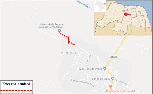
It was used as a sample unit of the present research, a stretch of single way asphalt track with approximately 0.5 km in length that gives access to the campus of the Federal Rural University of the Semi-Arid / UFERSA, in the municipality of Angicos, state of Rio Grande do Norte - Brazil (Figure 1). This stretch, although small in length, proved to be ideal for carrying out the study due to the large number of pathological manifestations on the pavement.
2.2 Survey of pathologies by the traditional method (reference)
To survey existing pathologies in the study area, sample plots were established every 20 m (in alternating flow-hands), each 6 m long, as established by DNIT Standard 006/2003 - PRO (Figure 2). Altogether 20 stations were considered, which had their defects noted, taking into account the section of the terrain and the types of pathological manifestation, distinguishing between cracks, plastic or consolidated corrugation, shoving, potholes, exudation, wear, patches and wheel tracks streaking. Photographic records of all types of defects found in the section under study were also made.

2.3 Survey of pathologies with Drone (alternative)
To acquire the images of the research area, an Unmanned Aerial Vehicle - UAV, from the manufacturer DJI model Phantom 4 PRO (Figure 3) was used. The referred UAV is a multirotor type weighing approximately 1.5 kg and is equipped with a 20 megapixel camera (capable of shooting at 4 k / 60 fps), with a video transmission range of 7 km. The choice of equipment was based on its ease of use, flight stability, quality of the images generated and affordable price.

For the flight planning stages and subsequent composition of the orthoimage, the Drone Deploy application was used. It allows the flight plan to be parameterized according to the desired resolution for the original images, image overlay rate, flight lines and resulting resolution. The flight parameters used in the present study can be seen in Table 1. The orthoimage was automatically generated by the application and exported for later analysis (Figure 4).
Table 1 Flight parameters used in the survey
| PARAMETER | VALUE |
|---|---|
| Altitude | 70 m |
| Resolution | 2,4 cm/pixel |
| Horizontal overlay rate | 65% |
| Vertical overlay rate | 75% |
| Flight speed | 15 m/s |
| Flight duration | 6 minutes |
| Number of captures | 109 |

2.4 Global Gravity Index (GGI) calculation
After the pathologies were mapped, the Global Gravity Index (GGI) for the research area was calculated, following the recommendations of the normatization DNIT 006/2003 - PRO. Initially, the absolute frequency (fa) of occurrence of each type of pathological manifestation was estimated, corresponding to the number of times the occurrence was verified. Then, the relative frequency (fr) for each pathology was obtained, through Equation 1. For each type of pathology, the Individual Gravity Index - IGI (Equation 2) was calculated, which were later added together, resulting in the IGG (Equation 3).
Wich,
fa - absolute frequency
n - number of inspections (númber of samples).
Wich,
fr - relative frequency
fp - ponderation factor (according to DNIT’s table)
The results obtained by the reference and alternative methodologies were compared according to the number and type of pathologies identified, as well as the time spent to carry out the surveys. Finally, the obtained GGI’s were compared with the DNIT 006/2003 - PRO Standard, in order to determinate the concept of degradation of the analyzed section (Table 2).
3. Results and discussion
3.1 Comparative analysis: Drone inspection vs. Traditional inspection
The analyzed section presented a large number of pathologies in both methods employed. The total quantification of pathologies, within the 20 plots evaluated, showed very close values for both methods, being 54 for traditional inspection and 53 for inspection with the Drone, which demonstrates the viability of using the Drone to quantify pathologies on pavements (Figure 5).

As for the qualitative aspect, the inspection carried out with the Drone enabled the identification of 04 types of pathologies, which are: potholes (P) - concavity or hole that forms in the coating and can reach the base; cracks (F) - characterized as openings in the asphalt surface that are visible to the naked eye; patches (R) - defect characterized by the filling of pots or any other orifice, hole or depression with asphalt mix; and slip (E) - displacement in relation to the pavement layer. Regarding the types of pathologies, there was no difference between the traditional inspection method and the Drone inspection method. Regarding the number of defects by type of pathologies, there were small differences between the methods used, as shown in figure 6.

It should be noted that the most probable cause for these differences is due to the fact that some types of pathologies can be difficult to identify by the use of images obtained by UAVs due to their quality, while traditional inspection can resolve any doubts regarding the occurrence of a pathology because it is an on-site analysis. As an example, one can compare pots and cracks. In the first case, it is easier to identify by the very nature of the pathology, which in general stands out from the rest of the pavement. In the second, it is much more difficult to identify, sometimes needing confirmation through on-site inspection. In Figure 7, it is possible to compare the images obtained with the Drone and using the traditional method, for each of the types of pathologies identified.

Regarding the time spent for inspection, it was found that the analysis performed with the Drone (6 minutes of flight and 12 minutes for image evaluation) took less than 1/3 of the time spent to perform the traditional inspection (Figure 8 ). Considering that in the present study a small stretch of 0.5 km was evaluated, it is assumed that on longer stretches of large highways this difference is even greater, making the use of the Drone increasingly attractive

3.2 Comparative Analysis of the results: Drone x Traditional inspection
The value obtained for the Global Gravity Index - GGI, was 302 for the realization performed with the Drone and 320 for the traditional method (Figure 9), and in both cases, according to DNIT Standard 006/2003 - PRO , the evaluated stretch was considered to be terrible (GGI> 160). One of the points that influences this result is the presence of a large number of Potholes (P), which was found in all the studied plots, which is the pathology that most impacts traffic and contributes to accelerating the degradation of the pavement. Although there are different values, it is observed that the existing difference is not as long as, demonstrating that navigation with the aid of Drones is technically feasible.

3.3 General Analysis of the proposed Methodology
The methodology of UAV using for pavement inspection can already be observed in works such as Parente, Felix and Picanço (2017), where, as in the present work, this tool was used in comparison with the current standard methodology. The addition of a comparative evaluation between the proposed method and the traditional one is essential for the statistical quantification of the effectiveness of any proposed alternative methodology. Therefore, another result pointed out by this work is a comparison methodology for the use of UAVs in inspections of structures of any type, when compared to traditional methods.
4. Conclusion
The use of Drones has become increasingly common in several areas of engineering, stimulated mainly by the popularization of this technology and the various possibilities offered. However, its use must be previously evaluated and traditional methodologies must be adequate so that the results provided by this equipment are reliable. The present study demonstrated the use of Drones to inspect pathologies on asphalt pavements, based on DNIT 006/2003 - PRO, obtaining approximately 94.4% of correctness, taking into account the results with the traditional methodology, with significant reduction in operating time with less than 1/3 of the time spent. It should also be noted that the present work provides subsidies for the improvement of the road evaluation process, making it possible to achieve the best possible application for the public resources and offering safe, compatible and economical road service. The proposed method can also be refined by the use of Drones with multispectral sensors, generating other results that, through infrared or three-dimensional images, can add value and different information to the service related to pavement inspections, also increasing the effectiveness of the alternative methodology.

