SciELO - Scientific Electronic Library Online

 
vol.26 issue2Height-diameter-age equation systems for Pinus arizonica Engelmann and Pinus durangensis Martinez in mixed-species stands in Durango, MexicoChoice experiments for the management of Los Mármoles National Park, Mexico author indexsubject indexsearch form
Home Pagealphabetic serial listing  

Services on Demand

Journal

Article

Indicators

Related links

  • Have no similar articlesSimilars in SciELO

Share


Revista Chapingo serie ciencias forestales y del ambiente

On-line version ISSN 2007-4018Print version ISSN 2007-3828

Rev. Chapingo ser. cienc. for. ambient vol.26 n.2 Chapingo May./Aug. 2020  Epub Apr 23, 2021

https://doi.org/10.5154/r.rchscfa.2019.07.054 

Scientific article

Modeling of landslide sensitive areas using GIS in semi-arid forests and evaluation in terms of forest rehabilitation

Ender Buğday1  * 

Halil Barış Özel2 

1Çankiri Karatekin University, Faculty of Forestry. Yeni mahalle Bademlik caddesi, 18200-Çankiri, Turkey.

2Bartın University, Faculty of Forestry. 74110-Bartin, Turkey.


Abstract

Introduction:

In order to increase, protect, and sustain forest assets, it is important to determine the factors that affect forestry activities and minimize their impact. In this study, the landslide factor in forestry applications was tackled. The negative effect of unpredictable factors of forestry activities (road construction, harvesting, afforestation, etc.) can be reduced by calculating and modeling the landslide susceptibility ratios of degraded forests.

Objective:

To demonstrate the applicability of a landslide susceptibility map for supporting decision makers in the assessment of semi-arid and landslide-sensitive forestlands in forestry activities and rehabilitation works.

Materials and method:

Six models were introduced by using the fuzzy inference system (FIS) and modified analytical hierarchy process (M-AHP) approaches. A combination of elevation, slope (degree), distance to faults, lithology, aspect, and plan curvature was used in the models.

Results and discussion:

The most successful models under the FIS and M-AHP approaches were FIS Model 3, and M-AHP Model 1, with areas under the curve (AUC) of 80.2 %, and 78.1 %, respectively. Using precision forestry by making decisions based on the area’s landslide susceptibility in the management and planning stage (e.g., construction of forest infrastructure facilities, afforestation, and forest harvesting and rehabilitation), will increase the success of forestry activities.

Conclusion:

It is very important to determine the landslide areas in advance and reliably for effective execution of forestry practices in landslide sensitive forestlands, in order to increase the success of forestry activities in accordance with the sustainable forest management approach.

Keywords: Forestry; forest activities; susceptibility map; fuzzy inference system; modified-analytical hierarchy process

Resumen

Introducción:

Para aumentar, proteger y mantener los recursos forestales, es importante determinar los factores que afectan las actividades forestales y minimizar su impacto. En este estudio se abordó el factor de deslizamientos de tierra en aplicaciones forestales. El efecto negativo de factores impredecibles de las actividades silvícolas (construcción de carreteras, cosecha, forestación, etc.) puede reducirse calculando y modelando las relaciones de susceptibilidad a deslizamientos de tierra de bosques degradados.

Objetivo:

Demostrar la aplicabilidad de un mapa de susceptibilidad de deslizamientos de tierra para apoyar a los tomadores de decisiones en la evaluación de bosques semiáridos, en actividades forestales y trabajos de rehabilitación.

Materiales y métodos:

Se introdujeron seis modelos utilizando los enfoques del sistema de inferencia difusa (FIS) y del proceso de jerarquía analítica modificada (M-AHP). Se utilizó una combinación de elevación, pendiente (grado), distancia a las fallas, litología, aspecto y curvatura del plan en los modelos.

Resultados y discusión:

Los modelos más exitosos bajo los enfoques FIS y M-AHP fueron el Modelo 3 del FIS y el Modelo 1 del M-AHP, con áreas bajo la curva (AUC) de 80.2 % y 78.1 %, respectivamente. El uso de la silvicultura con precisión mediante la toma de decisiones basadas en la susceptibilidad a los deslizamientos de tierra, en la etapa de gestión y planificación (por ejemplo, construcción de instalaciones de infraestructura forestal, forestación y aprovechamiento y rehabilitación de bosques), aumentará el éxito de las actividades silvícolas.

Conclusión:

Es muy importante determinar las áreas de deslizamiento de tierra de manera anticipada y confiable para la ejecución efectiva de prácticas silvícolas en tierras forestales susceptibles, con el fin de aumentar el éxito de las actividades silvícolas de acuerdo con el enfoque de gestión forestal sostenible.

Palabras clave: Silvicultura; actividades forestales; mapa de susceptibilidad; sistema de inferencia difusa, proceso de jerarquía analítica modificada

Introduction

Various biotic and abiotic factors are involved in the degradation and destruction of the forest-one of the world’s most important natural resources. This situation is the result of global warming, which is the main environmental problem for Earth’s current population. Incidence of drought and desertification are the strongest indicators of this situation. As a result of the destruction of the forest ecosystem, semi-arid areas are formed, and drought and desertification arise due to the increasing severity of the consequences of human-induced climate change (Türkeş, 2012). From a macroperspective, forest assets and diversity of species are also affected due to a decrease in the amount of precipitation (Fang et al., 2005; Food and Agriculture Organization of the United Nations [FAO], 2018; Park & Sohn, 2010; Yang, Fang, Ma, & Wang, 2008).

It is very difficult to maintain the continuity of forest assets in semi-arid regions, thus, resulting in the decrease of forest assets in semi-arid areas over the last 40 years (Song et al., 2018). Factors increasing deforestation also trigger landslides and erosion, which reduce the amount of living cover protecting the upper layer of the soil. Increasing the vegetation cover as much as possible is crucial for both water retention and reducing the extreme points in the water balance sheet (Tang et al., 2018).

Turkey is located in the temperate zone and considered a macroclimate (Yilmaz & Cicek, 2018). It borders the sea on three sides, and there are more forest assets in regions along the coast than further inland, which are considered semi-arid areas with little rainfall, due to the effects of climate change (General Directorate of Forestry [GDF], 2015). Afforestation and rehabilitation activities have been carried out for many years in order to increase the quantity and productivity of forests, which is especially scarce in the inner parts of Turkey (GDF, 2017). Considering that approximately 43 % of Turkey's forests are degraded (GDF, 2015), the severity of the situation is increasing.

In areas where degraded forests are widespread, it is necessary to increase the success of forest maintenance, regeneration, and rehabilitation works, and to ensure benefit from forests with minimum damage (Keller, Asner, Silva, & Palace, 2004; Soriano, Kainer, Staudhammer, & Soriano, 2012; Sirén, Ala-Ilomäki, Mäkinen, Lamminen, & Mikkola, 2013; Wilson & Oliver, 2000). The importance of precision forestry applications, especially in semi-arid regions, is increasing. The forests can be stabilized and then rehabilitated, even after many years, through technical and ecological measures, such as ecological restoration, rehabilitation, and afforestation, especially in areas with extreme climate (semi-arid, arid, dune, and erosion areas). However, in order to reestablish productive forests in semi-arid and arid areas, it is necessary to first obtain detailed, sensitive, and high-quality data during the implementation of technical and ecological measures, and to then carefully plan the forest establishment activities based on these data (Raum, 2017). These forest planning activities support the main concerns of the management, and objective assessment of forest projects, from a scientific and economic point of view. For this reason, well-designed planning procedures can be implemented to allow the monitoring of everything from simple anthropogenic disturbances to more complex climate, geomorphological, and physical disturbances (Vallauri, Aronson, Dudley, & Vallejo, 2005).

Considering the sensitive ecological conditions of both semi-arid and arid climates, the success of the aforementioned applications in these areas can be increased by (a) rehabilitation of degraded forests, reforestation, and harvesting activities carried out in existing forest assets (Daoyin & Yaoxiang, 2007), (b) planning them with a multidirectional approach by taking the factors affecting these activities into account (Bizikova & Krcmar, 2015).

Many studies in the current literature that were conducted in landslide areas used different modeling approaches for multidirectional evaluations. The basis of these approaches is the assessment of multiple factors. Some of these approaches are as follows: Machine Learning (Sahin, Colkesen, & Kavzoglu, 2018), Adaptive Neuro Fuzzy Inference System (Sezer, Pradhan, & Gokceoglu, 2011), Artificial Neural Networks (Chen, Pourghasemi, & Zhao, 2017), Support Vector Machine (Chen, Pourghasemi, & Naghibi, 2018), Logistic Regression (Ayalew & Yamagishi, 2005), Fuzzy Inference System (Pourghasemi, Pradhan, & Gokceoglu, 2012), Modified-Analytic Hierarchy Process (Kornejady, Pourghasemi, & Afzali, 2019), Bivariate Statistical Analysis (Jiménez-Perálvarez, Irigaray, El Hamdouni, & Chacón, 2011), Statistical Index (Pourghasemi, Moradi, & Aghda, 2013), and Frequency Ratio (Akgun, Dag, & Bulut, 2008).

Various factors are used in order to present landslide susceptibility map (LSM), including elevation (Ayalew & Yamagishi, 2005; Lee & Sambath, 2006), distance to roads (Dahal et al., 2008), land use (Bai et al., 2010), slope (Gokceoglu & Aksoy, 1996), distance to faults (Pourghasemi et al., 2012), lithology (Yalcin, 2008), distance to streams (Pourghasemi et al., 2013), aspect (Yesilnacar & Topal, 2005), plan curvature (Nefeslioglu, Duman, & Durmaz, 2008), and the topographic wetness index (Devkota et al., 2013).

This study was carried out in a semi-arid region susceptible to landslides, which is one of the factors negatively affecting forest assets. The objective of the research was to model the landslide susceptibility in terms of topographic factors (elevation, slope, faults, lithology, aspect, and plan curvature) and to support decision-making in activities to be conducted in such areas. It will then be possible to carry out more successful forestry activities (construction of forest infrastructure facilities, harvesting, afforestation and rehabilitation) in forests susceptible to landslide during planning and application in the context of precision forestry. Also, with the addition of landslide susceptibility to decision-making processes as a factor, the success of forestry activities, which are long-term investments, could be increased.

Materials and Methods

Study Area

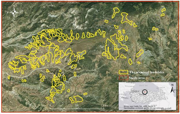
The study area is located within the area of responsibility of Sarikaya Forest Sub-District Directorate in Cankiri Forestry Management Directorate affiliated with Ankara Forestry Regional Directorate. This area is located between 40° 47' 56" - 40° 46' 51" northern latitude and 33° 58' 08" - 34° 01' 06" eastern longitude. It has a size of 171.37 km2 and landslides of various numbers and sizes have occurred in the past years (Figure 1). The study area is located in a high mountainous area. The average slope of this area is 15°, the dominant aspect is the south facing direction and the average height is 1 410 m, ranging from 1 083 m to 2 061 m.

Figure 1 Location of the study area (Sarıkaya-Turkey) and occurred landslides (before 2017). 

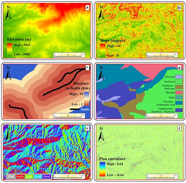
There are not any common procedures to establish the most influential factors in LSM studies (Sahin et al., 2018). Combinations of different factors are used in each LSM study. The most important feature affecting these combinations comes from whether the data are available or not. This situation, which is to affect the success of the direct models, leads researchers to carry out modeling using different factors and their combinations in different landslide areas. Pourghasemi et al. (2012) stated that the factors of height, slope (degree), aspect, and lithology were most used in LSM studies. In addition to this, data quality affects the success of the model significantly (Jacobs et al., 2018). In this study, 12.5 m × 12.5 m high-resolution digital elevation model (DEM) data were used. All the factors used in this study were obtained from this DEM. Six factors were evaluated for the modeling in the study: elevation, slope (degree), distance to faults, lithology, aspect, and plan curvature.

Factors

Elevation is one of the most commonly used factors in landslide susceptibility studies (Buğday, 2018; Meng et al., 2016). The average height in the study area is 1 410 m, minimum height is 1 100 m, and maximum height is 2 050 m. In this study, the elevation factor has been classified in five classes (1 000 m to 2 250 m; Figure 2a). Slope (degree) is one of the most frequently used factors in landslide susceptibility studies (Behling, Roessner, Kaufmann, & Kleinschmit, 2014; Eskandari, Homaee, & Falamaki, 2016; Niu et al., 2018). The average slope in the study area is 14.33°, whereas the minimum is 3.25°, and maximum is 54.83°. In this study, the slope was classified into five different groups: 0-4.99°, 5-11.99°, 12-17.99°, 18-21.99° and 22-65.8° (Figure 2b). Distance to faults is an important factor increasing the landslide formation and the size of landslides considerably (Feizizadeh, Blaschke, & Nazmfar, 2014; Meng et al., 2016). Distance to faults was classified into six different groups: 0-0.99 km, 1-1.99 km, 2-2.99 km, 3-3.99 km, 4-4.99 km, and 5-10 km (Figure 2c). Lithology is a factor commonly included in landslide susceptibility studies (Pourghasemi & Kerle, 2016). Lithology map was derived from the 1:100 000 scale geological map (Duman, Çan, & Emre, 2011) obtained from the General Directorate of Mineral Research and Exploration (MTA). There are six different lithological groups in the study area: clastic and carbonate rocks (k2: Cretaceous), terrestrial clastic rocks (pl: Pliocene), evaporative sedimentary rocks (olm1: Oligocene-Miocene), clastic rocks (e1-2: Eocene), basic and ultrabasic rocks (of: Mesozoic) and Quaternary (Q) formations (Figure 2d). The study area is one of the areas where landslides occur frequently within the provincial boundaries. It is highly prone to landslides due to the Cretaceous age and sandstone content (Sahin et al., 2018). The aspect factor is one of the factors included in this type of study (Niu et al., 2018; Yalcin, Reis, Aydinoglu, & Yomralioglu, 2011), and it was classified into five different groups (plain, north, east, south and west) in this study (Figure 2e). The dominant aspect of the study area is the south. Plan curvature factor is one of the factors frequently referred to in order to establish the direction of slope in landslide studies (Oliveira, Zêzere, Guillard-Gonçalves, Garcia, & Pereira, 2017; Pourghasemi & Kerle, 2016). Plan curvature was divided into five groups for this study: -0.098, -0.023, 0.013, 0.093, and 0.639 (Figure 2f).

Figure 2 Factors used in modelling landslide susceptibility. 

Landslide Susceptibility Mapping Process

The process and procedures carried out to establish LSM in this study are provided in Figure 3’s flowchart.

Figure 3 Flowchart of the landslide susceptibility map. 

In this study, the locations and sizes of landslides (Duman et al., 2011) were obtained from the MTA. A total of three different models were formed by using six factors in the study. The models were generated according to fuzzy inference system (FIS) and modified analytical hierarchy process (M-AHP) approaches. FIS is an approach that is widely used in simulation processes (Bellman & Zadeh, 1970; Chang & Zadeh, 1996). The values in the FIS approach are not limited to 0 to 1, but the studies with intermediate values are reflected in the database. In the models generated, according to the FIS approach, membership functions are assigned first. At this stage, depending on which factor is low or high, the degree to which landslide susceptibility will be impacted (very low-very high) is entered and learning rules are determined. In the following process, the model is generated as a result of the combination of factors on the scale of these rules. The M-AHP approach has various advantages in the modeling process in terms of eliminating the subjectivity of the classical AHP approach and not requiring user experience (Banuelas & Antony, 2004; Pourghasemi & Rossi, 2017). Here, after the values included within the factors are normalized, they are scored according to the rate of affecting the landslide susceptibility (1, 3, 5, 7, 9, etc.). Afterwards, these factors are combined and the models are obtained for LSM. The scores used for M-AHP in this study are displayed in Table 1. The combinations of the factors used in the models formed according to FIS and M-AHP approaches in this study are shown in Table 2.

Table 1 Factors’ Scores for modified analytical hierarchy process (M-AHP) in this study. 

Factors Classes Score Factors Classes Score
Elevation (m) 1 000 - 1 250 1 Slope (degree) 0 - 5 1
1 250 - 1 500 3 5 - 12 3
1 500 - 1 750 5 12 - 18 5
1 750 - 2 000 7 18 - 22 7
2 000 - 2 250 9 22 - 66 9
Aspect Flat 1 Plan Curvature -0.098 9
North 3 -0.023 7
East 3 0.013 5
South 7 0.093 3
West 5 0.639 1
Distance to Faults (km) 0-1 9 Lithology Alluvium 9
1-2 9 Sandstone 7
2-3 7 Sandstone - Mudstone 5
3-4 5 Melange 3
4-5 3 Shale 1
5-10 1 Volcanite - Sedimentary rock 5
Conglomerate - Sandstone - Mudstone 5

Table 2 Combinations of factors used in the models formed according to fuzzy inference system (FIS) and modified analytical hierarchy process (M-AHP) approaches. 

Factors Model 1 Model 2 Model 3
Elevation ( ( (
Slope (degree) ( ( (
Distance to faults ( ( (
Lithology ( ( (
Aspect ( ( -
Plan curvature - ( -

Model Validation

In this study, the widely used and reliable receiver operating characteristic (ROC) curve (Buğday, 2018; DeLong, DeLong, & Clarke-Pearson, 1988; Oh & Pradhan, 2011) was preferred for the validation of the models generated. The ROC curve is calculated by the ratio of sensitivity to accuracy, where the threshold value for binary classification systems differs (the threshold value was determined as 0.50). The success rate of the models was determined by the area under curve (AUC).

Results and Discussion

It was determined that, in this study area, a total of 107 landslides occurred (1965-2017), with an average size of 12.9 ha, a minimum of 1.11 ha, and a maximum of 144.76 ha, according to the landslide inventory obtained from the MTA. The total area of landslides within this area is 1 357.68 ha. The landslides that occurred in the area, according to the MTA classification, consist of 430.75 ha of former landslide areas, and 926.93 ha of active landslide areas. It is reasonable to assume that the study area is under constant landslide pressure.

A total of six models were generated in this study; three of them according to the FIS approach, and three according to the M-AHP approach (Figure 4). The values obtained after the validation of these models were as follows: Model 1 AUC = 79.9 %, Model 2 AUC = 78.3 %, and Model 3 AUC = 80.2 %, according to the FIS approach. According to M-AHP approach, the following values were determined: Model 1 AUC = 78.1 %, Model 2 AUC = 75.9 %, and Model 3 AUC = 72.9 % (Figure 5).

Figure 4 Models layouts according to fuzzy inference system (FIS) and modified analytical hierarchy process (M-AHP) approaches. 

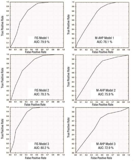
Figure 5 Models’ validations (receiver operating characteristic curve and area under curve [AUC] values) using fuzzy inference system (FIS) and modified analytical hierarchy process (M-AHP) approaches. 

Landslide susceptibility should be considered as a factor in all forestry activities carried out in Turkey in order to increase the forest assets in the semi-arid areas and ensure their sustainability. Within this context, this study was carried out in order to support planning in landslide sensitive areas and their surrounding forest areas using advanced GIS methods. The model that best conveys the LSM among the six models obtained from the study is FIS Model 3 (AUC = 80.2 %). Factors composing FIS Model 3 are elevation, distance to faults, and lithology. By using the FIS method, Vahidnia et al. (2010), Akgun et al. (2012), and Pourghasemi et al. (2012) generated LSM model with 90.5 %, 85.5 %, and 89.7 % success rates, respectively. Jiménez-Perálvarez (2011) and Buğday (2019) obtained results similar to those of this study, generating a model with an 83.2 % and 82.1 % success rate, respectively, using the FIS approach in the mountainous semi-arid area. In this study, more successful results were obtained with FIS models than M-AHP models. Similar to this study, Pourghasemi et al. (2012) compared the FIS approach and AHP approach and found that FIS generated more successful models. As with all modeling studies, success in conducting landslide susceptibility modeling depends on quality data (Buğday, 2018; Yalcin, 2008). Precision forestry principles can be used to access quality information. In such studies, obtaining sensitive data and the success of models generated from this data were considered to be higher.

Conclusions

The main purpose of modeling is to perform analyses with multiple parameters and data to reveal the most successful models with the least number of factors. In framework of sustainable forest management, and precision forestry principles, evaluating unpredictable factors using models increases the reliability of conducting forestry applications (road construction, harvesting, reforestation, afforestation, protection, etc.), in landslide-susceptible forestlands. Therefore, it is important to model the negative effects such as climatic, topographical, environmental, and anthropogenic, that may affect the success of forestry activities. In further studies, the success of planning can be increased by using other parameters in the modeling of landslide sensitive areas in forestlands. In addition, these parameters can be obtained more precisely by using new technologies (unmanned aerial vehicle, light detection and ranging, etc.) to produce more successful models. This will be a great advantage for both decision makers and planners.

Acknowledgments

We would like to thank NetCAD Software Inc. for their software and information support.

References

Akgun, A., Dag, S., & Bulut, F. (2008). Landslide susceptibility mapping for a landslide-prone area (Findikli, NE of Turkey) by likelihood-frequency ratio and weighted linear combination models. Environmental Geology, 54(6), 1127‒1143. doi: 10.1007/s00254-007-0882-8 [ Links ]

Ayalew, L., & Yamagishi, H. (2005). The application of GIS-based logistic regression for landslide susceptibility mapping in the Kakuda-Yahiko Mountains, Central Japan. Geomorphology, 65(1-2), 15‒31. doi: 10.1016/j.geomorph.2004.06. 010 [ Links ]

Bai, S. B., Wang, J., Lü, G. N., Zhou, P. G., Hou, S. S., & Xu, S. N. (2010). GIS-based logistic regression for landslide susceptibility mapping of the Zhongxian segment in the Three Gorges area, China. Geomorphology , 115(1-2), 23‒31. doi: 10.1016/j.geomorph.2009.09.025 [ Links ]

Banuelas, R., & Antony, J. (2004). Modified analytic hierarchy process to incorporate uncertainty and managerial aspects. International Journal of Production Research, 42(18), 3851‒3872. doi: 10.1080/00207540410001699183 [ Links ]

Behling, R., Roessner, S., Kaufmann, H., & Kleinschmit, B. (2014). Automated spatiotemporal landslide mapping over large areas using rapideye time series data. Remote Sensing, 6(9), 8026‒8055. doi: 10.3390/rs6098026 [ Links ]

Bellman, R. E., & Zadeh, L. A. (1970). Decision-making in a fuzzy environment. Management Science, 17(4), B141‒B164. Retrieved from https://pubsonline.informs.org/doi/abs/10.1287/mnsc.17.4.b141Links ]

Bizikova, L., & Krcmar, E. (2015). Integrated scenario planning and multi-criteria decision analysis framework with application to forest planning. Open Journal of Forestry, 5(2), 139‒153. doi: 10.4236/ojf.2015.52014 [ Links ]

Buğday, E. (2018). Application of artificial neural network system based on anfis using GIS for predicting forest road network suitability mapping. Fresenius Environmental Bulletin, 27(3), 1656‒1668. Retrieved from https://researchgate.net/publication/323749583_APPLICATION_OF_ARTIFICIAL_NEURAL_NETWORK_SYSTEM_BASED_ON_ANFIS_USING_GIS_FOR_PREDICTING_FOREST_ROAD_NETWORK_SUITABILITY_MAPPINGLinks ]

Buğday, E. (2019). Landslide susceptibility mapping using different modeling approaches in forested areas (Sample of Çankırı-Yapraklı). European Journal of Forest Engineering, 5(2), 61‒67. doi: 10.33904/ejfe.582276 [ Links ]

Chang, S. S., & Zadeh, L. A. (1996). On fuzzy mapping and control. In G. J. Klir & B. Yuan (Eds.), Fuzzy sets, fuzzy logic, and fuzzy systems (pp. 180‒184). USA: World Scientific. doi: 10.1142/9789814261302_0012 [ Links ]

Chen, W., Pourghasemi, H. R., & Naghibi, S. A. (2018). A comparative study of landslide susceptibility maps produced using support vector machine with different kernel functions and entropy data mining models in China. Bulletin of Engineering Geology and the Environment, 77, 647-664. doi: 10.1007/s10064-017-1010-y [ Links ]

Chen, W., Pourghasemi, H. R., & Zhao, Z. (2017). A GIS-based comparative study of Dempster-Shafer, logistic regression and artificial neural network models for landslide susceptibility mapping. Geocarto International, 32(4), 367‒385. doi: 10.1080/10106049.2016.1140824 [ Links ]

Dahal, R. K., Hasegawa, S., Nonomura, A., Yamanaka, M., Masuda, T., & Nishino, K. (2008). GIS-based weights-of-evidence modelling of rainfall-induced landslides in small catchments for landslide susceptibility mapping. Environmental Geology , 54(2), 311‒324. doi: 10.1007/s00254-007-0818-3 [ Links ]

Daoyin, W., & Yaoxiang, L. (2007). Modes and methods of forest assets evaluation for the timber forests. Forest Engineering, 4, 29. [ Links ]

DeLong, E. R., DeLong, D. M., & Clarke-Pearson, D. L. (1988). Comparing the areas under two or more correlated receiver operating characteristic curves: a nonparametric approach. Biometrics, 44(3), 837‒845. doi: 10.2307/2531595 [ Links ]

Devkota, K. C., Regmi, A. D., Pourghasemi, H. R., Yoshida, K., Pradhan, B., Ryu, I. C., & Althuwaynee, O. F. (2013). Landslide susceptibility mapping using certainty factor, index of entropy and logistic regression models in GIS and their comparison at Mugling-Narayanghat road section in Nepal Himalaya. Natural Hazards, 65(1), 135‒165. doi: 10.1007/s11069-012-0347-6 [ Links ]

Duman, T. Y., Çan, T., & Emre, Ö. (2011). 1/1.500.000 scale landslide inventory map of Turkey. General Directorate of Mineral Research and Exploration special publications series-27, Ankara, Turkey. Retrieved from http://www.mta.gov.tr/eng/maps/landslide-1500000Links ]

Eskandari, M., Homaee, M., & Falamaki, A. (2016). Landfill site selection for municipal solid wastes in mountainous areas with landslide susceptibility. Environmental Science and Pollution Research, 23(12), 12423‒12434. doi: 10.1007/ s11356-016-6459-x [ Links ]

Fang, J., Shilong, P., Zhou, L., He, J., Wei, F., Myneni, R. B., Tucker, C. J., & Tan, K. (2005). Precipitation patterns alter growth of temperate vegetation. Geophysical Research Letters, 32(21). doi: 10.1029/2005GL024231 [ Links ]

Food and Agriculture Organization of the United Nations (FAO). (2018). The state of the world’s forests 2018 - Forest pathways to sustainable development. Rome, Italy: Author. Retrieved from http://www.fao.org/3/a-i9535en.pdfLinks ]

Feizizadeh, B., Blaschke, T., & Nazmfar, H. (2014). GIS-based ordered weighted averaging and Dempster-Shafer methods for landslide susceptibility mapping in the Urmia Lake Basin, Iran. International Journal of Digital Earth, 7(8), 688‒708. doi: 10.1080/17538947.2012.749950 [ Links ]

General Directorate of Forestry (GDF). (2015). Türkiye’de Orman Varlığı 2015. Retrieved from https://www.ogm.gov.tr/ekutuphane/Yayinlar/T%C3%BCrkiye%20Orman%20Varl%C4%B1%C4%9F%C4%B1-2016-2017.pdfLinks ]

General Directorate of Forestry (GDF). (2017). 2017 Yili Idare Faaliyet Raporu. Retrieved from https://www.ogm.gov.tr/ekutuphane/FaaliyetRaporu/Orman%20Genel%20M%C3%BCd%C3%BCrl%C3%BC%C4%9F%C3%BC%202017%20Y%C4%B1l%C4%B1%20Faaliyet%20Raporu.pdfLinks ]

Gökceoglu, C., & Aksoy, H. (1996). Landslide susceptibility mapping of the slopes in the residual soils of the Mengen region (Turkey) by deterministic stability analyses and image processing techniques. Engineering Geology, 44(1-4), 147‒161. doi: 10.1016/S0013-7952(97)81260-4 [ Links ]

Jacobs, L., Dewitte, O., Poesen, J., Sekajugo, J., Nobile, A., Rossi, M., & Kervyn, M. (2018). Field-based landslide susceptibility assessment in a data-scarce environment: the populated areas of the Rwenzori Mountains. Natural Hazards and Earth System Sciences, 18(1), 105‒124. doi: 10.3929/ethz-b-000234015 [ Links ]

Jiménez-Perálvarez, J. D., Irigaray, C., El Hamdouni, R., & Chacón, J. (2011). Landslide-susceptibility mapping in a semi-arid mountain environment: an example from the southern slopes of Sierra Nevada (Granada, Spain). Bulletin of Engineering Geology and the Environment , 70(2), 265‒277. doi: 10.1007/s10064-010-0332-9 [ Links ]

Keller, M., Asner, G. P., Silva, N., & Palace, M. (2004). Sustainability of selective logging of upland forest in the Brazilian Amazon carbon budgets and remote sensıng as tools for evaluatıng loggıng effects. In D. J. Zarin, J. R. R. Alavalapati, F. E. Putz, & M. Schmink (Eds.), Working forests in the Neotropics: Conservation through sustainable management? (pp. 41‒63). USA: Columbia University Press. doi: 10.7312/zari12906 [ Links ]

Kornejady, A., Pourghasemi, H. R., & Afzali, S. F. (2019). Presentation of RFFR new ensemble model for landslide susceptibility assessment in Iran. In S. Pradhan, V. Vishal, T. Singh (Eds.), Landslides: Theory, practice and modelling (vol. 50, pp. 123‒143). Springer, Cham. doi: 10. 1007/978-3-319-77377-3_7 [ Links ]

Lee, S., & Sambath, T. (2006). Landslide susceptibility mapping in the Damrei Romel area, Cambodia using frequency ratio and logistic regression models. Environmental Geology , 50(6), 847‒855. doi: 10.1007/s00254-006-0256-7 [ Links ]

Meng, Q. K., Miao, F., Zhen, J., Huang, Y., Wang, X. Y., & Peng, Y. (2016). Impact of earthquake-induced landslide on the habitat suitability of giant panda in Wolong, China. Journal of Mountain Science, 13(10), 1789‒1805. doi: 10.1007/s11629-015-3734-0 [ Links ]

Nefeslioglu, H. A., Duman, T. Y., & Durmaz, S. (2008). Landslide susceptibility mapping for a part of tectonic Kelkit Valley (Eastern Black Sea region of Turkey). Geomorphology , 94(3-4), 401‒418. doi: 10.1016/j.geomorph.2006.10.036 [ Links ]

Niu, Q., Dang, X., Li, Y., Zhang, Y., Lu, X., & Gao, W. (2018). Suitability analysis for topographic factors in loess landslide research: a case study of Gangu County, China. Environmental Earth Sciences, 77(7), 294. doi: 10.1007/s12665-018-7462-y [ Links ]

Oh, H. J., & Pradhan, B. (2011). Application of a neuro-fuzzy model to landslide-susceptibility mapping for shallow landslides in a tropical hilly area. Computers & Geosciences, 37(9), 1264‒1276. doi: 10.1016/j.cageo.2010.10.012 [ Links ]

Oliveira, S. C., Zêzere, J. L., Guillard-Gonçalves, C., Garcia, R. A., & Pereira, S. (2017). Integration of landslide susceptibility maps for land use planning and civil protection emergency management. In K. Sassa, M. Mikoš, & Y. Yin (Eds.), WLF 2017: Advancing culture of living with landslides (pp. 543‒553). Springer, Cham. doi: 10.1007/978-3-319-59469-9_49 [ Links ]

Park, H. S., & Sohn, B. J. (2010). Recent trends in changes of vegetation over East Asia coupled with temperature and rainfall variations. Journal of Geophysical Research: Atmospheres, 115 (D14). doi: 10.1029/2009JD012752 [ Links ]

Pourghasemi, H. R., & Kerle, N. (2016). Random forests and evidential belief function-based landslide susceptibility assessment in Western Mazandaran Province, Iran. Environmental Earth Sciences , 75(3), 185. doi: 10.1007/s12665-015-4950-1 [ Links ]

Pourghasemi, H. R., & Rossi, M. (2017). Landslide susceptibility modeling in a landslide prone area in Mazandarn Province, north of Iran: a comparison between GLM, GAM, MARS, and M-AHP methods. Theoretical and Applied Climatology, 130(1-2), 609‒633. doi: 10.1007/s00704-016-1919-2 [ Links ]

Pourghasemi, H. R., Moradi, H. R., & Aghda, S. F. (2013). Landslide susceptibility mapping by binary logistic regression, analytical hierarchy process, and statistical index models and assessment of their performances. Natural Hazards , 69(1), 749‒779. doi: 10.1007/s11069-013-0728-5 [ Links ]

Pourghasemi, H. R., Pradhan, B., & Gokceoglu, C. (2012). Application of fuzzy logic and analytical hierarchy process (AHP) to landslide susceptibility mapping at Haraz watershed, Iran. Natural Hazards , 63(2), 965‒996. doi: 10.1007/ s11069-012-0217-2 [ Links ]

Raum, S. (2017). The ecosystem approach, ecosystem services and established forestry policy approaches in the United Kingdom. Land Use Policy, 64, 282‒291. doi: 10.1016/j.landusepol.2017.01.030 [ Links ]

Sahin, E. K., Colkesen, I., & Kavzoglu, T. (2018). A comparative assessment of canonical correlation forest, random forest, rotation forest and logistic regression methods for landslide susceptibility mapping. Geocarto International , 35(4) 1‒23. doi: 10.1080/10106049.2018.1516248 [ Links ]

Sezer, E. A., Pradhan, B., & Gokceoglu, C. (2011). Manifestation of an adaptive neuro-fuzzy model on landslide susceptibility mapping: Klang valley, Malaysia. Expert Systems with Applications, 38(7), 8208‒8219. doi: 10.1016/j.eswa.2010.12.167 [ Links ]

Sirén, M., Ala-Ilomäki, J., Mäkinen, H., Lamminen, S., & Mikkola, T. (2013). Harvesting damage caused by thinning of Norway spruce in unfrozen soil. International Journal of Forest Engineering , 24(1), 60‒75. doi: 10.1080/19132220.2013. 792155 [ Links ]

Song, X. P., Hansen, M. C., Stehman, S. V., Potapov, P. V., Tyukavina, A., Vermote, E. F., & Townshend, J. R. (2018). Global land change from 1982 to 2016. Nature, 560, 639-643. doi: 10.1038/s41586-018-0411-9 [ Links ]

Soriano, M., Kainer, K. A., Staudhammer, C. L., & Soriano, E. (2012). Implementing multiple forest management in Brazil nut-rich community forests: Effects of logging on natural regeneration and forest disturbance. Forest Ecology and Management, 268, 92‒102. doi: 10.1016/j.foreco.2011.05.010 [ Links ]

Tang, L. L., Cai, X. B., Gong, W. S., Lu, J. Z., Chen, X. L., Lei, Q., & Yu, G. L. (2018). Increased vegetation greenness aggravates water conflicts during lasting and intensifying drought in the poyang lake watershed, China. Forests, 9(1), 24. doi: 10.3390/f9010024 [ Links ]

Türkeş, M. (2012). A detailed analysis of the drought, desertification and the United Nations Convention to Combat Desertification. Journal of Marmara European Researches, 20(1), 7‒55. Retrieved from https://www.academia.edu/9689002/Marmara_Avrupa_Ara%C5%9Ft%C4%B1rmalar%C4%B1_Dergisi_%C3%87evre_%C3%96zel_Say%C4%B1s%C4%B1Links ]

Vallauri, D., Aronson, J., Dudley, N., & Vallejo, R. (2005). Monitoring and evaluating forest restoration success. In S. Mansourian, D. Vallauri, & N. Dudley (Eds.), Forest Restoration in Landscapes (pp. 150‒158). New York, USA: Springer. [ Links ]

Wilson, J. S., & Oliver, C. D. (2000). Stability and density management in Douglas-fir plantations. Canadian Journal of Forest Research, 30(6), 910‒920. doi: 10.1139/x00-027 [ Links ]

Yalcin, A. (2008). GIS-based landslide susceptibility mapping using analytical hierarchy process and bivariate statistics in Ardesen (Turkey): comparisons of results and confirmations. CATENA, 72(1), 1‒12. doi: 10.1016/j.catena.2007.01.003 [ Links ]

Yalcin, A., Reis, S., Aydinoglu, A. C., & Yomralioglu, T. (2011). A GIS-based comparative study of frequency ratio, analytical hierarchy process, bivariate statistics and logistics regression methods for landslide susceptibility mapping in Trabzon, NE Turkey. CATENA , 85(3), 274‒287. doi: 10.1016/j.catena.2011.01.014 [ Links ]

Yang, Y., Fang, J., Ma, W., & Wang, W. (2008). Relationship between variability in aboveground net primary production and precipitation in global grasslands. Geophysical Research Letters , 35(23). doi: 10.1029/2008GL035408 [ Links ]

Yesilnacar, E., & Topal, T. (2005). Landslide susceptibility mapping: a comparison of logistic regression and neural networks methods in a medium scale study, Hendek region (Turkey). Engineering Geology , 79(3-4), 251‒266. doi: 10.1016/j.enggeo.2005.02.002 [ Links ]

Yilmaz, E., & Cicek, İ. (2018). Detailed Köppen-Geiger climate regions of Turkey Türkiye’nin detaylandırılmış Köppen-Geiger iklim bölgeleri. Journal of Human Sciences, 15(1), 225‒242. doi: 10.14687/jhs.v15i1.5040 [ Links ]

Received: July 01, 2019; Accepted: March 17, 2020

*Corresponding author: enthere@gmail.com; Phone: +90 376 212 2757.

Creative Commons License This is an open-access article distributed under the terms of the Creative Commons Attribution License