


 text new page (beta)
 English (pdf)
 Article in xml format
 Article references
 Send this article by e-mail
 Cited by SciELO
  Similars in
SciELO
Similars in
SciELO 
 Permalink
Introduction
Water is the most abundant liquid on Earth. Water represents the most important natural resource and the basis of all life. Given the importance of water for living organisms and due to the increasing pressures of growth on demand for good quality and sufficient quantities of water for all uses, it is necessary to enact measures encouraging water protection in qualitative and quantitative terms to guarantee its sustainability (European Union, 2000). Mediterranean regions are characterized by low and concentrated rainfall in the spring and autumn seasons, and by very hot temperatures in summer and mild temperatures in winter. Therefore, water is a clear limiting factor for many natural and human activities in Mediterranean habitats.
In 1961, the first Coordinated Plan for Guadalhorce Project was approved to guarantee the water demands of the irrigated area of the lower Guadalhorce River basin and the supply of drinking water to the city of Malaga (n.a., 1961). This project contemplated the irrigation of 19 032 ha, which led to a study of resource exploitation throughout the full Guadalhorce River and its tributaries. This study included a preliminary project for a reservoir on the Guadalhorce River and Guadalteba River complementary to the existing one on the Turon River (reservoir of Conde del Guadalhorce), and which currently make up the system of exploitation of Guadalhorce´s Dams, as well as diversion channels, irrigation channels on both banks of the river, hydroelectric jumps, creation of new population centres, drinking water supply to Málaga, works of channelling and defence of margins, and others.
Subsequently, in 1972, the new Coordinated Plan was approved (n.a., 1972). This update contemplated the irrigation of 21 621 ha, although the affected area was situated around 13 000 ha, whereas only about 10 000 ha have been irrigated (Table 1).
Table 1 Modification of land area in the different Coordinated Plans.
| Date | Irrigated area (ha) | Surface collection (ha) |
|---|---|---|
| 1900 | ≈ 5 000 | -- |
| 1961 | ≈ 9 000 | 19 032 |
| 1972 | 10 135 | 21 621 |
Resources from the exploitation of the Guadalhorce River system provide the main source of drinking water for Malaga city, which consisted of almost 570 000 inhabitants in 2015. This system is located about 65 km from the capital in-between the municipalities of Alora, Antequera, Ardales, Campillos, and Teba. Its management is of great importance for Malaga and its conurbation.
The Guadalhorce Valley Irrigation Area is located in the south of the province of Malaga, close to its capital (Figure 1). It coincides geographically with the valley of the same name river and covers lands belonging to the municipalities of Alhaurin el Grande, Alhaurin de la Torre, Alora, Cartama, Casarabonela, Coin, Malaga, and Pizarra.

Determining the potential impacts of climate change on water resources is complicated because of limited data availability for calibrating models, and because of the high exploitation rate (the relation between the available resource and the degree of artificial use) of the water bodies in the research region. These conditions make modeling under natural system operating conditions almost impossible.
Having models that reflect the actual functioning of a water system becomes essential for the effective management of the water resources in a basin while taking into account the different scenarios of climate change predicted by the Intergovernmental Panel on Climate Change (IPCC) in their AR5 report, which estimates increased average temperatures and an overall 10-30% decrease in rainfall for the Mediterranean region (Jiménez-Gavilán & Jiménez-Fernández, 2015).
The objective of this work was to determine the effects of climate change on water resources and associated hydrological planning needs, as well as to evaluate the social and environmental implications of future drought episodes. Finally, from a hydrological point of view, the research area is included within the Hydrographic Demarcation of the Andalusian Mediterranean Basins (HDAMB), whose Hydrological Plan was approved in January, 2016. It contains forecasts of demands for, and sources of, resources for the next planning horizons to meet the environmental objectives in the area as set out in the Water Framework Directive (2021 and 2027).
Methodology
Bibliographic compilation
All information concerning the characterization of the research area, primarily related to water resources management, was collected and analyzed (Sánchez-García, 2010; Jiménez-Fernández, 2010; Jiménez-Gavilán, Jiménez-Fernández, Morales-Calvo, & Ruiz-Antúnez, 2013). Data for the different scenarios of climate change from the IPCC AR5 for the Mediterranean area were used, with particular emphasis on the scenarios RCP4.5 and RCP8.5 (Table 2).
Table 2 Temperature and precipitation change in Mediterranean region (Stocker et al., 2014).
| Period | Temperature change (ºC) | |||||
|---|---|---|---|---|---|---|
| 2016-2035 | 2046-2065 | 2081-2100 | 2016-2035 | 2046-2065 | 2081-2100 | |
| RCP4.5 | RCP4.5 | RCP4.5 | RCP8.5 | RCP8.5 | RCP8.5 | |
| Dec-Feb | 1 | 2 | 2 | 1 | 3 | 4 |
| Mar-May | 1.5 | 2 | 3 | 1.5 | 3 | 5 |
| Jun-Aug | 1.5 | 3 | 3 | 2 | 4 | 7 |
| Sep-Nov | 1.5 | 2 | 3 | 1.5 | 3 | 5 |
| Period | Precipitation change (%) | |||||
|
2016- 2035 |
2046- 2065 |
2081- 2100 |
2016- 2035 |
2046- 2065 |
2081- 2100 |
|
| RCP4.5 | RCP4.5 | RCP4.5 | RCP8.5 | RCP8.5 | RCP8.5 | |
| Oct-Mar | 0 | -10 | -10 | 0 | -10 | -20 |
| April-Sep | -10 | -10 | -10 | 0 | -20 | -30 |
Updating the irrigation area
An inventory and mapping of the whole irrigable area with the subsequent characterization of terrain was performed previously through photointerpretation and cartography in the Inventory and Characterization of the Irrigated Area of Andalusia (ICRA, 2008). This cartography considered both irrigated and non-irrigated areas and the main crop type grown in each plot that makes up the irrigated area (Table 3).
Climate change
The IPCC published their Fifth Assessment Report (AR5) in October 2014 that defines the latest climate change scenarios estimated by this agency. The scenarios used by Working Group I of the IPCC focused on anthropogenic emissions and did not include changes in natural drivers, such as solar or volcanic forcing or natural emissions of, for example, CH4 and N2O (Stocker et al., 2014). For AR5, the scientific community defined a set of four new scenarios, called Representative Concentration Pathways (RCP), which are characterized by the approximate calculation that these scenarios make for total radiative forcing in the year 2100 in relation to 1750, that is to say, 2.6 W m-2 for scenario RCP2.6, 4.5 W m-2 for scenario RCP4.5, 6.0 W m-2 for scenario RCP6.0, and 8.5 W m-2 for scenario RCP8.5 (Stocker et al., 2014). The four RCP scenarios comprise a mitigation scenario leading to a very low level of forcing (RCP2.6), two stabilization scenarios (RCP4.5 and RCP6.0), and a scenario with a very high level of greenhouse gas emissions (RCP8.5). Consequently, RCP scenarios represent a variety of 21st century climate policies, compared to the scenarios of the Special Report on Emission Scenarios (SRES), which did not include climate policies, used in the Third and Fourth Assessment Reports (Candela, Elorza, Jiménez-Martínez, & Von Igel, 2012; Stocker et al., 2014).
In the present study, the horizons 2021 and 2027 were considered in hydrological planning as the closest scenarios for the management of resources. Forecasts for global circulation models (75th percentile) for this research area (Mediterranean region) and the less favorable scenarios, RCP4.5 and RCP8.5 estimated by the IPCC, were considered. Data from research nearby where a modeling of resources for future horizons were developed (Jiménez-Fernández & Jiménez-Gavilán, 2014; Jiménez-Gavilán et al., 2015) were also considered (Figure 2).
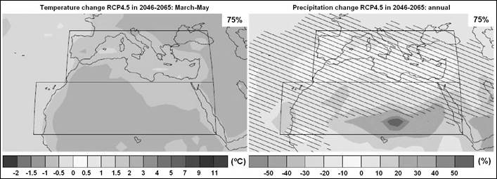
Figure 2 Maps of temperature and precipitation change for the RCP4.5 scenario (Stocker et al., 2014).
Uses and demands
To satisfy demands with resources according to the Coordinated Plan extracted from the Hydrological Plan that concerns the supply of water in Malaga, irrigation of the irrigable surface area, and the environmental requirements for the different planned horizons were determined (Table 4).
Table 4 Resources from different uses (hm3).
| Horizon | Use | Regulated | Surface runoff | Underground | Regenerate | Desalinated | Total | Total |
|---|---|---|---|---|---|---|---|---|
| Actual | Human supply | 34.98 | 17.24 | 6.85 | 59.07 | 136.31 | ||
| Irrigated area | 59.52 | 0.69 | 6.78 | 66.99 | ||||
| E. Flow | 10.25 | |||||||
| 2021 | Human supply | 40.43 | 16.62 | 7.09 | 64.14 | 135.95 | ||
| Irrigate area | 46.65 | 0.69 | 6.78 | 54.12 | ||||
| E. Flow | 17.69 | |||||||
| 2027 | Human supply | 46.97 | 14.61 | 6.24 | 67.82 | 139.61 | ||
| Irrigate area | 31.40 | 0.63 | 3.39 | 18.68 | 54.10 | |||
| E. Flow | 17.69 |
Economy
It is indisputable that agriculture must become sustainable, that is to say, it must meet the needs of present generations without compromising the needs of future generations (WCED, 1987). Sustainability is a multidisciplinary concept that encompasses environmental, social, and economic dimensions. It is necessary to advance sustainability indicators that help the agricultural sector in decisions surrounding productivity, the adoption of a specific technology, or the change of land use. Although scientific interest related to sustainability indicators in agricultural systems is increasing, it is also necessary to make purely economic calculations and then qualify the data with environmental or social aspects.
Drought cycles affect water availability. If the climate change prediction scenarios foreseen by the IPCC for the Mediterranean region are fulfilled, measures directed at limiting irrigation water quantity or investing to make water distribution more efficient to avoid losses.
The Leontief model was used to calculate total economic impact (Leontief, 1986) using the input-output tables available in Andalusia (2010; the last year available). The Leontief demand model is described as:
Y = [I-A] - 1xD
where Y is the total economic impact, [I-A]-1 is the inverse square matrix of regional technical coefficients (it is called the inverse matrix of Leontief), and D is the vector of direct income at basic agricultural prices.
Results and discussion
In the Guadalhorce River valley, and given that the productivity of the irrigable area in the valley is high, the first feasible economic approach was to determine the need for works of irrigation water abstraction and distribution in order to quantify the investments necessary to maintain or expand the irrigable area. According to ICRA data, the research area has an average annual income of 7 613 € ha-1. Of the total irrigable area (12 690 ha), 9 248 ha are irrigated, so the total income from this area amounts to 70 405 024 €. This is a direct impact. The total income from the irrigated area was calculated as 70 405 024 € (Table 5) and was necessary to estimate the D vector.
Table 5 Distribution of direct income.
| Factor | Income (€) | Percentage (%) |
|---|---|---|
| Agriculture, livestock, and fishing | 26 385 606.85 | 37.50 |
| Industry | 19 077 085.22 | 27.10 |
| Construction | 9 180 559.89 | 13.00 |
| Services | 15 761 772.03 | 22.40 |
| Total | 70 405 024.00 | 100.00 |
The inverse square matrix of regional technical coefficients was applied to the direct income vector. The result provided the distribution of production generated by different economic sectors (Table 6).
Table 6 Distribution of production generated by each economic sector.
| Factor | Total production | Indirect production | ||
|---|---|---|---|---|
| Income (€) | (%) | Income (€) | (%) | |
| Agriculture, livestock and fishing | 52 270 184.53 | 29.00 | 25 884 577.67 | 23.50 |
| Industry | 50 870 046.32 | 28.20 | 31 792 961.09 | 28.90 |
| Construction | 23 417 251.72 | 13.00 | 14 236 691.83 | 12.90 |
| Services | 53 973 715.42 | 29.90 | 38 211 943.39 | 34.70 |
| Total | 180 531 197.98 | 100.00 | 110 126 173.98 | 100.00 |
The irrigated area directly accounts for 70 million euros, which translates into 180.5 million of total economic impact. Any land-use change approach should take this economic activity into account since environmental sustainability must go hand in hand with social and economic sustainability. Any change in land use would require calculation and discounting of the impacts of the new use.
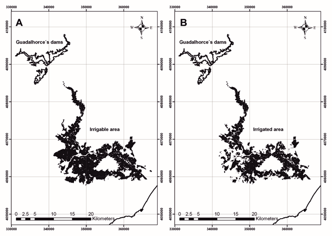
The irrigable area consisted of 12 690 ha split between irrigated and non-irrigated areas. Non-irrigated area covered a total of 3 442 ha, while the irrigated area was 9 248 ha (Figure 3).
The hydrological planning estimates for the 2021 and 2027 horizons project a decrease in demand for irrigation and an increase in the supply and environmental requirements to fulfill the environmental objectives of the water bodies in the research area. In the 2021 horizon, reduced irrigation demand resulted from improved irrigation efficiency while supply resources and environmental requirements increased. In the 2027 horizon, increased demand for water supplies was partly offset by resource contributions from regenerated water while resources were released from the system to improve water management and to continue meeting the environmental objectives of water bodies located in the research area (i.e., Water bodies are not sentient and therefore cannot have objectives. Humans have objectives for the management of water bodies).
However, according to climate change scenario predictions, data indicating reduced water contributions to some hydrologic systems in the southern region of the Iberian Peninsula (Jiménez-Fernández & Jiménez-Gavilán, 2014) and the increased prevalence of torrential rainfalls, it is possible to reduce contributions to the system by 25%. Together with forecasts of increased demand for urban water supply, water deficits will be generated in the area.
Conclusions
Updating of the irrigated area in the Coordinated Plan requires redefinition because of changes in the region during the more than 40 years since its approval and adoption into the new hydrological planning requirements with full entry into the Water Framework Directive. To compensate for the water resources deficits in this area in the future, new resources will require incorporation into the system. Due to the proximity of the research area to the sea, the best option is to construct a desalination plant in the coastal zone to supply the human population, which will guarantee supply under all potential future scenarios.
Deficits in irrigation water generated in less favorable climate change scenarios will be compensated by an increase in the proportion of regenerated resources together with desalination. Simultaneously, less resource-intensive crop varieties should be studied and adopted to reduce irrigation water demand and improve the efficiency of the system.
Classical economic evaluation methods, such as the one presented above, do not consider environmental and social implications. In order to have a true estimation of water resource and land-use planning governance impacts, environmental and social implications require quantification.

