


Services on Demand
Journal
Article
 text in
  English (pdf)
 Article in xml format
 Article references
 Send this article by e-mail
Indicators
-
 Cited by SciELO
 -
 Access statistics
Related links
-
 Similars in
SciELO
Similars in
SciELO
Share

 Permalink
Revista mexicana de ciencias forestales
Print version ISSN 2007-1132
Rev. mex. de cienc. forestales vol.14 n.80 México Nov./Dec. 2023 Epub Feb 05, 2024
https://doi.org/10.29298/rmcf.v14i80.1388
Scientific article
Effect of forest management on the physical-hydrological characteristics of the soil in a temperate forest
1
*
 http://orcid.org/0000-0002-4608-3361
1
http://orcid.org/0000-0002-1014-8784
1
http://orcid.org/0000-0002-4161-2105
1Universidad Autónoma del Estado de Hidalgo, Instituto de Ciencias Agropecuarias. México.
2Universidad Autónoma del Estado de Hidalgo, Instituto de Ciencias Básicas e Ingeniería. México.
The process of temperate forest harvesting generates reversible impacts on the soil by altering its properties, mainly due to the reduction of vegetation, as well as to cutting and dragging of wood, which causes an increase in apparent density and reduces infiltration. The objective of this study was to evaluate the effect of different forest management practices on the physical-hydrological properties of the soil and their relationship with water infiltration in temperate forest soils. The study areas were: recently intervened area, with the intervention dating back 18 years, and conservation area (control) in a temperate pine-oak forest under exploitation in the state of Hidalgo. The variables evaluated were bulk density and porosity (methodology proposed by USDA), granulometry (Bouyoucos method), and infiltration tests with the double-ring method. The results for bulk density were higher in the recently intervened area (0.62 g cm-3) and lower in the conservation area (0.32 g cm-3). Porosity in the conserved area was 11 % higher than in the recently intervened area (88 and 77 %, respectively). The infiltration rate in the conserved area was 2.641 cm min-1 compared to 0.655 cm min-1 in the area intervened 18 years ago. The authors conclude that the bulk density of the soil increases, while the porosity and infiltration capacity decrease with the implementation of harvesting activities ―a situation that gradually recovers with the establishment of new forests.
Key words Rainwater; bulk density; infiltration; water table; forestry; soil
El proceso de aprovechamiento del bosque templado genera impactos reversibles en el suelo al alterar sus propiedades, principalmente por la reducción de la vegetación, troceo y arrastre de la madera que ocasiona aumento en la densidad aparente y reduce la infiltración. El objetivo de este estudio fue evaluar el efecto de diferentes prácticas de manejo forestal sobre propiedades físico-hidrológicas del suelo y su relación con la infiltración del agua en los suelos de un bosque de clima templado. Las áreas de estudio fueron: área de reciente intervención, intervenida hace 18 años y área de conservación (testigo) en un bosque templado de pino-encino bajo aprovechamiento en el estado de Hidalgo. Las variables evaluadas fueron, densidad aparente y porosidad (metodología propuesta por USDA), granulometría (método de Bouyoucos) y pruebas de infiltración con el método de doble anillo. Los resultados de la densidad aparente fueron mayores en el área de reciente intervención (0.62 g cm-3) y menor en el área de conservación (0.32 g cm-3). La porosidad en el área conservada superó en 11 % al área de reciente intervención (88 y 77 %, respectivamente). La tasa de infiltración en el área conservada tuvo 2.641 cm min-1 en comparación con 0.655 cm min-1 del área intervenida hace 18 años. Se concluye que la densidad aparente del suelo se incrementa mientras que la porosidad y capacidad de infiltración disminuyen con la ejecución de las actividades de aprovechamiento, situación que se recupera en forma gradual con el establecimiento de los nuevos bosques.
Palabras clave Agua de lluvia; densidad aparente; infiltración; mantos acuíferos; silvicultura; suelo
Introduction
In Mexico, 36 % of the soils have no apparent degradation; this provides stability to ecosystems through good aeration, moisture retention with sufficient pore spaces that facilitate root penetration, and nutrients for the establishment and development of vegetation (Bolaños et al., 2016). The rest of the area (64 %) is affected by water erosion, wind erosion, and chemical degradation (Semarnat and CP, 2002). Other anthropogenic activities such as overgrazing, traditional agriculture, land use change, and population growth influence soil degradation by decreasing the infiltration rate of rainwater, which results in increased surface runoff (Turnbull et al., 2010; ONUAA, 2016; Béjar-Pulido et al., 2021), as well as in the alteration of water flows linked to forests (Pérez-Campomanes and Iannacone, 2020), which conditions the availability of water resources to supply the needs of the population (Chamizo-Checa et al., 2018), a situation that has worsened in recent decades due to climate change.
It has recently been recognized that forests provide environmental goods and services that contribute to human development (López-Hernández et al., 2017); among them is rainwater harvesting, which is sometimes affected by the unsustainable use of forest resources (Dourojeanni, 2020) when poor forestry management practices are applied (Endara and Herrera, 2016).
During the harvesting of temperate forests, temporary negative impacts are generated on the soil due to activities such as felling and logging of trees, dragging of logs, loading maneuvers, construction of forest roads and timber extraction (Dueñez-Alanís et al., 2006; Valladares-Samperio and Galicia-Sarmiento, 2021). These actions alter the properties of the soil in the first few months, as the vegetation cover is reduced, leaving the soil exposed to rainfall (Muñoz et al., 2013), which in turn causes an increase in the bulk density (Chaudhari et al., 2013), a reduction of the infiltration rate, and soil loss due to water erosion (Matías et al., 2020). In view of this, assessment of the effect of several forest management practices on the physical-hydrological properties of the soil and their relationship with water infiltration in the soils of a temperate forest was proposed.
Materials and Methods
Study area
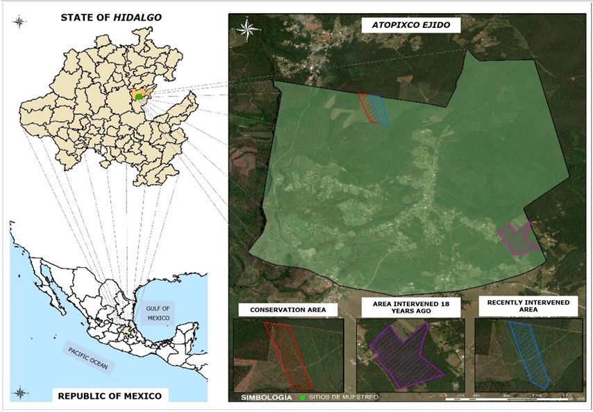
The study area is located in the highlands of the state of Hidalgo, between 20⁰36'11'' N and 98⁰36'28'' W, at an altitude of 2 048 m (Figure 1).
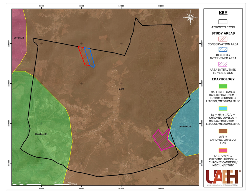
The climate of the area is of type C(m)a, which is a humid temperate climate with abundant rainfall in summer, the average annual temperature is 12.7 °C, and the annual precipitation is 1 278 mm (Cruz-Leyva et al., 2010). The study area is located in the hydrological region RH-26 Pánuco River, basin D the Montezuma River and sub-basin V, Metztitlán River. The predominant soil corresponds to a chromic Luvisol and the secondary one to a haplic Phaeozem (Figure 2) belonging to volcanic soils (INEGI, 1992).
The predominant vegetation corresponds to the pine-oak forest with species such as Pinus patula Schltdl. & Cham. (Mexican weeping pine), P. teocote Cham. & Schltdl. (teocote), Quercus rugosa Née (netleaf oak), Q. laurina Bonpl. (laurel oak), Q. laeta Liebm. (white oak), Q. crassifolia Bonpl. (leather-leaf Mexican oak), Alnus arguta (Schltdl.) Spach (alder) (Synonym of de Alnus acuminata subsp. arguta (Schltdl.) Furlow), Arbutus xalapensis Kunth (Texas madrone), Prunus serotina Ehrh. subsp. capuli (Cav.) McVaugh (wild black cherry), Clethra mexicana DC. (Mexican pepper bush), Crataegus mexicana DC. (Mexican hawthorn), Vaccinium leucanthum Schltdl. (huckleberry), Ternstroemia sylvatica Schltdl. & Cham (little trumpet), among others (Servicios Forestales de Hidalgo, 2011).
Treatments and conditions of the areas
The study was conducted in areas with similar soil type, topography, slope, and terrain exposure conditions within a forest property, but with different vegetation, as described below:
Conservation area. This corresponds to a stand with original pine-oak vegetation that has not been disturbed in over 50 years, and therefore it has a high diversity and density of trees that deposit considerable amounts of organic matter on the forest floor (Table 1).
Table 1 Dasometric data of the study areas.
| Study areas | Felling intensity (%) |
Average diameter (cm) |
Average height (m) |
Density (ha-1 trees) |
Basimetric area (m2 ha-1) |
|---|---|---|---|---|---|
| Conservation area | 0 | 42.50 | 25.70 | 165 | 23.41 |
| Area intervened 18 years ago | 25 | 12.50 | 10.00 | 1,665 | 20.43 |
| Area of recent intervention | 90 | 37.50 | 28.50 | 16 | 1.77 |
Area intervened 18 years ago. The vegetation conditions were similar to those of the conservation area, but with the forestry treatments applied 18 years ago, the vegetation cover was modified and gradually recovered until it reached its current pole stage, with a predominance of Pinus patula in high densities; in addition, secondary treatments of cleaning, pruning, pre-thinning, and thinning have been applied over time, allowing the incorporation of waste into the soil (Table 1).
Recently intervened area. This corresponds to the last harvesting area (year 2016), where the total vegetation, except for 16 trees ha-1, was eliminated from the application of the parent tree method. This caused impacts on some soil characteristics such as compaction due to the felling of trees, the dragging of logs, and the movement of logging trucks, as well as the modification of organic matter due to the control of waste from traditional logging in the area through spot burning with low risk of generating a forest fire (Table 1).
Sampling design
In each selected area, sampling sites with five replicates were established using a systematic design at distances of 150 m and a zigzag arrangement (Azañero et al., 2020). At each sampling point, infiltration tests were performed and soil samples were collected in order to determine the organic matter content, bulk density, porosity, and granulometry at the seed and soil laboratory of the Instituto de Ciencias Agropecuarias (Institute of Agricultural Sciences) of the Universidad Autónoma del Estado de Hidalgo (Autonomous University of the State of Hidalgo).
Measurement of variables
Organic matter content
The methodology summarized in Table 2 was applied in order to determine the organic matter (OM) content in the study areas.
Table 2 Methodology for the determination of organic matter.
| Variable | Method | Units | Author |
|---|---|---|---|
| Organic matter content | Walkley and Black | % | Walkley and Black (1934) |
The percentage of organic matter was estimated using the following formulas:
Where:
% OM = Percentage of organic matter
M = mL of FeSO4 0.5 N spent on the sample
B= mL of FeSO4 0.5 N spent on the target
The corresponding factor for the percentage of OM was calculated with the following expression:
Where:
1.0 = Normality of K2Cr2O7
1.72 = Conversion factor of carbon to OM
0.77 = 77 % recovery factor discovered by Walkey
SW = Sample weight (g)
Granulometry
In order to classify the soil particles, a composite sample was prepared (Vargas et al., 2021) for each study area, and the methodology described in Table 3 was subsequently applied.
Table 3 Composite sample and Bouyoucos method.
| Variable | Method | Units | Author |
|---|---|---|---|
| Sample | Composite sample | g | Vargas et al. (2021) |
| Granulometry | Bouyoucos | % | Silva et al. (2020) |
The following equations were used to estimate the particle size in terms of percentages of clay, silt and sand (Silva et al., 2020):
Where:
R1 = Hydrometer reading taken at 60 seconds
T1 = Temperature one ±1
R2 = Hydrometer reading taken after two hours
T2 = Temperature two ±1
After performing the respective calculations, the characterization of the percentage by means of the textural triangle was made in order to determine the granulometry corresponding to the soil of each study area (USDA, 1999).
Bulk density and porosity of the soil
Table 4 shows the open-bag methodology proposed by USDA (1999), which was utilized for bulk density (Bd) and soil porosity (P).
Table 4 Open-bag methodology proposed by USDA.
| Variable | Method | Units | Author |
|---|---|---|---|
| Densidad aparente | Open-bag | g cm-3 | USDA (1999) |
| Porosidad | % |
The following formula (USDA, 1999) was used to determine bulk density (Bd) and porosity (P):
Where:
Bd = Bulk density (g cm-3)
P = Soil porosity as a percentage
2.65 = Density constant of all minerals (g cm-3)
Infiltration tests
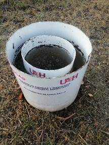
The double ring infiltration method (inner ring diameter: 25 cm, and outer ring diameter: 35 cm) was used to estimate the infiltration rates (Figure 3) as proposed by Chagoya et al. (2015), having been applied in the rainy season when the soil was at field capacity. Subsequently, the inner ring was buried to the ground at 15 cm and the outer ring at 25 cm; a sheet of water was then added at a constant level, and the descent of the water was measured as a function of time for two hours until the infiltration rate was constant for two hours (Zapata-Sierra and Manzano-Agugliaro, 2008). The Kostiakow model (Equation 8) was used to estimate the infiltration rate (Guerrero et al., 2016; Weber and Apestegui, 2016).
Where:
I = Accumulated infiltration
t = Accumulated time
(a) and (b) = Soil parameters
Statistical analyses
Soil physical parameter data (bulk density, porosity and soil infiltration capacity) from the three different study areas were analyzed by means of an analysis of variance (ANOVA) and Duncan's multiple range test (Rodríguez et al., 2020), in order to statistically identify significant differences. Data processing was performed with the statistical package Statistical Analysis System for Windows® (SAS Institute, 1985).
Results and Discussion
The percentage of soil organic matter (SOM) content ranged between 6.9 and 16.2 %; the areas that were intervened 18 years ago and the conservation area exhibited the highest and lowest SOM content with a medium and very high organic matter concentration range, respectively (Table 5), according to the NOM-021-SEMARNAT-2000 (Semarnat, 2002).
Table 5 Soil organic matter content and granulometry in three areas with different degrees of disturbance in a temperate forest.
| Study area | Conservation
area |
Area
intervened 18 years ago |
Recently
intervened area |
|
|---|---|---|---|---|
| Variables | ||||
| Organic matter (%) | 16.2 | 6.9 | 15.7 | |
| SOM concentration range | Very high | Medium | High | |
| Granulometry (%) | Clay | 9.4 | 17.4 | 11.4 |
| Silt | 17.2 | 24.5 | 28.5 | |
| Sand | 73.2 | 58 | 60 | |
| Texture class | Sandy-Loam | Sandy-Loam | Sandy-Loam | |
Some of the differences may be explained by the fact that the rate of humidification of organic matter is different in the recently intervened and conservation areas (leaf litter) compared to the area intervened 18 years ago (pine mulch). A similar situation was presented in the study conducted by Romero-Barrios et al. (2015) in a forest of sacred fir, pine and oak.
The granulometry is relative to the proportion of particles present in the soil; in the conservation area there were 9.4 % of clay and a maximum of 73.2 % of sand particles, while in the area intervened 18 years ago there were 17.4 % of clay and 58.0 % of sand (Table 5). Based on the texture triangle (USDA, 1999), the three areas that were evaluated in this research showed the sandy loam textural class (Table 5). These results are similar to those published by Cruz-Ruiz et al. (2012), who evaluated the effect on the edaphic characteristics of a temperate forest by land use change on the Northern slope of Nevado de Toluca National Park; their results indicated that the forest land use had a particle ratio of 6.8 % clay, 38.6 % silt, and 54.7 % sand. In a similar way, for a pine-oak forest of the Purépecha Plateau, state of Michoacán, Bayuelo et al. (2019) recorded 11.8 % clay particles, silt 16.0 % and sand 72.2 %, values which are very close to the results found in this study.
On the other hand, bulk density as a physical characteristic of the soil exhibited significant differences (F=3.17, P≤0.0782) between the evaluated areas. In the recently intervened area, a bulk density of 0.62 g cm-3 was recorded compared to 0.32 g cm-3 in the conservation area (Table 6). These results showed that in the areas of recent intervention, the soil was compacted up to 48.4 % more than in the other areas.
Table 6 Bulk density, porosity and infiltration capacity of the soil in three areas with different degrees of disturbance in a temperate forest.
| Study areas | Conservation
area |
Area
intervened 18 years ago |
Recently
intervened area |
|
|---|---|---|---|---|
| Variables | ||||
| Bulk density (g cm-3) | Medium | 0.32 a† | 0.54 ab | 0.62 b |
| Minimum | 0.23 | 0.31 | 0.33 | |
| Maximum | 0.39 | 0.68 | 1.06 | |
| Standard deviation +/- | 0.07 | 0.16 | 0.29 | |
| Porosity of the soil (%) | Medium | 88a† | 80ab | 77b |
| Minimum | 85 | 74 | 60 | |
| Maximum | 91 | 88 | 87 | |
| Standard deviation +/- | 0.02 | 0.06 | 0.11 | |
| Infiltration capacity (cm min-1) | Medium | 2.67 | 0.65 | 0.89 |
| Minimum | 1.13 | 0.18 | 0.04 | |
| Maximum | 6.27 | 0.98 | 1.54 | |
| Standard deviation +/- | 1.84 | 0.27 | 0.49 | |
†Equal letters in the same column indicate that there is no significant difference, according to Duncan's test (P≤0.05)
The results are lower than those documented by Romero-Barrios et al. (2015) in a study conducted for organic matter and bulk density in soils of the Southwest of the Malinche, Tlaxcala, Mexico, which records a bulk density of 1.5 g cm-3; however, they agree with the norm NOM-021-SEMARNAT-2000 (Semarnat, 2002) for organic and volcanic soils, whose bulk density must be less than 1 g cm-3. It is inferred that in the study areas, there is an adequate flow of water and gas exchange in the soil that favors the recharge of the aquifer in the region.
Another variable evaluated was porosity, which is directly related to bulk density. The results indicated significant differences (F=3.17, P≤0.0783) between the study areas. The conservation area had an average soil porosity of 88 %, while in the recently intervened area, it was 77 % (Table 6). Soil porosity data in the three evaluated areas showed that the impact generated was greater in the recently intervened area, with a range of 60 to 87 %.
The porosity values obtained in this study are similar to those recorded by González-Barrios et al. (2011), who report that pore spaces in forest soil are higher than 62 % of the total volume. On the other hand, in the Tangar district, in the Tyrumrud region of Hyrcanian forests (Iran), Jourgholami et al. (2019) estimated physical, chemical and biological soil indicators to evaluate the restoration of a compacted soil after reforestation, and obtained a maximum porosity of 57.31 % with four different treatments.
The analysis of the vertical infiltration test of the water resource in the forest soil indicated significant differences (F=3.95, P≤0.0481) between the areas. The infiltration capacity of the soil in the conservation area had an average rate of 2.67 cm min-1. The area of recent intervention recorded the lowest value of vertical water movement of 0.04 cm min-1 (Table 6). It should be added that the infiltration capacity of the soil in the conservation area ranged between 1.22 and 6.80 cm min-1 during the first 12 minutes, in the same time, the variations in the other two areas ranged from 0.06 to 2.78 cm min-1. From minute 14, the infiltration capacity was higher in the conservation area and tended to stabilize (1.84 to 3.03 cm min-1) after 120 minutes. However, for the recently intervened area, the infiltration capacity values were lower in the same period (0.55 to 1.13 cm min-1). Finally, it should be noted that the area intervened 18 years ago presented a lower infiltration capacity from minute 14 to 58 (Figure 4B), but experienced a significant increase from minute 60 onwards, with similar values (1.97 to 2.57 cm min-1) to those of the conservation area (Figure 4A).
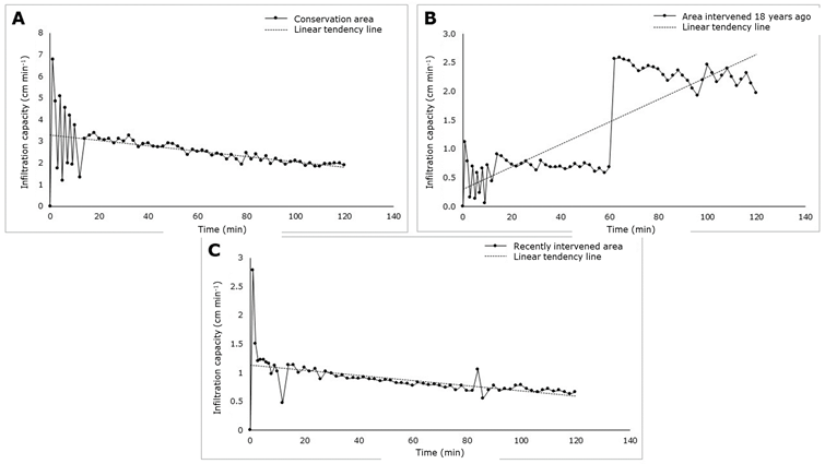
Figure 4 Behavior of the soil infiltration capacity (cm/min-1) in three areas with different degrees of disturbance in a temperate forest.
The results obtained in this work are similar to those documented by Lozano-Trejo et al. (2020) in a study conducted in the Southern basin of Mexico on infiltration and runoff of water in the soil, where they obtained a basic soil infiltration of 2.29 cm min-1 for a forest similar to the conservation area. Conversely, in a study on the factors that influence soil water erosion in a temperate forest, Matías et al. (2020) observed that pine vegetation can reach an infiltration of 0.19 cm min-1 (11.76 cm h-1); this data differs from that recorded in the present study. On the other hand, Monárrez-González et al. (2018) point out that forests under forest harvesting tend to recover their infiltration flow over time, after supply activities that cause a temporary impact on hydrological variables, as reflected in the results documented here.
Conclusions
The physical-hydrological characteristics of the forest soil are temporarily modified by the timber harvesting activities in temperate pine-oak forests, which increases the bulk density, reduces porosity, and diminishes the infiltration rate of water resources during a precipitation event.
During the establishment and development of the new forest stands resulting from harvesting, the forest soil tends to recover its physical and chemical conditions over time, which increases its porosity and rainwater infiltration capacity. This positive impact is attributed to the growth and development of the root system of the new vegetation, to the constant incorporation of organic matter, and to the microorganism populations present in the soil.
Acknowledgments
The authors are grateful to the Consejo Nacional de Humanidades, Ciencia y Tecnología, Conahcyt (National Council for Humanities, Science, and Technology) for the financial grant awarded to Josué Fabián Pérez Hernández, which made it possible to conduct this research.
REFERENCES
Azañero A., L., M. Ñique Á. y N. Florida R. 2020. Calidad del suelo en diferentes sistemas de uso en selva alta de Huánuco, Perú. Revista Tayacaja 3(1):112-125. Doi: 10.46908/rict.v3i1.75. [ Links ]
Bayuelo, J. J. S., I. Ochoa, E. de la Cruz T. y T. Muraoka. 2019. Efecto del uso del suelo en las formas y disponibilidad de fósforo de un Andisol de la Meseta P´urhépecha, Michoacán. Terra Latinoamericana 37(1):35-44. Doi: 10.28940/tl.v37i1.367. [ Links ]
Béjar-Pulido, S. J., I. Cantú-Silva, H. González-Rodríguez, J. G. Marmolejo-Moncivais, M. I. Yáñez-Díaz and E. O. Luna-Robles. 2021. Effect of land use change and agricultural management on physical and hydrological properties of an Andosol in Uruapan, Michoacán. Revista Chapingo Serie Ciencias Forestales y del Ambiente 27(2):323-335. Doi: 10.5154/r.rchscfa.2020.04.032. [ Links ]
Bolaños, M. A., F. Paz P., C. O. Cruz G., J. A. Argumedo E., V. M. Romero B. y J. C. de la Cruz C. 2016. Mapa de erosión de los suelos de México y posibles implicaciones en el almacenamiento de carbono orgánico del suelo. Terra Latinoamericana 34(3):271-288. http://www.scielo.org.mx/pdf/tl/v34n3/2395-8030-tl-34-03-00271.pdf . (20 de octubre de 2022). [ Links ]
Chagoya F., J. L., C. Mallén R., M. A. McDonald, F. Jiménez O., … y F. Becerra L. 2015. Información hidrológica, primer paso para diseñar una política local de pago por servicios ambientales . Revista Mexicana de Ciencias Forestales 6(29):24-43. http://www.scielo.org.mx/pdf/remcf/v6n29/v6n29a3.pdf (28 de octubre de 2022). [ Links ]
Chamizo-Checa, S., E. Otazo-Sánchez, A. J. Gordillo-Martínez, C. A. González-Ramírez, J. Suárez-Sánchez y H. Muñoz-Nava. 2018. El cambio climático y la disponibilidad agua en sub-cuencas del Valle del Mezquital, México. Revista Iberoamericana de Ciencias 5(5):40-51. http://www.reibci.org/publicados/2018/oct/3000102.pdf . (29 de noviembre de 2022). [ Links ]
Chaudhari, P. R., D. V. Ahire, V. D. Ahire, M. Chkravarty and S. Maity. 2013. Soil bulk density as related to soil texture, organic matter content and available total nutrients of Coimbatore soil. International Journal of Scientific and Research Publications 3(2):1-8. https://citeseerx.ist.psu.edu/viewdoc/download?doi=10.1.1.299.7022&rep=rep1&type=pdf . (8 de enero de 2023). [ Links ]
Cruz-Leyva, I. A., J. R. Valdez-Lazalde, G. Ángeles-Pérez y H. M. de los Santos-Posadas. 2010. Modelación espacial de área basal y volumen de madera en bosques manejados de Pinus patula y P. teocote en el ejido Atopixco, Hidalgo. Madera y Bosques 16(3):75-97. https://www.scielo.org.mx/pdf/mb/v16n3/v16n3a6.pdf . (12 de enero de 2023). [ Links ]
Cruz-Ruiz, E., A. Cruz-Ruiz, L. I. Aguilera-Gómez, H. T. Norman-Mondragón, … y B. G. Reyes-Reyes. 2012. Efecto en las características edáficas de un bosque templado por el cambio de uso de suelo. Terra Latinoamericana 30(2):189-197. http://www.scielo.org.mx/pdf/tl/v30n2/2395-8030-tl-30-02-00189.pdf . (5 de enero de 2023). [ Links ]
Dourojeanni, M. J. 2020. ¿Es sostenible el aprovechamiento maderero de bosques naturales en el Perú? Revista Forestal del Perú 35(2):80-93. Doi: 10.21704/rfp.v35i2.1577. [ Links ]
Dueñez-Alanís, J., J. Gutiérrez, L. Pérez and J. Návar. 2006. Manejo silvícola, capacidad de infiltración, escurrimiento superficial y erosión. Terra Latinoamericana 24(2):233-240. https://www.redalyc.org/pdf/573/57311108010.pdf . (17 de octubre de 2022). [ Links ]
Endara A., Á. R. y F. Herrera T. 2016. Deterioro y conservación de los bosques del Nevado de Toluca y el rol de los actores locales. CIENCIA ergo-sum 23(3):247-254. https://dialnet.unirioja.es/servlet/articulo?codigo=5713913 . (10 de octubre de 2022). [ Links ]
González-Barrios, J. L., G. González-Cervantes, I. Sánchez-Cohen, A. López-Santos y L. M. Valenzuela-Núñez. 2011. Caracterización de la porosidad edáfica como indicador de la calidad física del suelo. Terra Latinoamericana 29(4):369-377. http://www.scielo.org.mx/scielo.php?script=sci_arttext&pid=S0187-57792011000400369 . (18 de febrero de 2023). [ Links ]
Guerrero A., A. M., N. Tornés O., O. Brown M. y Y. Gómez M. 2016. Evaluación de tres modelos en la estimación de la infiltración acumulada. Revista Ingeniería Agrícola 6(3):41-47. https://revistas.unah.edu.cu/index.php/IAgric/article/view/826/859 . (15 de diciembre de 2022). [ Links ]
Instituto Nacional de Estadística, Geografía e Informática (INEGI). 1992. Síntesis geográfica del estado de Hidalgo. INEGI. Aguascalientes, Ags., México. 136 p. [ Links ]
Jourgholami, M., T. Ghassemi and E. R. Labelle. 2019. Soil physio-chemical and biological indicators to evaluate the restoration of compacted soil following reforestation. Ecological Indicators (101):102-110. Doi: 10.1016/j.ecolind.2019.01.009. [ Links ]
López-Hernández, J. A., Ó. A. Aguirre-Calderón, E. Alanís-Rodríguez, J. C. Monarrez-Gonzalez, M. A. González-Tagle y J. Jiménez-Pérez. 2017. Composición y diversidad de especies forestales en bosques templados de Puebla, México. Madera y Bosques 23(1):39-51. Doi: 10.21829/myb.2017.2311518. [ Links ]
Lozano-Trejo, S., J. Olazo-Aquino, M. I. Pérez-León, E. Castañeda-Hidalgo, G. O. Díaz-Zorrilla y G. M. Santiago-Martínez. 2020. Infiltración y escurrimiento de agua en suelos de una cuenca en el sur de México. Terra Latinoamericana 38(1):57-66. Doi: 10.28940/terra.v38i1.443. [ Links ]
Matías R., M., J. D. Gómez D., A. I. Monterroso R., M. Uribe G., … y C. Asencio. 2020. Factores que influyen en la erosión hídrica del suelo en un bosque templado. Revista Mexicana de Ciencias Forestales 11(59):51-71. Doi: 10.29298/rmcf.v11i59.673. [ Links ]
Monárrez-González, J. C., G. Pérez-Verdín, C. López-González, M. A. Márquez-Linares y M. del S. González-Elizondo. 2018. Efecto del manejo forestal sobre algunos servicios ecosistémicos en los bosques templados de México. Madera y Bosques 24(2):e2421569. Doi: 10.21829/myb.2018.2421569. [ Links ]
Muñoz I., D. J., M. Ferreira R., I. B. Escalante A. y J. López G. 2013. Relación entre la cobertura del terreno y la degradación física y biológica de un suelo aluvial en una región semiárida. Terra Latinoamericana 31(3):201-210. http://www.scielo.org.mx/pdf/tl/v31n3/2395-8030-tl-31-03-00201.pdf . (22 de noviembre de 2022). [ Links ]
Organización de las Naciones Unidas para la Alimentación y la Agricultura (ONUAA). 2016. Evaluación de los recursos forestales mundiales 2015 ¿Cómo están cambiando los bosques del mundo? ONUAA. Roma, RM, Italia. 44 p. http://www.fao.org/3/i4793s/i4793s.pdf . (21 de diciembre de 2022). [ Links ]
Pérez-Campomanes, G. y J. Iannacone. 2020. Impacto del cambio climático en la disponibilidad de las aguas superficiales en Sudamérica. Paideia XXI 10(1):173-202. Doi: 10.31381/paideia.v10i1.2981. [ Links ]
Rodríguez D., I., H. I. Pérez I., R. M. García B. y A. J. Quezada M. 2020. Efecto del manejo agrícola en propiedades físicas y químicas del suelo en diferentes agroecosistemas. Revista Universidad y Sociedad 12(5):389-398. http://scielo.sld.cu/pdf/rus/v12n5/2218-3620-rus-12-05-389.pdf . (23 de febrero de 2023). [ Links ]
Romero-Barrios, C., E. García-Gallegos y E. Hernández-Acosta. 2015. Materia orgánica y densidad aparente en suelos del suroeste de La Malinche, Tlaxcala, México. Revista Iberoamericana de Ciencias 2(5):63-70. http://www.reibci.org/publicados/2015/septiembre/1200108.pdf . (27 de enero de 2023). [ Links ]
Secretaria de Medio Ambiente y Recursos Naturales (Semarnat) y Colegio de Postgraduados (CP). 2002. Evaluación de la degradación del suelo causada por el hombre en la República Mexicana. Escala 1:250 000. Memoria Nacional 2001-2002. Semarnat y CP. Texcoco, Edo. Méx., México. 69 p. https://www.researchgate.net/publication/307967321_SEMARNAT-CP_2003_Memoria_Nacional_2001,2002_Evaluacion_de_la_Degradacion_del_Suelo_causada_por_el_Hombre_en_la_Republica_Mexicana_escala_1250000_Memoria_Nacional . (27 de noviembre de 2022). [ Links ]
Secretaría de Medio Ambiente y Recursos Naturales (Semarnat). 2002. NORMA Oficial Mexicana NOM-021-RECNAT-2000, Que establece las especificaciones de fertilidad, salinidad y clasificación de suelos. Estudios, muestreo y análisis. Diario Oficial de la Federación, 31 de diciembre de 2002. México D. F., México. 73 p. http://www.ordenjuridico.gob.mx/Documentos/Federal/wo69255.pdf . (14 de enero de 2023). [ Links ]
Servicios Forestales de Hidalgo (Serforh). 2011. Estudio Regional Forestal de la Unidad de Manejo Forestal 1302 “Zacualtipán-Molango”. Serforh S. C. y Asociación de Productores Forestales de la Región Zacualtipán-Molango, A. C. Mineral de la Reforma, Hgo., México. 423 p. http://www.conafor.gob.mx:8080/documentos/docs/9/2943Estudio%20Regional%20Forestal%201302..pdf . (18 de diciembre de 2022). [ Links ]
Silva P., A., B. A. Rodríguez R. y N. Vargas A. 2020. Análisis textural en la regulación de funciones ecosistémicas en sistemas agroforestales de un oxisol de Piedemonte Llanero en época seca, Colombia. Idesia 38(3):43-51. Doi: 10.4067/S0718-34292020000300043. [ Links ]
Statistical Analysis System Institute (SAS). 1985. SAS/STAT Guide for Personal Computers, Version 6 Edition. SAS Institute. Ann Arbor, MI, United States of America. 378 p. [ Links ]
Turnbull, L., J. Wainwright and R. E. Brazier. 2010. Changes in hydrology and erosion over a transition from grassland to shrubland. Hydrological Processes 24(4):393-414. Doi: 10.1002/hyp.7491. [ Links ]
United States Department of Agriculture (USDA). 1999. Guía para la evaluación de la calidad y salud del suelo. USDA. Washington, DC, Estados Unidos de América. 82 p. https://www.nrcs.usda.gov/sites/default/files/2022-10/Gu%C3%ADa%20para%20la%20Evaluaci%C3%B3n%20de%20la%20Calidad%20y%20Salud%20del%20Suelo.pdf . (6 de enero de 2023). [ Links ]
Valladares-Samperio, K. and L. Galicia-Sarmiento. 2021. Impacts of forest management on soil properties: a fundamental research topic for Mexico. Revista Chapingo Serie Ciencias Forestales y del Ambiente 27(1):33-52. Doi: 10.5154/r.rchscfa.2019.11.088. [ Links ]
Vargas D., R. E., J. R. Galindo P. y R. Giraldo H. 2021. Análisis espacial de propiedades físicas del suelo de la Hoya del Río Suárez, Boyacá-Santander (Colombia), utilizando componentes principales. Investigación Agraria 23(1):8-16. Doi: 10.18004/investig.agrar.2021.junio.2301657. [ Links ]
Walkley, A. and I. A. Black. 1934. An examination of the Degtjareff method for determining soil organic matter, and a proposed modification of the chromic acid titration method. Soil Science 37(1):29-38. Doi: 10.1097/00010694-193401000-00003. [ Links ]
Weber, J. F. y L. Apestegui. 2016. Relaciones entre parámetros de los modelos de infiltración de Kostiakov y Lewis-Kostiakov, Córdoba, Argentina. Tecnología y Ciencias del Agua 7(2):115-132. http://www.scielo.org.mx/pdf/tca/v7n2/2007-2422-tca-7-02-00115.pdf . (12 de enero de 2023). [ Links ]
Zapata-Sierra, A. y F. Manzano-Agugliaro. 2008. Influencia de seis especies arbóreas en la infiltración de agua en el suelo. Agrociencia 42(7):835-845. http://www.scielo.org.mx/pdf/agro/v42n7/v42n7a10.pdf . (19 de diciembre de 2022). [ Links ]
Received: February 01, 2023; Accepted: October 10, 2023
 Este es un artículo publicado en acceso abierto bajo una licencia
Creative Commons
Este es un artículo publicado en acceso abierto bajo una licencia
Creative Commons
