


Services on Demand
Journal
Article
 text in
  English (pdf)
 Article in xml format
 Article references
 Send this article by e-mail
Indicators
-
 Cited by SciELO
 -
 Access statistics
Related links
-
 Similars in
SciELO
Similars in
SciELO
Share

 Permalink
Revista mexicana de ciencias forestales
Print version ISSN 2007-1132
Rev. mex. de cienc. forestales vol.14 n.79 México Sep./Oct. 2023 Epub Oct 06, 2023
https://doi.org/10.29298/rmcf.v14i79.1356
Scientific article
Temporary analysis of land use in a Ramsar site (No. 1981) in central Nuevo León
1Universidad Autónoma de Nuevo León, Facultad de Ciencias Forestales. México.
2Instituto Tecnológico de Estudios Superiores de Monterrey, Laboratorio de Sistemas de Información Georreferenciada. México.
The ecosystem services provided by wetlands are central to the sustainability of societies through their contribution to food supply and climate regulation. The gradual deterioration of these ecosystems exacerbates the environmental crisis and the deterioration of water quality. Ramsar Sites were created for the protection of the world's wetlands, with the aim of preserving the integrity and maintenance of their biological character. This study presents the situation of Ramsar Site No. 1981 which is in north-eastern Mexico, using satellite images and land use maps, land use change is accounted for a period of 44 years analysed in three temporal snapshots: 1975, 2003 and 2019. The flooded area decreased by 84 %, scrubland decreased by 36 % and agricultural area increased by 547 %, and grassland by 284 %. The area increased at the expense of floodplain cover, possibly caused by prolonged periods of drought over the last few decades. It is essential to recognise that Mexico has not legislated specifically for the protection of Wetlands, therefore decree a system of Ramsar is not enough to stop or reverse the processes of environmental degradation. It is necessary to improve the management of existing laws and develop an adaptive management plan subject to hydrological changes due climate change, inadequate watershed management and lack of natural cover.
Key words Agriculture; land use change; conservation; wetland; Mexico; Ramsar
Los servicios ecosistémicos de los humedales son fundamentales para la sustentabilidad de las sociedades por su aporte alimentario y regulación del clima; su gradual deterioro agudiza la crisis ambiental y disminuye la calidad del agua. Los sitios Ramsar fueron creados para la protección de los humedales del Planeta, con el objetivo de preservar la integridad y el mantenimiento de sus características biológicas. Este estudio describe la situación del Sitio Ramsar Núm. 1981 ubicado al noreste de México. Con apoyo de imágenes con vista satelital y mapas de uso de suelo, se contabilizó el cambio de uso de suelo por un periodo de 44 años, analizado en tres instantáneas temporales: 1975, 2003 y 2019. Se comprobó una reducción substancial del humedal y su zona de influencia. Se registró una pérdida de 84 % en área inundable, el matorral decreció 36 % y la zona agrícola y el pastizal incrementaron su superficie en 547 % y 284 %, respectivamente. Dicho aumento ocurrió a expensas del área inundable, posiblemente causado por los prolongados periodos de sequía durante las últimas décadas. Es importante reconocer que en México no se ha legislado específicamente para la protección de los humedales, por lo que decretar un sitio Ramsar no es suficiente para frenar o revertir los procesos de deterioro ambiental. Es necesario mejorar la gestión de las leyes vigentes y desarrollar un plan de manejo adaptativo sujeto a los cambios hídricos provocados por el cambio climático, el manejo inadecuado de las cuencas y la falta de cobertura natural.
Palabras clave Agricultura; cambio de uso de suelo; conservación; humedal; México; Ramsar
Introduction
Wetlands are ecosystems that, from their origin, shape, biodiversity, water and biogeochemical system, are classified as unique; they are also considered transition ecosystems between aquatic and terrestrial systems (Cowardin et al., 1979), and intervene directly or indirectly in the global water cycle (Convención de Ramsar sobre los Humedales, 2018). The ecosystem services that they provide place them in a central part for the sustainability of some societies, since fish products, algae, rice, fiber and other direct and indirect inputs are obtained from them. Only in 2020, 214 million tons of fishery products were obtained from wetlands, which yielded $ 151 billion US dollars for the same year (FAO, 2022).
Other intrinsic goods to wetlands are linked to social and cultural well-being, as confirmed by studies on water recycling, recreational and aesthetic satisfaction, climate regulation, transmission of knowledge values, among others (Rochgiyanti and Susanto, 2017; Clarke et al., 2021; Agaton y Guila, 2023).
The contribution of wetland services, however, is at risk on a global scale, due to the continuous conversion of this ecosystem towards "other productive uses", for which, frequently, they are drained or modified for agricultural uses or human settlements (Amenu and Mamo, 2018). Stopping or reversing negative impacts on wetlands requires global action, for this reason, in 1971 the Convention on Wetlands (Ramsar Convention) was created, which became effective in 1975. The central objective of this agreement between countries is the conservation and rational use of wetlands, based on the idea of rational use as the maintenance of their ecological characteristics. The Ramsar Convention identifies wetlands of international relevance, especially those that provide habitat for waterfowl (Ramsar, 2023a).
According to the Ramsar website, Mexico currently has 144 sites designated as wetlands of international importance (Ramsar sites), covering an area of 8 721 911 ha (Ramsar, 2023b), which is equivalent to 1.69 % of its total territorial surface. They represent wetlands of different origin and water regulation, seven of them are located in Northeastwen Mexico (Ramsar, 2023c); site No. 1981 (Figure 1) stands out for being a source of sulfurous waters that are home to endemic species of fish and habitat for migratory birds, such as the sandhill crane (Antigone canadensis, Linnaeus 1758) (eBird, 2023). In addition, it is an emblem in region, its hydrogeochemical system is unique in Nuevo León and allows the formation of microbial mats (Chacón-Baca et al., 2015), as well as the presence of endemic ichthyo-species (Lozano-Vilano et al., 2021), however, agricultural and livestock pressure has modified its landscape in recent decades (Benítez, 1997).
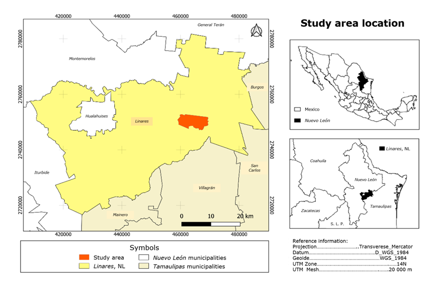
Ramsar Site No. 1981.
Figure 1 Geographical location of the study site in the Linares municipality, Nuevo León.
The scarce information that is generated in Mexico about wetlands, specifically inland (not coastal), increases the uncertainty of its future. The present study focuses on analyzing the change in land use at the Ramsar No. 1981 site (Figure 1) in a period of 44 years (1975 to 2019), in order to determine the deterioration and significant changes that modify its surface and identify disturbances in its area of influence.
Materials and methods
Study area
The study area was decreed as a Zone Subject to Ecological Conservation (ZSCE, for its acronym in Spanish) on November 24th, 2000 and covers an area of 4 225.40 hectares; it consists of a wetland that includes a hydrothermal spring of sulfurous waters surrounded by a natural floodable grassland (Cantú, 2001). A community of Tamaulipan Thorny Scrub develops on the southern margins of the grassland. In 2009, the entire ZSCE was declared a Ramsar Site (Cantú, 2009).
Delimitation of the study area
A Raster Tile layer was imported from the Open Street Map (2021) website, which contains the polygon of Ramsar Site No. 1981. In QGIS 3.32.2 (QGIS Development Team, 2021) a vector layer was created vector in ESRI® Shapefile format (.shp) with polygon geometry and WGS 84/UTM Zone 14N projection. In it, the study area was drawn with the "add polygon" tool that was supported by the green lines marked by the OpenStreetMap map (Figure 2).

The green outline shows the polygon of the Ramsar Site. Blue barred area represents the body of water.
Figure 2 OpenStreetMap image used in the delimitation of the Ramsar Site No. 1981.
To verify that the surface was correct, the field calculator tool was used. Because this program works with meters as the default unit, the formula $area/10 000 was used in the field calculator to express the value obtained in hectares. The resulting value was 4 225.40 hectares, which agrees with the surface established as the study area and validates the polygon created.
Data sources for land use change
The approximation of the current state of the Ramsar No. 1981 wetland was obtained by comparing images with a satellite view and a map of land use and vegetation from the year 1975 obtained from the Natural Protected Area Management Program (Cantú et al., 2001). This was extracted in JPG format from its original format (PDF). From the attributes contained in this map, the types of vegetation that are managed in this study were selected (Table 1). To quantify the changes that occurred over time, images with a satellite view were used, corresponding to the years 2003 and 2019 dated July and August, respectively (closest dates available) that were obtained from the publicly available Google Earth® platform. The selection criteria was based on the oldest and most recent image, with a resolution of 15 meters per pixel, sufficient for the discrimination of the types of land use, thus generating JGP images with the maximum accepted resolution (4 000×2 000 pixels). To achieve the images, the study area polygon layer was loaded in SHP format into Google Earth Pro® software (Mendenhall and Wrona, 2018; Gabrielli et al., 2020). Subsequently, the aerial view (of the selected dates) was positioned on the polygon of the study area and each image was exported in JPG format. This format does not include geographic coordinates, so all images generated with this format were georeferenced. To facilitate this process, each image obtained from Google Earth® was exported with a polygon layer visible from the study area, using the vertices of the polygon as control points. The georeferencing was carried out using the "Georeferencing" tool, selecting a type of transformation and linear sampling and the EPSG projection was assigned: 32 614-WGS 84/UTM Zone 14N. The georeferenced product was exported in GeoTIFF raster format and had an error of 20.73 m. The rasters thus generated were loaded into QGIS 3 and a color saturation filter of +100 was applied to the 2003 and 2019 satellite views. This increase in saturation allows a better distinction with the naked eye of the coverages and other elements of the landscape.
Table 1 Reclassification scheme for the 1975 land use and vegetation map.
| Original classification (1975) | Reclassification |
|---|---|
| Tamaulipan Thorny Scrub | Scrubland |
| Submontane Scrub | Scrubland |
| Mesquital | Scrubland |
| Grassland | Grassland |
| Irrigation agriculture | Agricultural area |
| Rainfed agriculture | Agricultural area |
| Body of water | Body of water |
| Swamp | Floodable area |
Land use classification
To match the classification of vegetation between the years 1975, 2003 and 2019, land use and vegetation cover were reclassified (Table 1).
Analysis of coverage changes
The 1975-2003 and 2003-2019 temporal coverage changes were analyzed with the Land Change Modeler for Ecological Sustainability (LCM) tool available in IDRISI Selva 17.0 (Clark Labs, 2022). It follows a standardized methodology to analyze land use and vegetation change patterns (Humacata, 2019; Gupta and Sharma, 2020). Raster layers in RST format were previously generated from the SHP vector layers with values from 1 to 7, assigning a value to each type of land coverage (Table 2). The background surface of the image (no data) was assigned the value 0.
Table 2 Assigned values to each land coverage to be processed by the IDRISI “Land Change Modeler” tool.
| Coverage | Assigned value |
|---|---|
| Agricultural | 1 |
| Scrubland | 2 |
| Grassland | 3 |
| Floodable area | 4 |
| Water | 5 |
| Infrastructure | 6 |
| Without apparent vegetation | 7 |
All images used must have the same format, extension, projection system, geometry, and category (Eastman, 2012). This procedure results in graphs and maps with evaluation of loss, gain and persistence changes in native IDRISI format, which in this case, were later exported to IMG format for evaluation in a geographic information system.
Checking differences in coverage
The area values expressed in hectares obtained from the vector layers were entered into the PAST statistical package (Natural History Museum, 2021) to perform a X 2 test for contingency tables (Hausner et al., 2015). The test contrasts observed frequencies with the expected frequencies according to the null hypothesis and is used to calculate the strength of the association between the data.
Results
In the year 1975 there are no records of the presence of the class without apparent vegetation (WAV) and infrastructure, due to the lack of detail in the map of origin, however, it is feasible to appreciate the substantial reduction and increase in the natural coverage of the site and the expansion of anthropic activity (Table 3; Figure 3).
Table 3 Area of the type of coverage for the years 1975, 2003 and 2019, expressed in hectares and percentage with respect to the total area.
| Coverage | Surface area (ha) | Surface area (%) | ||||
|---|---|---|---|---|---|---|
| 1975 | 2003 | 2019 | 1975 | 2003 | 2019 | |
| Agricultural | 252.86 | 1 138.53 | 1 384.53 | 5.98 | 26.94 | 32.76 |
| Scrubland | 3 414.16 | 2 490.62 | 2 185.40 | 80.80 | 58.95 | 51.72 |
| Grassland | 157.80 | 445.95 | 447.81 | 3.73 | 10.55 | 10.60 |
| Infrastructure | 0.00 | 10.79 | 13.62 | 0.00 | 0.26 | 0.32 |
| Water | 0.23 | 1.22 | 1.08 | 0.01 | 0.03 | 0.03 |
| Floodable area | 400.35 | 79.62 | 70.08 | 9.48 | 1.88 | 1.66 |
| WAV | 0.00 | 58.87 | 123.23 | 0.00 | 1.39 | 2.92 |
| Total | 4 225.40 | 4 225.40 | 4 225.40 | 100 | 100 | 100 |
WAV = Without Apparent Vegetation.

The most outstanding changes are shown in Figure 3. In it, it can be seen that the most notable occur with the loss of scrub cover and floodable area for an increase of the same magnitude in agricultural and grassland areas, respectively; they occur mainly in the period from 1975 to 2003 (Figure 3a-3h). The minimal or little apparent changes are presented in bodies of water, infrastructure and WAP for the periods analyzed (Figure 3i-3n).
The analysis of the change in land use between the years 1975 and 2003 (Figure 4) shows relevant modifications of scrub cover (-22 %), floodable area (-7.6 %), grassland (+7 %) and agricultural area (+twenty-one %). Minor change in water and infrastructure and moderate in WAV.
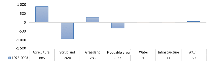
WAV = Without Apparent Vegetation. Negative values indicate a loss in coverage type.
Figure 4 Coverage changes at Ramsar Site No. 1981 during the 1975-2003 period, expressed in hectares.
The agricultural expansion continued during the period between 2003 and 2019, with an increase of 7 % and the same proportion of loss for scrubland. The grassland and water remained without significant changes in their coverage, as well as infrastructure and the flood zone (0.22 %), WAV was modified in small amounts (2 %) (Figure 5).

WAV = Without Apparent Vegetation.
Figure 5 Coverage changes at Ramsar Site No. 1981 during the 2003-2019 period, expressed in hectares.
The total changes in coverage that occurred in a period of 44 years (1975-2019) are considerable, as shown in Figure 6. The largest increases occur in agriculture (from 253 to 1 384 ha) and grassland (158 to 448 ha), which contrasts with the notorious loss of scrub (from 3 414 to 2 185 ha) and floodable area (from 400 to 70 ha). Small gains are shown for infrastructure (11 to 14 ha) and water (0.23 to 1 ha).
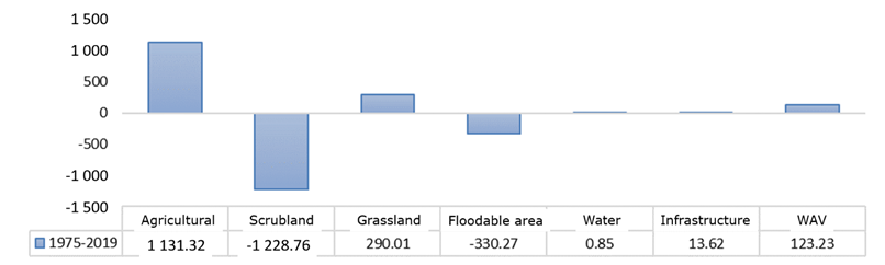
WAV = Without Apparent Vegetation.
Figure 6 Total coverage changes at Ramsar Site No. 1981 over a 44-year period (1975-2019).
The changes observed in the mentioned period are significant in most land use classes (p=0.000001; Table 4). Only the bodies of water (water) remained without apparent modification, probably because they were supplied mostly underground.
Table 4 Residual p values of the X 2 contingency table (12 degrees of freedom).
| 1975 | 2003 | 2019 | |
|---|---|---|---|
| Agricultural | 5.0101E-195* | 8.934E-21* | 2.268E-93* |
| Scrubland | 4.5364E-167* | 6.1467E-15* | 3.1081E-87* |
| Grassland | 3.206E-40* | 4.4711E-11* | 1.9156E-11* |
| WAV | N/a | N/a | 1.8855E-23* |
| Water | 0.3155E | 0.61493 | 0.6153 |
| Floodable area | 8.5039E-91* | 9.050132E-22* | 1.855E-25* |
| Infrastructure | N/a | N/a | 0.017788* |
WAV = Without Apparent Vegetation. N/a = Not applicable.
Discussion
The results confirm a significant loss of coverage at the Ramsar Site No. 1981. An almost extinction of the floodable area was verified by losing 84 % of its surface and being replaced by grassland. The expansion of the agricultural frontier was the cause of the loss of scrub (36 %), initially occupying 6 % of the total surface of the area up to 33 % in 2019. In addition to the loss of the original cover and in accordance with the generated images, a modification of the landscape is noticed, mainly in the vicinity of what was previously the floodable area, which probably interrupted the natural flow of water towards the floodable area and the pools, which also modified the levels of evaporation and erosion protection.
This degradation and modifications in the Ramsar Site No. 1981 agree with other investigations carried out in Mexican wetlands, in which desiccation and loss of native cover due to the effects of urbanization, agriculture, aquaculture and industry are mentioned (Merlín-Uribe et al., 2012; Castellanos-Navarrete, 2021; Ballut-Dajud, 2022), a process that occurs in most of these ecosystems in the world (Convención de Ramsar sobre los Humedales, 2018). The foregoing coincides with was mentioned by Benítez (1997), who states that the greatest change in land use in the study area was due to an increase in agricultural areas, and confirms that the reduction in scrub cover was caused due to clearing, the selective extraction of woody elements and extensive overgrazing practices.
To date, the most successful cases of recovery of the ecological integrity of these sites involve the inclusion of local residents who use the resources generated by these ecosystems. An example of this are the Rarámuri communities and the landowners in Chihuahua State, where together with NGO´s, they raise awareness among the local population to optimize the use of water from the groundwater table and store rainwater to avoid water stress, carry out concrete actions to mitigate the erosion (living fences) (Briggs et al., 2020) and/or vary agricultural practices (Sarkar et al., 2020). Empowering direct stakeholders based on the resource and the quality of life that wetlands provide seems to be the best way to conserve and perpetuate the environmental services linked to this ecosystem (Rochgiyanti and Susanto, 2017; Pedersen et al., 2019).
The governance of the Ramsar Site No. 1981 is essential to recover its biological integrity, which must be inclusive, transparent and equitable with the populations in the area of influence (Mauerhofer, 2015); their activities have a direct impact on hydrology by verifying that the use of peripheral land notoriously fragmented the landscape.
The use of water for agricultural purposes also has an important impact on its hydrology, due to changes in the flow caused by agricultural areas, as has been reported in the past for other regions (McCauley and Jenkins, 2005). More detailed studies are required to know the underground water supply of the Ramsar Site No. 1981. The loss of native vegetation and the gain of agricultural surface reflect the lack of concrete actions that are observed in the National Wetlands Policy, whose objective is to conserve the hydrological basins and their biological component (Semarnat, 2018). This is a reflection of legislation rarely observed, in addition to not being specific to these ecosystems and which unfortunately does not present comprehensive and cross-cutting actions, which makes coordination for their conservation difficult (CEDRSSA, 2021).
A quick review of the historical satellite images available in Google Earth® and the consultation of the historical precipitation data from the Cerro Prieto weather station (1950-2010) (Servicio Meteorológico Nacional, 2011), confirm a prolonged drought during the last decades, which potentially influenced the water system, drying out the soil and evaporating surface water. The hydric changes experienced in recent decades due to inadequate management expose the risks of climate change and deforestation, including the loss of endemic species (Lozano-Vilano et al., 2021), the reduction of semi-aquatic plant species present in the flooded areas such as Carex L. spp. and Cyperus L. spp., confirm the loss of biological diversity that gradually occurs in the site.
Pérez (2017) proposed that the underground flow that controls the Ramsar Site No. 1981 site has its origin in the Sierra Madre Oriental (SMO), which is consistent with the conclusions of Cantú and González (2002) that mention the importance of oak, pine and pine-oak forests for runoff and water use in the SMO. This binding information makes it clear that the conservation of vegetation covers in the basin where the Ramsar Site No. 1981 is located is a priority if the objective is to preserve its functionality.
According to Landgrave and Moreno-Casasola (2012), Mexico has lost 62 % of its wetlands, and Nuevo León is one of the states with the greatest decline (>50 %). At present there is no study that updates the conditions of these sites in the country; the National Inventory of Wetlands compiles and integrates the most complete database, however, there is no periodic monitoring of them at the national level. Therefore, the small or large contributions provided by studies such as this one will help to identify their current state, mainly those in the interior (non-coastal), whose information is very scarce.
It is essential to recognize that a Ramsar system (or Protected Natural Area) is not enough to stop or reverse the processes of environmental deterioration. Specific laws and actions are required to guarantee the perpetuity of freshwater reservoirs. Protected natural areas are subject to various threats (Maass et al., 2010). In addition, they are vulnerable to the management schemes of their adjacent surfaces, and even within the same protected area due to the fact that on many occasions, there is inappropriate infrastructure within them, which occurs in the Ramsar Site No. 1981 when increasing in 3 ha the existing infrastructure. Part of the study site has gone from being an ejidal property to a private one, specifically the flood prone area and part of the scrub that surrounds it, which isolates the main pool and the smaller pools from the wetland.
The first action was to surround the property and restrict the passage of the public and ejidatarios in general, which sends the wrong signal to the inhabitants of the area. Socially, disconnecting the local population from the actions that are carried out does little to favor their conservation, since the basin that supplies water to the wetland is essential. An approach with the main actors of the rural settlements will allow finding holistic solutions that benefit all those involved and pay off in the recovery of the site.
Establishing clear management and use actions that are compatible and pertinent with the Ramsar declaration would avoid the continuous growth of the agricultural frontier in the protected area, in addition, the conservation of the vegetation cover of the basin would reduce the water stress detected and supply those wetlands present.
Conclusions
The results prove a significant change in the landscape structure of the Ramsar Site No. 1981 during the period from 1975 to 2019. The drastic reduction in the floodable area reflects the lack of surface water flow, as well as the low soil saturation, which subsequently produces a slight reduction of water in the main pool of the wetland.
Although the exposed results show clear variations between the periods analyzed with the near extinction of the floodable area (16 % remaining). The absence of quality information currently makes it difficult to carry out work with a high degree of precision in the study area. Added to this, is the owner's unwillingness to grant permission to obtain field data, which makes it difficult to corroborate in situ the aforementioned losses. However, what is exposed in this study is worrying, due to the low groundwater levels, as the water level of the main pool decreases and small springs within the site become extinct. The loss of scrub alters runoff and water infiltration, agriculture increases the albedo of the area and with it evaporation, coupled with a prolonged drought that accentuates the gradual loss of surface area of the wetland.
The basin is still under anthropic pressure, whether due to agriculture, livestock or use of groundwater tables, ordering activities within the basin is a priority. At the moment there is no management program that focuses on the current situation of climate change and land use, its protection is a priority to conserve not only the hydrology of the basin, but also to protect the biota present and that depends on sulfur ecosystems. and hot springs.
Promoting specific laws for both coastal and inland wetlands will be a task for the current and future legislatures, as well as supporting basic research on monitoring and inventory of wild populations dependent on these ecosystems. The current scenario makes it clear that the established policies hardly benefited our study area, however, each water reservoir is a priority for the health and quality of life of the inhabitants of Mexico.
Acknowledgements
The auhors are greatful to Celina Garza Quintanilla and Rosalía Chávez Garza for their support in translating the Abstract. To the reviewers of this work for their contribution to the improvement of this publication.
REFERENCES
Agaton, C. B. and P. M. C. Guila. 2023. Ecosystem services valuation of constructed wetland as a nature-based solution to wastewater treatment. Earth 4(1):78-92. Doi: 10.3390/earth4010006. [ Links ]
Amenu, B. T and G. S. Mamo. 2018. Review on wetland ecosystem destruction. International Journal of Scientific Research in Civil Engineering 2(2):5-15. https://ijsrce.com/IJSRCE182202 . (20 de julio de 2021). [ Links ]
Ballut-Dajud, G. A., L. C. Sandoval H., G. Fernández-Lambert, J. L. Marín-Muñiz, M. C. López M. and E. A. Betanzo-Torres. 2022. Factors affecting wetland loss: a review. Land 11(3):434. Doi: 10.3390/land11030434. [ Links ]
Benítez G., M. C. 1997. Contribución a la caracterización ecológica y socioeconómica de la región "Baño de San Ignacio". Tesis de Maestría en Ciencias Forestales. Facultad de Ciencias Forestales, Universidad Autónoma de Nuevo León. Linares, NL, México. 136 p. [ Links ]
Briggs, M. K., E. A. Lozano-Cavazos, H. M. Poulos, J. Ochoa-Espinoza and J. A. Rodríguez-Pineda. 2020. The Chihuahuan Desert: A binational conservation response to protect a global treasure. In: Goldstein, M. I. and D. A. DellaSala (Edits.). Encyclopedia of the World´s Biomes. Elsevier Inc. Amsterdam, NH, Netherlands. pp. 126-138. [ Links ]
Cantú A., C. 2009. Ficha Informativa de los Humedales de Ramsar (FIR)-Versión 2009-2012: Baño de San Ignacio. Facultad de Ciencias Forestales y Universidad Autónoma de Nuevo León. Linares, NL, México. 23 p. https://rsis.ramsar.org/RISapp/files/RISrep/MX1981RIS.pdf . (1 de septiembre de 2021). [ Links ]
Cantú S., I. y H. González R. 2002. Propiedades hidrológicas del dosel de los bosques de pino-encino en el noreste de México. Ciencia UANL 5(1):72-77. http://eprints.uanl.mx/972/1/propied_hidrol.pdf . (8 de febrero 2023). [ Links ]
Cantú, C., R. Guerra, F. González y L. Rocha. 2001. Programa de Manejo del Área Natural Protegida Baño de San Ignacio. Gobierno del Estado de Nuevo León y Universidad Autónoma de Nuevo León. Monterrey, NL, México. 145 p. https://archive.org/details/programa-de-manejo-anp-bsi/ . (20 de julio de 2021). [ Links ]
Castellanos-Navarrete, A. 2021. Oil palm dispersal into protected wetlands: Human-environment dichotomies and the limits to governance in south Mexico. Land Use Policy 103:1-13. Doi: 10.1016/j.landusepol.2021.105304. [ Links ]
Centro de Estudios para el Desarrollo Rural Sustentable y la Soberanía Alimentaria (CEDRSSA). 2021. Importancia, Protección, Conservación de los Humedales. CEDRSSA y Cámara de Diputados LXV Legislatura. Venustiano Carranza, Cd. Mx., México. 23 p. http://www.cedrssa.gob.mx/files/10/89Importancia,%20protecci%C3%B3n,%20conservaci%C3%B3n%20de%20los%20humedales.pdf . (29 de octubre 2021). [ Links ]
Chacon-Baca, E., L. Alba-Aldave, S. Angeles y C. Cantú-Ayala. 2015. Tapetes microbianos recientes en el manantial hidrotermal de Baño San Ignacio, Linares, Nuevo León. Boletín de la Sociedad Geológica Mexicana 67(3):387-400. Doi: 10.18268/BSGM2015v67n3a3. [ Links ]
Clark Labs. 2022. TerrSet 2020 Software Features (Versión 17.0). Worcester, MA, United States of America. Universidad Clark. http://www.clarklabs.org . (30 de mayo 2023). [ Links ]
Clarke, B., A. K. Thet, H. Sandhu and S. Dittmann. 2021. Integrating cultural ecosystem services valuation into coastal wetlands restoration: A case of study from South Australia. Environmental Science and Policy 116:220-229. Doi: 10.1016/j.envsci.2020.11.014. [ Links ]
Convención de Ramsar sobre los Humedales. 2018. Perspectiva mundial sobre los humedales: Estado de los humedales del mundo y sus servicios a las personas. Secretaría de la Convención Ramsar. Gland, VD, Suiza. 84 p. https://www.ramsar.org/sites/default/files/documents/library/gwo_s.pdf . (4 de octubre de 2021). [ Links ]
Cowardin, L. M., V. Carter, F. C. Golet and E. T. LaRoe. 1979. Classification of wetlands and deepwater habitats of the United States. United States Department of the Interior and Fish and Wildlife Service. Washington, DC, United States of America. 131 p. [ Links ]
Eastman, J. R. 2012. IDRISI Selva, Guía para SIG y procesamiento de imágenes. Universidad Clark. Worcester, MA, Estados Unidos de América. 321 p. [ Links ]
eBird. 2023. Grulla gris. The Cornell Lab of Ornithology. https://ebird.org/species/sancra?siteLanguage=es_MX . (20 de febrero de 2023). [ Links ]
Food and Agriculture Organization of the United Nations (FAO). 2022. The state of world fisheries and aquaculture 2022. Towards Blue Transformation. FAO. Rome, RM, Italy. 236 p. [ Links ]
Gabrielli, S., M. Spagnolo and L. De Siena. 2020. Geomorphology and surface geology of Mount St. Helens volcano. Journal of Maps 16(2):585-594. Doi: 10.1080/17445647.2020.1790048. [ Links ]
Gupta, R. and L. K. Sharma. 2020. Efficacy of spatial land change modeler as a forecasting indicator for anthropogenic change dynamics over five decades: A case study of Shoolpaneshwar Wildlife Sanctuary, Gujarat, India. Ecological Indicators 112(274):106171. Doi: 10.1016/j.ecolind.2020.106171. [ Links ]
Hausner, V. H., G. Brown and E. Lægreid. 2015. Effects of land tenure and protected areas on ecosystem services and land use preferences in Norway. Land Use Policy 49:446-461. Doi: 10.1016/j.landusepol.2015.08.018. [ Links ]
Humacata, L. 2019. Análisis espacial de los cambios de usos del suelo. Aplicación con Sistemas de Información Geográfica. Revista Cartográfica (98):239-257. Doi: 10.35424/rcarto.i98.149. [ Links ]
Landgrave, R. y P. Moreno-Casasola. 2012. Evaluación cuantitativa de la pérdida de humedales en México. Investigación Ambiental 4(1):19-35. https://biblat.unam.mx/es/revista/investigacion-ambiental-ciencia-y-politica-publica/articulo/evaluacion-cuantitativa-de-la-perdida-de-humedales-en-mexico . (29 de octubre 2021). [ Links ]
Lozano-Vilano, M. L., A. J. Contreras-Balderas, G. Ruiz-Campos and M. E. García-Ramírez. 2021. Current conservation status of some freshwater species and their habitats in México. In: Propst, D. L., J. E. Williams, K. R. Bestgen and C. W. Hoagstrom (Edits). Standing between life and extinction: Ethics and ecology of conserving aquatic species in North American Deserts. The University of Chicago Press. Chicago, IL, United States of America. pp.:79-88. [ Links ]
Maass, M., E. Jardel, A. Martínez-Yrizar, L. Calderón, … y M. Equihua. 2010. Las áreas naturales protegidas y la investigación ecológica de largo plazo en México. Ecosistemas Revista Científica y Técnica de Ecología y Medio Ambiente 19(2):69-83. https://www.revistaecosistemas.net/index.php/ecosistemas/article/view/47 . (3 de marzo 2023). [ Links ]
Mauerhofer, V., R. E. Kim and C. Stevens. 2015. When implementation works: A comparison of Ramsar Convention implementation in different continents. Environmental Science and Policy 51:95-105. Doi: 10.1016/j.envsci.2015.03.016. [ Links ]
McCauley, L. A. and D. G. Jenkins. 2005. GIS-based estimates of former and current depressional wetlands in an agricultural landscape. Ecological Applications 15(4):1199-1208. https://stars.library.ucf.edu/facultybib2000/5468 . (3 de marzo 2023). [ Links ]
Mendenhall, C. D. and A. M. Wrona. 2018. Improving tree cover estimates for fine-scale landscape ecology. Landscape Ecology 33:1691-1696. Doi: 10.1007/s10980-018-0704-2. [ Links ]
Merlín-Uribe, Y., A. Contreras-Hernández, M. Astier-Calderón, O. P. Jensen, R. Zaragoza and L. Zambrano. 2012. Urban expansion into a protected natural area in Mexico City: alternative management scenarios. Journal of Environmental Planning and Management 56(3):1-14. Doi: 10.1080/09640568.2012.683686. [ Links ]
Natural History Museum. 2021. Past (Version 4.12). Oslo, O, Norway. University of Oslo. https://www.nhm.uio.no/english/research/resources/past/ . (14 de octubre de 2021). [ Links ]
OpenStreetMap. 2021. OpenStreetMap (Área Natural Protegida Baño de San Ignacio). Fundación OpenStreetMap. https://www.openstreetmap.org/#map=13/24.8594/-99.3478 . (1 de agosto de 2021). [ Links ]
Pedersen, E., S. E. B. Weisner and M. Johansson. 2019. Wetland areas´ direct contributions to residents´ well-being entitle them to high cultural ecosystem values. Science of the Total Environment 646:1315-1326. Doi: 10.1016/j.scitotenv.2018.07.236. [ Links ]
Pérez A., X. J. 2017. Estudio geofísico para la determinación de la estructura geológica en los alrededores del Baño San Ignacio, Linares, Nuevo León. Tesis de Maestría en Ciencias Geológicas. Facultad de Ciencias de la Tierra, Universidad Autónoma de Nuevo León. Linares, NL, México. 101 p. [ Links ]
QGIS Development Team. 2021. QGIS (Version 3.32.2). Geographic Information System. https://qgis.org . (5 de mayo de 2021). [ Links ]
Ramsar. 2023a. La Convención sobre los Humedales y su misión. https://www.ramsar.org/es/acerca-de/la-convencion-sobre-los-humedales-y-su-mision . (5 de febrero de 2023). [ Links ]
Ramsar. 2023b. México, la Convención sobre los Humedales. https://www.ramsar.org/es/humedal/mexico . (20 de febrero de 2023). [ Links ]
Ramsar. 2023c. Servicio de Información sobre Sitios Ramsar. https://rsis.ramsar.org/es. (27 de marzo 2023). [ Links ]
Rochgiyanti, M. and H. Susanto. 2017. Transformation of wetland local wisdom values on activities of Swamp Buffalo Breeding in Social Science Learning Practice. Advances in Social Science, Education and Humanities Research 147:272-276. Doi: 10.2991/icsse-17.2018.62. [ Links ]
Sarkar, P., M. Salami, Y. Githiora, R. Vieria, … and M. Padgurschi. 2020. A conceptual model to understand the drivers of changes in tropical wetlands: a comparative assessment in India and Brazil. Biota Neotropica 20:e20190913. Doi: 10.1590/1676-0611-BN-2019-0913. [ Links ]
Secretaría de Medio Ambiente y Recursos Naturales (Semarnat). 2018. ANP, corazón del patrimonio natural de México. https://www.gob.mx/semarnat/es/articulos/inedito-21-de-junio-articulo-central-anp-corazon-del-patrimonio-natural-de-mexico-mas-de-90-millones-de-has-resguardan-porciones-terrestres-acuaticas-e-insulares-de-importancia-para-la-conservacion-de-la-biodiversidad-desde-tiempos-remotos-ya-s?idiom=es#:~:text=Las%20ANP%20son%20zonas%20del,sujetas%20al%20r%C3%A9gimen%20previsto%20en . (2 de febrero de 2023). [ Links ]
Servicio Meteorológico Nacional. 2011. Normales Climatológicas, Nuevo León, 1951-1910, Estación 00019011 Cerro Prieto. Comisión Nacional del Agua. https://smn.conagua.gob.mx/tools/RESOURCES/Normales5110/NORMAL19011.TXT . (15 de octubre de 2021). [ Links ]
Received: March 13, 2023; Accepted: July 21, 2023
 Este es un artículo publicado en acceso abierto bajo una licencia
Creative Commons
Este es un artículo publicado en acceso abierto bajo una licencia
Creative Commons
