


Services on Demand
Journal
Article
 text in
  English (pdf)
 Article in xml format
 Article references
 Send this article by e-mail
Indicators
-
 Cited by SciELO
 -
 Access statistics
Related links
-
 Similars in
SciELO
Similars in
SciELO
Share

 Permalink
Revista mexicana de ciencias agrícolas
Print version ISSN 2007-0934
Rev. Mex. Cienc. Agríc vol.11 n.4 Texcoco May./Jun. 2020 Epub Sep 13, 2021
https://doi.org/10.29312/remexca.v11i4.2459
Articles
Vegetation management of the western sierras and plains municipality of Catorce, San Luis Potosí
1Maestría en Agroforestería para el Desarrollo Sostenible-Universidad Autónoma Chapingo. Carretera México-Texcoco km 38.5, Chapingo, Estado de México, CP. 56230. (diaz.candido.005@gmail.com; diodorog@hotmail.com; migueluribe123@gmail.com).
2Preparatoria Agrícola-Universidad Autónoma Chapingo.
Plant community management can use multivariate methods to find response patterns and generate hypotheses about possible relationships in species composition with respect to environmental gradients. The objective was to record patterns of distribution and uses of vegetation in the municipality of Catorce, San Luis Potosi. In 2019, six transects were shown, from the foot of the undergrowth to the west of the Sierra de Catorce, an endorheic drainage valley or plain and a low mountain range folded with a hill. Floristic composition, vertical and horizontal structure, and soil characteristics were analyzed at each site. Desert thickets of rosetophile, microphile and thorny forest were found. The indirect environmental factors that best explain the distribution are the porosity of the soil, pH, K, Ca, Fe and altitude, factors that influence the availability of water. The main use of plants is traditional medicinal.
Keywords: arid zones; synecology; Wirikuta
La ordenación de comunidades vegetales puede usar métodos multivariados para hallar patrones de respuesta y generar hipótesis sobre las posibles relaciones existentes en la composición de especies con respecto a gradientes ambientales. El objetivo fue registrar patrones de distribución y usos de la vegetación en el municipio de Catorce, San Luis Potosí. En 2019, se muestrearon seis transectos, desde pie de monte bajo al oeste de la Sierra de Catorce, valle o planicie de drenaje endorreico y sierra baja plegada con lomerío. En cada sitio se analizó la composición florística, la estructura vertical y horizontal y las características del suelo. Se hallaron matorrales desérticos rosetófilo, micrófilo y bosque espinoso. Los factores ambientales indirectos que mejor explican la distribución son la porosidad del suelo, pH, K, Ca, Fe y altitud, factores que influyen en la disponibilidad de agua. El principal uso de las plantas es medicinal tradicional.
Palabras clave: sinecología; Wirikuta; zonas áridas
Introduction
Desert is that area of land whose biological potentials are severely limited by water scarcity, with rainfall <250 mm annually and generally high temperatures (Granados, 2012). The availability of water and the physical factors related to it are essential and explain the variation in the distribution patterns of the vegetation in these, Schlesinger (1998); Pavón (2000) maintains that the distribution of shrubs in desert habitats, it is strongly correlated with the presence of N, P and K in the soil, because the biogeochemical cycle of these elements is concentrated under its canopy in ‘fertility islands’.
The largest arid region on the American continent is the Chihuahuan Desert (DC), an ecoregion located on a triangular plain, in northern Mexico between the Sierra Madre Oriental, Sierra Madre Occidental and the Eje Neovolcanico, which extends to New Mexico and Texas. It is estimated that in DC there are 324 cacti species, 30% of those on the planet, most of them endemic (Rzedowski, 1994), recognizing San Luis Potosi (SLP) as the state with the greatest diversity of species, with 151 of the total 826 taxa registered in the DC, 560 (67.8%) are endemic, 165 (20%) quasi-endemic and 176 (21.6%) micro-endemic (Villarreal, 2017).
With 17 genera of cacti (43.6%) and 229 species (70%) restricted to DC, the rate of endemism in this region is outstanding (Hernández, 2004). The western sierras and plains of the municipality of Catorce, are an arid area of great interest for vegetation studies, due to their composition of endemic species, of restricted distribution and in danger of extinction; also its topography, edaphology and the permanent deterioration they have suffered, are subjects of peculiar interest in this protected natural area (ANP) under the status of ‘natural sacred site’ that houses an exceptional biocultural heritage.
This project is a first stage that seeks to obtain basic synecological information for the design of a traditional medicinal agroforestry system in a second stage. The objective of this investigation was to use multivariate techniques to identify vegetation distribution patterns along environmental gradients in the valleys and western plains of the municipality of Catorce, San Luis Potosí (SLP).
Materials and methods
The research was carried out in the western sierras and plains subprovince, Catorce municipality, SLP. It is part of the Mesa del Centro physiographic province, to the west of the Sierra de Catorce (SC), in the SE quadrant of the DC ecoregion, southeast of the Potosino-Zacatecan altiplano, in the NW portion of SLP, in valleys and plains endorheic drainage intermountains formed mainly by gravel, clays and sands, which form forced accumulation structures with the fluvial transport of SC materials. The types of climate at the study site are arid-temperate (BSokw) and very arid-temperate (BWkw).
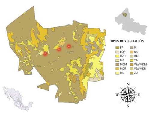
The predominant soils in the plains located on the East and West flanks of the SC are xerosols, soils characterized by their superficial layer of light material with low organic matter content (CONANP, 2012). Field trips were made to determine the types of vegetation; through an altitudinal gradient (1 600-1 910 m), three main sampling areas were established based on the observed plant associations: the microfil desert scrub (MDM) in the valley, rosetophilous desert scrub (MDR) in the low sierra and open mesquite forest or thorny forest (BE) at the foot of the SC mount. A map of vegetation types (Figure 1) of the municipality of Catorce was prepared, indicating the three chosen sampling sites, for which the ArcGis 10.3 program was used.
Six sampling transects were made, for each type of community observed, parallel, with a distance of 3 km from each other. The sampling method used to characterize the plant communities quantitatively was central point and quadrants (Brush, 1980), with 10 sampling points (60 points in total and 240 quadrants). With this sampling, parameters such as dominance, density and frequency, both absolute and relative, and relative importance value (VIR) were obtained.
At each sampling point, the floristic composition (perennial and annual) was also recorded at a 10 x 10 m site (60 sites). Plants that could not be identified in the field were collected and pressed for subsequent identification in the herbarium of Agricultural Preparatory, Autonomous University Chapingo (UACH). At the sites, composite soil samples (1 kg) were also obtained from each of the plant associations (MDM, MDR and BE).
The samples were sent to the Central Soil Laboratory of the Autonomous University Chapingo (UACH) for the determination of: pH (potentiometric), inorganic N (extracted with 2N potassium chloride and determined by steam entrainment), P assimilable (Olsen), K (extracted in 1N ammonium acetate, pH 7, 1:20 ratio and determined by flame emission spectrophotometry), Fe (extracted with DTPA in a 1:4 ratio and determined by atomic absorption spectrophotometry), Ca (extracted in 1N ammonium acetate, pH 7, ratio 1:20
Determined by atomic absorption spectrophotometry), texture (Bouyoucos hydrometer). Vegetation management was of two types: 1) indirect management through cluster analysis, constructing the groupings in sets of high internal similarity or dissimilarity, taking into account the members of other groups. The structure of the classification obtained from the similarity matrix was represented in a dendrogram (Rocha, 2006). For the numerical classification of the vegetation by means of groupings based on distance measurements and group joining methods, the SPSS V23.0 program was used.
This classification was made based on qualitative variables, based on binary attributes (presence, absence) and was an agglomerative political model. A total of 78 species were included. The groups were formed using the Jaccard index as a distance measure, and as the union algorithm the average between groups; and 2) direct ordering using canonical correspondence analysis (ACC), which is a technique that represents a special case of multiple regression, where the composition of the species is directly related to the environmental variables (Gonzáles, 2003) the CANOCO calculation program was used to carry out the analysis and its graphic representation was prepared using the CANODRAW program (Braak, 1998). The relative importance value of the species was estimated and a physiognomic profile was prepared to describe the communities; the Lumion program was used.
The communities were described based on the literature (Granados, 2012; González-Costilla, 2007; CONANP, 2012) and on field trips with key actors (producers, gatherers, sellers of medicinal plants, botanists, and medicinal plant specialists), who were also interviewed about the use of plants, particularly medicinal.
Results and discussion
Correspondence analysis
Indirect ordering or correspondence analysis (AC) of the species in the six sampled transects is presented in a dendrogram (Figure 2). Three plant associations are generally appreciated, choosing 41% of the information (mean) as the cut level. The first association is of MDM (transects 1 and 2), located in the valley between the SC and Sierra Baja, at 1 600 meters above sea level north of the community

La Borrega. The second type of vegetation (transects 5 and 6) is the BE, located at the foot of the SC mountain, at 1 770 meters above sea level, in the community of San Cristobal. The third group (transects 3 and 4) is the MDR, distributed in sierra baja with lomerio, at 1910 masl NE of the El Tecolote community.
In AC the multidimensional space is reduced, preserving the distances between the objects (vegetation samples), making it possible to determine the correspondence between the columns (sampling transects) and the rows (species) of the data matrix (de la Cruz, 1991). Table 1 presents the proximity or correspondence values between the species and sampling transects for the first management axes.
Table 1 Correspondence values between species and transects for the management axes.
Proximity matrix | ||||||
Objects |
S1 |
S2 |
S3 |
S4 |
S5 |
S6 |
S1 |
|
|
|
|
|
239 |
S2 |
923 |
|
|
|
|
250 |
S3 |
400 |
443 |
|
|
|
277 |
S4 |
412 |
456 |
821 |
|
|
246 |
S5 |
239 |
250 |
277 |
246 |
|
1 |
S6 |
239 |
250 |
277 |
246 |
0.996 |
1 |
In Figure 3 it is possible to visualize that sampling transects 1 and 2 are located very close to each other, this means that the transects share a large number of species, similarly, sampling transects 3 and 4 have a close proximity, thus like transects 5 and 6.

Microphile desert scrub, La Borrega community
The MDM of this site is located 10 km W of SC in the western sierras and plains subprovince, in an endorheic drainage valley, made up of haulage material, mainly gravel, clay and sand. It is located at the coordinates 23° 43’ 52.5” north latitude and 101° 04’ 46.0” west longitude, at 1 600 masl, it has a PMA of 311 mm, the climate is arid-temperate (BSokw), with warm summer, TMA from 12 to 18 °C, that of the coldest month between -3 and 18 °C and that of the warmest month >18 C, summer rains, from 5 to 10% per year.
Soils have the following characteristics: pH (7.78), N (3.8 mg kg-1), P (22.81 mg kg-1), K (490 mg kg-1), Ca (6 721 mg kg-1), Fe (2.37 mg kg-1). The soil is sandy loam (54.4% sand, 29.3% silt and 16.4% clay). The content of organic matter and the texture of the soil obtained coincide with the results of CONANP (2012), in which it is indicated that this plain (with xerosol soils) is characterized by presenting a superficial layer of clear material, due to the low organic matter content.
In an evaluation along a permanent transect (three years), that crosses an endorheic basin in the N portion of the DC, in south-central New Mexico, it was determined that the shrub layer dominated by Larrea tridentata D. Burckhardt, it extended in the xeric portion, very low in nitrogen; perennial grasses with C4 photosynthetic path, shrubs with C3 path and herbaceous plants were co-dominant at intermediate sites along the gradient (Cornelius, 1991).
This scrub is characterized by the dominance of small-leaved shrub species, crass and ephemeral plants that develop along alluvial fans, plains, slopes, valleys and soft hills, its main distribution being valleys, where the soils are textured fine, deep to relatively deep and have a layer of rocks (Granados, 2012).
In this scrub 28 species distributed in 12 families were identified, of which Cactaceae and Asteraceae were the most representative, with 9 and 6 species, respectively (Table 1) of the supplementary material. Six species are endemic, one is threatened and two are under special protection.
A richness of cacti of 10 species was found, Cylindropuntia imbricata (Haw.) F. M. Knuth, Cylindropuntia leptocaulis J. Jones, Echinocactus horizonthalonius J. Daniel, Echinocactus platyacanthus R. F. del Castillo, Echinocereus enneacanthus D. Sanchez, Echinocereus pectinatus N. P. Taylor, Escobaria dasyacantha D. R. Hunt, Ferocactus hamatacanthus J. Y. Clark, F. latispinus J. H. Cota, F. pilosus N. P. Taylor, F. stainesii R. S. Wallace, Lophophora williamsii E. F. Anderson, Opuntia rastrera J. A. Reyes-Agüero and Opuntia tunicata A. C. Gibson.
The analysis of relative importance value (VIR) is presented in Table 2, where the species with the highest VIR are seen: L. tridentata, followed by C. leptocaulis, Jatropha dioica B. Dehgan, O. tunicata, F. cernua M. O. Dillon and E. enneacanthus. A photo of the community and a semi-realistic physiognomic profile are shown in Figure 4a and 4b).
Table 2 Values of importance for the species of the MDM, La Borrega community, Catorce municipality.
Species |
ABMZ |
AAY |
FAX |
DAW |
ARV |
FRU |
DRT |
VIRS |
Larrea tridentata |
10.9 |
29 |
26 |
50 |
24.2 |
22.6 |
22.6 |
23.1 |
Cylindropuntia leptocaulis |
4.4 |
19 |
14 |
29.9 |
15.8 |
13.2 |
6 |
11.7 |
Jatropha dioica |
8.5 |
10 |
7 |
15.8 |
8.3 |
6.6 |
6.1 |
7 |
Opuntia tunicata |
23.3 |
6 |
6 |
12.1 |
5 |
5.7 |
10 |
6.9 |
Flourensia cernua |
10 |
8 |
8 |
15 |
6.7 |
7.6 |
5.7 |
6.6 |
Echinocereus enneacanthus |
25.2 |
5 |
5 |
10.1 |
4.2 |
4.7 |
9 |
6 |
Z= Average basal area; Y= absolute abundance; X= absolute frequency; W= absolute dominance; V= relative abundance; U= relative frequency; T= relative dominance; S= relative importance value.
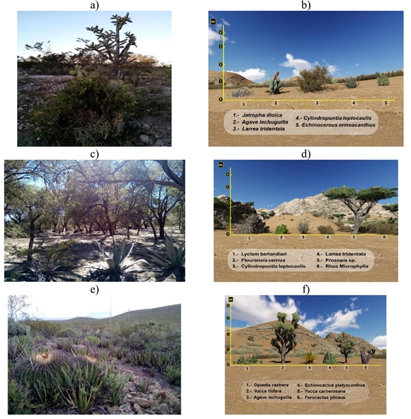
Figure 4 a) species of the MDM in the La Borrega community; b) semi-realistic profile; c) Mezquitales of the municipality of Catorce; d) semi-realistic profile, San Cristobal community; e) MDR, El Tecolote community, municipality of Catorce; and f) Semi-realistic profile of the MDR.
The results obtained are analogous to the description made in the analysis of the vascular flora, carried out in the SC and adjacent territories (González-Costilla, 2007), in which this area is described as a formation dominated by the species Larrea tridentata, Parthenium incanum G. K. Brizicky, Zinnia acerosa A. M. Torres, Flourensia cernua, Opuntia imbricata, Opuntia leptocaulis, Prosopis laevigata M. C. Johnston and Fouquieria splendens M. Baker. According to Marroquin (1964), the dominant layer in this type of scrub is the shrub layer and frequently includes L. tridentata and F. cernua.
Thorny forest, San Cristobal community
The BE is located on the edge of the Sierra Madre Oriental and Mesa del Centro physiographic provinces. Located at the foot of the scrubland, 6 km west of the SC, in valleys and intermountain plains with endoreic drainage, made up of structures of forced accumulation. This is where the so-called sandy substrate beach usually occurs at 1770 meters above sea level. The TMA is 16.6 °C, with a maximum of 37 °C and a minimum of -7 °C. The PMA is 311 mm.
The climate is considered temperate-dry (BS0 hx’), the driest of the BS, semi-warm with intermediate rainfall, cool winter and winter precipitation greater than 18% (SEDUVOP, 2006). This area is classified as a fertile surface with agricultural potential, with the availability of underground water, whose salinity is high and low in sodium. However, it is also classified as an open mesquite site with a high degree of erosion, due to the action of the wind, and sandy soil. It is located on the northern limit of the ANP, so its agricultural expansion compromises the conservation of the site.
Soil have the following characteristics: pH (7.31), N (26.3 mg kg-1), P (31.9 mg kg-1), K (2240 mg kg-1), Ca (6206 mg kg-1), Fe (3.4 mg kg-1). The soil is loamy in texture (46.4% sand, 39.3% silt and 14.4% clay). The high content of P, K, and OM in the soil of this site (compared to the MDM) is perhaps due to the presence of Prosopis sp., since studies in arid areas demonstrate that mesquite increases N and organic matter in the soil (Herrera-Arreola et al., 2007).
Authors such as Reyes-Reyes (2003) report that C mineralization in mesquite leaves is greater than in huizache leaves, also demonstrates that the release of N from the leaves is greater when the organic matter content of the soil is less , organic matter, microorganisms and nutrients accumulate under the mesquite canopy. 22 species from 11 families were identified; Asraceae and Fabaceae were the most representative (Table 2) of the supplementary material.
Two endemic species were also found. In this area, the presence of small-leaved shrub species and ephemeral plants characteristic of the MDM is frequent. However, this site is notable for the presence of shrubby and arboreal phreatophilic species, mainly Prosopis L. and Acacia farnesiana (L.) Willd. Its main distribution is influenced by underground water bodies, which is why its presence in the foothills is abundant, it develops along alluvial fans in which it shares dominance with Lycium berlandieri (T. Fukuda), L. tridentata, F. cernua and Rhus microphylla (J. S. Lassetter).
The richness of cacti at this site is low, only Cylindropuntia leptocaulis, also present in MDM and MDR, was found. Associated species at this site were: Ephedra compact, Bouteloua scorpioides J. T. Columbus, Artemisia filifolia E. D. McArthur, Bidens odorata W. C. Yang, Zinnia acerosa, Artemisia ludoviciana E. D. McArthur, Flourensia cernua, Gymnosperma glutinosum J. Ruffin, Koeberlinia spinosa W. C. Holmes and Larrea tridentata.
The number of species in this area is the lowest of the three sites, similar to the study carried out in southern DC (Montaña, 1990), with the lowest species richness on the sandy substrate beach. In the analysis of relative importance value (VIR) (Table 3), the species with the highest VIR are seen: Lycium berlandieri, followed by Prosopis sp., L. tridentata, F. cernua, R. microphylla and C. leptocaulis.
Table 3 VIR for BE species, San Cristobal community, Catorce municipality.
Species |
ABMZ |
AAY |
FAX |
DAW |
ARV |
FRU |
DRT |
VIRS |
Lycium berlandieri |
5.6 |
14 |
14 |
0.78 |
11.7 |
11.8 |
9.4 |
10.9 |
Prosopis sp. |
16.6 |
8 |
8 |
1.33 |
6.7 |
6.7 |
16.02 |
9.8 |
Larrea tridentata |
5.1 |
13 |
12 |
0.66 |
10.8 |
10.1 |
7.95 |
9.6 |
Flourensia cernua |
7.6 |
11 |
10 |
0.84 |
9.2 |
8.4 |
10.12 |
9.2 |
Rhus Microphylla |
6.3 |
12 |
10 |
0.75 |
10 |
8.4 |
9.04 |
9.1 |
Cylindropuntia leptocaulis |
4.3 |
12 |
12 |
0.52 |
10 |
10.1 |
6.27 |
8.8 |
Z= Average basal area; Y= absolute abundance; X= absolute frequency; W= absolute dominance; V= relative abundance; U= relative frequency; T= relative dominance; S= relative importance value.
Rzedowski’s (1994) description of MDM of DC is similar to these results, with the possible appearance of communities of Prosopis sp., Koeberlinia spinosa or Fouquieria splendens, which extend for hundreds of kilometers in DC Granados (2012) refers to salty shrubs in open mesquite sites, as a widely distributed community present in soils of fine texture and eroded by the action of the wind and sandy soil; both sources report Parthenium incanum, P. argentatum S. Kumar, Viguiera stenoloba E. E. Schilling, Zinnia acerosa, Dyssodia sp. and Jatropha dioica. In Figure 4a and 4d a photo of this type of community and its semi-realistic scheme are shown.
Rosetophile desert scrub, El Tecolote community
The MDR of this site is located 25 km W of the SC, in the subprovince valleys and western plains (23° 42’ 19.2” north latitude and 101° 07’ 28.8” west longitude. It develops at 1 910 masl. The climate it is very arid-temperate (BWkw), TMA from 12° to 18 °C, that of the coldest month between -3° and 18 °C and that of the warmest month > 18 °C, summer rain regime of 5 to 10.2% annually.
The site is located in a low folded mountain range with a hill in the N-S direction of extrusive igneous rock; the soils are leptosols (CONANP, 2012). The soils have the following characteristics: pH (7.30), N (57.8 mg kg-1), P (58.86 mg kg-1), K (2 060 mg kg-1), Ca (7814 mg kg-1), Fe (26.84 mg kg-1). The soil is loamy in texture (42.4% sand, 35.3% silt and 22.4% clay). According to CONANP (2012), the type of soil at this site is characteristic of geomorphological units of mountainous systems with convex slopes with rounded tops of limestone-sandstone, these surfaces are used for livestock and corn production.
According to the soil taxonomy used by the Department of Agriculture of the United States of America, the lithosols in this area are Entisols or Aridisols, soils with little evidence of development of pedogenic horizons and that, in general, only have an A-horizon ochric. They are found on slopes that undergo strong erosive processes, can withstand different types of plant formations and have a mineral nature
The scrub that develops at this site is characterized by the abundance of individuals of species with thick, narrow and elongated leaves, sometimes thorny like lechuguilla (Agave lechuguilla H. S. Gentry) or sotol (Dasylirion cedrosanum E. E. Castillon) or well-formed but fibrous (Yucca carnerosana A. M. Minnis), arranged in a rosette. Among these individuals there are basically two types of development: 1). Those species that display an elongated stem and manifest how (Yucca sp. and Dasylirion sp.); and 2) those that lack a visible stem and develop basilar leaves, such as (Agave sp. and Hechtia sp.) (Granados, 2012). In the municipality of Catorce, large valleys of hills and low mountain ranges host species such as Agave lechuguilla, Yucca filifera E. E. Castillon, Yucca decipiens M. Ricker, Parthenium argentatum and Dasylirion cedrosanum A. Robles-Esparza.
In the eastern slopes of the Sierra Baja (N-S direction) is frequent development of Opuntia rastrera A. Muñoz-Urias and Opuntia stenopetala A. Garcia-Velazquez, species such as A. lechuguilla, A. striata D. J. Bogler and Hechtia glomerata K. Burt -Utley, they develop in colonies of large masses that delineate the landscape across large areas with the eventual appearance of colonies of Fouquieria splendens E. C. Bate-Smith.
These species develop on the site with mainly shrub and sub-shrub species, the arboreal ones are scarce, there are no winter herbaceous plants, no germination or flowering in winter and most of the species are evergreen. Some of the most abundant species at this site were Agave lechuguilla, Euphorbia antisyphilitica E. H. Muldavin, Zinnia acerosa, Parthenium argentatum and Agave striata H. S. Gentry.
In this community, 61 species distributed in 16 families were identified, of which the Cactaceae, Asparagaceae and Asteraceae families were the most representative (Table 3) of the supplementary material. Twenty endemic species were found, four threatened, six under special protection and three in danger.
The richness of cacti at this site is very high, 30 species, including Cylindropuntia leptocaulis, Cylindropuntia imbricata, Echinocereus stramineus M. Baker, Coryphantha poselgeriana M. A. Baker, Opuntia engelmannii J. G. Jones, O. leucotricha S. Samah, O. stenopetala M. Fuentes-Perez, Ferocactus pilosus H. M. Hernandez and Echinocactus platyacanthus.
The DC region stands out for having the greatest diversity of cacti on the planet, this family is the most threatened in the ecoregion. Throughout DC there are 324 species of cacti, of 39 genera. The Mammillaria, Opuntia, Coryphantha and Echinocereuus genera represent 58% of the total diversity of the region; 17 (43.6%) of the 39 registered cactus genera are restricted to DC. Likewise, a total of 229 species (70%) are endemic to the region (Hernández, 1994).
Of the total species registered in the DC, 826 (67.8%) are of endemic distribution (Villarreal, 2017). With regard to the richness of cacti and endemism, the state of SLP is the most important, due to the fact that the total number of cactus species in 141 (44% of species in the entire DC) and the number of endemic species of the status is 17 (Hunt, 1999). On the other hand, Jimenez (2011) recognizes SLP as the state with the greatest diversity of species, with 151.
The analysis of relative importance value (VIR) is presented in Table 4, where the species with the highest VIR are seen: Yucca filifera followed by A. lechuguilla, Y. carnerosana, E. platyacanthus, F. pilosus and O. rastrera. Photo and semi-realistic profile of this community are shown in Figure 4e and 4f.
Table 4 Values of importance for the MDR species, El Tecolote community, Catorce municipality.
Species |
ABMZ |
AAY |
FAX |
DAW |
ARV |
FRU |
DRT |
VIRS |
Yucca filifera |
48.8 |
12 |
10 |
5.86 |
9.6 |
8.33 |
19.82 |
12.6 |
Agave lechuguilla |
12.4 |
14 |
13 |
1.73 |
11.2 |
10.83 |
5.85 |
9,6 |
Yucca carnerosana |
40.3 |
9 |
10 |
3.63 |
7.2 |
8.33 |
12.28 |
9.3 |
Echinocactus platyacanthus |
44.1 |
7 |
7 |
3.09 |
5.6 |
5 |
10.45 |
7.3 |
Ferocactus pilosus |
56.5 |
6 |
6 |
3.39 |
4.8 |
5 |
11.46 |
7.1 |
Opuntia rastrera |
15.3 |
10 |
9 |
1.53 |
8 |
7.5 |
5.27 |
6.9 |
Z= Average basal area; Y= absolute abundance; X= absolute frecuency; W= absolute dominance; V= relative abundance; U= relative frequency; T= relative dominance; S= relative importance value.
The dominant stratum at the site is shrubby and subbushy, which could influence the chemical composition of the soil. Because compared to the soil of MDM and BE, that of this site with differences in concentration of inorganic N, P, Fe and Ca. As shown by Schlesinger (1998), the distribution of N, P and K in the soil it is strongly associated with the presence of shrubs in desert habitats. Shrubs concentrate the biogeochemical cycle of these elements on ‘fertility islands’ under their canopy, while in adjacent sterile spaces they are comparatively devoid of biotic activity as reported by Sánchez-González (2007).
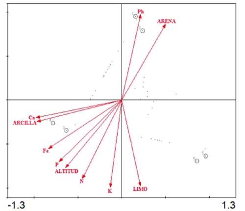
Canonical correspondence analysis
In relation to ACC, the characteristic roots for the first two management axes (Table 5) suggest that the composition of species among plant associations is related to environmental factors of the first two axes of variation; in other words, the analysis is satisfactory, since with the data corresponding to the first two axes of variation, the observed distribution can be explained and, possibly, the physicochemical characteristics are sufficient to explain (Granados et al., 2013).
Table 5 Analysis of canonical correspondence with the values of the characteristic roots, correlation species-environmental factors and percentage of variance explained by the data of species and species-environment relationships, for the management axes.
Axles |
1 |
2 |
3 |
4 |
Characteristic roots |
0.403 |
0.32 |
- |
- |
Species-environmental factors correlation |
1 |
1 |
- |
- |
Cumulative variance (%) of the species |
55.8 |
100 |
- |
- |
Species-environment relations |
55.8 |
100 |
- |
- |
That soil porosity plays a key role in the distribution of vegetation, it was also observed along with altitude, slope and orientation, as the most relevant in its management in the SC. The classification of communities obtained in the AC is confirmed with the ACC diagram (Figure 5), since the associations of the diagrams (Figures 2 and 3) agree on their order.
Conclusions
The use of multivariate analysis techniques contributed to the management of three plant communities, based on 78 species distributed in the studied environmental gradient. Of the variables considered, pH, K, Ca, Fe and altitude were the physical factors that explain to a greater extent the distribution observed in the western sierras and plains of the municipality of Catorce, these indirect factors are related to direct factors, such as humidity and temperature, which determine the availability of water for the plants.
These sites show a high degree of medicinal species (the main detected use), endemic, as well as species at risk, offering information for the understanding of this ecological system that provides the environmental service of in situ conservation of domesticated or wild endemic gene pools and that safeguards a great biocultural heritage under the status of ‘Sacred Natural Site’.
Literatura citada
Braak, T. 1998. CANOCO Reference manual and user’s guide to Canoco for Windows: software for canonical community ordination (version 4). Centere for Biometry. USA. 351 p. [ Links ]
Brush, G. S.; Lenk, C. and Smith, J. 1980. The natural forests of Maryland: an explanation of the vegetation map of Maryland. Ecological Monographs. 50(1):77-92. [ Links ]
CONANP. 2012. Comisión Nacional de Áreas Naturales Protegidas. Estudio previo justificativo para el establecimiento del área natural protegida de competencia de la federación con la categoría de Reserva de la Biosfera ‘Wirikuta’, en el estado de San Luis Potosí. SEMARNAT. México, DF. 32-33, 34-35, 48-49 pp. [ Links ]
Cornelius, J. M.; Kemp; P. R.; Ludwig, J. A. y Cunningham, G. L. 1991. The distribution of vascular plant species and guilds in space and time along a desert gradient. J. Veg. Sci. 2(1):59-72. [ Links ]
De la Cruz, G. A. 1991. Sistema para el análisis de comunidades (ANACOM) Versión 3 (Software). Centro de Investigación y Estudios Avanzados-IPN-Unidad Mérida. Yucatán. [ Links ]
Gonzáles, A. 2003. Clasificación y ordenación de la vegetación del norte de la Sierra Nevada, a lo largo de un gradiente altitudinal. Anales del instituto de Biología. Serie Botánica. 74(1):47-71. [ Links ]
González-Costilla, O. 2007. Flora vascular de la Sierra de Catorce y territorios adyacentes, San Luis Potosí, México. Acta Botánica Mexicana. 78:1-38. [ Links ]
Granados, S. D. 2012. Ecología de los desiertos del mundo. Universidad Autónoma Chapingo. México. 503 p. [ Links ]
Granados, V. R. L.; Granados, S. D. y Sánchez, G. A. 2013. Clasificación de los bosques de pino piñonero (Pinus cembroides ssp. orizabensis) de la cuenca oriental (Puebla, Tlaxcala y Veracruz). Madera y Bosques. 2(21):23-42. [ Links ]
Hernández, H. 1994. Contribución al conocimiento de las cactáceas mexicanas amenazada. Acta Botánica Mexicana. 26:33-52. [ Links ]
Hernández, H. 2004. Checklist of Chihuahuan Desert Cactaceae. Harvard Papers in Botany. 9(1):51-68. [ Links ]
Herrera-Arreola, G.; Herrera, Y.; Reyes-Reyes, B. G. and Dendooven, L. 2007. Mesquite (Prosopis juliflora (Sw.) DC.), huisache (Acacia farnesiana (L.) Willd.) and catclaw (Mimosa biuncifera Benth.) and their effect on dynamics of carbon and nitrogen in soils of the semi-arid highlands of Durango Mexico. J. Arid Environ. 69(4):583-598. [ Links ]
Hunt, D. 1999. Cactaceae checklist. Royal Botanic Gardens. International Organization of Succulent Plant Study. England. 315 p. [ Links ]
Jiménez, S. C. L. 2011. Las cactáceas mexicanas y los riesgos que enfrentan. Revista Digital Universitaria. 1(12):1-23. [ Links ]
Marroquín, J.; Borja, L. G.; Velázquez, C. R. y de la Cruz, C. J. A. 1964. Estudio ecológico dasonómico de las zonas áridas del norte de México. INIFAP. Texcoco, México. 166 p. [ Links ]
Montaña, C. 1990. A floristic‐structural gradient related to land forms in the southern Chihuahuan Desert. J. Veg. Sci. 1(5):669-674. [ Links ]
Pavón, H. N. P. 2000. Distribution of plant life forms along an altitudinal gradient in the semi‐arid valley of Zapotitlán, Mexico. J. Veg. Sci. 11(1):39-42. [ Links ]
Reyes-Reyes, B. G.; Zamora-Villafranco, E.; Reyes-Reyes, M. L.; Frias-Hernandez, J. T.; Olalde-Portugal, V. and Dendooven, L. 2003. Decomposition of leaves of huisache (Acacia tortuoso) and mesquite (Prosopis spp.) in soil of the central highlands of Mexico. Plant and Soil. 256(2):359-370. [ Links ]
Rocha, R. 2006. Comunidades: Métodos de Estudio. Facultad de Estudios Superiores de Iztacala, Universidad Nacional Autónoma de México (UNAM). México, DF. 256 p. [ Links ]
Rzedowski, J. 1994. Vegetación de México. 1ra . Edición. Limusa. México, DF. 432 p. [ Links ]
Sánchez-González, A. 2007. Ordenación de la vegetación de la Sierra de Catorce, San Luis Potosí, a lo largo de gradientes ambientales. Terra Latinoam. 21(3):311-319. [ Links ]
Schlesinger, W. 1998. Plant-soil interactions in deserts. Biogeochemistry. 1(42):169-187. [ Links ]
SEDUVOP. 2006. Desarrollo urbano, vivienda y obras públicas. Plan Municipal de Desarrollo Urbano de Catorce, SLP. SEDUVOP. México. 395 p. [ Links ]
Villarreal, J. 2017. El elemento endémico de la flora vascular del Desierto Chihuahuense. Acta Botánica Mexicana. 118:65-96. [ Links ]
Received: March 01, 2020; Accepted: May 01, 2020
 Este es un artículo publicado en acceso abierto bajo una licencia
Creative Commons
Este es un artículo publicado en acceso abierto bajo una licencia
Creative Commons
