


Services on Demand
Journal
Article
 text in
  English (pdf)
 Article in xml format
 Article references
 Send this article by e-mail
Indicators
-
 Cited by SciELO
 -
 Access statistics
Related links
-
 Similars in
SciELO
Similars in
SciELO
Share

 Permalink
Revista mexicana de ciencias agrícolas
Print version ISSN 2007-0934
Rev. Mex. Cienc. Agríc vol.7 spe 14 Texcoco Feb./Mar. 2016
Articles
Changes in land use in coastal mangroves of Tabasco
1Colegio de Postgraduados-Campus Veracruz. Carretera Xalapa-Veracruz, km. 88.5, predio Tepetates, Veracruz. isela7827@colpos.mx
2Colegio de Postgraduados Campus Tabasco. Periférico Carlos A. Molina carretera Cárdenas-Huimanguillo, km 3.
3Colegio de Postgraduados- Campus Montecillo. Carretera México-Texcoco km 36.5. Montecillo, Estado de México.
The objective was to evaluate the change of land use in the period 1995 to 2008, identifying and quantifying the changes in location and mangroves areas in four suburbs from the municipality of Cárdenas, Tabasco; by interpreting digital orthophotos scale 1:20 000 (1995) and 1:10 000 (2008). The results indicate that in 1995 the mangrove area was 568.49 ha; for 2008 such surface showed an increase of 148.72 ha replacing part of the hydrophytic vegetation and grass-livestock agroecosystem. Though, the generated maps show that in some places mangrove increased and in others its area was reduced, identifying a loss of 32 ha that were replaced mainly by coconut-pasture-livestock agro-ecosystem. This change in land use is a result to the socio-economic conditions of their respective owners. The results can be encouraging, from the ecological point of view, since the new mangrove strips provide a barrier to prevent soil salinization to enter to areas used for livestock.
Keywords: agro-ecosystem; deforestation; land use change; mangrove
El objetivo del trabajo fue evaluar el cambio de uso de suelo en el periodo 1995 y 2008, identificando y cuantificando los cambios en localización y superficie del manglar, en cuatro ejidos del municipio de Cárdenas, Tabasco; mediante la interpretación de ortofotos digitales en escala 1:20 000 (1995), y 1:10 000 (2008). Los resultados indican que en 1995 la superficie de manglar era de 568.49 ha; para 2008 dicha superficie mostró un incremento de 148.72 ha sustituyendo parte de la vegetación hidrofita y el agroecosistema pasto-ganado. Aunque, los mapas generados revelan que en algunos sitios el manglar incremento su superficie y en otros se redujo, identificando una pérdida de 32 ha que fueron sustituidas por el agroecosistema coco-pasto-ganado principalmente. Este cambio de uso de suelo es una respuesta a las condiciones socio-económicas de sus dueños. Los resultados pueden ser alentadores, desde el punto de vista ecológico, ya que las nuevas franjas de manglar sirven de barrera para evitar que la salinización de suelos se introduzca a superficies de uso ganadero.
Palabras clave: agroecosistema; cambio uso del suelo; deforestación; manglar
Introduction
Mangroves are dynamic ecosystems that provide ecological and economic services to human beings allowing the development of aquatic species in their juvenile stages, wood is harvested for trade and for to build houses, and a source of fuel as firewood or carbon. Jimenez (1999) estimated that in the mangroves of the Pacific Coast near 181 species of birds, 30 species of molluscs, 99 species of crustaceans and 87 fish species develop. It is worth noting that most of these species are exploited for trade and are part of the diet of the communities neighboring the mangroves.
Within the ecological services provided by mangroves is climate regulation, erosion control, carbon sequestration, water regulation, coastal protection and eco-tourism or recreational use (Aburto-Oropeza et al., 2008). Similarly, mangroves are important agents of remediation, by function as natural biofilters in contaminated areas with heavy metals (lead, chromium, and cadmium), especially because these compounds are fixed in root biomass and wood (Foroughbakhch et al., 2004), coupled to its function as filters of waste water, since this ecosystem has the capability of reducing organic matter load of water used in its natural processes, which is similar to the role of a wastewater treatment plant (Sanjurjo and Welsh, 2005).
The ecological and economic service provided by mangroves is reduced due to ongoing human activities that give rise to changes in land use, globally stands out wood, oil and gas industry, expansion of shrimp farms, salt flats, industrial and tourism infrastructure, dam construction, and urban development exploitation (FAO, 2007).
Considering that mangrove ecosystems are vulnerable to sea level rise caused by climate change, changes in land use will block their migration into the continent, and therefore will lose the productivity of the ecosystem (Smith et al., 2001), threatening human safety and creating regional and national economic impacts. It is reported that mangrove deforestation in Kenya not only reduces biodiversity, but there is less government revenue in terms of royalties and tourist rights, increased coastal erosion and eventual reduction of seagrasses and coral reefs (Fondo and Martens, 1998). Also, the change in land use is closely related to deforestation, contributing to the process of global warming (Magaña, 2011) due to the release of carbon dioxide.
In Mexico, the most characteristic species of mangrove are Rhizophora mangle L. (red mangrove), Avicennia germinans L. (black mangrove), Laguncularia racemosa (L.) Gaertn. (White mangrove) and Conocarpus erectus L. (button mangrove), according to NOM-059-SEMARNAT-2010 these four species are under threatened category (Lopez and Ezcurra, 2002; DOF, 2010); also identified two species on the coast of Chiapas Rhizophora harrisonii and Avicennia bicolor (Rico, 1982; Jimenez, 1999). Currently it is estimated that Mexico's mangroves cover an area of 770 057 ha distributed in 17 states with coastal influence (CONABIO, 2009).
In the state of Tabasco at least 50% of its wetlands have been lost, where it is estimated that 19922.9 ha correspond to mangroves (Domínguez-Domínguez et al., 2011; Landgrave and Moreno-Casasola, 2012). The main causes for mangrove loss are due to land use change caused by activities such as oil industry, establishment of agricultural areas and grazing (Gallegos and Botello, 1988). The oil industry has generated negative impacts on mangroves due to contamination of water bodies and soil degradation, caused by the continuous oil spills and toxic waste, altering their physicochemical properties and thereby causing the death of propagules, mangrove seedlings and mangrove trees (Adams, 1999; García-López et al., 2006; Olguín et al., 2007; Jacott et al., 2011).
Also, the construction of roads, irrigation canals and establishment of population centers, have caused deforestation and displacement of mangroves, as in the case of the Biosphere Reserve Pantanos de Centla that from 1990 to 2000 suffered a loss of 1 616 ha of mangroves (Guerra and Ochoa, 2005). In this sense the interruption of surface water flow alters the turnover rate increasing salinity and causing the death of mangrove including Avicennia germinans (López and Ezcurra, 2002).
Added to this there is the competition between the mangrove area and the establishment of pastures for livestock use, causing soil drainage for agricultural and livestock expansion. However, it has been found that in areas where natural drainage has been interrupted, there is a large accumulation of salts, particularly NaCl and therefore an increase in pH of the substrate, provoking poor mangrove development and high mortality rate (Gongora, 2005), coupled with losing their capacity for self-regeneration due to intense trampling from livestock and sometimes feed on seedlings and propagules from black and white mangrove (Ramírez et al., 2010). One of the main reasons for the loss of mangroves is the application of productivist economic policies aimed at obtaining shortterm gains (Calderón et al., 2009); coupled with changing patterns of land use and its coverage are determined by the interaction of economic, social, environmental, political, and technological forces at local to global scales (CCSP-LUIWG, 2003).
Overexploitation of resources and land use change, are the backbone on which environmental management of mangrove ecosystem should focus, since it can be handled at regional or local level (Uribe, 2009); similarly, its conservation and sustainable use should be framed in terms of the level of affectation from the different potential agents of disturbance (Flores et al., 2007).
Although generally have been documented the factors that are contributing to mangrove deforestation Mexico, Márquez et al. (2005) mention that deforestation magnitude varies according to the region; in particular, from the period considered and methods used for its assessment. In this sense, in Tabasco there are few studies at local and regional level that allow to identify the impact of agro-ecosystems have on mangrove area and therefore determine their degree of affectation and trends, so it is necessary to generate information that helps as basis for the development of proposals that contribute to the sustainable management of the ecosystem, in this regard to assess the changes in vegetation cover allow to estimate the degree of transformation of a region (Espejel et al., 2004).
Methodology
Study area
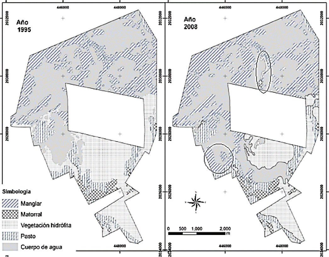
The study area was composed of four suburbs from the municipality of Cárdenas, Tabasco: El Sinaloa located between 18º 18' 50" and 18º 21' 50" north latitude and between 93° 42' 10" and 93º 45' 10" west longitude; El Alacran located between 18º 21' 0'' and 18° 23' 20" north latitude and between 93° 35' 10" and 93º 42' 10" west longitude; El Golpe located between 18º 18' 20" and 18º 20' 40" north latitude and between 93° 28' 50" and 93º 31' 50" west longitude; and Las Coloradas is located between 18º 18' 30" and 18º 20' 10" north latitude and between 93° 32' 20" and 93º 34' 40" west longitude, with a total area of 2 877.04 ha, distributed over the Tabasco coast around the Laguna Machona (Figure 1), which connects to the Gulf of Mexico through an artificial estuary known as Boca de Panteones.
The study area is part of the coastal wetlands of Tabasco, where the dominant vegetation is associated mangrove to estuarine conditions (Barba et al., 2006); the species are Avicennia germinans (black mangrove), Rhizophora mangle (red mangrove), and Laguncularia racemosa (white mangrove); which grow on Histosols and Solonchaks soils (Domínguez-Domínguez et al., 2011). The main economic activities in the area in order of importance are: fishing, livestock, and to a lesser extent agricultural activities.
Analysis and interpretation of digital orthophotos
Coverage and land use changes were analyzed from the interpretation of digital orthophotos scale 1: 20 000 (1995), and 1: 10 000 (2008). The generation and manipulation of spatial information was performed using ArcGisTM Software version 9.3/2008. The coordinates provided by the National Agrarian Registry of the State were used in the construction of the ejido polygons. The interpretation was performed on screen visually and with support of fieldwork. Land use and vegetation types were classified according to that described by Palma et al. (2011); coconut, coco-grass-cattle, body of water, mangrove, grass-cattle, bare soil, hydrophilic vegetation, halophyte grass, tall grass and bushes. This way it was possible to generate preliminary maps at scale of 1: 10 000, for each polygon and know the perimeter, area and type of land use. To quantify surface by soil use class, the Excel 2007 program was used.
Field verification and adjustment of legend
Field verification consisted of periodic visits to the study area in order to check the reliability of the preliminary interpretation of orthophotos. During these tours the types of land use through direct field observations and discussions with the inhabitants of the suburbs were identified. The coordinates were taken with a GPS Garmin model Etrex HTH, which were used for adjustments and corrections.
Results and discussion
Three types of agro-ecosystems neighboring the mangroves were identified: coconut, coco-grass-livestock and pasture-cattle, whose area showed variability in the period evaluated. Table 1 shows that in 1995 the area occupied by the mangroves was 568.49 ha and in 2008 showed an increase of 148.72 ha, replacing part of the hydrophilic vegetation that in 1995 occupied 543.48 ha and in 2008 fell to 355.10 ha. Also, the grass-cattle agro-ecosystem in 1995 occupied an area of 487.07 ha, and for 2008 lost 21.19 ha which were replaced by mangrove. Similarly, in 1995 there were 226 hectares of coconut agro-ecosystem which decreased in 2008 to 36.37 ha, this is due to 189.73 ha were associated with coco-grass-livestock agro-ecosystem and in some cases was invaded by mangrove, mainly in the ejidos El Sinaloa and El Scorpion, which is consistent with that reported by Palma et al. (2007), who mentioned that in the coastal area the land use is based on the cultivation of coconut, alone or associated with grass and mangroves.
Table 1 Area occupied by type of land use in 1995 and 2008.

Cn= camino; Cc= Coco; Cpg= coco-pasto-ganado; Ca= cuerpo de agua; Mg= manglar; Pg= pasto ganado; Sd= suelo desnudo; Vh= vegetación hidrófita; Ph= pasto halófito; Ah= acahual; Mr= matorral; Au= área urbana. Fuente: elaboración propia basada en ortofotos de 1995 y 2008 proporcionadas por INEGI.
In the dynamics of area occupied by mangroves from 1995 to 2008 shows that the ejido El Golpe had the largest increase with 107.28 ha, and to a lesser extent the ejidos Las Coloradas, El Alacran and Sinaloa with 31.2, 7.49 and 2.75 ha respectively. A similar scenario was reported by Sol et al., (2009), assessing the land use change in the UMAFORCosta during the period 2000-2007, identifying an increase of 97 ha of mangrove.
It is possible that the increase in mangrove area is due to tides influence so soil becomes a suitable substrate because of salt water intrusion, excluding species that lack the necessary adaptations to tolerate such environments Sánchez et al. (1998); such is the case of 188.38 ha of hydrophilic vegetation and 21.19 ha of pasture-cattle agro-ecosystem that were displaced by mangrove in the study area. In this regard it is important to say that the area has undergone a salinization process since 1975, derived from the artificial estuary called Boca de Cemeterios, inter-lagoon canals, lagoons dredging and estuaries and channeling access to oil fields (Zavala, 1988). In a survey made landowners it was confirmed that soil surfaces were previously devoted to livestock and now are invaded by mangrove vegetation. According to Yáñez-Arancibia et al. (2010), mangroves have an accommodation capacity to contend more successfully than other natural systems to climate change, so it is expected that in the study area such process is already present.
The estimated figures indicate that mangrove area has increased; however, when comparing the generated maps from 1995 and 2008 it was proven that mangrove has colonized new areas, but in others has been lost, the black circles in Figure 1 show mangrove areas that disappeared in 2008, and others increased. It is estimated a total loss of 32.9 ha being the ejido El Golpe which showed the largest deforested area with 22.6 ha, the ejidos El Alacran and El Sinaloa lost 7.9 ha together. In 2008, the mangrove area lost in the ejido El Golpe and Las Coloradas was replaced by bush, sun flower or tall grass and hydrophyte vegetation, and in the case of ejidos El Alacran and El Sinaloa the replacement was given by human action creating the cocograss-livestock agro-ecosystem.
It is worth noting that the causes why the ejido El Golpe has the largest loss could be the result of timber harvesting that was authorized by SEMARNAT in 2002, the annual harvest volume according to the management plan was 30 000 m3 to exercise in 10 years (2002-2011), considering three species: 8 250 m3 of Rhizophora mangle, 12 000 m3 of Laguncularia racemosa, and 9 760 m3 of Avicennia germinans, with minimum usable diameter of 10 cm for any species (official authorization SGPA/ TAB / 02.-1383 dated August 20, 2002), in 2008 had already exercised 22 400 m3.
However, Flores et al. (2007) considered that the sustainable use of mangrove forest requires of silvicultural techniques with knowledge of load capacity and reforestation. However, in a study by Sol et al. (2009) identified that despite the plans approved for forest management, in the area timber harvesting has not been so regulated as there is no rotation of plots and have been drawn struts of 5 cm in diameter, which limited natural regeneration and favors the development of other type of vegetation. Also, the lack of jobs causes overexploitation of the resource, so it is expected that this exploitation pattern is repeated throughout the areas where population pressure is high and scarce economic resources (López and Ezcurra, 2002). However, such activities are protected by the Law of Sustainable Rural Development that promotes sustainable use of productive natural resources, that allow to increase and diversify sources of employment and income (1st title, article 7, paragraph V), thought does not define clearly what is a sustainable use.
Regarding the mangrove area that was lost due to the establishment of coco-pasture-cattle agro-ecosystem, it is necessary to consider that the market is a determining factor in the decision of land use that farmers do (Márquez et al., 2005). However, it is estimated that the economic benefits generated by the coco-pasture-livestock agro-ecosystems amounts $15 222 86 ha-1 year-1 (US $1 177.48), which is dimensionally minor compared to the benefits provided by a hectare of mangrove, red mangrove maintains a fish productivity of about $37 000 ha-1 year-1, timber harvesting generates profits of US $ 706 ha-1 year-1, the value of wood as a fuel source is estimated at US $11.57 m3 and overall has been estimated that ecosystem services are worth 1 600 million dollars a year (AFE-COHDEFOR/OIMT, 2001; Montiel Aguirre et al., 2006; Stolk et al., 2006; Aburto- Oropeza et al., 2008).
Added to this transformation of mangrove area for the establishment of agro-ecosystems, it is partly a result of land distribution, since assigning flooded soils coupled with the conditions of marginalization led to filling and draining of the same as an alternative to generate goods for consumption and marketing, in this regard article 62 of the Land Law establishes that after land allocation, the farmers will benefit from the use and enjoyment of the same. It is important to consider that the loss in mangrove area causes fragmentation of the ecosystem, and thus places them in a vulnerable status the flora and fauna that depend on this ecosystem including humans.
Conclusions
The coco-grass-cattle agro-ecosystem influences land use change, because these are commercially valuable species that generate economic income to communities with high marginalization; however, it is possible that through a proper use of the many resources offered by the mangrove it can be obtained greater economic benefits without compromising conservation.
The economic benefits of coconut-pasture agro-ecosystem are minimal compared to those provided by the mangrove ecosystem.
The increase in mangrove area found, is the result of human disturbance that favored an environment for its colonization, impacting negatively on cattle-pasture agro-ecosystem.
The results can be encouraging, from the ecological point of view, since the new mangrove strips provide a barrier to prevent soil salinization into areas used for livestock; However, from an economic point of view it is detrimental for farmers who had to leave their land to seek other sources of income.
Literatura citada
Aburto-Oropeza, O.; Ezcurra, E.; Danemann, G.; Valdez, V.; Murray, J. and Sala, E. 2008. Mangroves in the Gulf of California increase fishery yields. PNAS, National Academy of Sciences of de USA. 105(30):10456-10459. [ Links ]
Adams, S. R. H. 1999. Recuperación con mangle blanco (Laguncularia racemosa) de áreas impactadas por hidrocarburos y su manejo como agrosilvo-ecosistema en la zona costera de Huimanguillo y Cárdenas, Tabasco. Universidad Juárez Autónoma de Tabasco. Informe final SNIB-CONABIO proyecto No. M076. México D. F. 214 p. [ Links ]
AFE-COHDEFOR/OIMT. 2001. Valoración económica de los manglares del golfo de Fonseca, Honduras. Choluteca, Honduras. 136 p. [ Links ]
Barba, M. E.; Rangel, M. J. y Ramos, R. R. 2006. Clasificación de los humedales de Tabasco mediante sistemas de información geográfica. Universidad y Ciencia. Universidad Juárez Autónoma de Tabasco, Villahermosa, México. 22(002):101-110. [ Links ]
Calderón, C.; Aburto O. y Ezcurra, E. 2009. El valor de los manglares. CONABIO. Biodiversitas. 82.1-6. [ Links ]
CCSP-LUIWG: climate change science program-land use interagency working group. 2003. A land use and land cover change Science Strategy. Summary of a Workshop held at the Smithsonian Institution. 20 p. [ Links ]
Comisión Nacional de la Biodiversidad (CONABIO). 2009. Manglares de México: extensión y distribución. Diario Oficial de la Federación. 2010. Norma Oficial Mexicana 059-2010. México, D. F.100 p. [ Links ]
Domínguez-Domínguez, M.; Zavala-Cruz, J. y Martínez-Zurimendi, P. 2011. Manejo forestal sustentable de los manglares de Tabasco. Secretaría de Recursos Naturales y Protección Ambiental. Colegio de Postgraduados. Villahermosa, Tabasco. México. 137 p. [ Links ]
Espejel, I. C.; León, G. J.; Fermán, L.; Bocco, F.; Rosete, B.; Graizbord, A.; Castellanos, O. A. y Rodríguez, G. 2004. Planeación del uso del suelo en la región costera del Golfo de California y Pacífico Norte de México. In: Arriaga, R. (Eds.) El manejo costero en México. EPOMEX, SEMARNAT, CETyS, Universidad de Quintana Roo. 321-340 p. [ Links ]
Food and Agriculture Organization of the United Nations (FAO). 2007. The world’s mangroves 1980-2005. Roma. 89 p. [ Links ]
Flores, V. F. J.; Agraz, H. C. y Benítez, P. D. 2007. Ecosistemas acuáticos costeros: importancia, retos y prioridades para su conservación. In: Sánchez, O.; Herzig, M.; Peters, E.; Márquez, R. y Zambrano, L. Perspectivas sobre conservación de ecosistemas acuáticos en México. 1ra. Edición. Instituto Nacional de Ecología. México. 294 p. [ Links ]
Fondo, E. N. and Martens, E. E. 1998. Effects of mangrove deforestation on macrofaunal densities, Gazi Bay, Kenya. Mangroves and salt marshes. 2(2):75-83. [ Links ]
Foroughbakhch, P. R.; Cespedes, C. A. E.; Alvarado, V. M. A.; Núñez, G. A. y Badii, M. H. 2004. Aspectos ecológicos de los manglares y su potencial como fitorremediadores en el Golfo de México. Ciencia UANL. 7(2):203-208. [ Links ]
Gallegos, M. y Botello, A. V. 1988. Petróleo y manglar. Proyecto general: evaluación de los impactos ambientales y sociales de la industria petrolera en el Sureste y Golfo de México. Centro de Ecodesarrollo. Primera Edición. 103 p. [ Links ]
García-López, E.; Zavala-Cruz, J. y Palma-López, D. J. 2006. Caracterización de las comunidades vegetales en un área afectada por derrames de hidrocarburos. Terra Latinoam. 34:17-26. [ Links ]
Góngora, R. F. 2005. Uso del número de árboles por hectárea en el manglar para predecir los sitios de oviposición de los mosquitos costeros. Revista Chapingo. Serie ciencias forestales y del ambiente. 11(001):19-23. [ Links ]
Guerra, M. V. y Ochoa, G. S. 2005. Evaluación espacio-temporal de la vegetación y uso del suelo en la Reserva de la Biosfera Pantanos de Centla, Tabasco (1990-2000). Investigaciones Geográficas, Boletín del Instituto de Geografía, UNAM. México. 59:7-25. [ Links ]
Jacott, M.; Arias, J. M.; Guzmán, H. I. y Franco, A. 2011. Impactos de la actividad petrolera en la salud humana y el ambiente. Conservation, Food and Health Foundation. Fronteras comúnes. Asociación Ecológica Santo Tomas. 36 p. [ Links ]
Jiménez, J. A. 1999. Ambiente, distribución y características estructurales en los manglares del Pacífico de Centro América: contrastes climáticos. In: Yáñez-Arancibia, A. y Lara-Domínguez, A. L. (Eds.). Ecosistemas de manglar en América tropical. Instituto de Ecología A. C. México, UICN/ORMA, Costa Rica, NOAA/ NMFS Silver Spring MD USA. 380 p. [ Links ]
Landgrave, R. y Moreno-Casasola, P. 2012. Evaluación cuantitativa de la pérdida de humedales en México. Investigación ambiental. 4:19-35. [ Links ]
López, P. J. y Ezcurra, E. 2002. Los manglares de México: una revisión. Maderas y bosques. Instituto de Ecología A. C. Xalapa, México. 8(1):27-51. [ Links ]
Magaña, R. V. O. 2011. Cambio climático: el reto del siglo. Investigación Ambiental. México. 3(1):63-67. [ Links ]
Márquez, I.; De Jong, E.; Ochoa, G. y Hernández, M. 2005. Estrategias productivas campesinas: un análisis de los factores condicionantes del uso del uso del suelo en el oriente de Tabasco, México. Universidad y Ciencia. 21(42):56-72. [ Links ]
Montiel-Aguirre, G.; Krishnamurthy, L.; Vásquez-Alarcón, A. y UribeGómez, M. 2006. Opciones agroforestales para productores de palma de coco en el estado de Michoacán, México. Terra Latinoamericana. 24(4):557-564. [ Links ]
Olguín, E. J.; Hernández, M. E. y Sánchez-Galván, G. 2007. Contaminación de manglares por hidrocarburos y estrategias de biorremediación, fitorremediación y restauración. Rev. Int. Cont. Amb. 23:139-154. [ Links ]
Palma-López, D. J.; Vázquez, N. C. J.; Mata, Z. E. E.; López, C. A.; Morales, G. M. A.; Chable, P. R.; Contreras, H. J. y Palma-Cancino, D. Y. 2011. Zonificación de ecosistemas y agroecosistemas susceptibles de recibir pagos por servicios ambientales en la Chontalpa, Tabasco. Colegio de Postgraduados Campus Tabasco, Secretaría de Recursos Naturales y Protección Ambiental. Villahermosa, Tabasco, México. 139 p. [ Links ]
Palma-López, D. J.; Cisneros, D. J.; Moreno, E. C. y Rincón- Ramírez, J. A. 2007. Suelos de Tabasco: su uso y manejo sustentable. Colegio de Postgraduados-ISPROTAB-FUPROTAB. Villahermosa, Tabasco, México. 197 p. [ Links ]
Ramírez, S. A. F.; Trujillo, S. O.; Zentmyer, R. E. H.; Martínez, R. B.; Sheseña, H. I. M. y Rivas, A. J. 2010. Identificación y tipificación de áreas potenciales para la restauración de manglares: el caso de los humedales de la cuenca del río Papaloapan Veracruz México. Pro-natura A. C. Coordinación de proyectos Eco-forestales. 64:12-14. [ Links ]
Rico, G. V. 1982. Rhizophora harrisonii (Rhizophoraceae), un nuevo registro de las costas de México. Boletín de la Sociedad Botánica de México. 41:63-165. [ Links ]
Sánchez, P. H.; Ulloa, D. G. A. y Ricardo, A. L. 1998. Conservación y uso sostenible de los manglares del Caribe Colombiano. Ministerio del Medio Ambiente. Asociación Colombiana de Reforestadores ACOFORE. Organización Internacional de Maderas Tropicales OIMT. Santa Fé de Bogotá Colombia. 224 p. [ Links ]
Sanjurjo, R. E. y Welsh, C. S. 2005. Una descripción del valor de los bienes y servicios ambientales prestados por los manglares. Gaceta ecológica. Instituto Nacional de Ecología. México. 074:55-68. [ Links ]
Smith, J. H. and Schellinhuber, M. M. 2001. Chapter 19. Vulnerability to climate change and reasons for concern: a synthesis. In: McCarthy, J.; Canziani, O. N.; Leary, D.; Dokken, K.; White, O. (Eds.). Climate Change 2001: impacts, adaptation, and vulnerability. Published for the Intergovernmental Panel on Climate Change. Cambridge University Press, Cambridge, United Kingdom, and New York, NY, USA. 942 p. [ Links ]
Sol, S. A.; Zamorano, C. L. F.; Almeida, H. Y.; Hernández, M. G. I. y Shirma, T. E. D. 2009. Estudio regional forestal. Unidad de manejo forestal costa de Tabasco. México. CONAFORECODET A. C. Documento Técnico. 400 p. [ Links ]
Stolk, M. E.; Verweij, P. A.; Stuip, M.; Baker, C. J. y Osterberg, W. O. 2006. Valoración socioeconómica de los humedales en América Latina y el Caribe. Wetlands International. Los Países Bajos. 36 p. [ Links ]
Uribe, P. J. y Urrego, G. L. E. 2009. Gestión ambiental de los ecosistemas de manglar. Aproximación al caso Colombiano. Gestión y Ambiente. 12(2):57-71. [ Links ]
Yáñez-Arancibia, A.; Day, J. W.; Jabob, J. S.; Ibañez, M. C.; Martínez, A. A.; Miranda, A. A.; Tejeda-Martínez, A.; Welsh-Rodríguez, C. M. y Carranza-Edwards, A. 2010. La zona costera en crisis en el Golfo de México, el Caribe y el Mediterraneo. In: Yañez-Arancibia, A. (Ed.). Impactos del cambio climático sobre la zona Costera. Instituto de Ecología, A. C. (INECOL). Texas Sea Grant Progam, Instituto Nacional de Ecología (INESEMARNAT), México. 430 p. [ Links ]
Zavala, C. J. 1988. Regionalización natural de la zona petrolera de Tabasco. INIREB-División Regional Tabasco. Primera Edición. Villahermosa, Tabasco. 182 p. [ Links ]
Received: October 2015; Accepted: March 2016
 Este es un artículo publicado en acceso abierto bajo una licencia Creative Commons
