


Services on Demand
Journal
Article
 text in
  English (pdf)
 Article in xml format
 Article references
 Send this article by e-mail
Indicators
-
 Cited by SciELO
 -
 Access statistics
Related links
-
 Similars in
SciELO
Similars in
SciELO
Share

 Permalink
Revista mexicana de ciencias agrícolas
Print version ISSN 2007-0934
Rev. Mex. Cienc. Agríc vol.7 spe 13 Texcoco Jan./Feb. 2016
Articles
Vulnerability and risk model of rainfed maize production in Nayarit, Mexico
1 Universidad Autónoma de Nayarit. Ciudad de la Cultura Amado Nervo, C. P. 63190. Tepic, Nayarit. (iranbojorquez@hotmail.com; smlmarcel@hotmail.com).
2 Instituto Nacional de Investigaciones Forestales, Agrícolas y Pecuarias- Campo Experimental Santiago Ixcuintla Nayarit, México C. P. 63300. (alvarez.arturo@inifap.gob.mx; vidal.victorantonio@inifap.gob.mx).
3 Universidad Nacional Autónoma de México-Instituto de Geografía, Ciudad Universitaria, México, D. F. (victormr@unam.mx).
In recent years it has increased the impact of weather phenomena in Mexico. This has triggered the need for a better understanding of the vulnerability and risk to such events, particularly in the agricultural sector. In Nayarit it has been documented in time series, the impacts to rainfed maize production (municipal average yields), but has not been quantified the degree of vulnerability and the risk level of this economic activity. The aim of this study was to assess the vulnerability and risk of the maize producing area under rainfed in the state of Nayarit, Mexico. The "Methodological Guide for the Assessment of Vulnerability to Climate Change" was used in three stages: 1) know who, what and why the maize-producing area is vulnerable; 2) it was modeled through indicators the dynamics from the vulnerable object; and 3) the vulnerability and risk model was validated. With this, the summer precipitation and the danger factor in three levels of intensity with their respective impact on yield in terms of probability were identified. Also through a selection of vulnerability indicators for three factors: physical, economic and social, was possible to generate through a multiple linear regression model the corresponding equation that allowed explaining the dynamics of maize grain yield under rainfed. By feeding the model with data from the time series 1980-2012, it was generated and validated a risk model, which by selecting year 2010, allowed to represent and identify the vulnerability distribution of the municipality to rainfall as risk factor under study.
Keywords: climate change; climate variability; indicators
En los últimos años se ha incrementado la recurrencia de los impactos de fenómenos meteorológicos en México. Esto ha detonado la exigencia de un mejor entendimiento de la vulnerabilidad y el riesgo ante eventos de este tipo, particularmente en el sector agropecuario. En Nayarit se tiene documentada en serie de tiempo, los impactos a la producción de maíz de temporal (rendimientos promedios municipales), sin embargo no se ha cuantificado el grado de vulnerabilidad ni el nivel de riesgo de esta actividad económica. El objetivo del presente trabajo fue evaluar el grado de vulnerabilidad y el riesgo de la zona productora de maíz de temporal en el estado de Nayarit, México. Se utilizó la “Guía Metodológica para la Evaluación de la Vulnerabilidad ante Cambio Climático”, en tres etapas: 1) conocer el quien, a qué y por qué la zona productora de maíz es vulnerable; 2) se modeló mediante indicadores la dinámica del objeto vulnerable; y 3) se validó el modelo de vulnerabilidad y riesgo. Con lo anterior, se identificó a la precipitación de verano como el factor de peligro, en tres niveles de intensidad con su respectivo impacto en el rendimiento en términos de probabilidad Asimismo, mediante una selección de indicadores de vulnerabilidad para tres tipos de factores: físicos, económicos y sociales, fue posible generar a través de un modelo de regresión lineal múltiple la correspondiente ecuación que permitió explicar la dinámica del rendimiento de grano del maíz de temporal. Al alimentar este modelo con datos de la serie de tiempo 1980-2012, se generó y validó un modelo de riesgo, el cual al selecciona el año 2010, permitió representar e identificar la distribución de la vulnerabilidad municipal para la precipitación pluvial como el factor de riesgo en estudio.
Palabras clave: cambio climático; indicadores; variabilidad climática
Introduction
Man has witnessed great technological advances, environmental changes and a gradual increase in the level of vulnerability to natural disasters in the last century. The use of information and technology can contribute to decision-making under a climate smart scheme to decrease the impact of threats, i.e., a decrease of vulnerability. For the Intergovernmental Panel on Climate Change (IPCC, 2007) vulnerability is the susceptibility degree and inability of a system to counter climate adversity, including climate variability and extreme events.
Latin America and the Caribbean is vulnerable to meteorological phenomenon ́s and climate events such as hurricanes, droughts and El Niño, which directly affects agricultural production in the region (IDB, 2012). In rainfed areas with marginal production systems, yields will be committed to annual changes in precipitation, resulting in years with contrasting yields (Vallejo-Nieto et al., 2011).
Ponvert-Delisles et al. (2007) points nature as the provider of the misfortunes that afflict society; however, no disasters or losses in productive activities such as agriculture are nature ́s responsibility, just as the authors recommend a scheme where prevention through a multifactorial risk management model allows to reduce the vulnerability associated with risk and not to "natural disaster".
Agreeing that not only environment is responsible for seasonal fluctuations in yield, it has also been found other agents such as market or social phenomena (immigration, economic crisis, etc.) (González-Acuña et al., 2002). In this regard González-Rojas et al. (2011), using an econometric model, concluded that international corn market has a strong influence over national, conditioning the price fluctuation and thereby exacerbates vulnerability.
Another important aspect is the social structure that surrounds the agricultural sector, which has particular socio- demographic characteristics. This component and climate are those that give the corn product system the rainfed and spatial dynamism that characterizes it, for it has been proposed by various authors (Zamudio-Sánchez et al., 2008; Fawaz-Yissi and Vallejos-Cartes, 2011), the use of indicators to measure the economic and community development in a quantitative and qualitative manner.
Given this multifactorial scenario Magaña (2013), proposes a simple model where the best indicator is selected for three factors: economic, social and physical (the latter related to production activities).
There are several studies reporting regional vulnerability maps for rainfed crops through vulnerability and risk models using crop yield data and socioeconomic data (Antwi-Agyei et al., 2012; Jayanthi et al., 2013; Malcomb et al., 2014; Krishnamurthy et al., 2014).
The case study, a rainfed maize producing region lacks irrigation infrastructure, so there is a dependence of a "good weather" (adequate quantity and distribution of rainfall) to obtain commercially competitive yields. So, the aim of this study was to develop a model of vulnerability and irrigation, focused to the rainfed maize production region in the state of Nayarit, Mexico, using the approach proposed by Magaña (2013). It is expected that the results will help to a better understanding of the vulnerability of the Nayarit agricultural sector and as reference for decision-making in the design of public policies for risk management.
Materials and methods
This paper used as main reference the "Methodological Guide for the Assessment of Vulnerability to Climate Change" (Magaña, 2013), which is based on three steps: 1) characterize the object of study and the factors that affect it in order to create a scheme to model its interaction with climate over a period of time; 2) Explain through indicators the dynamics of the object of study; and 3) test the model with risk and impacts of time series according to thresholds defined as alarming.
Database. The database from the National Meteorological Service (SMN) with daily rainfall information from the station 18 005, located in the municipality of Santa Maria del Oro, Nayarit was used. In order to characterize the rainfed maize producing region in the state of Nayarit, daily rainfall data for the months of June through November were accumulated. State yield data were obtained from the State Service for Food and Fisheries Information (SIAP) under the SAGARPA (SIAP, 2014). Data collection was 33 years from 1980-1981 to 2012-2013.
Rainfall seen as risk. Annual precipitation data were organized into tertiles and the incidence of precipitation percentage was calculated and related to yield by a double- entry table.
Identifying vulnerability. An iterative search in different databases was made in order to create a collection of social, economic and physical environment indicators related to the agricultural sector of rainfed maize. The data was organized in Microsoft Excel version 2010 chronologically, always looking for the time series data from 1980-2012. The bases from explored data came from institutions such as INEGI, CONAPO, SAGARPA, SE, SHCP and Banxico through different indicators. The selection criterion was the one with best relationship with the annual average maize yield expressed by the coefficient of determination (r2).
Vulnerability model. For the generation of mathematical model to explain the dynamics of rainfed maize yield in the study area using only three indicators, the Minitab statistical software version 16.2.4 was used through multiple linear regressions. Also the beta coefficients of each indicator in the model were calculated in order to meet the weighted arithmetic mean that each variable contributes to the model.
Validation of vulnerability model. In order to validate the model output, the coefficient of correlation between the observed data (yield from SIAL database) and the predicted by the model were calculated.
Risk model. Risk is the product of the probability of the presence of a threat and vulnerability. The model was validated graphically, exposing the dynamics of vulnerability, danger and risk associated with impacts on rainfed maize production (yield decrease).
Mapping. To test the functionality of the model at space level, 2010 data were entered in the three selected factors. Then the weighted value of each factor was weighted according to the specific weigh in the model. Finally weighted arithmetic means were added, organized from lowest to highest and three classes of vulnerability level (low, medium and high) were created with an amplitude range of each class of 0.09. For mapping the GIS ArcMap version 10 was used, where a thematic map was created, where the three classes per color (red= high vulnerability, medium vulnerability= yellow and green= low vulnerability) are indicated.
Results and discussion
The vulnerability model for rainfed maize production in the state of Nayarit, Mexico consistently explains the dynamics of the annual yields on the time series studied in this paper.
The risk
The accumulated rainfall in the summer production cycle largely explains yields in the rainfed corn area from Nayarit. When precipitation was less than 1050 mm it was classified as "low" and "high" when it increased to 1 120 mm. On the other hand, yields were classified as "low" under 2.6 t ha-1 and "high" greater than 3.3 t ha-1, in both cases the intermediate range between the two classes is considered "medium". When precipitation is classified as "low", 81% of the years the yields were lower 3.3 t ha-1: in contrast when it is classified as "high" 45% of the years reported yields above 3.3 t ha-1. In years when the rainfall varies between 1 050 and 1 120 mm, 70% of years reported yields above 2.6 but lower than 3.3 t ha-1 (Table 1).

The critical threshold to be used in the risk model will be the probability that low yield presents (<2.6 t ha-1) in the range of low precipitation (<1 050 mm) this is 36.4.
Vulnerability
The vulnerability of rainfed agriculture to weather fluctuations has changed and improved over the past two decades, not only in Nayarit, but in much of the country. Therefore, it is required to document the behavior of vulnerability as a key factor when it comes to analyzing the risk of agriculture to variability in rainfall, as suggested by Magaña (2013).
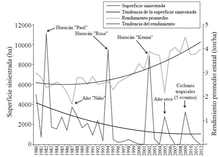
The study area has low technology for agricultural work (INEGI, 2007), soils have low fertility (González-Acuña at al., 2002) or, conversely, those with high fertility have a different land use than rainfed corn, high claims and poor culture for disaster prevention, as crop insurance (INEGI, 2013). The years with highest incidence of disaster area are related with hurricanes or drought (Figure 1). However, the disaster area has decreased since 1980 in 50%. Moreover, yield shows a positive trend going from 2.5 t ha-1 average yield s in 1980 to more than 4 t ha-1 nowadays.
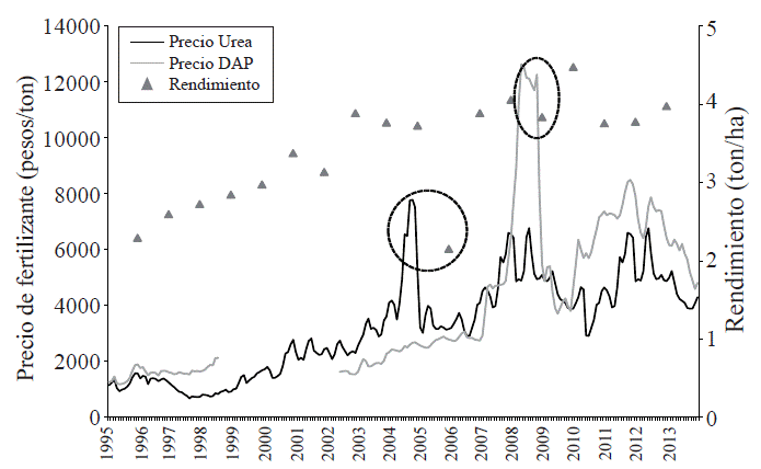
At the same time, the economic factors, for example the exchange rate of peso to dollar, have a significant impact on the activity as dollar governs the purchase price as pointed out by González-Rojas et al. (2011), the price of inputs (fertilizers, insecticides, herbicides, etc.) and seed price. In the dynamics of the activity, measured through rainfed maize yields, a negative impact is noticed when the exchange rate experiences significant changes (Figure 2).

This suggests that producers do not use high cost seeds (and better yield), do not apply full dose of fertilizer or pesticides or herbicides and all in detriment of yield (Figure 3).
Vulnerability indicators
The indicators explored by factor are shown in Table 2, being these selected to characterize the social factor: aging population index of rural areas, which is the ratio between people over 65 year old and under 15 years. For the economic factor: exchange rate, which has as principle to describe the relationship between the Mexican peso against the US dollar (for many practical applications the exchange rate is an indicator of peso devaluation or level of purchase capacity of imported goods as agricultural inputs). Finally for the physical factor was selected: the cation exchange capacity (CEC) of the soil, which is an indicator of soil fertility in terms of the ability of the latter to provide the minerals required by the plant for its growth and development in productive terms.

Vulnerability model
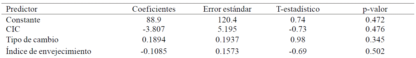
In Table 3 can be seen the statistical model of multiple linear regression. According to the results, the weighted contribution to the beta coefficient equation of each variable was: physical (44.8%), social (38.2%) and economic (17%). The generated regression equation was: Yield= 89 - 3.81 CEC + 0.189 exchange rate - 0.108 aging index.
Validation of vulnerability model
The functionality of the model was corroborated in the time series (1995-2012), defined as observed data the state average maize yield under rainfed and as predicted by the model output. The correlation coefficient between observed and predicted was 0.77; however, the determination coefficient is 0.59 which is acceptable for this type of model given the variation of the weighted arithmetic means of the coefficients (Table 4). The distribution of the residuals from the regression model in the normal probability plot reflected an acceptable fit (Figure 4A); while the goodness average of fit of the model was ± 0.5 (Figure 4B); with both tools, the normality and homoscedasticity error was verified, demonstrating the acceptable standard model to predict maize yield under rainfed. The model "overestimates" in 2005, year in which lower yields were obtained due to severe drought.
Table 4 Annual average yield observed for rainfed maize in Nayarit (t ha-1) and yield predicted by the vulnerability model.

R= 0.77 r2= 0.59

Risk model
Events where the risk index exceeded the level below the critical level (1050 mm of precipitation in the rainfed period) were in 2001, 2005, 2011 and 2012. During these periods yield decreases presented, contrasting with the trend, particularly 2005 and 2001. This coincides with the indicated by Magaña (2013), who states that if the vulnerability model presents a dynamic that conjugated with danger explains a high risk on the negative impacts of the object of study, the indicators can be considered "adequate" (Figure 5).

Vulnerability distribution in Nayarit
The vulnerability index applied at municipal level in the state of Nayarit in 2010 shows how the rainfed maize-producing region is heterogeneous, as they are at low level in Jala and La Yesca (municipalities with low aging index and acceptable level of soil fertility). At medium level are Santa Maria del Oro, San Pedro Lagunillas, Ixtlan del Rio and Amatlán de Cañas and only Ahuacatlán as high level (highest aging index). In the rest of the state dominate the medium level, mainly in coastal municipalities which are characterized by their low surface of rainfed maize (Figure 6).

Conclusions
The risk model allowed to identify the critical threshold of summer precipitation seen as risk (<1 050 mm) in which rainfed maize yields are affected negatively. Similarly, the use of a vulnerability model that was integrated by indicators based on a physical factor (cation exchange capacity of the soil), economic (peso vs dollar) and social (aging index of rural population) allowed to know the vulnerability dispersion at the municipal level. This work helps to a better understanding of the vulnerability and the risk of rainfed corn production in the state of Nayarit and exposes an alternative to the construction of the mathematical model, which contributes to better implementation of the guidelines issued by Magaña 2013.
Literatura citada
Antwi-Agyei, P.; Fraser, E D.; Dougill, A. J.; Stringer, L. C. and Simelton, E. 2012. Mapping the vulnerability of crop production to drought in Ghana using rainfall, yield and socioeconomic data. Applied Geography. 32:324-334. [ Links ]
BID (Banco Interamericano de Desarrollo). 2012. El cambio climático y la producción agrícola. Estados Unidos de América. Notas Técnicas. 36 p. [ Links ]
Fawaz-Yissi, J. y Vallejos-Cartes, R. 2011. Calidad de vida, ocupación, participación y roles de género: un sistema de indicadores sociales de sostenibilidad rural (Chile). Colombia. Cuadernos de desarrollo rural. 67(8):45-68. [ Links ]
González-Acuña, I. J.; Ruiz-Corral, J. A.; Martínez-Parra, R. A.; Byerly- Murphy, K. F.; Mena-Hernández, L. y Osuna-García, J. A. 2002. Determinación del potencial productivo de especies vegetales para el municipio de Santa María del Oro, Nayarit. Instituto Nacional de Investigaciones Forestales Agrícolas y Pecuarias (INIFAP). México. Folleto de investigación Núm. 15. 61 p. [ Links ]
González-Rojas, K.; García-Salazar, J.A.; Matus-Gardea, J.A. y Martínez- Saldaña, T. 2011. Vulnerabilidad del mercado nacional de maíz (Zea mays L.) ante cambios exógenos internacionales. México. Agrociencia. 45(6):733-744. [ Links ]
INEGI (Instituto Nacional de Estadística y Geografía). 2007. Principales cultivos agrícolas de Nayarit: Censo Agropecuario 2007. México. 91 p. [ Links ]
INEGI (Instituto Nacional de Estadística y Geografía). 2013. Anuario Estadístico y Geográfico de Nayarit 2013. México. 429 p. [ Links ]
IPCC (Intergovernmental Panel on Climate Change). 2007. Cambio climático 2007: informe de síntesis. Contribución de los grupos de trabajo I, II y III al cuarto informe de evaluación del grupo intergubernamental de expertos sobre el cambio climático. Ginebra, Suiza. 104 p. [ Links ]
Jayanthi, H.; Husak, G.; Funk, C.; Magadzire, T.; Chavula, A. and Verdin, J. P. 2013. Modeling rain-fed maize vulnerability to droughts using the standardized precipitation index from satellite estimated rainfall- Southern Malawi case study. Int. J. Disaster Risk Reduction. 4:71-81. [ Links ]
Krishnamurthy, P. K.; Lewis, K. and Choularton, R. J. 2014. A methodological framework for rapidly assessing the impacts of climate risk on national-level food security through a vulnerability index. Global Environmental Change 25:121-132. [ Links ]
Magaña-Rueda, V. O. 2013. Guía metodológica para la evaluación de la vulnerabilidad ante cambio climático. México. 61 p. [ Links ]
Malcomb, D. W.; Weaver, E. A. and Krakowka, A. R. 2014. Vulnerability modeling for sub-Saharan Africa: An operationalized approach in Malawi. Applied Geography 48:17-30. [ Links ]
Ponvert-Delisles, R. D.; Lau, A. y Balamaseda, C. 2007. La vulnerabilidad del sector agrícola frente a los desastres. Reflexiones generales. Perú. Zonas Áridas. 11(1):174-194. [ Links ]
SIAP (Servicio de Información Agroalimentaria y Pesquera). http://www.siap.gob.mx/cierre-de-la-produccion-agricola-por-estado. [ Links ]
Vallejo-Nieto, M. I.; Gurri-García, F. D. y Molina-Rosales, D. O. 2011. Agricultura comercial, tradicional y vulnerabilidad en campesinos. México. Política y Cultura. 36:71-98. [ Links ]
Zamudio-Sánchez, F. J.; Corona-Ambriz, A. y López-Becerril, I. D. 2008. Un índice de ruralidad para México. México. Espiral, estudios sobre estado y sociedad. 42(14):179-214. [ Links ]
Received: November 2015; Accepted: February 2016
 Este es un artículo publicado en acceso abierto bajo una licencia Creative Commons
