


Services on Demand
Journal

Article
 text in
  English (pdf)
 Article in xml format
 Article references
 Send this article by e-mail
Indicators
 Cited by SciELO
 Related links
 Similars in
SciELO
Similars in
SciELO Share

 Permalink
Revista mexicana de ciencias agrícolas
Print version ISSN 2007-0934
Rev. Mex. Cienc. Agríc vol.5 spe 8 Texcoco 2014
Investigation notes
Hydrologic connectivity between basins, municipalities and the El Triunfo Biosphere Reserve, Chiapas, Mexico
1Programa Manejo Integral de Cuencas, Campo Experimental Centro de Chiapas, INIFAP.
2Manejo Forestal Sustentable y Servicios Ambientales, Campo Experimental Centro de Chiapas, INIFAP.
3Socioeconomía, Campo Experimental Centro de Chiapas, INIFAP. Carretera Ocozocoautla-Cintalapa, km 3, A. P. Núm. 1. C. P. 29140. Ocozocoautla, Chiapas. Tel. 019686882911. (camas.robertony@inifap.gob.mx; reynoso.roberto@inifap.gob.mx; cadena.pedro@inifap.gob.mx; castro.itzel@inifap.gob.mx).
In 2011 the connectivity between basins, municipalities and the El Triunfo Biosphere Reserve (REBITRI), was studied, in order to guide the design of conservation programs. Overlapping polygons of basin, municipalities and the reserve, the land and water connectivity was analyzed using the contingent valuation methodology, a survey of users' willingness to pay for water services and runoff was estimated by the water balance method in four representative basins. The reserve shares administrative boundaries with 9 municipalities, but under the hydrologic connectivity analysis, extends its influence to 11 municipalities across 14 basins. Water is a strategic environmental service for consumption of 400 000 inhabitants, production and processing of agricultural commodities, hydropower generation, maintenance of biodiversity and as flood risk regulator. Because of its greater volume of potential net water recharge (m3 ha-1 year-1) and location in the mountain range, REBITRI is strategic as a water recharge zone and downstream flood risk regulator. The information generated is useful for creating cooperation and compensation mechanisms between society, sectoral agencies, municipalities and NGO's to boost the competitiveness of the territory with a basin approach.
Keywords: conservation; compensation; environmental water services
En el año 2011 se estudió la conectividad entre cuencas hidrográficas, municipios y la Reserva de la Biósfera El Triunfo (REBITRI), con el propósito de orientar el diseño de programas para su conservación. Sobreponiendo los polígonos de las cuencas, municipios y reserva se analizó la conectividad territorial e hídrica, usando la metodología de valoración contingente se realizó un sondeo sobre la disposición a pagar de los usuarios por el servicio hídrico y se estimó el escurrimiento por medio de método del balance hídrico en cuatro cuencas representativas. La reserva comparte límites administrativos con 9 municipios, pero bajo el análisis de conectividad hídrica amplía su influencia a 11 municipios a través de 14 cuencas hidrográficas. El agua es un servicio ambiental estratégico para consumo de 400 000habitantes, producción y transformación de productos agropecuarios, generación de energía hidroeléctrica, mantenimiento de la biodiversidad y como regulador de los riesgos de inundaciones. Por su mayor volumen de recarga hídrica neta potencial (m3 ha-1 año-1) y ubicación en la cadena montañosa, la REBITRI es estratégica como zona de recarga hídrica y reguladora de riesgos por inundaciones aguas abajo. La información generada es útil para generar mecanismos de cooperación o compensación entre sociedad, dependencias sectoriales, municipios y ONG's para impulsar la competitividad del territorio con un enfoque de cuencas.
Palabras claves: conservación; compensación; servicio ambiental hídrico
On September 13th, 1990, the REBITRI was established in Chiapas, being important for providing a wide range of services to society and ecosystem regulations, which help maintain the overall balance on the planet. It protects cloud forests, tropical pine and oak forests, plus water systems in an area of approximately 120 000 hectares. Provides the habitat with 40% of the birds in Mexico (175 species) and 800 plants species. The reserve has a population of about 14 000 inhabitants distributed in 29 ejidos, 108 privately owned lands, and one communal land (CONANP, 2008). Despite its importance, REBITRI is threatened by: 1) lack of knowledge and inadequate appreciation by society and the three levels of government about their ecosystem services, which are utilized for their welfare without any recognition, and least of all pay for its use; and 2) the lack of studies showing the benefits derived from its conservation. In this context, Karin (2007) points out the need for studies to convince politicians and the general public to invest in favor of conservation.
In order to ensure the REBITRI conservation and social development, the El Triunfo Conservation Fund Inc. (FONCET), was established in 2002, oriented to building long-term financial mechanisms by demonstrating the benefits deriving from the REBITRI conservation. This research was conducted with the aim of supporting with data, land and water connectivity between basins, municipalities and the REBITRI area, to guide the design of cooperation and compensation mechanisms for the sustainable development of the territory.
It was based on the REBITRI polygon located in the Sierra Madre de Chiapas between the coordinates 15° 09 '10 "and 15° 57' 02" north latitude and 92° 34' 04 " and 93° 12' 42" west longitude with an area of 1 191.7 km2. Stage I: a) Basins linked to REBITRI were delimited using the SWAT hydrologic model (Arnold et al, 1991) to identify the runoff network and watershed using the ArcMap 10.1 platform, in which the digital elevation models had been entered by INEGI (2010) 1:50 000; b) From overlapping polygons of basins, REBITRI and municipalities, land and water connectivity analysis was performed. Stage II: a) An inventory of water users was carried out and using the contingent valuation methodology (Whittington et al., 1990) 36 of them were surveyed about their willingness to pay for avoiding a decrease in water quality and supply or an increase in flood damage, b) Information was collected from REBITRI on socio-economic aspects, land use, water use types, flood disaster risk and damage it causes, production infrastructure, municipal development plans and conservation programs. Stage III: In four basins, water volumes (m3 ha-1 year-1) draining and infiltrating were assessed, comparing areas inside and outside the reserve. Water balance methodology proposed by Llerena (2003) for basins with little information available was used. Stage III. Based on the environmental water services provided by REBITRI the implications for the creation of a local water market were analyzed.
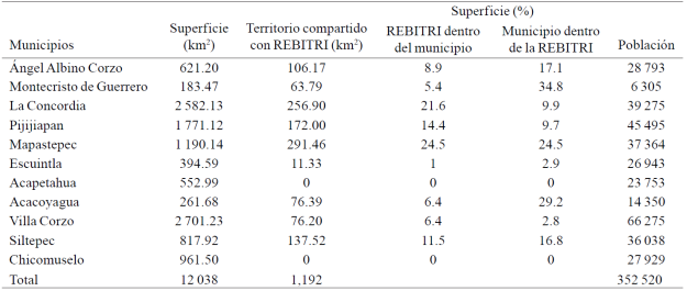
Connectivity between REBITRI and municipalities: Although the reserve shares area with nine municipalities, 72% ofits territory is shared with Mapastepec, La Concordia, Pijijiapan and Siltepec. Other municipalities such as Montecristo de Guerrero, Acacoyagua, Mapastepec, Angel Albino Corzo and Siltepec are highlighted by the proportion oftheir territory located within the reserve (Table 1). These municipalities are key mechanisms to promote cooperation for the reserve conservation.
Connectivity between REBITRI and basins: the reserve shares territory with 14 basins (Figure 1). The Chavarria, El Dorado, Cuxtepeques, Jaltenango, Independencia and Las Delicias rivers basins are tributaries of the Grijalva River, draining into the Gulf of Mexico, with an average annual rainfall between 1 000-2 000 mm and in a height range between 800-2 700 masl. The Pijijiapan, Coapa, Margaritas-Las arenas, Novillero, San Nicolás, Cacaluta, Jalapa and Cintalapa rivers basins drain into the Pacific Ocean, with an average annual rainfall between 2 000-4 000 mm and height range from 0-2700 masl. Given its location on the upper part, REBITRI functions as water recharge area for these basins.
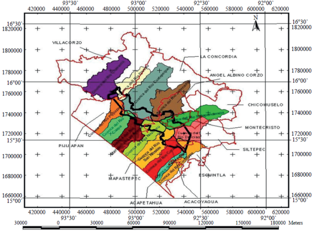
Connectivity between REBITRI, municipalities and basins: this analysis clearly shows that water flows move according to the watersheds and are not confined to municipal boundaries. For example, Acapetahua and Chicomuselo municipalities do not share territory with REBITRI, the first being within the influence area of the Jalapa, Cacaluta and Cintalapa rivers basins and the second within that of Independence and Delicias rivers (Figure 1), they are connected to it through the water flows from the top to the bottom. Figure 2 shows the land and water connectivity map of REBITRI with 14 municipalities and basins.
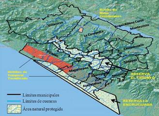
The relationship between the upper and lower part of the basin is expressed in a dynamic ecosystem with important ecological, socioeconomic and governance implications in the 11 municipalities connected with REBITRI. The regulation of this dynamics, being determined by the action of gravity, depends largely on the population ability to rationally use natural resources in the middle and upper parts of the basins, i.e., in the area where REBITRI is located.
Importance of REBITRI in water regulation: water as connectivity source has two roles for society: 1) As a strategic ecosystem service for various uses (water supply for 400,000 people, production and processing of agricultural products, generation of hydroelectric energy and maintenance of biodiversity among others); and 2) As a flood risk regulator and the damage they cause to the economy as a whole, since the 11 municipalities connected with REBITRI are considered vulnerable to hydrometeorological phenomena. REBITRI conservation is a strategic decision, since given its location in the mountain range and privileged cloud forest vegetation, captures plenty of rain becoming the major source of water supply and a key regulator of downstream flood risks on both sides of the Sierra Madre area (Hamilton et al., 1995).
The assessment of infiltration capacity in four basins shows the importance of REBITRI in regulating runoff towards the bottom (Table 2). On average, the REBITRI area provides 26.3% of infiltrated net water volume despite representing only 16% of the total area. This is because the infiltration capacity of one hectare within the reserve is between 2-2.5 times greater than that of one hectare outside. Paradoxically REBITRI is threatened by an increasing deforestation rate, from 1970 to 1993, the percentage of forested areas decreased from 62.2 to 53.6% (March and Flamenco, 1996). Deforestation is altering the infiltration capacity, and consequently, the rivers levels in the dry season, the violence of the post-storm flows, rates of soil erosion and flood disasters (López et al. 2011).

The region lacks a policy of land management considering the hydrologic cycle, its scope and recurrence by contrast, it follows a pattern of nature adaptation to short-term economic interests and uncontrolled population growth. With these limitations in public policy, the society will continue to pay high economic, social, political and environmental costs, such as those paid in 1998 and 2005 for the occurrence of Stan and Mitch hurricanes, and even higher negative impacts are expected in the next years due to climate change, particularly in the agricultural and water sectors (SHCP, 2009).
Potential local water market: 30 water user groups (public and private) were identified, who in the first instance could participate as sponsors in a program of environmental water services payment (PSAH). All these actors have a need or demand for environmental services of water provision or regulation provided by REBITRI. The survey on 36 private users who are obtaining economic benefits from water, noted that 92% of them have an interest in the conservation of REBITRI, and of these, 82% were willing to make voluntary financial contributions, provided that there were guaranteed results and transparency in the management of contributions. This survey although preliminary, shows the potential for creating a local water market, therefore more specific studies on this topic are recommended.
This study from the basin perspective, allows to describe, understand and appreciate the important role of REBITRI as water recharge area and regulatory system for downstream flood risk in both sides of the Sierra Madre de Chiapas. Further, an alternative is proposed to manage REBITRI and its basins, comprehensively including economic development, social welfare, environmental protection, adaptation to climate change effects, as well as the participation of society using these resources, and federal, state and municipal governments, through an integrated and environmentally friendly approach in a common territory.
Literatura citada
Arnold, J. G.; Neitsch, S. L. y Williams, J. R. 1991. Soil and water assessment tool user's manual. Version 99.2. Lackland Research Center, Texas Agricultural Experimental Station. Temple, TX. [ Links ]
CONANP. 2008. Programa de manejo y conservación de la Reserva de la Biósfera El Triunfo. Extracto para revisión del consejo asesor. Tuxtla Gutiérrez, Chiapas, México. 87 p. [ Links ]
Hamilton, L. S.; Juvik, J. O. and Seatena, F. N. 1995. Tropical montane cloud forest. Series Ecological Studies. Vol. 110. New York, Springer Verlag. [ Links ]
Instituto Nacional de Geografía, Estadística e Informática (INEGI). 2010. Datos vectoriales. http://www.inegi.org.mx/sistemas/usuarios/login.aspx?s=geo&sistema=dinf1em. [ Links ]
Karin, M. K. 2007. Valoración de cuencas como una herramienta para la conservación de la biodiversidad. Lecciones aprendidas de proyectos de conservación. The Nature Conservancy. USA. 48 p. [ Links ]
Llerena, C. 2003. Servicios ambientales de las cuencas y producción de agua. Conceptos, valoración, experiencias y sus posibilidades de aplicación en el Perú. In: Foro Regional sobre sistemas de pago por servicios ambientales. Arequipa, Perú. 16 p. [ Links ]
López, B. W.; Magdaleno, G. R.; Jiménez, C. L. A.; Reynoso, S. R. y Salinas, C. E. 2011. Deforestación en la cuenca del río Cuxtepeques, La Coneordia, Chiapas, México. In: Memoria del 2° Congreso Nacional de Manejo de Cuencas Hidrográficas. Tabasco, México. 79-80 pp. [ Links ]
March, M. I. J. y Flamenco, S. A. 1996. Evaluación rápida de la deforestación en las áreas naturales protegidas de Chiapas (1970-1993). The nature conservancy, Ecosur, Usaid. 66 p. En: En: http://200.23.34.25/Art tne.pdf . (consultado mayo, 2011). [ Links ]
Secretaria de Hacienda y Crédito Público (SHCP). 2009. La economía del cambio climático en México: Síntesis. Galindo, L. M. (Coord.). SHCP-SEMARNAT. 67 p. [ Links ]
Whittington, D.; Briscoe, J.; Mu, X. and Barron, W. 1990. Estimates the willingness to pay for water services and developing countries: a case study of the use of contingent valuation surveys in southern Haiti. Economics Development and Chage. 38. [ Links ]
Received: March 2014; Accepted: April 2014
 Este es un artículo publicado en acceso abierto bajo una licencia Creative Commons
