


 text new page (beta)
 English (pdf)
 Article in xml format
 Article references
 Send this article by e-mail
 Cited by SciELO
  Similars in
SciELO
Similars in
SciELO 
 Permalink
INTRODUCTION
Salinization of soils is one of the problems that often disturb agriculture worldwide. It is estimated “that the global annual cost of salt-induced land degradation in irrigated areas could be US$ 27.3 billion, because of lost crop production” (Qadir et al., 2014).
A saline soil is defined as one that contains enough soluble salts to harmfully disturb the growth of agricultural crops. Worldwide, nearly 10% of the total land surface (over one billion ha) contains salt affected soils, no continent is free of such soils and it has been estimated that nearly 10 million ha of arable land are lost by salinization every year (Shahid et al., 2013). In arid and semiarid regions, salinization of soils is a common characteristic, although it can also occur in more temperate environments. It could represent a problem due to its negative impact on crop yields (Thomas and Middleton, 1993).
Montanarella et al. (2016), recently published the World´s Soil Resources Report, with contributions from 200 soil scientists from 60 countries. They appoint that the primary global drivers of soil change are population and economic growth, related to increase in consumption of resources and waste generation. The third primary driver is climate change through its current and anticipated effects on land use and management. For Mexico, the first main threat is erosion, the second is organic carbon change and the third is salinization and sodification.
In Mexico, agricultural production areas that have larger salinity and drainage problems are mainly located in irrigation districts in the north, where arid and semi-arid climatic conditions prevail. Around 34 million ha (17.9% of the country) present chemical soil degradation (SEMARNAT, 2015). Soil salinization directly affects 3.2% of the country, mainly in the states of Chiapas, Nuevo León, Oaxaca, Sonora, Sinaloa, San Luis Potosí, Veracruz and Zacatecas (SEMARNAT, 2009).
Karmakar et al. (2016) reviewed the potential effects of climate change on soil properties, including the rise of soil salinization and alkalization in areas where evaporation increased or rainfall decreased due to climate change. They recommend monitoring of land degradation keeping in view productivity and economic losses in relation to climate change effects. Freshwater resources will be challenged by the trends of climate change that forecast higher temperatures and lower rainfall and potential increase in water demand driven by population. By changing the chemical quality of water, salinization contributes to losses in biodiversity and soil fertility. Soil salinization as a result of long-term irrigation represents a hazard for the environment and local economies. Hence, water quality assessment is of the upmost importance.
Quality of water indicates suitability of the resource for different uses, because each kind of water use needs certain biological, chemical and physical characteristics. Several water quality indices have been proposed, taking into account: nutrients, pollutants, dissolved ions, physicochemical parameters, physical stream conditions and/or ecological characteristics. According to Gholamreza (2015) these indices can be summarized into five groups:
General water quality index methods, which do not take into account the water usage.
Specific water quality index techniques that define water quality for specific usage as irrigation, industrial, drinking and protection of aquatic life.
Design indices; water quality classification is not taken into account. It is a tool to assess the impact of decisions and plan future measures for water management.
Statistical indices; they use statistical models for water quality classifications being the most objective methods.
Biological indices; they define water quality according to the effects of water on aquatic life.
The most widely used water quality indices to evaluate potential salinity risk of soils are Residual Sodium Carbonate (RSC) and Sodium Adsorption Ratio (SAR) (Smith et al., 2015). In view of the limited number and uncertainty of using only two indices, in the present work a novel water quality assessment was applied for the first time by statistically combining eight individual quality indices for irrigation water in zones susceptible to soil salinization. These are: RSC (Eaton, 1950), SAR (Richards, 1954), percentage of sodium (%Na) (Wilcox, 1955), Kelley index (KI; Kelley, 1963), permeability index (PI; Doneen, 1964), soluble sodium percentage (SSP; Todd and Larry, 2005), magnesium adsorption ratio (MAR; Raghunath, 1987) and recently, cation ratio of structural stability (CROSS) (Smith et al., 2015).
These combined-indices approach is tested in the agricultural region of Tierra Nueva, San Luis Potosí, where recent soil salinization processes are evident from salt precipitates composed of natrite (Na2CO3), making some farming zones unsuitable for agriculture and where visual observations by the authors and reports by farmers indicate that crops do not grow as vigorously as they used ca. 4 years ago. Agriculture is the main economic activity in the Tierra Nueva area and hence the assessment of water quality is of great importance to determine the convenience of its use. The assessment of the hydrogeochemical processes occurring in the watershed is of great importance, to advise a sustainable use of water and soil resources.
Study site
The Tierra Nueva study area is located between latitudes N21º43.30' and N21°36.20' and between longitudes W100°31.20' and W100°40.00'. Climate is semi-arid with rains in the summer and annual average temperature of 18.6 °C. Average annual rainfall is 444.6 mm, and annual potential evaporation is 1740.92 mm (DOF, 2015).
Tierra Nueva is located in the Santa María volcanic complex, San Luis Potosí, Mexico. The formation of this volcanic complex began with the emission of andesitic lava flows and rhyolitic pyroclastic deposits, which were covered by a package of lavas with compositions ranging from trachyte to high-silica rhyolite, and occasional intercalation at specific sites of andesite-basalt lavas (Figure 1). The volcanic package was affected by a series of NW-SE normal faults forming a domino arrangement of narrow tectonic pits (Tristán-González, 1987).
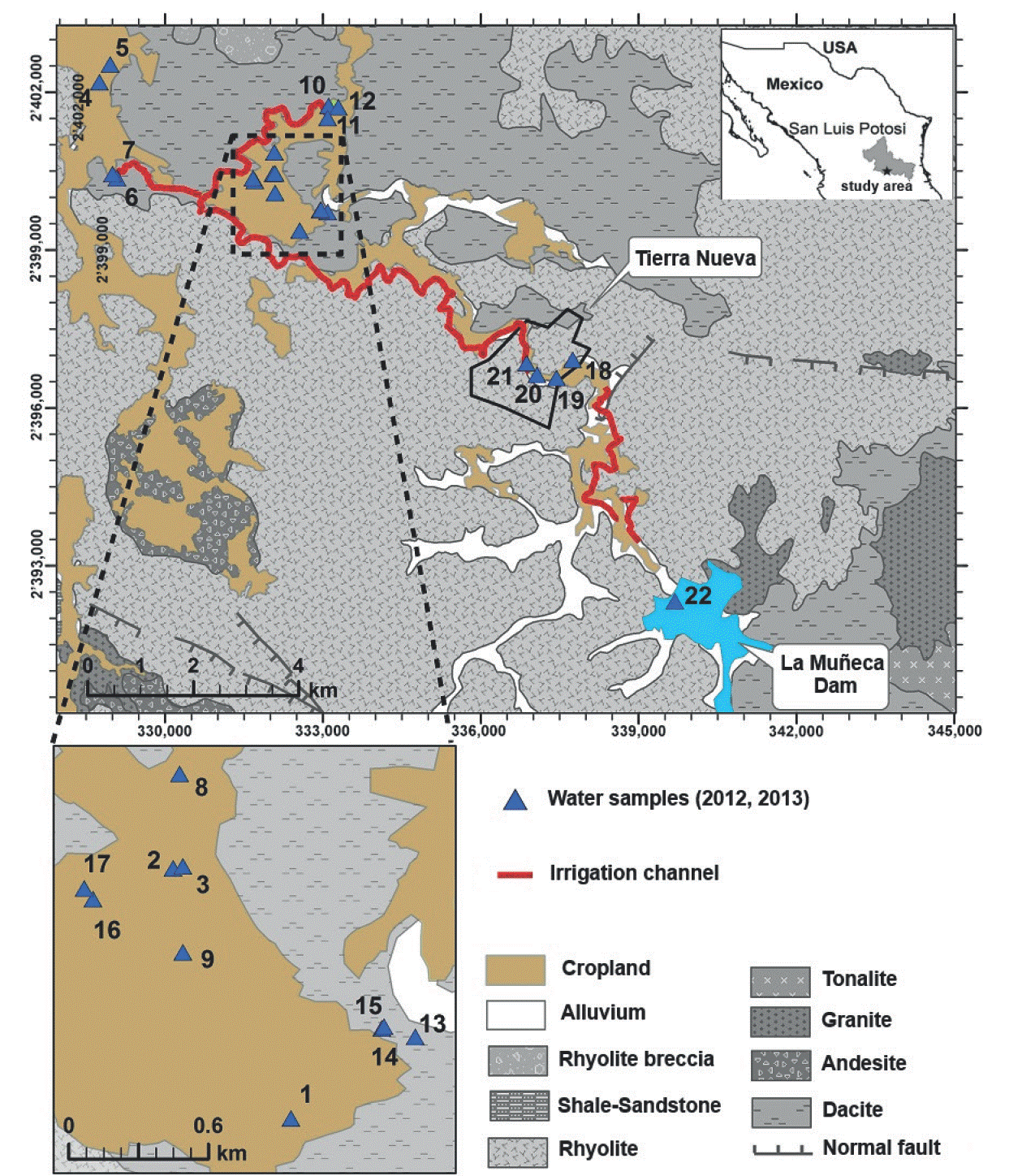
Figure 1 Location of the study area and geologic map of the Tierra Nueva area, including the distribution of water samples.
A dam named “La Muñeca” was built in the early 1970s, to store and exploit water streams of Jofre river. La Muñeca has a capacity of 31×106 m3 (Figure 1). The dam supplies water to the urban area of Tierra Nueva and 980 ha cropland through an irrigation channel. The dam area is around 2.4 km2, the urban area where Tierra Nueva is located has 1.8 km2 and the cropland occupies 5 km2. The approximate length of the water body from the dam to the cropland is 18.6 km. Low rainfall makes water from the dam insufficient to meet the demand of the agricultural sector. Thus, farmers opted to build hand-dug wells to satisfy their needs and exploit groundwater to use it with surface water to irrigate their crops.
Soil types are presented in Figure 2 (Driessen et al., 2001). Leptosol is the most widely distributed soil type in the area, whereas Feozem is located at the main course of Jofre river and its tributaries (where agriculture is developed), and Regosol is located in the northwestern part of the cropland. Currently, there is a zone where saline layers are observed on soil surface; these places are no more suitable for agriculture. Furthermore, farmers of the locality indicate that in other zones, crops do not grow as they used four years ago, both in quantity and quality.

No study has so far been carried out to explain the causes of recent salinization in this place. Water quality used for irrigation is of great importance in order to determine the convenience of its use in agriculture, which is the main economic activity in the area. Therefore, the assessment of the hydrogeochemical processes occurring in the watershed is of great importance, to advise a sustainable use of water and soil resources.
MATERIALS AND METHODS
Water sampling and analysis
The study was conducted during the same season in two consecutive years (2012 and 2013). In September 2012, 21 groundwater samples and one surface water sample from La Muñeca dam were collected. In august 2013, 16 groundwater samples and three surface water samples were collected. In both cases, standard procedures were used (APHA, 2005). The location of samples is shown in Figure 1 and is classified as cropland (1-17), urban area (18-21), and dam (22-24). Cropland sites 4, 6, 9, 12 and 16 were not sampled during 2013.
In each sampling point, groundwater level, pH, electrical conductivity and temperature were measured in situ using a calibrated YSI 556 MPS multiprobe. Alkalinity was determined by titration (alkalinity kit 3811, HI Hanna Instruments). Cations (Ca2+, K+, Mg2+, and Na+) were analyzed by optical emission spectrometry with inductively coupled plasma at Laboratorio de Geoquímica Ambiental, Universidad Nacional Autónoma de México. Anions (Cl-, F-, NO3- and PO4 3-, and SO4 2-) were analyzed by colorimetric methods at Instituto de Investigación Científica y Tecnológica A. C. (IPICYT), using a SMART 2, LaMotte equipment (2012 samples) and at Laboratory of Hydrogeochemistry, CICESE, by ion chromatography (ICS-2000, Dionex), using integration times of 6 minutes and NaOH 4 mM as eluent (2013 samples). Every sample was measured by triplicate and the standard deviation was less than 15% between replicates. Results of physicochemical analysis are shown in Table S1 of the supplemental material.
To evaluate water quality, following indices were calculated using the shown equations and water quality criteria:
1) Sodium percentage (%Na) (Wilcox, 1955).
 (1)
(1)
Criteria: <20 excellent, 20-40 good, 40-60 permissible, 60-80 doubtful, and >80 unsuitable.
2) Soluble sodium percentage (SSP) (Todd and Larry, 2005).
 (2)
(2)
Criteria: <50 good, >50 bad.
3) Residual sodium carbonate (RSC) (Eaton, 1950).
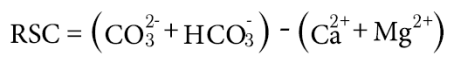 (3)
(3)
Criteria: <1.25 good, 1.25-2.5 doubtful, > 2.5 unsuitable.
4) Kelley ratio (KR) (Kelley, 1963).
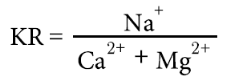 (4)
(4)
Criteria: <1 good, >1 bad.
5) Sodium adsorption ratio (SAR), (Richards, 1954).
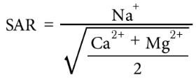 (5)
(5)
Criteria: <10, excellent (S1), 10-18 good (S2), 18-26 doubtful (S3), >26 unsuitable (S4).
6) Cation ratio of structural stability (CROSS) (Smith et al., 2015).
 (6)
(6)
For this index, no criteria is proposed, however, as the authors mentioned that CROSS could replace calculations of SAR, the same criteria was used: <10 excellent (S1), 10-18 good (S2), 18-26 doubtful (S3), >26 unsuitable (S4).
7) Permeability index (PI) (Doneen, 1964).
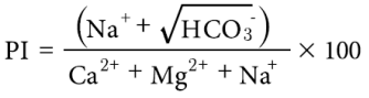 (7)
(7)
Criteria: <20 excellent, 20-40 good, 40-80 injurious, >80 unsatisfactory.
8) Magnesium adsorption ratio (MAR) (Raghunath, 1987).
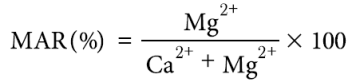 (8)
(8)
Criteria: <50 suitable, >50 unsuitable.
9) Total dissolved solids (TDS).
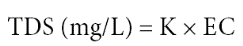 (9)
(9)
where EC is the electrical conductivity (dSm-1), K = 640 for most of the cases, K = 735 for mixed waters, and K = 800 for EC > 5 dS·m-1.
Criteria: <1,000 non saline, 1,000-3,000 slightly saline, 3,000-10,000 moderately saline, and >10,000 very saline.
10) Salinization hazard (based on conductivity) and sodicity hazard (based on SAR)
All indices are based on concentration of dissolved anions and cations, expressed in meqL-1. Results were classified according to the water quality criterion.
Statistics
Data for land use, sampling years and water quality indices were analyzed by factorial ANOVA. Variance normality and homogeneity was assumed before performing statistical data analyses. Statistical significance was determined by Tukey posteriori test at P<0.05. All statistical analyses were performed using Statistica 7.0, and graphs were generated with SigmaPlot 12.
A principal component analysis (PCA) of groundwater quality indices was performed, and the data were analyzed using standard methods. The graphic software Origin Pro version 9.1. was used to evaluate index correlations and yearly change. The PCA is based on combination of linear variables with maximum variance within data set. This analysis describes vectors that meet a number of observations within a specified dimensional space, and are orthogonal to each other (Ng, 2009). Principal components with high eigenvalues and comprising variables with high factor loading are those that better represent the system features. Hence, the principal components with eigenvalues >1 and factor loading >10% were chosen (Brejda et al., 2000). Pearson's correlation coefficients resulting from principal component analysis were used to determine strength of the relationship between calculated groundwater quality indices (Andrews and Carroll, 2001).
RESULTS
The water temperature in 2012-2013 ranged between 17.7 and 25 ºC, and averaged 20.3 ºC. The water table was between 0.3 and 8 m depth below ground level, with an average depth of 2.6 m. The shallower waters (0.3-1.5 m) were located at increasing depth at sites: 16<14<15<8, and <13. The pH ranged between 7 and 10, and averaged 8.5; most of the samples were within the normal range of natural waters of 6-8.5 (Hem, 1970). Sample 14 (pH 8.7-9.6) and 15 (pH 9.2-10) were out of range in both sampling years. These sampling points are near each other and are also close to the area where salt efflorescence was found. The similar pH values suggest a mixture between these waters.
Measured electrical conductivity (EC) was 0.3-3.8 dS·m-1 (deci-Siemens per meter), and averaged 1 dS·m-1. The proportion of cations in order of largest to lowest abundance was: Na+> Ca2+> K+> Mg2+; while that for anions was: HCO3- > CO3 2- > SO4 2- > Cl- > NO3 - > F- > PO4 3-. The correlation coefficient between sodium and EC was 0.98, between bicarbonate and EC was 0.87, and for the other ions the correlation coefficients were lower than 0.5. This is an indicator that the ions that contribute mainly to salinity are sodium and bicarbonate.
Ion concentrations were similar during both sampling years, except for Cl- that had a tenfold increase, and nitrate and sulfate which also increased significantly in 2013. The evaluation of the impact of droughts to water quality of a river in Netherland has been studied by Van Vliet and Zwolsman (2008), they found that Cl-, F- and SO4 2- increased their concentrations during droughts. This behavior was associated to their natural conservative characteristics and to the fact that they do not react in surface water. In the case of Tierra Nueva, the dam was reduced to a 15% of its capacity in 2013, leading to the concentration of these elements and transport through the main course of Jofre river and the groundwater irrigation channels. In the case of nitrates, the increase can be associated to the agricultural activities in the zone and the evaporation rates due to the drought.
According to TDS values, in 2012 94% of water samples from the cropland were non saline and the rest slightly saline, while in 2013, water quality was worse, with 83% non saline and 17% slightly saline samples (Table 1). In the urban area and the dam 100% of water samples were non saline in both years. The spatial distribution of TDS values of both sampling years is shown in Figure 3; there can be observed that the higher TDS concentrations were located in the cropland. In 2012, water samples from the cropland were slightly saline and were located in the southeastern part of the cropland, where Jofre river is close and the shallowest water table was measured (0.3 m). In Figure 3b, that corresponds to the TDS values of 2013, the concentrations in the cropland increased, except for sample 7, which has a direct connection to the dam, indicating water mixture. As shown in Figure 4, variation of TDS values between 2012 and 2013 was larger in the dam, and the highest variation of standard deviation was found in the cropland. For both land uses (dam and cropland), values increased in 2013.
Table 1 Water quality classification of samples collected in 2012 and 1013 in the Tierra Nueva area, San Luis Potosí, Mexico, based on different quality indices. Where CL - cropland, UA- urban area, D- dam, and dimless-dimensionless
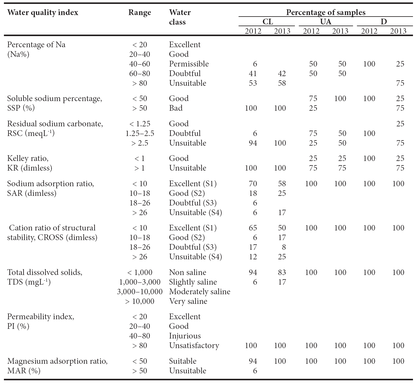
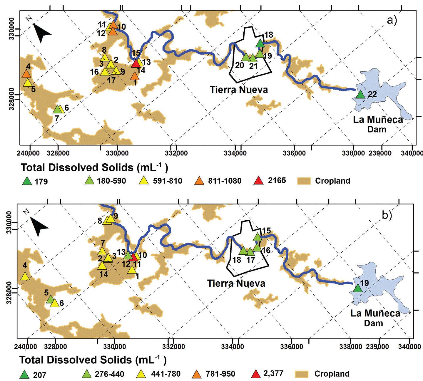
Figure 3 Spatial variation of total dissolved solids (TDS) values in Tierra Nueva, San Luis Potosí, Mexico.
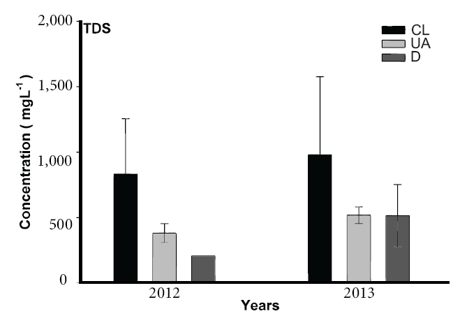
Figure 4 Graph of TDS (total dissolved solids) in mgL-1 for 2012 and 2013 samples, according to the land use. Where CL - cropland, UA - urban área and D - dam. The bars are standard deviations obtained by factorial ANOVA (P = 0.95541).
Water quality indices
Sodium percentage (%Na)
In natural waters, %Na is a common parameter that indicates whether the water is suitable for use in agriculture or not. Table 1 summarizes water quality classification of water samples based on the results of calculated indices for the three studied areas (cropland, urban area and dam). As shown in Table 1, based on %Na during 2012, 53% of the water was unsuitable, 6% permissible, and the remaining 51% was of doubtful quality. For 2013 water quality was lower, with 58% unsuitable and 42% of doubtful quality for irrigation. In the urban area, %Na indicates that 50% of the water was permissible and 50% of doubtful quality during both sampling campaigns. Finally, the only sample from the dam analyzed in 2012 exhibited %Na within the permissible range for irrigation, whereas in 2013, 25% of the samples showed permissible levels of %Na and the rest were categorized as unsuitable for irrigation. These results show that, according to the high amount of dissolved sodium, this water cannot be recommended for use in irrigation, since it will promote soil salinization.
The variation of the %Na water quality index is shown in Figure 5. It can be observed that the largest variation of %Na occurred in the dam water, which also present the highest level of dispersion (variation of the standard deviation), with an increase during 2013.
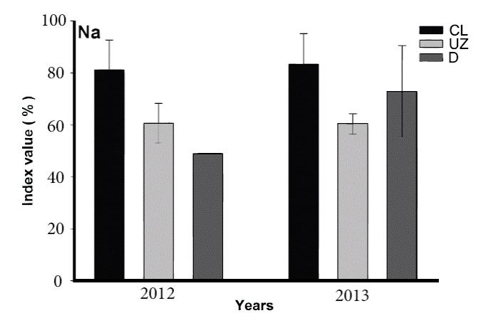
Figure 5 Graph of %Na for 2012 and 2013 samples, according to land use. Where CL - cropland, UZ - urban zone, and D - dam. The bars represent the standard deviation obtained by factorial ANOVA (P = 0.29313).
Soluble sodium percentage (SSP)
According to SSP, 100% of water from cropland was bad for irrigation during both years. In the urban area, 75% of the water was of good quality during 2012, while in 2013, 75% of the samples showed poor quality and the remaining 25 % exhibited good quality. These results are in agreement with %Na calculations, including the major variation for the dam, with increasing values in 2013 (Figure 6).
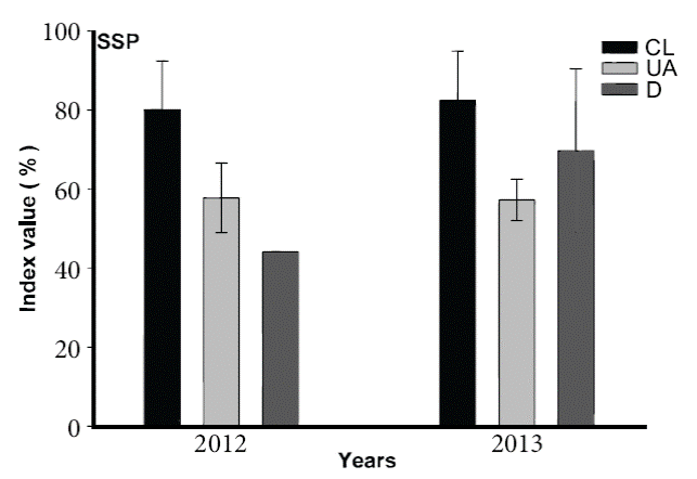
Figure 6 Graph of SSP (soluble sodium percent) for 2012 and 2013 samples, according to the land use. Where CL - cropland, UZ - urban zone and D - dam. The bars represent the standard deviation obtained by factorial ANOVA (P = 0.27464).
Magnesium adsorption ratio (MAR)
The magnesium content is considered one of the most important indicators to assess water quality for irrigation. At high concentrations of magnesium, crops are harmfully affected as soil becomes more saline (Rengasamy, 2006). Harmful effects on soils are expected when water MAR values are larger than 50 (Ayers and Wescot, 1985). As can be seen in Table 1, MAR values in the cropland during 2012 indicate 94% of the water was suitable for irrigation and 6% was not. On the other hand, for 2013, 100% was suitable for irrigation. In the urban area and the dam, 100% of water samples were suitable for irrigation. In Figure 7, this water quality index shows variation between year 2012 and 2013. As for %Na and SSP, major variation is also in the dam, with values increasing in 2013.
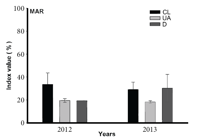
Figure 7 Graph of MAR (magnesium adsorption ratio) in percentage for 2012 and 2013 samples, according to the land use. Where CL - cropland, UZ - urban zone and D - dam. The bars represent the standard deviation obtained by factorial ANOVA (P = 0.30702).
Permeability index (PI)
The permeability index proposed by Doneen (1964) indicates susceptibility of soil to permeability loss with respect to water quality, taking into account dissolved ions that can easily precipitate (expressed in percentage). Soil permeability is affected by a long-term use of irrigation water, depending on soil type and quality of the water used for irrigation. This index is calculated based on Na+, Ca2+, Mg2+ and bicarbonate content of water. Values of PI for the cropland, urban area and dam are unsatisfactory for 100% of the samples (Table 1), in other words, water should not be used for irrigation according to this index. Figure 8, shows the PI variation between year 2012 and 2013. Again, the major variation is observed in the dam, but in contrast with %Na, SSP and MAR, there is a reduction in values for 2013.
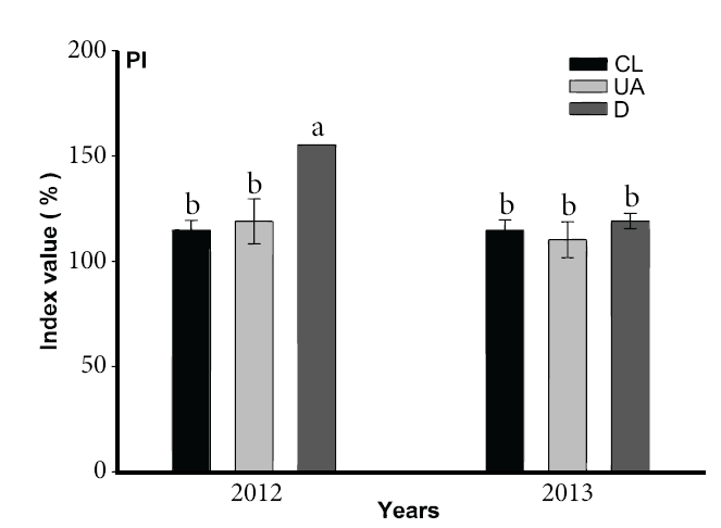
Figure 8 Graph of PI (permeability index) in percentage for 2012 and 2013 samples, according to the land use. Where CL - cropland, UZ - urban zone and D - dam. The bars represent the standard deviation, and values with different letters indicate significant differences obtained by factorial ANOVA (P = 0.00004 and Tukey a posteriori test).
Kelley ratio (KR)
This ratio is based on the premise that as the concentration of Na increases, Na+ tends to replace Ca2+. Continued irrigation and rain leach out the replaced Ca2+with the resulting dispersion of the soil, where Ca2+ plays a significant role in the mineral nutrition of plants. Likewise, the uptake of K+ is stimulated, while the absorption of Na+ is repressed, by Ca2+, even when the concentration of Ca2+ is very low (Kelley, 1963). According to KR, all samples from the cropland were unsuitable in both years of sampling (Table 1). In the urban area, 75% of water samples are unsuitable for irrigation and 25% were of good quality in both years. Water from the dam was of good quality in 2012, and in 2013, 25% of water was of good quality and 75% was unsuitable for irrigation. In Figure 9, variation in the KR values between year 2012 and 2013 are evident, with the highest variation in the cropland, with an increment of values in year 2013.
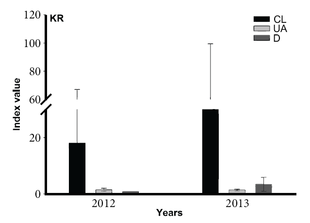
Figure 9 Graph of KR (Kelley ratio), dimensionless, for 2012 and 2013 samples, according to the land use. Where CL - cropland, UZ - urban zone and D - dam. The bars represent the standard deviation obtained by factorial ANOVA (P = 0.95083).
Sodium adsorption ratio (SAR)
In 1954, Richards proposed this ratio as an indicator of adsorption of sodium by soil and soil structure damage. A higher proportion of Na+ related to Ca2+ and Mg2+ affects the suitability of water for crops. This ratio is used to calculate the degree to which cations dissolved in irrigation water tend to enter into cation exchange sites in soil. The main problem with high sodium concentrations, as mentioned before, is its effect on soil permeability. Sodium also contributes directly to total salinity of water and may be toxic to sensitive crops. As can be observed in Table 1, unlike the other indices, SAR values indicate that in the cropland 70% of water was of excellent quality and 6% was unsuitable for irrigation during 2012. In year 2013, 58% was of excellent quality and 17% unsuitable for irrigation. In the urban area and the dam, 100% of water samples were of excellent quality. Figure 10, shows the variation of SAR between 2012 and 2013. Here, the highest variation was in the cropland, with an increase in year 2013.
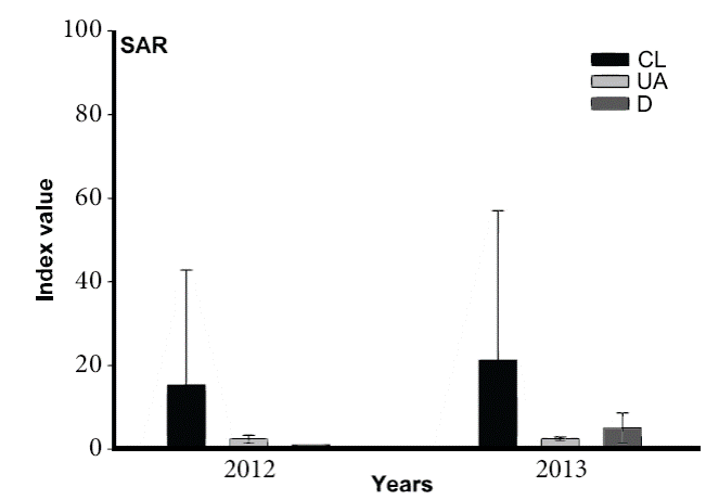
Figure 10 Graph of SAR (sodium adsorption ratio) dimensionless for 2012 and 2013 samples, according to the land use. Where CL - cropland, UZ - urban zone and D - dam. The bars represent the standard deviation obtained by factorial ANOVA (P = 0.96551).
Cation ratio of structural stability (CROSS)
This index takes into account not only Na+, Ca2+ and Mg2+, but also K+ (Smith et al., 2015). Authors suggest using CROSS (optimized) as water quality index instead of SAR, on the basis that hydraulic conductivity of K+-modified soils is overestimated by SAR and that problems with soil physical properties caused by waters with high concentrations of K+ have been reported since more than 50 years (Reeve et al., 1954).
In Table 1, CROSS values evaluated with SAR criteria indicate that in the cropland 65% of water was of excellent quality and 12% was unsuitable for irrigation in 2012. In 2013, 50% was of excellent quality and 25% unsuitable for irrigation. In the urban area and the dam, 100% of water samples were of excellent quality. Results are very similar to those based on SAR, but opposite to the obtained with other indices. In Figure 11, CROSS shows variation between 2012 and 2013. As with SAR, the highest variation was in the cropland, with an increase in 2013.
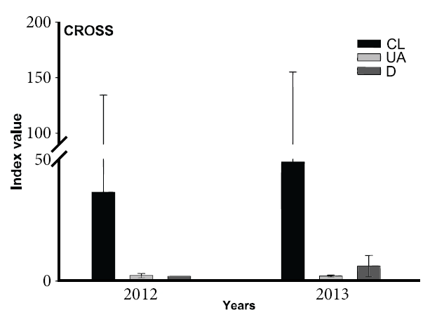
Figure 11 Graph of CROSS (cation ratio of structural stability) dimensionless for 2012 and 2013 samples, according to the land use. Where CL - cropland, UZ - urban zone and D - dam. The bars represent the standard deviation obtained by factorial ANOVA (P = 0.98347).
Residual sodium carbonate (RSC)
Residual sodium carbonate is defined as the residue of carbonate that is combined with sodium, when Ca2+ and Mg2+ precipitated, caused by evaporation and plant uptake. This may happen when water has more carbonate and bicarbonate than Ca2+ and Mg2+. The presence of carbonate and bicarbonate in irrigation water represents a loss of fertility risk, owing to deposition of sodium carbonate. Water with high RSC has high pH and higher potential of sodium hazard (Eaton, 1950). Values of RCS for the cropland in 2012 indicate that 94% of the water is unsuitable for irrigation and 6% is of doubtful quality (Table 1). For 2013, 100% of the water in the cropland was unsuitable for irrigation. In the urban area, during 2012, 25% of water was unsuitable for irrigation and the rest was of doubtful quality; whereas in 2013, 50% was unsuitable for irrigation, and the remaining 50% was of doubtful quality. During 2012, dam water was of doubtful quality, and during 2013, 25% of the water was of good quality and 75% was unsuitable for irrigation. In Figure 12, water quality index shows variation between 2012 and 2013. Major variation was also in the cropland, with an increase in 2013; however, variation is less than for SAR and CROSS.

Salinization hazard (based on EC) and sodicity hazard (based on SAR)
The Salinity Laboratory of United States proposed a classification for irrigation water quality based on electrical conductivity (EC) of water and sodium adsorption risk (SAR) (Richards, 1954). This can be evaluated when these parameters are plotted on a diagram, in which EC represents salinity hazard and SAR sodicity hazard; the interpretation is based on the work of Dhok et al. (2011).
Observing the diagram (Figure 13), samples from the urban area, the dam and sample 7 from the cropland represent medium salinization hazard (C2) and low sodium hazard (S1). It is important to mention, that sample number 7 from the cropland is mixed with water from the dam through a cement channel that distributes dam water to the cropland; therefore, this sample shows a quality similar to that of dam water. Type C2 represents an average salinity water that can normally be used whenever there is a moderate degree of washing. It can be used to irrigate crops that are moderately tolerant to salts without any danger of salinization. Class S1 can be used for irrigation in most soils with little chance of reaching dangerous levels of exchangeable sodium.
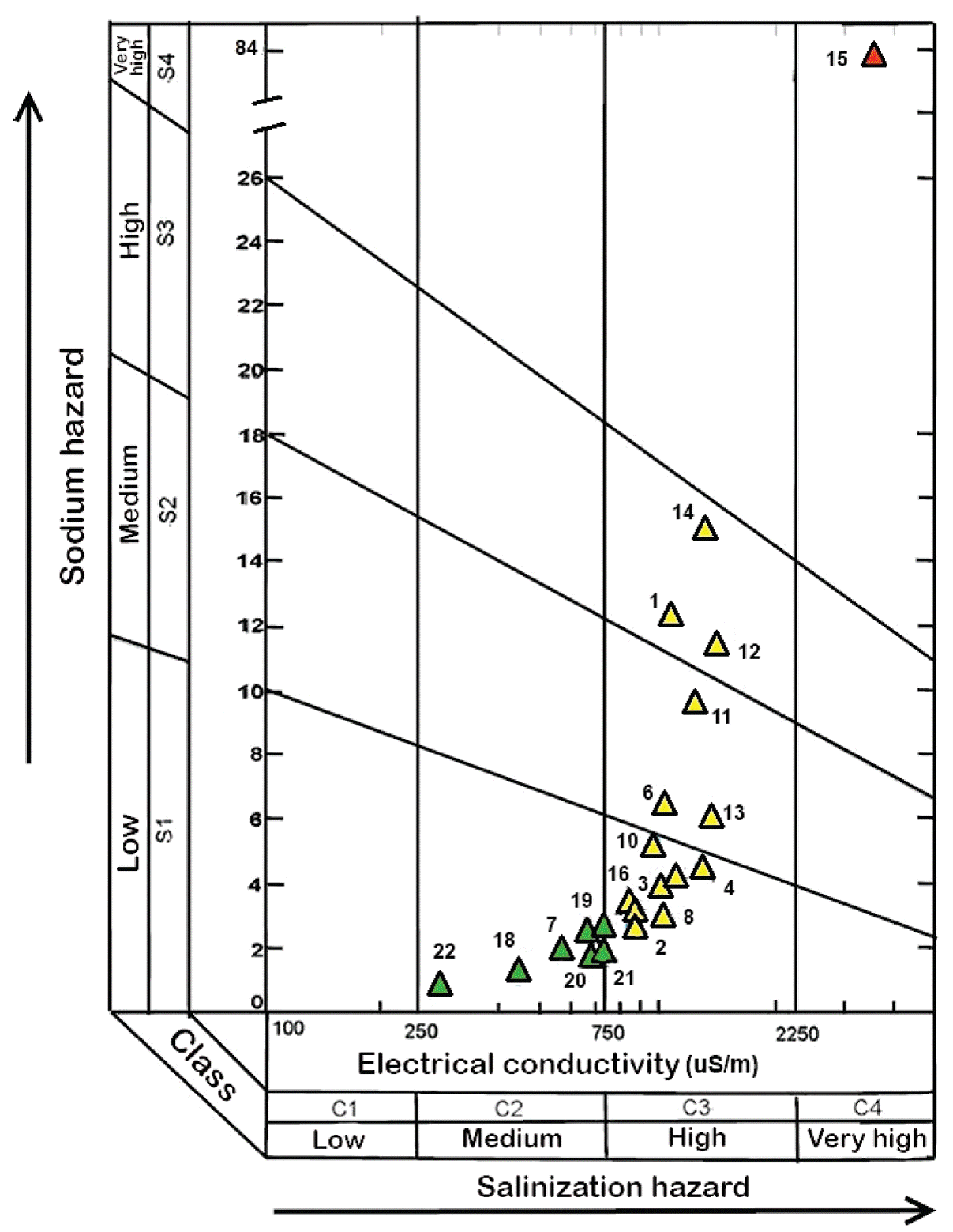
Figure 13 Classification of irrigation water based on the electrical conductivity and the sodium adsorption ratio.
Nine samples from the cropland signal high salinization hazard (C3) and low sodium hazard (S1). Water type C3, cannot be used in soils with poor drainage. Even with proper drainage they may need special practices for salinity control, as selection of salt tolerant plants.
From the cropland, samples 11, 13 and 6 indicate high salinization (C3) and sodium hazard (S2). Class S2 in fine textured soils with high capacity for ion exchange, sodium represents a significant hazard. These waters can be used in coarse textured soils or organic soils with good permeability.
Sample 15 denotes very high salinization (C4) and sodium hazard (S4). Water of the C4 type is inappropriate for irrigation under ordinary conditions, but may be used under very special circumstances. Soil must be permeable with proper drainage and excess of water should always be used to achieve a good washing. Salt tolerant crops must be selected, although class S4 is generally unsuitable for irrigation purposes.
In general, salinization hazard is of medium level for samples from the dam and urban areas. For the cropland, however, a high salinization hazard and tendency of increment in sodium hazard along the Jofre river and western site of the cropland are identified. Sample 15 poses very high salinization and sodium hazard. It is in this place that salt efflorescence and soil salinization were located.
Statistics
Factorial variance analysis
Data for water quality indices and TDS were used to perform a factorial variance analysis expressed in graphs presented in Figures 4 to 12. In each graph, P value is noted. Values of P < 0.05 indicate that data present a significant variation. This is the case of PI (Figure 8), P was equal to 0.00004; Tukey posteriori test revealed significant differences in data for dam samples. However, the bars representing the standard deviation are smaller than in graphs of other water quality indices such as %Na (Figure 5), SSP (Figure 6) and RSC (Figure 12).
On the other hand, indices that present high variability on standard deviation in the cropland data were: KR (Figure 9), SAR (Figure 10), CROSS (Figure 11), RSC (Figure 12) and TDS (Figure 4). In all these cases, P values higher than 0.05, considered to indicate no significant variations. With this variance analysis, higher values can be identified according to land use and sampling year. Three behaviors were observed:
Values of the cropland were higher than in other locations, and in 2012 those values suffered an increment. This was the case of MAR (Figure 7)
Values of the dam were higher than in other locations, and in 2012 those values suffered an increment. This was the case of PI (Figure 8)
Values of the cropland were higher than in other locations, and in 2013 those values suffered an increment. This was the case of %Na (Figure 5), SSP (Figure 6), KR (Figure 9), SAR (Figure 10), CROSS (Figure 11), RSC (Figure 12), TDS (Figure 4).
These results were expected, since soil salinization has been detected in the cropland. As mentioned before, in 2013 a severe drought caused a decrease in the dam water level down to 15% of its total capacity. This caused an increase in the concentration of dissolved ions; therefore, it is not surprising that the indices were higher in that year.
What was unexpected is the fact that MAR and PI water quality indices presented lower values in 2013 in the cropland and in the dam, respectively. These are indicators mainly related to magnesium concentrations and to the susceptibility of permeability loss of the soil, which are probably independent of the drought.
It is also important to point out that in the case of PI (Figure 8), values for the urban zone were higher than values for the cropland in 2012. This was the only case where the water quality index of the urban area was higher than the values of the cropland. It could be associated to additional anthropogenic impact.
Principal component analysis
This analysis was made for all samples (cropland, urban and dam) and the results are shown in Figure 14a and 14b, the eigenvectors of variables from the principal component analysis are shown. The two principal components represent the behavior of 85.5% of the 2012 data and 85.9% of the 2013 data.
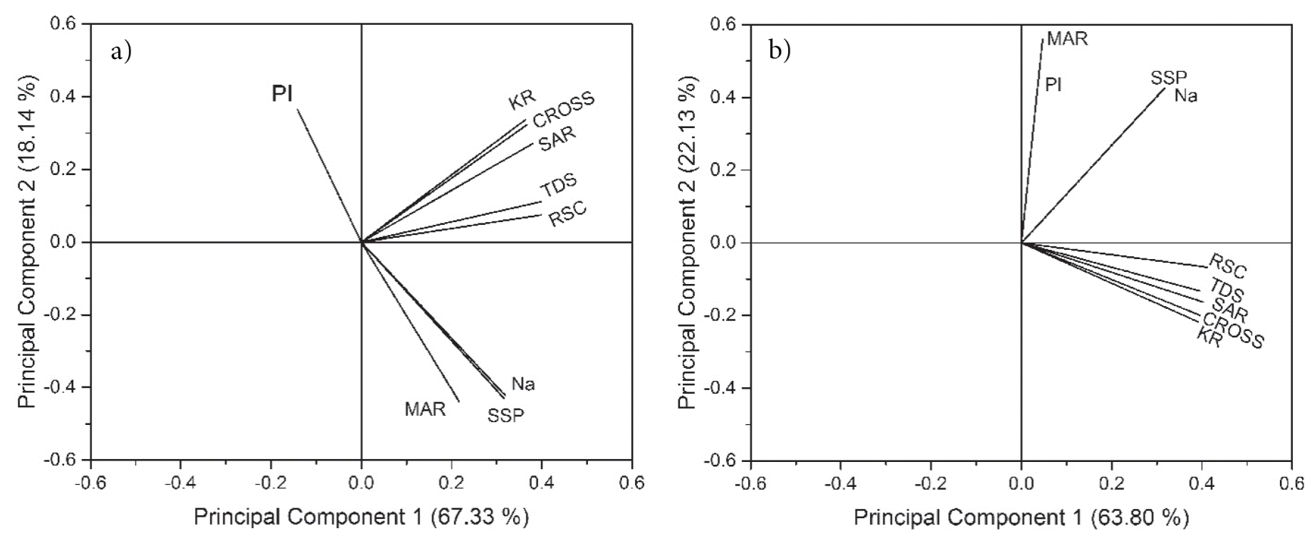
Figure 14 Principal component analyses of the eight quality indices for irrigation water. (a) Data from year 2012; (b) Data from year 2013.
In the graph for 2012, PI is not positively related to any of the other indices; however, there is a negative correlation with %Na, SSP and MAR. Also, factorial variance analysis revealed that the PI presented significant variability. The CROSS index, which is recommended instead of SAR (Smith et al., 2015), shows a closest similarity to KR, although all three indices appear to have a strong correlation. A similar case is observed for RSC and TDS, which are also correlated but with a stronger contribution from principal component 1. Another important factor is the separation between the group of KR, CROSS, SAR, TDS and RSC, and the group of %Na, SSP and MAR, although both are influenced by the principal component 1, the first group is influenced positively by the principal component 2 and the second group is influenced negatively.
A similar behavior was expected for 2013, as concentrations of most cations did not present significant variations. However, principal component analysis (PCA) revealed that the PI and the MAR indices are positively and closely related. The difference between years 2012 and 2013 can be attributed to the variability of both}} water quality indices in year 2012, caused by the nature of the waters at the sampling time. For the case of SSP and %Na, these are positively controlled by the principal component 1 and 2. However, the group of RSC, TDS, SAR, CROSS and KR are positively influenced by the principal component 1 and negatively by the principal component 2.
Analysis indicates that SAR is not related to PI; also, SAR revealed an excellent quality of water for irrigation, while PI revealed an unsuitable water quality. In contrast, in 2013, PI is closely related to MAR, which suggest that Mg played an important role in the risk of soil permeability decrease in this area. Nevertheless, according to MAR, irrigation water was suitable during this year and unsuitable according to PI.
Soil salinization
Piper diagrams were used to assess salinization process due to irrigation water quality. In Figure 15 one can observe that samples are grouped into three types of water: calcium-bicarbonate, calcium-sodium-bicarbonate, and sodium-bicarbonate. Water samples collected in the second campaign (2013) had more chlorine than those collected in 2012, which is an indicator of evaporation under normal conditions (Singh et al., 2015). In Piper diagrams, the blue symbols correspond to the dam, the green to the urban area, the black to the cropland; the red symbol represents the composition of sample 15, collected in the area with salt efflorescence on soil. This shows that samples of the dam are of the calcium-bicarbonate type and waters from the cropland are of the mainly sodium-bicarbonate type, passing through the urban area as calcium-sodium-bicarbonate waters. The evolution of waters from Ca-HCO3- to Na-HCO3- types suggests a possible cationic exchange of Ca2+ for Na+. Sample 15 has the highest water salinity and worst quality, as shown by the all water quality indices (Figure 13 and Table S2 of the supplemental material).
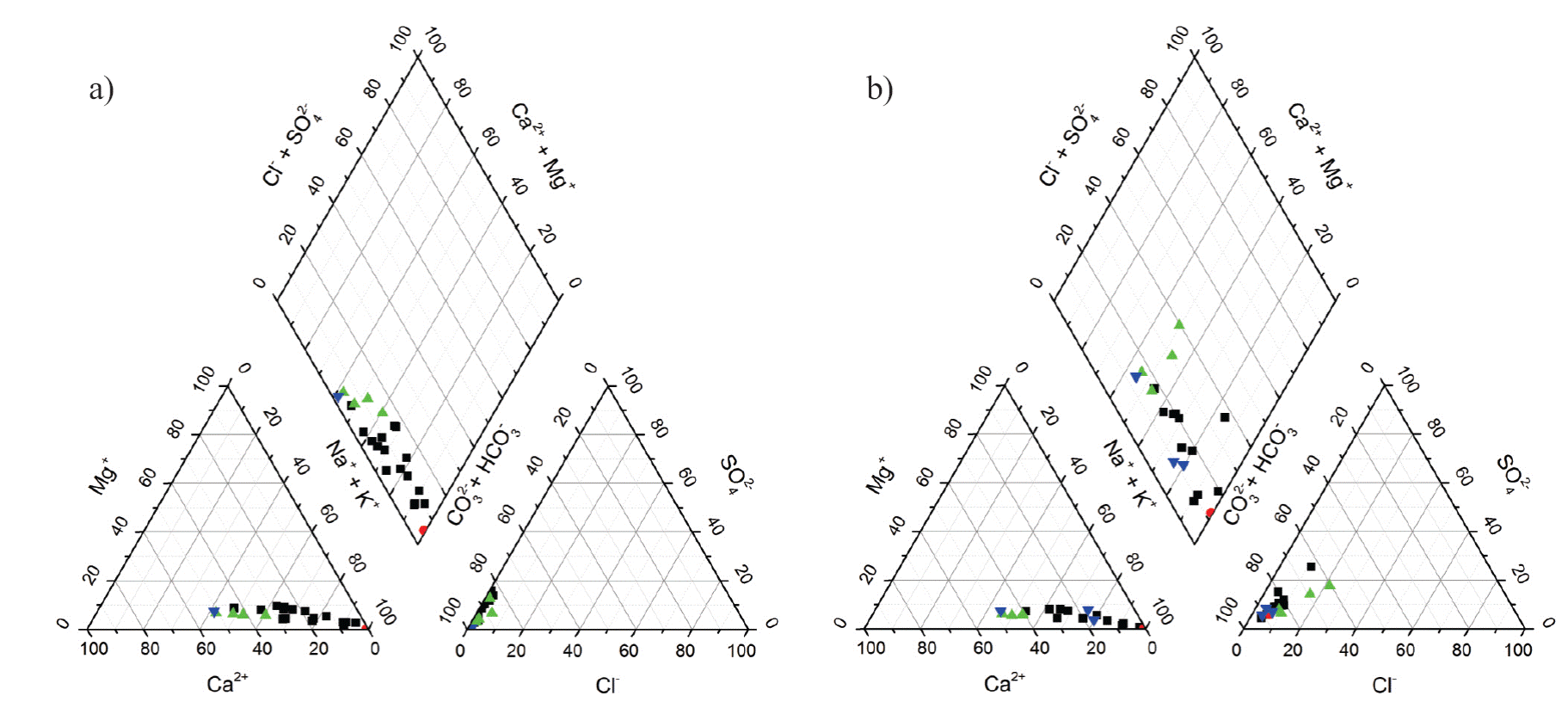
Figure 15 Piper diagrams of water samples from the Tierra Nueva area. a) sampling year 2012, b) sampling year 2013. Black squares represent cropland samples, green triangles urban area samples, and blue triangles dam samples. The red dot represents the composition of cropland sample 15, collected in the area with salt efflorescence on soil.
To recognize the natural controlling processes of water chemistry, the Gibbs diagram is used, which consist in the comparison between TDS and the ratio of Na+/(Ca2++Na+). It gives valuable information about the main natural factors that alter water chemistry such as, rainfall, weathering and evaporation. In Figure 16, the Gibbs diagram shows that the predominant chemical process is water-rock interaction, with all samples, inclusive sample 15, in the rock domain. Evaporation, indicated by the positive trend, promoted an increase in dissolved ion concentrations and eventually soil salinization.
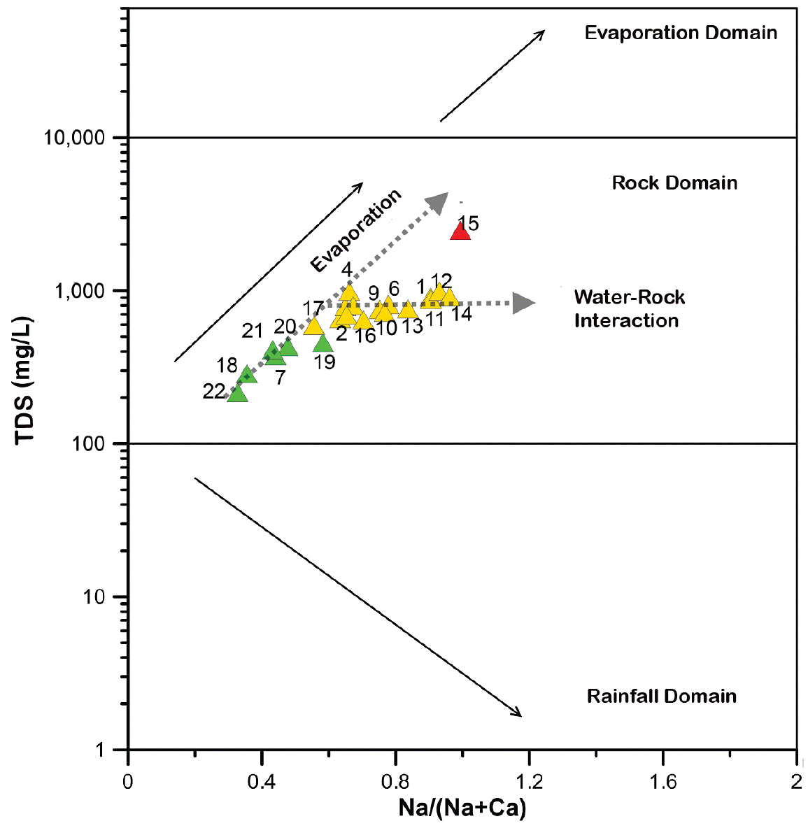
Figure 16 Gibbs diagram of water samples from the Tierra Nueva area. Colors represents the different processes of a group of samples, where green is evaporation, and yellow is water-rock interaction. The red symbol corresponds to the sample collected in the area with salt efflorescence on soil. Sample numbers are indicated close to the symbols.
DISCUSSION
Water quality
Natural environmental topographies, groundwater level and groundwater salinity have been considered as key factors of soil salinization. When groundwater level is less than 2.5 m, development of saline soils might be driven by groundwater depth and TDS. Such is the case of soil salinization in the Yellow River Delta, China, where shallow groundwater zones present the highest TDS concentrations. The rise in TDS concentrations was related to seawater intrusion and tidal variations (Fan et al., 2012). Another example is Nestos River Delta in Greece, that presents a soil salinization problem due to long-term irrigation with saline groundwater (Gkiougkis et al., 2015).
There are also reports of soil salinization problems associated with water table rise in areas that are not located close to the ocean. This is the case of regions bounded by the rivers Krishna, Warana and Yerala in India. Where the shallow groundwater table extends from 1 to 10 m, and the wells with the lowest water table (less than 3 m) presented high electrical conductivities (2-5 dS·m-1), an indicator that these areas are acting as sinks in salt transport mechanism (Patil and Nagarajan, 2015). Other example is in Delta and Lower Senegal River Valley from Mauritania and Senegal, where shallow saline groundwater and inappropriate management of irrigation water has caused a large salinization damage to soil (Moctar et al., 2015). The Aral Sea basin, which is considered as the fourth largest fresh-water lake in the world, experienced a rapid drying out due to many years of mismanagement of land and water resources. In year 2007, Ibrakhimov et al. performed a detailed analysis of the relationship between groundwater table and salinity in this region, where groundwater levels were between 0.57 and 1.48 m depth and suggested that elevated groundwater levels forced soil salinization, adding annually between 3.5 to 14 ton·ha-1 of salts to the soils, depending of level and salinity of the water table. Of course this is an extreme case; however, the mismanagement of natural resources can lead to such cases.
In the Tierra Nueva area we found shallow groundwater levels (less than 1.6 m) in sampling points 8, 13, 14, 15 and 16 (Figure 1). Sampling points 13, 14 and 15 are close to each other in the southeastern part of the cropland, while sampling points 8 and 16 are located on the northwestern part (Figure 1). For 2012 and 2013, respectively, sampling site 14 had TDS values of 874 and 1,208 mg·L-1, and sampling site 15 of 2,376 and 2,813 mg·L-1. Thus, sample 15 is classified as brackish water in both sampling years and sample 14 only in sampling year 2013, according to the water classification by Fan et al. (2012). The remained water samples are classified as freshwaters. This suggests that in sampling points 8 and 16, soil salinization processes are not associated to water table rise.
Electrical conductivity measured in the water samples ranges from 0.3 to 3.8 dS·m-1. In cases where no immediate actions can be undertaken to mitigate soil salinization process due to irrigation, an alternative is to cultivate a salt tolerant crops (Singh, 2015; Ahmad and Prasad, 2013). For example, crops such as quinoa can develop under extreme conditions of salinization from shallow groundwater with EC up to 40 dS·m-1 (Talebnejad and Sepaskhah, 2015). Maize is more sensible with reductions by 25% of crop yield with EC up to 0.81 dS·m-1 (Suresh and Nagesh, 2015). At seedling stage, sorghum had a 50% lower crop yield at EC up to 11 dS·m-1 (Saadat and Homaee, 2015) while cotton has a tolerance limit of EC up to 7.7 dS·m-1 (Palomo-Rodríguez et al., 2013). Salinity tolerance of crops commonly cultivated in Mexico according to EC values can be consulted in Cortés-Jímenez et al. (2009).
To decide if groundwater is suitable for irrigation on the basis of water quality indices, one can either calculate the global water quality index (WQI) by Kannel et al. (2007), where all indices are summarized, or use the method by Kumari et al. (2013) who suggest that if one of the indices indicates a doubtful or bad water quality, this water should be considered unsuitable for irrigation (even if the rest of the calculated indices indicates good water quality). By applying the criteria of Kumari et al. (2013), all samples from the cropland studied here are unsuitable for irrigation purposes, and 75% of the samples from the urban area and the dam samples are unsuitable for irrigation.
The negative correlation between PI and %Na, SSP and MAR for 2012 was unexpected, since these indices have a direct impact on soil permeability (Aghazadeh and Mogaddam, 2010; Obiefuna and Sheriff, 2011; Gowd, 2005). Irrigation water with high Na% reduces crop growth and reacts with soil, reducing its permeability (Joshi et al., 2009). However, taking into account that adsorption of Na by clay minerals and soils increases at higher Mg:Ca ratios; when MAR values are higher than 4, more Na+ is adsorbed since the bonding energy of Mg2+ is less than that of Ca2+ (Michael, 2009). In this study, the lowest value of MAR in 2012 was 18 and in 2013 was 17, allowing more sodium to be adsorbed. It has also been demonstrated that salinity risk can be assessed with the calculation of SAR, which represents the degree of water alkalization and the decrement of soil permeability (Moctar et al., 2015). However, in our study, SAR was not correlated with PI.
In this study, the evaluation of eight water quality indices is proposed, since the methodologies to assess water quality for irrigation are not well defined. In some reports, those indices are calculated for one or more sampling periods, normally complemented by physicochemical parameters such as T, pH, EC and TDS, among others. The most widely used water quality indices are RSC and SAR, sometimes complemented with other water quality indices such as PI (Kumari et al., 2013), or with PI, %Na (Patil and Nagarajan, 2015) or with PI, KR, MAR, SSP and total hardness (Docheshmeh and Vadiati, 2014). In other cases the results are statistically analyzed, mainly by hierarchical cluster analysis (Zhang et al., 2012; Docheshmeh and Vadiati, 2014), correlation analysis (Kumar et al., 2007) and variance (Kirankumar and Karunashree, 2015). The results will also depend on the specific site characteristics, which makes for a more difficult standardization of assessment methods and comparisons.
In Mexico, the Instituto Nacional de Investigaciones Forestales, Agrícolas y Pecuarias (INIFAP), investigated the correlation between water quality indicators for water irrigation usage (Cortés-Jimenez et al., 2009). They reported correlations of 164 water analyses for the following indicators: SAR and adjusted SAR, RSC, effective and potential salinity, PI, exchangeable Na percent, and %Na. They conclude that EC and SAR are the more suitable criteria, enough and simple to evaluate irrigation water quality (Cortés-Jimenez et al., 2009). However, in order to understand the processes leading to soil salinization and propose strategies of mitigation, a detailed assessment has to be performed, including more than three water quality indices and soil analyses.
Soil salinization
Samples from the dam are calcium-bicarbonate and the water from the cropland is mainly sodium-bicarbonate, passing through the urban area as calcium-sodium-bicarbonate water. This behavior suggests a possible cationic exchange between Ca2+ and Na+, documented before by Cates et al. (1996). This implies that Na+ dissolves from the geologic media while sorption of Ca2+ by the geologic media occurs.
Schoeller (1965) proposed the Base Exchange Index (CAI, chloro-alkaline index) to interpret ionic exchange between groundwater and geologic media, which is calculated as: CAI = [Cl-(Na+ + K+)] / Cl- with concentrations expressed in meqL-1. Positive CAI values indicate exchange of Na+ and K+ from water with Ca2+ and Mg2+ from rocks and negative values indicate exchange of Ca2+ and Mg2+ from water with Na+ and K+ from rocks, as it has been shown elsewhere (Nagaraju et al., 2006). For water samples in this study the CAI is negative in all cases, with values ranging between -5 to -126, confirming what is observed in the Piper diagrams. Water from the dam, which originally is of the calcium-carbonate type, evolves to the type sodium-bicarbonate, increasing the sodification hazard for the soil (Richards, 1954).
Other factors affecting water quality and promoting soil salinization
The population growth rate in San Luis Potosí state in the last 15 years (2000-2015) is of 28,000 person/year. This has caused an increase in clean water demand from 5.2 m3·s-1 (1995) to 6.2 m3·s-1 (2013) (INEGI, 2015). The population of Tierra Nueva depended on groundwater supply from the Santa María del Río aquifer, which has an annual media availability of -13×106 m3, with annual recharge of 3.7x10⁶ m3·y-1 and availability index of -3.5x10⁶ m3, which means that the recharge is not enough to supply the demand of this region (CONAGUA, 2015). To balance this water demand, La Muñeca Dam was constructed. However, rainfall scarcity is promoting chemical changes in water quality, as shown in this work, accelerating soil salinization processes due to irrigation.
Thirteen municipalities located in the southeastern part of the San Luis Potosí state are catalogued as high vulnerable to climate change. According to the report of Centro de Ciencias de la Atmósfera de la UNAM (Fernández-Eguiarte et al., 2015), Tierra Nueva has medium climatic exposition, low climatic sensitivity to climate change, high adaptive capacity to climate change, and low vulnerability to climate change. These is good for the region in terms of exposition to this phenomena, however, long-term monitoring should be addressed in this zone. The authors consider that the results presented in this paper can be taken into account to include the Santa María del Río aquifer in the Comisión Nacional del Agua national inventory of aquifers with marine intrusions or under phenomena of soil salinization and saline groundwater (CONAGUA, 2013).
CONCLUSIONS
The evaluation of the water quality using two or three quality indices is not enough and to elucidate the processes leading to soil salinization and propose strategies for mitigation a more detailed assessment is required, including soil analyses.
According to the evaluated water quality indices for the Tierra Nueva area, San Luis Potosí, water from the cropland is unsuitable for irrigation purposes. In the urban area and in the dam 75% of the respective samples are unsuitable for irrigation. The main index taken into account to conclude this was Permeability index (PI).
Water from the dam “La Muñeca” is classified as calcium-bicarbonate type, which changed to sodium-calcium-bicarbonate type when it flowed through the urban area, and evolved to sodium-bicarbonate type in the cropland. This increased the sodification hazard for soil. The predominant chemical processes are water-rock interaction and evaporation, which promoted an increase in the concentration of dissolved ions and eventually soil salinization.
Shallow groundwaters in the southeastern part of the cropland are classified as brackish according to their total dissolved solids values and as C4S4 (high) according to their salinization and sodium hazard. This is the probable cause for precipitation of natrite (Na2CO3) in the topsoil.

