


 text new page (beta)
 English (pdf)
 Article in xml format
 Article references
 Send this article by e-mail
 Cited by SciELO
  Similars in
SciELO
Similars in
SciELO 
 Permalink
INTRODUCTION
Apatite fission track (AFT) thermochronology is applied in orogenic belts and extension zones to calculate exhumation, fault tilting, erosion and sedimentation rates, as well as to model low temperature cooling histories. Numerous AFT thermochronological studies of the granitic basement of the Basin and Range Province along the western North-American Cordillera, combined with structural mapping and dating of the overlying Cenozoic volcanic deposits, have documented with high precision the timing of normal faulting, exhumation rate and tectonic unroofing of upper and middle crust (Stockli, 2005 and references herein). The southern part of the Basin and Range province, located in northwestern Mexico is also a suitable region to apply AFT analysis to extensional tectonics. This region has recorded the exhumation of Cretaceous and Cenozoic intrusive rocks during the Late Oligocene-Miocene Basin and Range extension and the Late Miocene to present-day opening of the Gulf of California. In order to test the imprint of both extensional processes in Sonora, fifteen samples of granitic rocks were dated using the AFT technique in two distinct areas: The Cerro Bachoco, located at the eastern limit of the Gulf of California extensional province, and the Sierra La Madera, the easternmost range belonging to the Basin and Range province, immediately west of the Sierra Madre Occidental (Figure 1).
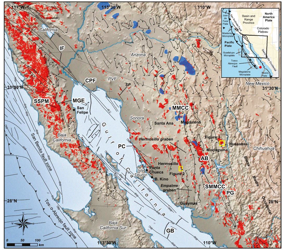
Figure 1 Simplified tectonic framework of northwestern Mexico and southwestern USA: From west to east: 1) The paleotrench of subduction of Farallon plate and Guadalupe microplate; right-lateral fault zone along the Pacific margin of Baja California Peninsula; 2) the Peninsular range batholith in red, limited to the east by the Main Gulf Escarpment; 3) The Gulf of California, which corresponds to the right-lateral transform plate boundary between Pacific and North America plates. This transform fault zone connects to the north with the Cerro Prieto and Imperial fault zone, which connect themselves with the San Andreas fault system at Salton trough; 4) the Basin and Range province between the coast of Sonora and the Sierra Madre Occidental which is characterized by a north-south to northwest-southeast oriented pattern of normal faults. Faults are classified in two end-members groups: high-angle normal faults and low-angle detachment faults, which are generally related to metamorphic core complexes (in blue). The metamorphic core complexes define a high extension belt along the entire Cordillera until the Mazatán metamorphic core complex, 80 km east of Hermosillo. Many of the Laramide plutons of Sonora are limited by normal faults associated with the Basin and Range extension. Mapping of normal faults is modified from Stewart and Roldán-Quintana (1994). Yellow rectangles are the study areas Sierra El Bachoco (1) and Sierra La Madera (2). AB: Aconchi batholith; B. Kino: Bahía de Kino; CPF: Cerro Prieto fault; GB: Guaymas basin; IF: Imperial fault; MMCC: Magdalena metamorphic core complex; MGE: Main Gulf Escarpment; PC: Punta Cirios; PG: Potrero de Galindo; PVF: Pinacate volcanic field; SMMCC: Sierra Mazatán metamorphic core complex; SP: Sierra Pinta; SSPM: Sierra San Pedro Martír. The red dot in the insert indicates the Los Cabos block.
CRETACEOUS TO TERTIARY GEOLOGICAL SETTING
Since Cretaceous time, northwestern Mexico has experienced a magmatic and tectonic evolution related to the subduction of the Farallon plate beneath the North America plate. During Late Cretaceous and Paleogene, large volumes of intrusive and volcanic rocks were emplaced and erupted to form the Laramide magmatic arc (Figure 1). Volcanic rocks are grouped in Sonora as the Tarahumara Formation (Wilson and Rocha, 1949) and correspond grossly to the Lower Volcanic Group of the Sierra Madre Occidental area (McDowell and Keizer, 1977). From 90 to 40 Ma, the geodynamic cause for the Laramide uplift (English and Johnston, 2008) has been attributed to both rapid subduction of the Farallon plate beneath the margin of western North America (Coney and Reynolds, 1977; Engebretson et al., 1985), as well as the progressive decrease of subduction angle (Keith, 1978) and the approximately 800 km long eastwards migration of the magmatic arc from Baja California to Chihuahua. The Laramide igneous activity ceased during Eocene in Chihuahua where some plutons and volcanic sections are reported (McDowell and Mauger, 1994). The Eocene volcanism is well exposed in Chihuahua, and some outcrops are described and dated in southeastern Sonora (Montigny et al., 1987; Gans, 1997), consisting of thick ignimbrites and dacites. After the Oligocene-early Miocene volcanic flare-up of the Sierra Madre Occidental, magmatism migrated westwards through central Sonora (Till, 2005) and reached eastern Baja California when it was still part of the continent.
Late Oligocene Miocene magmatism is contemporaneous with the continental-scale extension within the Basin and Range Province, which is characterized by elongated ranges and basins, delimited by normal faults (Figure 1). The Basin and Range province extends from northwestern United States over south-central Mexico to at least the Trans-Mexican Volcanic belt and probably further south, to Oaxaca (Henry and Aranda-Gómez, 1992). The age of Basin and Range extension in Sonora is bracketed between Late Oligocene and Late Miocene, and is contemporaneous with the subduction of the Farallon plate and associated microplates beneath the North America plate. The end of Basin and Range extension may coincide with the change of relative motion between Pacific and North America plates and the rupture of the lithosphere previous to the opening of the Gulf of California. Stewart and Roldán-Quintana (1994) have proposed that Basin and Range extension can be subdivided into three different episodes: (i) Late Oligocene to Early Miocene detachment faulting with the formation of the metamorphic core complex (MCC) belt, aligned along a NNW trend; (ii) normal faulting and block tilting older than 10 Ma, and (iii) 10 to 5 Ma Basin and Range sensu stricto deformation, responsible for the present day morphology. This tectonic scenario is poorly constrained, because deep ductile structures that crop out along the MCC foothills or slopes give evidence of a long and continuous evolution from late Oligocene until the end of unroofing stage during Late Miocene extension. This evolution is contemporary with the formation of shallower high angle normal faults throughout the province, now partially or completely eroded. Reported K-Ar (McDowell et al., 1997) and 40Ar-39 Ar dating (Gans, 1997) on volcanic rocks interbedded within clastic deposits confirm continuous deposition in the basins associated to extension between 27 and 10.5 Ma in central and southern Sonora. In northeastern Sonora, the initiation of extension is registered by interbedded basalt flows dated at 22.2 ± 0.9 Ma using 40Ar-39 Ar (PazMoreno, 1992) that are at the base of the continental Báucarit Formation (King, 1939). In Sonora, we can recognize the southern limit of the MCC belt, characterized by high-rate crustal extension. The footwall of the low-angle detachment fault consists of exhumed metamorphic Proterozoic rocks, Paleozoic and Mesozoic volcanic and sedimentary rocks. To the south, in south-central Sonora, the limit of the MCC belt corresponds approximately to the limit between the continental Caborca terrane (Anderson and Silver, 1981) to the north and the marginal and partly oceanic Cortes terrane (Campa and Coney, 1983) to the south, which suggests that the MCC are relatively subordinate to the nature of basement rocks. In the Magdalena metamorphic core complex (MMCC) structural patterns and kinematics of the lower plate have been studied by Nourse (1989, 1990), and in the Sierra Mazatán metamorphic core complex (SMMCC) by Vega-Granillo (1996), and Vega-Granillo and Calmus (2003). Both MMCC and SMMCC are located in central Sonora (Figure 1), and display mylonitic deformation of the lower plate and top to the SW displacement of the upper plate. Syntectonic basins are filled with middle to late Cenozoic clastics sediments and, in the case of the Magdalena basin, with well-constrained K-Ar ages from interbedded, and unconformably overlying volcanic rocks (Miranda-Gasca and De Jong, 1992). These ages bracket the clastic and evaporitic deposits of the Cuesta and Magdalena formations between 27 and 19 Ma (Miranda-Gasca et al., 1998). To the northwest and northeast of the Sierra Mazatán, a widespread and thick clastic fluvial and lacustrine sequence, the Belleza Formation, crops out (Richard, 1991; Vega-Granillo, 1996). This formation is coeval with the Tubutama and Magdalena Formations, and recently all the clastic deposits related with Late Oligocene-Early Miocene extensional basins and detachment faulting are informally regrouped as the Tubutama Formation (Calles-Montijo, 1999).
The beginning of extension related to the opening of the Gulf of California occurred at ca. 12 Ma throughout the region occupied by the present Gulf of California today and the extensional province of the Gulf (Stock and Hodges, 1989; Fletcher et al., 2007). This major tectonic change is commonly related to a drastic plate kinematic reorganization, including the cessation of subduction of the Guadalupe and Magdalena plates and their capture by the Pacific plate (Atwater, 1989; Lonsdale, 1991). This event is followed by deformation partitioning between the Pacific margin and back-arc regions in Sonora, characterized in Baja California by a NW-SE transform-extensional zone since Late Miocene (Angelier et al., 1982). Initially, the main plate boundary was located along the San Benito-Tosco-Abreojos right-lateral transform fault system (Spencer and Normark, 1979, 1989; Michaud et al., 2004), but the main transform fault system shifted to the present-day Gulf area around 5.5 Ma (Moore and Curray, 1982), or no later than 14 Ma (Lyle and Ness, 1991). The transtensional strike-slip faulting initiated the rifting and the progressive formation of pull-apart basins and sea-floor spreading between 3.5 and 3.2 Ma for the Alarcon basin (Moore and Curray, 1982) or later, around 2.5 Ma for the Farallon and Guaymas basins (Lonsdale, 1989).
Basin and Range extension and opening of the Gulf of California represent two main episodes of the late Cenozoic tectonic evolution of northwestern Mexico. The first question we address is the distinction between both Basin and Range and Gulf of California related structures, particularly along the Gulf of California extensional province where structures of both episodes are superimposed (Dokka and Merriam, 1982). The second question is about the eastern limit of the Gulf of California extensional province. It is well constrained along its western margin, along the Main Gulf Escarpment, but the eastern limit is poorly constrained. Some authors consider that, in Sonora, the limit corresponds to the western escarpment of the Sierra Madre Occidental (Henry and Aranda-Gómez, 2000; Stock and Hodges, 1989; Wong and Gans, 2003; Bennett et al., 2013), while others consider that this limit is located along the Empalme and Hermosillo grabens (Roldán-Quintana et al., 2004; Calmus et al., 2011a). To the south, in Sinaloa, the distinction between Gulf of California and Basin and Range structures is even more difficult, because the obliquity of the Gulf of California with respect to the Sierra Madre Occidental narrows the region between both provinces. This suggests a lower extension rate in the southern region than in Sonora or northern Sinaloa. However, the crustal thickness is thinner in Sinaloa than in Sonora (López-Pineda et al., 2007) and does not reflect such discrepancy of extension rate.
LOCAL GEOLOGICAL SETTING
Cerro Bachoco
The Cerro Bachoco is located at the longitude of 111° W, towards the northeast of the city of Hermosillo (Figure 2). It consists exclusively of granodioritic rocks belonging to the Hermosillo batholith, with a medium-grained equigranular holocrystalline texture. Granophyre stocks, commonly with perthitic texture, intrude the granodiorite. Contrarily to the adjacent areas, for example in the southeast of Hermosillo, in the Cerro Bachoco no Paleozoic or Mesozoic host rocks are present. A hornblende 40Ar/39Ar step-heating age for a sample collected south of the Cerro Bachoco yielded a mean age of 61.51 ± 0.33 Ma (Valencia-Moreno et al., 2006), which confirms previously reported hornblende and biotite K-Ar ages of 62.9 ± 1.5 Ma (Damon et al., 1983), and 64.9 ± 1.3 Ma (Mead et al., 1988). At the Cerro El Yeso, located 15 km south of Cerro Bachoco, plutonic rocks are overlain by sandstone, siltstone, and conglomerate likely correlative to early Miocene Báucarit Formation. These sediments are covered by volcanic rocks, including a basal black to brown vitrophyre and eutaxitic ignimbrite, which corresponds to the 12.5 Ma old peralkaline ignimbrite that is widespread on the hilltops to the west of Hermosillo (Vidal-Solano et al., 2005). Sediments of the Báucarit Formation are tilted with an average of 30° to the west or southwest, whereas the ignimbrite is tilted 17° to the west, which suggests a progressive tilting during early to middle Miocene, but we cannot reject the possibility of an original dip for the ignimbrite. West of the Cerro Bachoco, along the western foothill of Cerro Colorado, the same peralkaline ignimbrite overlies the intrusive rock with a dip of 25 to 33° to the east. Unfortunately, the sample of the Cerro Colorado did not contain apatite and no AFT age was obtained, but we can conclude that the eastern flank of the Cerro Colorado was completely exhumed at 12.5 Ma.
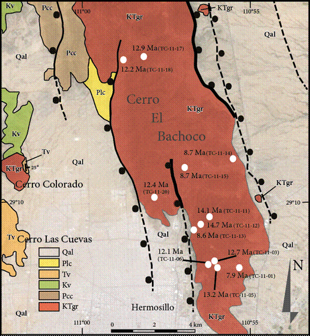
Figure 2 Geological sketch map of Hermosillo and Cerro Bachoco area. AFT ages are shown with white dots. KTgr: Cretaceous and Paleogene granite and granodiorite; Pcc: Paleozoic limestone and quartzite; Kv: Cretaceous volcanic rocks (mainly andesite); Tv: (Tertiary volcanic rocks (mainly Late Miocene peralkaline ignimbrite); Plc: Pliocene (?) conglomerate; Qal: Quaternary alluvium.
Sierra La Madera
The Sierra La Madera is located at the longitude 109°30', and constitutes a large pluton of ~450 km2 (Figure 3). The Sierra La Madera (previously named Sierra Oposura) consists mainly of porphyritic granite, quartz monzonite and granodiorite and some associated mafic xenolithes (Roldán-Quintana, 1994). Two reported sericite and biotite K-Ar ages are available for the granodiorite with 59.6 ± 1.3 and 62.7 ± 1.4 Ma, respectively (Damon et al., 1983). The pre-intrusive rocks crop out to the south of the pluton and consist of a Lower Cretaceous sedimentary rocks probably belonging to the Barremian to Albian Lampazos sequence described 50 kilometers to the south (Scott and González-León, 1991), and Upper Cretaceous volcanic rocks of the Tarahumara Formation (Wilson and Rocha, 1949). To the east, the Tarahumara Formation is overlain by Cenozoic felsic volcanic rocks, which belong to the Sierra Madre Occidental volcanism, and by the Baucarit Formation. Southwest of the Sierra La Madera, the Moctezuma valley is covered with Quaternary basaltic flows.
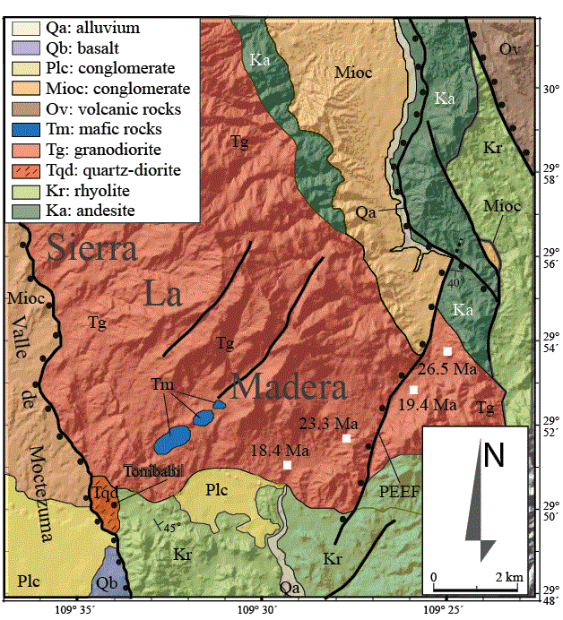
Figure 3 Geological sketch map of Sierra La Madera. AFT ages are shown with white squares. Ka: Cretaceous andesite of the Tarahumara Formation; Kr: Cretaceous rhyolite, tuffs, volcanic breccia, ignimbrite of the Tarahumara Formation; Tgr: Paleogene granite and granodiorite; Tqd: Tonibabi quartz-diorite; Tm: Gabbro xenoliths; Ov: Volcanic rocks; Mioc: Báucarit Formation; Plc: Pliocene conglomerate; Qb: Quaternary basalt; Qa: alluvium. PEEF: Puerto El Encino fault.
SAMPLING AND FISSION-TRACK PROCEDURES
Commonly, in extensional settings, the sampling of granitic rocks for fission track dating is performed in the footwall of low-angle normal faults, parallel to the regional direction of extension in order to determine the timing and rate of slip along main normal faults (e.g., Fitzgerald et al., 1991; Miller et al., 1999; Colgan et al., 2006). Even if the fault traces are buried, the preserved Basin and Range morphology permits to infer the approximate fault position. Assuming a progressive tilting of the footwall and hanging wall during extension, the timing of exhumation and cooling of the footwall can be calculated based on the relationship between the AFT ages of samples and their distanceelevation from the normal fault.
After crushing, pulverizing and sieving the samples, apatite grains were separated using a Gemini separation table for heavy minerals, magnetic separation techniques, and finally standard heavy-liquids (sodium polytungstate and methylene iodide). Apatite aliquots were mounted in epoxy resin and then polished with sand paper, diamond paste and aluminum powder in progressive steps, in order to expose the crystal surfaces and generate a flat surface. The quality of the polished surfaces was controlled with a reflected light optical microscope. After polishing, the grain mounts were cleaned in an ultrasonic bath and subsequently etched with 5.5M HNO3 for 20 seconds at 21 °C. Samples were covered with muscovite sheets as external detectors and sent for thermal neutron irradiation in the well-thermalized FRM II Research Reactor at the Technische Universität München, Germany. The apatite samples were irradiated together with IRMM 540R dosimeter glasses (15 ppm uranium) and Durango and Fish Canyon Tuff age standards. A set of 11 sub-samples was prepared for track length measurements and was irradiated with a 252Cf source at the University of Melbourne fission-track laboratory. Samples and standards were analyzed dry at 1,250× magnification for age determination and track lengths measurements, using an Olympus BX51 optical microscope with transmitted and reflected light and the FTStage 4.04 system of Dumitru (1993).
Fission-track studies were performed on 15 granitic samples, 11 from Cerro Bachoco and 4 from Sierra La Madera (Table 1). AFT ages were calculated with the BINOMFIT program of M. Brandon (see Ehlers et al., 2005). Time-temperature histories were modeled using the HeFTy 1.8 software of R. Ketcham (e.g. see Ketcham, 2005). In this paper, we assume a mean surface temperature of 25±10 °C for the determination of paleodepths of the partial annealing zone and modeling of thermal histories. The models presented in Figures 4 and 5 show a temperature range from 0 to 140 °C, nevertheless the time-Temperature paths are only well constrained at temperatures from ~60 to 110 °C, also known as the partial annealing zone (PAZ). In the PAZ, fission tracks experience shortening, which depends on residence time of the sample at this temperature, and also on the chemical apatite composition. For the presented thermal models, the mean fission-track etch pit diameter parallel to the crystallographic c-axis for each apatite grain (Dpar) was used as a kinetic indicator for chemical compositional effects. Below 60 °C fission tracks are more stable but shortening may occur under special conditions. Annealing kinetics below this temperature is poorly understood.
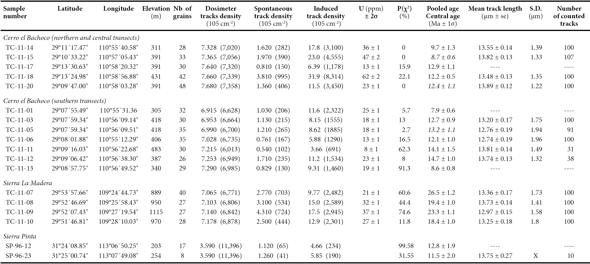
Table 1 Comparative results of AFT ages for samples TC-11-01 and TC-11 03 made in the Thermochronology Laboratory of ISTerre (Gre), and the Fission Track Laboratory of ERNO (Hmo). Sample TC-11-01 was dated four times by two analysts (A1 and A2), one in ISTerre and three in ERNO. TC-11-03 was dated three times by the same analyst (A1). Gre: Grenoble; Hmo: Hermosillo.
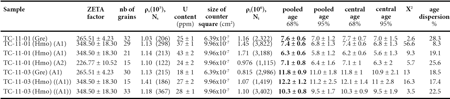
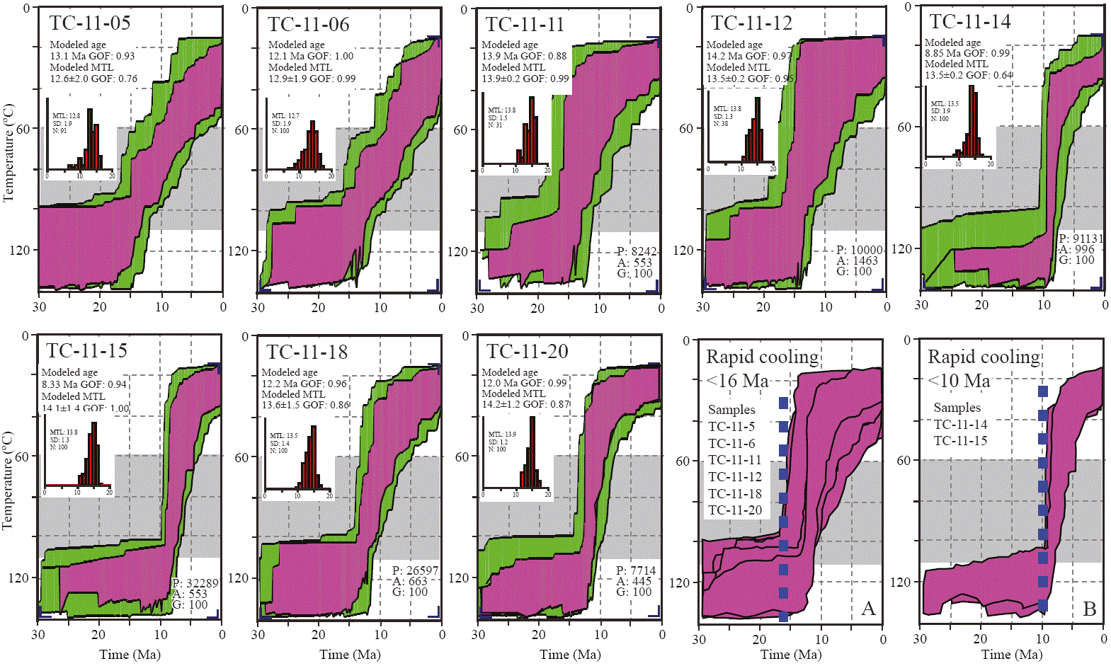
Figure 4 AFT thermal history modelling for Cerro Bachoco samples. Models were generated by the HeFTy software v. 1.8.3.68 (Ketcham,,2005). A) Compiled good paths for samples with cooling starting at ~16 Ma. B) Good paths for the samples with rapid cooling younger than 10 Ma. In each model the mean track length (MTL) is presented, goodness of fit (GOF), paths tried (P), acceptable paths (A) with a GOF>0.05 and good paths (G) with a GOF>0.5. Corners portions of each constraint box are presented in purple color.
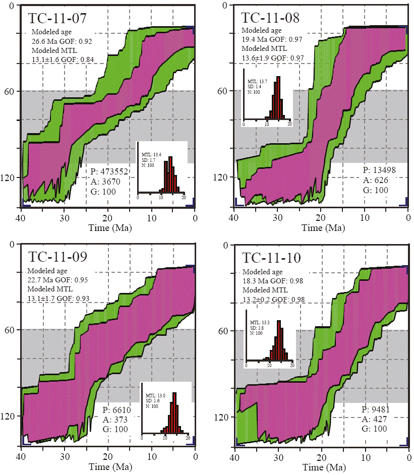
Figure 5 AFT thermal history modelling for Sierra Madera samples. See figure 4 for details. Thermal history reconstructions for samples from the southern portion of Sierra La Madera suggest relatively fast cooling from ~25 to ~12 Ma at cooling rates of ~4-8 °C/Ma.
In order to calibrate the fission-track laboratory of the Estación Regional del Noroeste (ERNO), Instituto de Geología, Universidad Nacional Autónoma de México (UNAM), two samples of the Cerro Bachoco were dated in the thermochronology laboratory of the ISTerre at the University Joseph Fourier in Grenoble, France, and in the ERNO fission track laboratory. Both laboratories use the same methodology, i.e. the external detector method, as well as the same equipment for fission track counting: the automatic Kinetek stage, a Calcomp digitizing tablet, an Olympus microscope BX51, and the same three softwares for determining the neutron fluence, the zeta factor, and the age of cooling of apatite crystals. Standards of Durango and Fish Canyon Tuff apatites were used for the calculation of the Zeta calibration factor.
As an example, the sample TC-11-01 collected at Hermosillo has been dated by one analyst at ISTerre and by two analysts at UNAM. The pooled ages of the four age determinations are in close agreement: 7.6 ± 0.6, 7.4 ± 0.6, 7.1 ± 0.8 and 7.1 ± 0.7 Ma (Table 1).
RESULTS
Cerro Bachoco
Eleven samples were collected between an elevation of 305 and 483 m along four NE-SW and E-W transects perpendicular to the range (Figure 2). They yielded AFT ages between 14.7 ± 1.1 and 7.9 ± 0.6 Ma (Table 2).
Table 2 Table of AFT ages results. Zeta values; ρ and N: Fossil (f) and induced (i) track densities and number of fossil (f) and induced (i) tracks counted; P (X2) Probability of obtaining a X2 value for v degrees of freedom, with v = number of counted grains 1; ρd and Nd: track density for the fluence glass monitors and number of tracks counted; SD: Standard deviation of the confined track length distribution. Coordinates are in Universal Transverse Mercator system. In the case of the P (X2) failed with values < 5%, the central age is used, instead of the pooled age. The central ages are in italic in the table. The Zeta value used for TC-11-01 is 226.77 ± 10.52. For the others samples, the Zeta value is 265.51 ± 4.23. X: No data available.
Northern transect and Central transect
Both samples collected in the northernmost part of the Cerro Bachoco (TC-11-17 and TC-11-18) yielded close AFT ages (12.9 ± 1.1 and 12.2 ± 0.5 Ma). For the sample TC-11-18, the mean track length (MTL) is 13.48 ± 0.13 μm with a standard deviation (SD) of 1.36.
In the central part, three samples were collected (TC-11-14, TC-11-15 and TC-11-20). The AFT ages are from east to west 9.7± 1.3 (TC-11-14), 8.7 ± 0.6 (TC-11-15), and 12.4 ± 1.1 Ma (TC-11-20). MTL are respectively 13.55 ± 0.14 μm (SD = 1.39), 13.82 ± 0.13 μm (SD = 1.33) and 13.89 ± 0.12 μm (SD = 1.21). AFT thermal modeling for these three samples suggests relatively rapid cooling within the partial annealing zone (PAZ) at the time corresponding to the AFT age.
Southern transects
In the southern part, samples are distributed along two profiles. Samples of the northernmost transect yielded the following results from east to west: 14.1 ± 1.5 Ma (TC-11-11), 14.7 ± 1.0 Ma (TC-11-12) and 8.6 ± 0.8 Ma (TC-11-13). MTL are respectively 13.81 ± 0.14 μm (SD = 1.46), 13.74 ± 0.13 μm (SD = 1.30) for samples TC-11-11 and TC-11-12. Four samples were collected along the southernmost section. From east to west, AFT ages are as follows: 7.9 ± 0.6 Ma (TC-11-01), 12.7 ± 0.9 Ma (TC-11-03), 13.2 ± 1.1 Ma (TC-11-05) and 12.1 ± 1.0 Ma (TC-11-06). MTL are 13.20 ± 0.17 μm (SD = 1.75) for TC-11-03, 12.76 ± 0.19 μm (SD = 1.93) for TC-11-05, and 12.74 ± 0.19 μm (SD = 1.93) for TC-11-06.
Interpretation of Cerro Bachoco results
The AFT ages from the intrusive rocks of the Bachoco area suggest that cooling within the PAZ for the Laramide igneous basement in central Sonora is coeval with the age of initial continental rifting at ~12 Ma, which preceded the Late Miocene-Pliocene opening of the Gulf of California. Furthermore, the mean track lengths and their unimodal distribution show that rapid cooling occurred within the PAZ between 14 and 8 Ma, and a cooling history associated with Basin and Range extension in the Sierra Bachoco can be excluded at least at AFT sensitive temperatures. In other words, the Basin and Range extension did not allow the exhumation of the present topographic surface of the Sierra Bachoco at depths shallower than the partial annealing zone. The present heat flow in Hermosillo is 94.3 mW/m2 and the reduced heat flow is 81.3 mW/m2, which is similar to higher values of the Basin and Range province (Smith, 1974). The geothermal gradient near Hermosillo obtained from heat flow data is 32.78 ± 0.17 °C/km, which is like an average continental value. If we assume a higher value than the present one, as for example a reasonable value of ~35 °C/km during continental rifting and break-up of the Gulf of California, and a surface temperature of 25 °C, we can estimate a paleodepth interval for the apatite partial annealing zone between ~1 and ~2.4 km.
On the contrary, the granite of the Cerro Colorado, which is located 6 km west of Cerro Bachoco, is overlain by 12.5 Ma old ignimbritic flow (Vidal-Solano et al., 2005), suggesting that exhumation occurred before the middle Miocene, which is therefore likely related to Basin and Range extension. The proximity of the Cerro Colorado and Cerro Bachoco suggests that both ranges correspond respectively to the hanging wall and footwall of a normal fault, located along the western limit of the Cerro Bachoco.
Sierra La Madera
The four samples of the Sierra La Madera were collected along the NE-SW oriented cross-section between Moctezuma and Huásabas (Figure 3). The samples have nearly identical elevations, comprised between 889 and 1115 m. The AFT ages range between 26.5 and 18.4 Ma. From NE to SW the AFT ages are (Table 2): 26.5 ± 1.2 Ma (TC11-07); 19.4 ± 1.0 Ma (TC-11-08); 23.3 ± 1.1 Ma (TC-11-09), and 18.4 ± 1.0 Ma (TC-11-10). MTL are 13.26 ± 0.17 μm (SD = 1.75) for sample TC-11-07, 13.73 ± 0.14 μm (SD = 1.40) for sample TC-11-08, 12.97± 0.15 μm (SD = 1.57) for sample TC-11-09, and 13.25 0.18 μm (SD = 1.80) for sample TC-11-10. We interpret these results as cooling ages related with the exhumation of La Madera pluton during Basin and Range extension, coupled with the erosion of the thick (more than 1,500 m) overlying volcanic sequence of the Sierra Madre Occidental along its western escarpment. The samples can be grouped in two pairs of AFT ages: The southwestern samples TC-11-09 and TC-11-10, and the northeastern samples TC-11-07 and TC-11-08. Both pairs display the same distribution of AFT ages, the oldest one to the east and the youngest one to the west. This offset may be explained by the presence of the Puerto El Encino fault (Figure 3). The good correlation between the horizontal distance between both samples of each pair and their AFT age offset strongly supports that the four samples share a contemporaneous cooling history (Figure 5).
These AFT ages are in good agreement with the AFT ages in apatite obtained along the western flank of the Sierra La Madera (Lugo-Zazueta, 2013). These ages comprised between 11.1 ± 1.1 and 22.2 ± 4.3 Ma show a good correlation between elevation and AFT ages, suggesting a progressive cooling of the footwall of the normal fault between 22 and 11 Ma (Lugo-Zazueta, 2013).
Thermal history reconstructions
For most of the analyzed samples, time-Temperature modeling was carried out to determine the cooling rate of the samples and therefore for the region they were collected (Figures 4 and 5). Models were generated with the HeFTy software v. 1.8.3.68 (Ketcham, 2005). Thermal history reconstructions are generated by a Monte Carlo simulation of the apatite fission track age and confined track length data (Ketcham et al., 2007). Annealing behavior of track lengths under lab conditions were extrapolated to geological time in order to reconstruct the thermal conditions that prevailed for generating the measured track lengths (Ketcham et al., 2007). For the time-Temperature path reconstructions an inverse modeling approach was used, using constraints that allowed the software to explore paths in a wide range of time and temperature, since no geological units are present to restrict the modeling time. Fission tracks are sensitive to temperature changes between ~60 and ~110 °C. The presented models are also well constrained within that temperature range, even though figures show temperatures from 0 to 140 °C.
Thermal history reconstructions for samples from the southern portion of Sierra La Madera suggest moderately rapid cooling from ~25 to ~12 Ma at cooling rates of ~4-8 °C/Ma. From the Cerro Bachoco and surrounding regions the thermal reconstructions suggest a younger episode of relatively rapid cooling which initiates from ~12 until ~8 Ma at faster cooling rates of ~10-15 °C/Ma. Cooling history for this region is slightly more rapid than in Sierra La Madera, at least at AFT partial annealing zone temperatures. The t-T models suggest that the exhumation in the Cerro Bachoco occurred at the approximately double rate than in the Sierra La Madera.
DISCUSSION
This study was conducted in granitic rocks of two plutonic belts, characterized by the Basin and Range morphology. The 50-120 km wide central belt, which includes the batholith of Hermosillo and the huge Aconchi batholith in central Sonora, between the Hermosillo and Moctezuma areas (Figure 1), is the largest one in the southern Basin and Range province and consists mostly of granite and granodiorite. The eastern belt contains a few numbers of plutons almost exclusively consisting of granodiorite, including the pluton of Sierra La Madera. The western belt, which is not included in this work, is located along the coast of Sonora and in the Tiburón Island, and has been the focus of previous thermochronological works (Calmus et al., 1998; Calmus et al., 2000; Kohn et al., 2003; Lugo-Zazueta, 2013).
In order to allow comparison with the thermal evolution of the western belt, we included two additional AFT ages obtained for Laramide granitic samples of the Sierra Pinta, which is located in northwestern Sonora (Figure 1), where the N-S morphologic pattern of the Basin and Range is replaced by a NNW-SSE one, parallel to the Gulf direction. The Sierra Pinta area belongs to the coastal domain of Stewart and Roldán-Quintana (1994), which presumably corresponds to the Gulf extensional domain. AFT ages of the Sierra Pinta indicate a Middle Miocene cooling for the Cenozoic plutonic rocks: 12.8 ± 1.9 and 11.5 ± 2.0 Ma (Table 2). The mean track length of 13.75 ± 0.86 mm for a pegmatitic sample suggests that it passed relatively rapidly through the partial annealing zone prior to 12 Ma. This age is coeval with the age of the volcanic sequence, which unconformibly overlies plutonic rocks east of the Sierra Pinta, based on the correlation with alkalic to tholeiitic volcanism of the Pinacate area (Vidal-Solano et al., 2000), and may be related to the first pulse of continental break-up, previous to the opening of the Gulf.
The four youngest AFT ages (<10 Ma) that we previously obtained from Sonora are located along the coast of the Gulf, and within the Hermosillo graben (Calmus et al., 2000). South of Puerto Libertad, the Punta Cirios granodiorite yielded an AFT age of 6.7 ± 0.5 Ma, and the granodiorite of Bahía Kino an age of 5.9 ± 0.4 Ma. Between Bahía Kino and Punta Chueca, a granodiorite of similar modal composition and texture yielded an AFT age of 15.1 ± 3.4 Ma (Calmus et al., 2000). The structure of the area is poorly constrained and the geometric relation between both samples is still unknown. Such discrepancies of AFT ages indicate that tectonic unroofing may be heterogeneous within a relatively small area, and is possibly related to block tilting. In the Bahía Kino region, tilted volcanic rocks, as young as 12.3 Ma, were reported by Gastil et al. (1979). The thickest tuffaceous deposits are correlated (Oskin et al., 2001) with the 12.6 Ma old San Felipe Tuff (Stock, 1989; Stock et al., 1999). The age of tilting is well constrained, between 11.5 and 7 Ma (Bennett et al., 2013), before the dextral strike-slip faulting that dismembered the previous tilted structures.
The AFT ages of Cerro Bachoco suggest that relatively rapid cooling is related to Late Miocene to Pliocene activity of the whole extensional structure from Hermosillo to the coast of Sonora, near Empalme. The Empalme graben formed a continuation of the Guaymas pullapart basin before the opening of the Gulf of California (Lonsdale, 1989), and before the basin became an oceanic spreading center at 2.4 Ma (Lonsdale, 1985). The modern Hermosillo and Empalme grabens (here, Empalme-Hermosillo graben) correspond to the Pliocene reactivation of a Basin and Range graben structure during the opening of the Gulf. The north-south direction of this previous Basin and Range structure is closely parallel to the direction of the Guaymas basin, which is one of the en échelons pull apart basins along the transform fault system of the Gulf of California. An AFT age of 13.9 ± 1.1 Ma (Calmus et al., 1998) of the granite located north of the central part of the Empalme basin is intermediate between Basin and Range and Gulf of California rifting, and may represent a tilted block within the graben. The granophyre (granitoid El Papalote of Mora-Alvarez and McDowell, 2000) sampled south of Empalme yielded an AFT age of 10.8 ± 1.0 (Calmus et al., 1998), which is consistent with K/Ar ages of 12.08 ± 0.36 and 11.74 ± 0.35 Ma, on K-feldspar and whole rock respectively (Paz-Moreno, 1992). The 2 Ma gap between K/Ar and AFT ages points to rapid cooling, which is common for this type of shallow intrusions. The N-S distribution of this granophyre, which extends 60 km to the north along the eastern flank of Guaymas and La Ventana ranges, shows a close relationship with the graben structure (Cochemé, 1985), but the age, younger than the typical Late OligoceneMiocene Basin and Range magmatism, suggests that the emplacement of the granophyre and associated ignimbrites (La Ventana tuff of Mora-Alvarez and McDowell, 2000) is related to rifting of the Gulf of California starting at ~12 Ma.
AFT ages of the southeastern part of Sierra La Madera are similar to AFT ages obtained previously in other areas of eastern Sonora. The granodiorite of Santa Rosa yielded an AFT age of 28.4 ± 0.9 Ma (Calmus et al., 1998), which is compatible with cooling implied by K-feldspar Ar-Ar geochronology indicating slow cooling from 300 °C at 50 Ma to 190 °C at 30 Ma suggested by Gans (1997). The AFT age suggests rapid cooling between 30 and 28 Ma, associated with tectonic denudation, a little older than the age of unroofing proposed by Gans (1997), based on structural and sedimentological observations in syntectonic continental deposits, or on the basis of the 27 Ma old mafic lava flow at the base of the Báucarit Formation in the Rio Yaqui basin. In central Sonora, two different ages were obtained from the Potrero de Galindo pluton, 23.9 ± 0.7 Ma to the west, and 18.4 ± 0.7 Ma near the central part of the pluton (Calmus et al., 1998). The mean track-length from the central locality is 12.08 μm with a standard deviation of 2.42 μm. This discrepancy can be interpreted as a consequence of tilting of the pluton to the east. AFT ages of this transect are progressively younger from east to west. Nevertheless, we observe that AFT ages in the western part of the Sierra La Madera are decreasing as they approach the fault, which separates the footwall of the Sierra La Madera from the hanging wall, which is the Moctezuma graben (Lugo-Zazueta, 2013).
In Baja California Peninsula, the Main Gulf Escarpment represents a Miocene faulted boundary (Dokka and Merriam, 1982). No evidence of Basin and Range extension is present west to this structure. In the Loreto area, the escarpment corresponds to an erosional front of the Comondú volcanic pile. The faulted limit between Cretaceous batholith and Pliocene sediments of the Loreto basin is located downslope. The exhumation along the escarpment which limits the Sierra San Pedro Mártir to the east was not sufficient to exhume rocks located below the partial annealing zone for fission-tracks in apatite, i.e. below 2.4 km for a geothermal gradient of 35 °C/km, before rupturing of the crust along the Gulf of California extensional province. This result, in addition to previous data from the Sierra San Pedro Mártir pluton (Ortega-Rivera et al., 1997), suggests that in this area the Main Gulf Escarpment corresponds more to the morphologic expression of subsidence of the eastern block, than to an uplift of the western one (Seiler et al., 2011). Along the eastern margin of the Los Cabos block, southern Baja California, Late Miocene AFT ages (Fletcher et al., 2000) may indicate that part of the exhumation corresponds mainly to unroofing related to an eastern displacement along the San José de Los Cabos fault.
CONCLUSIONS
Despite of the great variability of emplacement ages of the Laramide magmatic arc across Sonora from 90 to 45 Ma, AFT results show that cooling of plutons is mainly controlled by the Cenozoic Basin and Range extension and the opening of the Gulf of California. The AFT ages presented in this work and already published AFT ages show an Oligocene to Late Miocene decreasing in age from east to west, suggesting a progression in time of the exhumation to the west. That distribution may be roughly correlated with the thinning of the crust also from west to east (Figure 6). Ongoing AFT studies will provide more information to elucidate this evolution in time, the relationship with the crust thickness, and also the kinematics of deformation in the region. This study shows evidence that the region displays different extensional histories, and possibly an overlap in time and space between the eastern boundary of the Gulf of California extensional province and the western boundary of the Basin and Range extensional province.
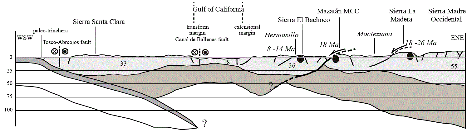
Figure 6 WSW-ENE cross-section showing the variation of the crust thickness between the Baja California western margin and the Sierra Madre Occidental. The crust thickness is taken from Romo et al. (2001) for the Baja California Peninsula, Lizarralde et al. (2007) for the Gulf of California, López-Pineda (2007) for the Basin and Range province in Sonora, and Bonner and Herrin (1999) for the Sierra Madre Occidental. The lithospheric mantle thickness is speculative. Black dots indicate the samples location for the Cerro Bachoco (this study), the Mazatán metamorphic core complex (Vega-Granillo and Calmus, 2003), and the Sierra La Madera (this study). We observe that AFT get younger from Sierra Madre Occidental to the Gulf Extensional Province, suggesting a diachronic cooling at low temperature during Miocene Basin and Range extension and Late-Miocene-Pliocene rifting of the Gulf of California. It is assumed that an asthenospheric window exists below the Baja California and Sonora regions (Calmus et al., 2011b), due to the rupture between slabs of the Farallon and Magdalena-Guadalupe plates.
The present study is one of the first attempts based on apatite fission-track analysis to better constrain the evolution of structures and the tectonic schedule within the extensional province of northwestern Mexico. Results yielded new findings on the thermal behavior of plutons during Cenozoic extension and in some cases also for Late Cretaceous time. This large geographic distribution allowed enlightening some of the thermo-tectonic problems related with extensional tectonics of northwestern Mexico, which can be useful for future detailed studies.
AFT ages in Sonora range from 36 to 6 Ma. In contrast with Baja California, no Cretaceous to middle Eocene AFT ages have been reported. This apparent heterogeneity is due to 1) the original position and depth of each plutonic body before Cenozoic extension; 2) the diachronous response of Sonoran plutons to unroofing and erosion, and 3) the footwall geometry particularly when it is related with lowangle normal faults.
AFT results from plutons of Baja California Peninsula and Sonora suggest a distinct thermotectonic evolution for both groups. Plutons from Baja California belong to the Alisitos magmatic arc, and have experienced cooling probably related to the collision of this arc with the continent. Plutons of Sonora are younger than those of Baja California, and are classically associated with a change in the direction of motion of the North America plate (Coney, 1972), or with a change in the dip of the subducting slab, which is proposed to explain the Laramide orogeny in the western United-States (Dickinson and Snyder, 1978). These younger Laramide plutons remained stable until Basin and Range extension started, during which they were tilted and exhumed.

