


 text new page (beta)
 English (pdf)
 Article in xml format
 Article references
 Send this article by e-mail
 Cited by SciELO
  Similars in
SciELO
Similars in
SciELO 
 Permalink
INTRODUCTION
Seismites are soft-sediment features produced by paleoearthquakes. These are formed after sediment deposition, before sediment compaction, and during the sudden breakdown of a loosely packed, water-saturated grain framework with low to zero shear resistance as a result of tectonic and sedimentary processes (Rossetti and Santos, 2003; Alfaro et al., 2002; Perucca et al., 2009; Moretti and Ronchi, 2011). The term "seismites" proposed by Seilacher (1969), is commonly used in the literature to describe deformation of unconsolidated sediments caused by earthquakes (Mills, 1983; Maltman, 1984; Collinson, 2003). Soft-sediment deformation structures are very important in paleogeographic reconstruction, as they indicate seismic activity, and are also essential components in the analysis of the conditions affecting the deposition of sediments (Sims, 1975; Allen, 1982; Mills, 1983; Seth et al., 1990). However, their origin is still questioned because the same or similar structures can be produced by non-seismic processes (autokinetic triggering mechanisms): storm waves, gravitational or rapid sediment accumulation, cyclic loading from vortices, flow conditions approaching the plane-bed phase, flood surges, flash floods, or from frictional drag of saturated sand (Selley, 1969; Hendry and Stauffer, 1975; Lowe, 1975; Owen, 1987; Wells et al., 1993; Le Heron and Etienne, 2005; Santos et al., 2012). To help understand whether soft-sediment deformation structures are sedimentation controlled or seismically induced (allokinetic triggering mechanisms), a combination of various field criteria, including water escape features, hydroplastic deformation, liquefaction and fluidization features, and seismic activity related to episodic fault motions, normally of magnitude 5 or greater, is described by different authors (Sims, 1975; Obermeier, 1996; Jones and Omoto, 2000; Moretti and Ronchi, 2011; Kundu et al., 2011; Santos et al., 2012). Soft-sediment deformation structures have been attributed to porepressure changes, mainly caused by fluid escape during fluidization and liquefaction (Lowe, 1975; Owen, 1987). Liquefaction features are mentioned as the most common type of soft-sediment deformation related to earthquakes (Allen, 1977; Obermeier, 1996). This liquefaction can be induced by different triggering agents (earthquakes, overloading and storm waves, among others). Earthquake-induced structures represent different sedimentary responses to seismic shaking and depend on several interrelated factors (e.g., lithology, consolidation, saturation, depth, seismic magnitude and epicentral distance). This work presents the first report of a suite of soft-sediment deformation structures in fluvial deposits of Eocene-Oligocene age, which accumulated in a sedimentary basin located in the Sierra de Guanajuato (Figure 1). The aim of this paper is to document the nature and distribution of the deformation structures preserved in the Losero Formation, to discuss the processes responsible for their genesis and analyze the possible influence of paleoseismic events as the triggering mechanism for sediment deformation.
GEOLOGICAL SETTING
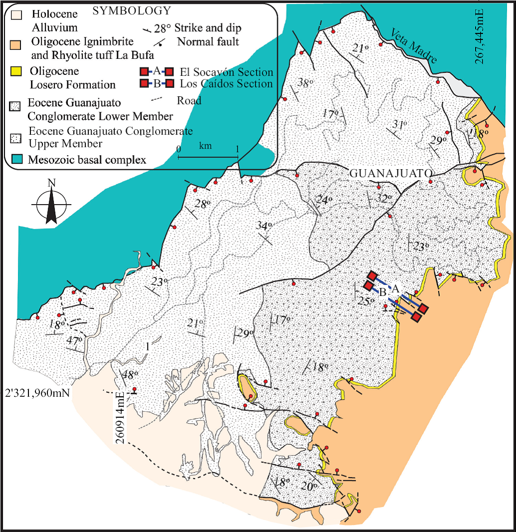
The Sierra de Guanajuato, located in southern part of the Mesa Central, represents a transition zone between the Sierra Madre Occidental (SMO) and the Mexican Volcanic Belt (MVB) volcanic provinces (Randall et al., 1994) . The SMO consists mainly of silicic ignimbrites and rhyolitic lava domes of Oligocene and Miocene ages (Nieto-Samaniego, 1992; Ferrari et al., 1999). The MVB units are basalts and andesites of middle Miocene to late Pliocene ages (Hasenaka et al., 1994; Valdez-Moreno et al., 1999). The successions of the Sierra Madre Occidental (SMO) and the Mexican Volcanic Belt (MVB) overlie metamorphic and sedimentary rocks of Mesozoic age (Echegoyen-Sánchez et al., 1970; Dávila-Alcocer and Martínez-Reyes, 1987; Martini et al., 2013). Lapierre et al. (1992) and Ortiz Hernández et al. (1992) recognized two Mesozoic petrotectonic assemblages in the Sierra de Guanajuato (intrusive complex and eruptive sequence assemblage and Guanajuato arc assemblage). A succession of Cenozoic red beds (Guanajuato Conglomerate and Losero Formation) overlies the Mesozoic assemblages. The sedimentary Cenozoic succession was deposited in an extensional tectonic setting, represented by synvolcanic conjugated sets of normal faults. The Guanajuato conglomerate presents a thickness between 1500 and 2000 m and was divided by Edwards (1955) into two members. The lower member has a thickness between 900 and 1300 m, unconformably overlies the Mesozoic assemblage, and is considered of Eocene age (Ferrusquia-Villafranca, 1987; Aranda-Gómez and McDowell, 1998). The upper member has a thickness that varies from 170 to 700 m, increasing toward the southeast, consisting of a matrix-supported conglomerate. The Losero Formation has been considered as the base of the Oligocene volcanic cover, overlying the Guanajuato conglomerate, and has been previously described by a number of geologists (e.g., Orozco, 1921; Guiza, 1949; Schulze, 1953; Edwards, 1955; Echegoyen-Sánchez et al. 1970; Aranda-Gómez, et al. 1989; Randall et al.1994; Aranda-Gómez and Mc Dowell, 1998; Aranda-Gómez et al. 2003, Puy-Alquiza et al., 2014). The Losero Formation consists of brown and green fine to coarse-grained sandstones intercalated with mudstones, accumulated in a fluvial environment by predominantly turbulent flow and it represents the distal facies of the Guanajuato conglomerate (Puy-Alquiza et al., 2014). The possibility that these deposits are related to volcanic activity is not discarded considering that some lithofacies contain volcaniclastic material derived from the redeposition of the products of volcanic activity.
STRATIGRAPHY OF PALEOGENE SUCCESSIONS OF THE LOSERO FORMATION
The Losero Formation consists of clastic rocks dominated by sandstones and mudstone, with internal erosional surfaces. The succession is dominated by sets with plane-parallel bedding alternating with laterally-extensive sets with cross-stratification. Recognized lithofacies and depositional architectural elements are presented in Tables 1, 2 and 3. The formation has been divided into two informal members (Puy-Alquiza et al., 2014) (Figure 2). The lower member, about 5 m thick, rests on a surface of Eocene conglomerate (Guanajuato Conglomerate Formation). The most distinctive lithological feature of this member is a coarse- to fine-grained sandstone intercalated with brown mudstone deposits. The upper member rests conformably on the lower member, and is characterized by a 25 m thick brownish red and green sandstone intercalated with mudstone.
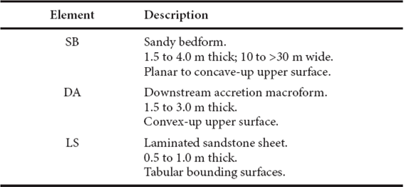
Table 2 Sedimentary facies associated with soft-sediment deformation structures in the lower member of the Losero Formation.
| Sedimentary facies | Description | Interpretation |
|---|---|---|
| Coarse-grained sandstone with normal gradation (facies Sg). | Brownish red sandstone, with normal gradation. Massive medium- to coarse-grained sandstone. | Scour fill. |
| Medium- to fine-grained sandstone with plane-parallel laminae (facies Sh). | Brownish red, medium- to fine-grained sandstone with planeparallel laminae. Thickness of individual laminae sets range from 0.1 to 0.5 m. Some sets of laminae show undulations and small cusps indicative of syn-sedimentary deformation, probably induced by water escaping during deposition. | Evidence of tractive flow in upper flow regime (Harms, 1979). |
| Medium-grained sandstone with cross lamination (facies St). | Green medium-grained sandstone with cross lamination. The majority of the sets have a very low angle and seem to be a laterally extensive combination of trough and tabular types. Thickness of individual cross bed sets ranges from 0.2 to 0.5 m. The inclination of sets vary from 5 to 15 degrees and are oriented invariably towards the SE. | Sinuous-crested and linguoid (3-D) dunes. |
| Medium- to fine-grained sandstone with cuspate ripple marks (facies So). | Brownish red, medium- to fine-grained sandstone with cuspate ripple marks These ripples present a curved geometry and are discontinuous. They additionally have high amplitude, tuning fork patterns and 10 cm distance from crest to crest with an orientation towards the SE. | These ripple types are commonly formed by moderate currents within a lower flow regimen (Harms, 1969). They are suggestive of fluvial environments (channels or channel bars) and are most abundant along the lower reaches of streams where they are associated with parting lineations. They are also abundant at the distal ends of ephemeral streams (Picard and High, 1973). |
| Mudstone with desiccation cracks (facies Fm). | The mud beds show desiccation cracks of different sizes (1 to 6 cm), where the larger cracks truncate the smaller ones. | Massive, desiccation cracks. |
Table 3 Sedimentary facies associated with soft-sediment deformation structures in the upper member of the Losero Formation.
| Sedimentary facies | Description | Interpretation |
|---|---|---|
| Coarse-grained sandstone withnormal gradation (facies Sg). | Brownish red and green sandstone. Massive medium- to coarse-grained. | Scour fill. |
| Medium- to fine-grained sandstone with plane-parallel laminae (facies Sh). | Brownish red medium- to fine-grained sandstone with planeparallel laminae. Thickness of individual laminae sets range from 0.5 to 3 cm. Some sets of laminae show undulations and small cusps indicative of syn-sedimentary deformation, probably induced by water escaping during deposition. | Evidence of tractive flow in upper flow regime (Harms, 1979). |
| Medium-grained sandstone with cross lamination (facies St). | The cross-bedded unit contains solitary, isolated trough sets. The sets inclinations vary from 5 to 15 degrees and are oriented invariably towards the SE. Thickness of individual cross bed sets range from 0.5 to 1 cm. The trough sets are cut into older, planar laminated sandstone. | Sinuous-crested and linguoid (3-D) dunes. |
| Medium-grained sandstone with groove and flute casts, and antidunes (facies Sgf). | The flutes and groove casts only occupy the bottom part of the bed. Flute casts are aligned in rows parallel to the flow. Bluntnosed cylindrical forms are associated with more pointed and conical forms. They are approximately equal in size and are aligned more or less parallel to each other. The length of the flutes varies from 19 to 22 cm with an orientation of 35° SE. The groove casts are associated with the flute casts, these are about a millimeter or so in height and 2 to 4 cm in length, and they present an orientation of 45° towards the SE. They are remarkably straight and some of them are continuously exposed along all the exposed bedding plane. The antidunes show a sinusoidal appearance and their amplitudes reach 1 to 2 cm. | The flute casts are erosive structures that are produced by the movement of a fluid over a cohesive substrate and are caused by erosion of freshly deposited mud on an underwater slope (turbidity current) (Ricci-Lucchi, 1995). The groove casts are produced by flow of currents on soft mud (Crowell, 1955; McBride, 1962).The antidunes are characteristic of supercritical and subcritical flow conditions (Nuñez-González and Vide, 2010). These are also characteristic products generated under upper flow regime (Gilbert, 1914). |
| Medium- to fine-grained sandstone with ripple marks (facies So). | Ripples are asymmetrical, have low amplitude, pointed crests and rounded troughs. They have 1-2 cm crest distance and their orientation is 65° SE. The ripples are present above the flutes and groove casts. | Formed by ripple migration in extremely shallow water, <2 m deep, under flow conditions (Tanner, 1967, 1971; Aspler et al., 1994). |
| Mudstone with desiccation cracks (facies Fm). | The mud beds show desiccation cracks of different sizes (1 to 6 cm) where the larger cracks truncate the smaller ones. | Overbank, abandoned channel or drape deposits. |
| Medium- to fine-grained sandstone with seismites (facies Sd). | Green medium- to fine-grained sandstone with soft-sediment deformation structures (asymmetric folds, pseudonodules, sandstone dikes, flame structures, non-sedimentary normal faults and convolute laminae). | Hydroplastic deformation, fluidization and liquefaction were the three main mechanisms related to sediment deformation. |
The lower member
According to Puy-Alquiza et al. (2014), the lower member is characterized by lithofacies such as: Sg (coarse sandstone of brown color with normal gradation), Sh (medium to fine sandstone with plane-parallel laminae, and associated desiccation cracks), St (medium sandstone with cross lamination), Fm (mudstone with desiccation cracks), and So (medium to fine sandstone with cuspate ripple marks). The primary sedimentary structures found mainly in the lower member are: plane parallel laminae, desiccation cracks, ripples, and cross-beds (Table 2). The preserved fluvial architecture is characterized by channels (CH) and sandy bedforms (SB) with lateral and downstream accretion macroforms (DA), occurring locally (Table 1). Overbank fine elements are 0.5 to 15 cm thick, and contain no evidence of pedogenesis; these elements contain desiccation cracks.
The upper member
The upper member is characterized by the lithofacies Sg (coarse sandstone of brown color with normal gradation), Sh (medium to fine sandstone with plane parallel laminae and associated desiccation cracks), St (medium sandstone with antidunes and cross laminations of green color), Sgf (medium sandstone with groove and flute casts), So (medium to fine sandstone with ripples of green color), Ss (medium sandstone with normal gradation), Fm (mudstone with desiccation cracks), and Sd (soft-sediment deformation structures interpreted as seismites associated with normal faults) (Puy-Alquiza et al., 2014). The sedimentary structures mainly located in the upper member are plane parallel laminae, antidunes, groove and flute casts, desiccation cracks, ripples, seismites, and cross beds (Table 3). The preserved fluvial architecture is characterized by sandy bedforms (SB) and laminated sand sheets (LS) (Table 1). Abandoned channel elements are rare.
DESCRIPTION AND INTERPRETATION OF THE SOFT-SEDIMENT DEFORMATION STRUCTURES IN THE LOSERO FORMATION DEPOSITS
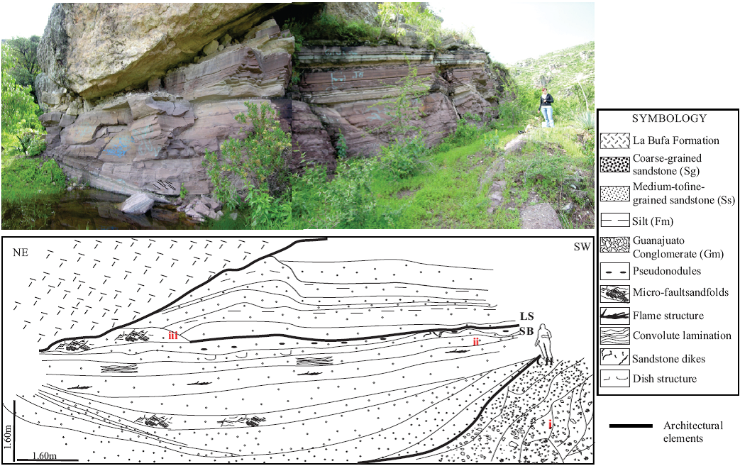
In the following section we describe centimetric soft-sediment deformation structures observed in the field along with a brief interpretation. Soft-sediment deformation structures are observed in horizontally bedded, sandstone and mudstone fluvial deposits of the Losero Formation. Deformation structures exist in different levels of these fluvial deposits with other sedimentary structures such as plane parallel laminae, desiccation cracks, ripples, cross-beds, antidunes, and groove and flute casts. These deformation structures have a good lateral continuity in each deformed bed, even though some of them show low deformational intensity. Soft-sediment deformation structures occur in a large variety of morphologies in the stratigraphic record of the Losero Formation. In the study area, two stratigraphic sections (Caídos and Socavón) (Figure 3) were measured in detail (facies distributions, primary structures and stacking patterns). The Caídos and Socavón sections contain soft-sediment deformation structures (Figure 3). Liquefaction and associated fluidization structures are present in several lithofacies types: fine-, medium- and coarse-grained sandstones intercalated with mudstone in the Caídos and Socavón sections (Figure 4). Many types of soft-sediment folds are recognized, including eye shaped folds, and symmetric and asymmetric folds (Figure 5; Table 4). Other types of deformation structures include sandstone dikes, pseudonodules, synsedimentary normal microfaults, convolute lamination, flame structures and dish structures (Figure 5). Distinct styles of deformation were observed in different bedforms. Deformation of trough cross-stratification has led to the development of asymmetric and symmetric folds and ruptured stratification. Horizontal bedding is typically modified in the form of sandstone dikes, pseudonodules, convolute and flame structures, which are described and interpreted in the following sections.
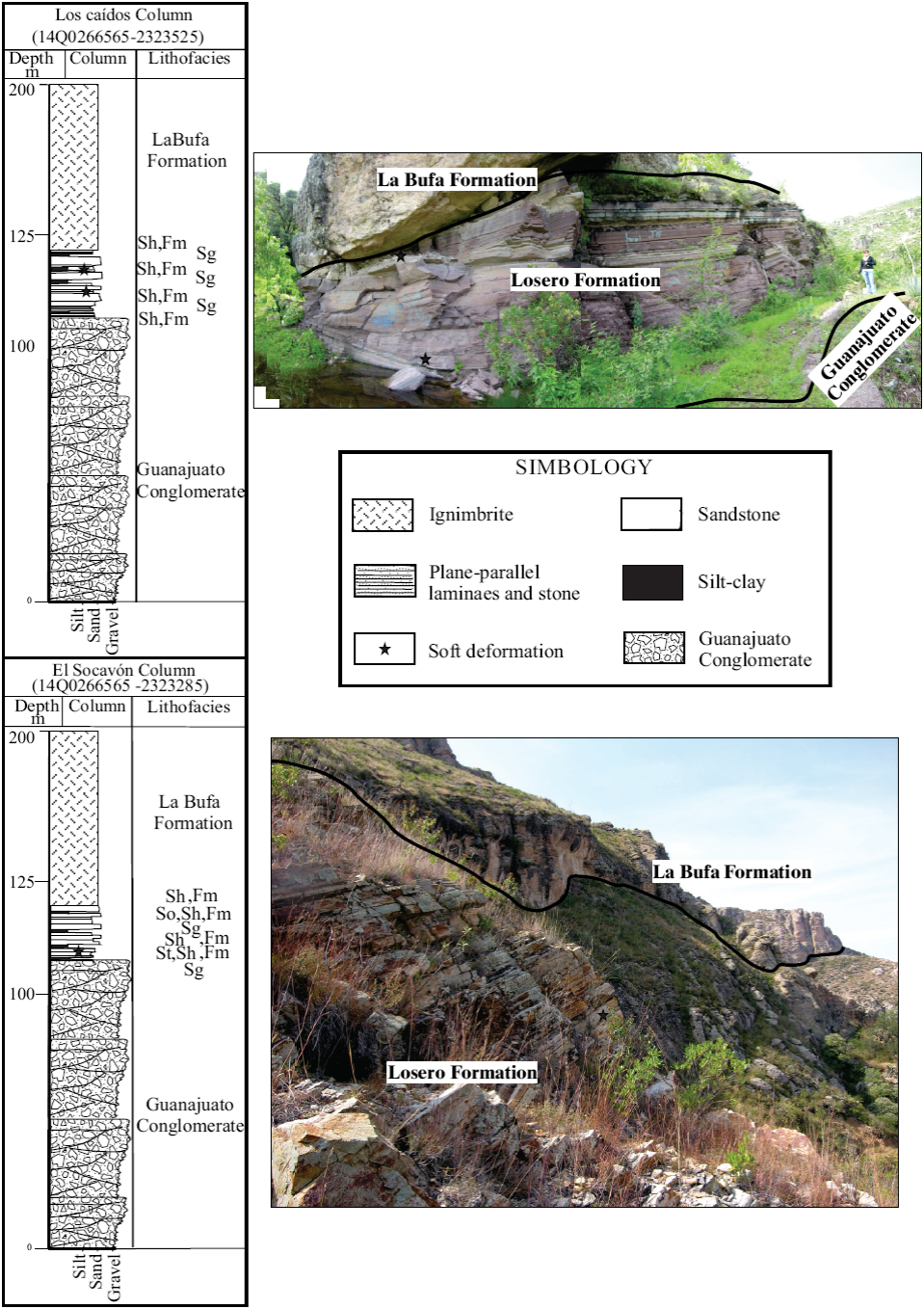
Figure 3 Lithostratigraphic columnar section of the Los Caídos and El Socavón localities. Facies, Fm: mudstone with desiccation cracks; Sg: coarse sandstone of brown color with normal gradation; Sh: medium to fine sandstone with plane parallel laminae and associated desiccation cracks; So: medium to fine sandstone with ripples of green color; St: medium sandstone with antidunes and cross laminations of green color.
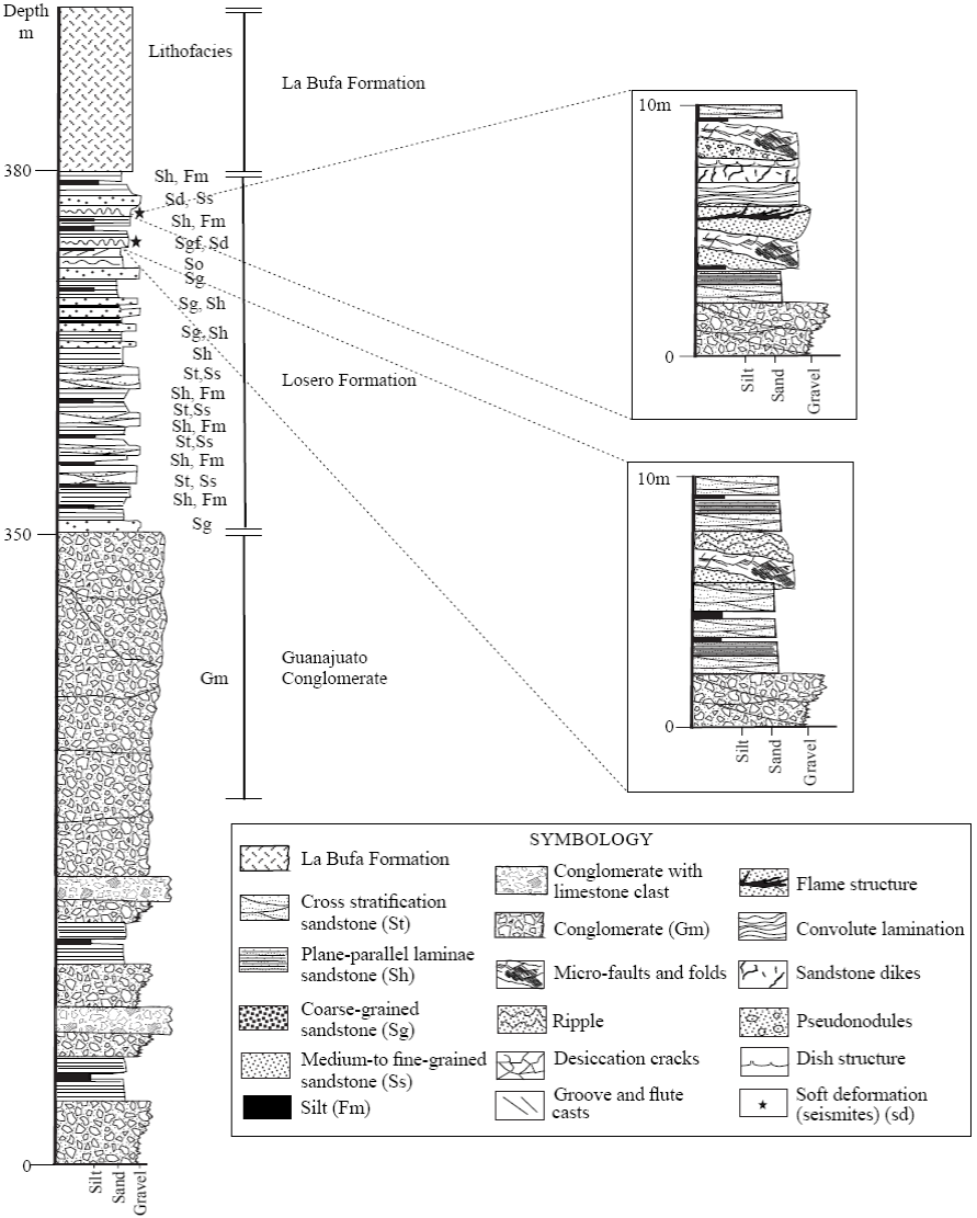
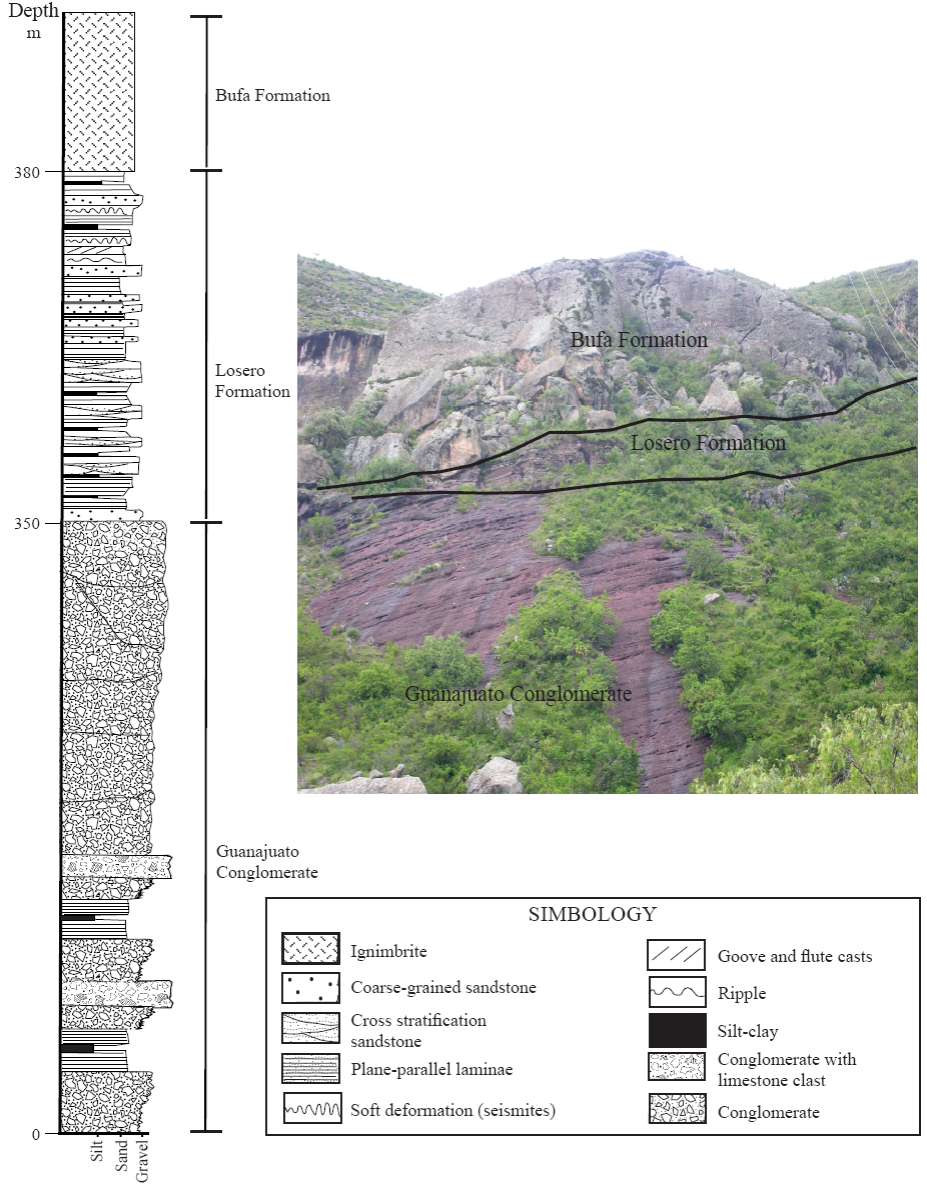
Figure 4 Generalized vertical log of the Losero Formation, with soft-sediment deformation occurrences shown as star to the right of the column, and detailed vertical logs to the right. Facies, Fm: mudstone with desiccation cracks; Sd: soft-sediment deformation structures interpreted as seismites associated with normal faults; Sg: coarse sandstone of brown color with normal gradation; Sgf: medium sandstone with groove and flute casts; Sh: medium to fine sandstone with plane parallel laminae and associated desiccation cracks; So: medium to fine sandstone with ripples of green color; Ss: medium sandstone with normal gradation; St: medium sandstone with antidunes and cross laminations of green color.

Figure 5 Outcrop examples of soft-sediment deformation in the Losero Formation. a: sandstone dikes structure; b: photography of sandstone dikes in medium-grained sandstone; c: pseudonodules; d: photography of the pseudonodules in medium-grained sandstone; e: dish structure; f: photography of dish structures in medium-grained sandstone; g: flame structures; h: photography of flame structures in medium-grained sandstone; i: fold and microfaults; j: photography of fold and microfaults, medium-grained sandstone; k: convolute lamination structure; l: photography of convolute lamination in medium-grained sandstone.

Sandstone dikes
In the Losero Formation of the Caídos section, sandstone dikes are recognized at various levels of the stratigraphic succession (Figure 2). The dikes, ranging from 0.5 cm wide and 0.7 cm long to 13 cm wide and 13 cm long, cut across layers of sandstone and mudstone (Figure 5; Table 4) . Sandstone dikes occur adjacent to flame and convolute structures. The major dikes bend the intruded layers upward by the subordinate display of opposite bending directions (Figure 5). In earthquake events, water-rich sandy sediment is injected into the argillaceous sediment and forms the vein body under pressure. The dike fills consist of homogeneous medium-grained sandstone of the same nature as the beds form which the dikes project upward. Dikes are straight to somewhat sinuous in plain view. In most cases, dikes are vertical in cross-section. These have been recognized in the Caídos section.
Interpretation. Bhattacharya and Bandyopadhyay (1998) suggest that clastic dikes form during fluidization of sediment when the source layer of the dike-forming sediment is more permeable than the overlying sediment layers. The origin of dikes has been ultimately related to the liquefaction of the basal saturated sand bed, possibly triggered by seismic shocks (Audermard and De Santis, 1991; Obermeier et al., 1993). According to Singh and Jain (2007), the clastic dikes are formed perpendicular to the propagation direction of earthquake waves.
Pseudonodules
In the study area; pseudonodules consisting of isolated masses of sediment of various morphologies embedded in an underlying deposit of contrasting density, are present in sandstone facies alternating with mudstones. They have been recognized only in one bed of the Caídos lithostratigraphic section (Figure 5; Table 4). Therein, the pseudonodules occur as a single, laterally extensive bed of 30 cm thickness. The pseudonodules are very irregular. They occur as balls of circular and elliptical shape in the observed heterolithic deposits (Figure 5). Diameters of circular pseudonodules vary between 3 to 5 cm. Long axes of the elliptical pseudonodules range between 2 to 5 cm and their short axes from 1 to 3 cm. Pseudonodules are often present in structural continuity with the convolute lamination.
Interpretation. Pseudonodules develop when the load-bearing strength of a sediment layer is lost due to the liquefaction of the interbedded sand-mud layer (Kundu and Goswani, 2008). Kuenen (1958) described the formation of pseudonodules, simulating the deformation behavior of sands overlying clays under the effect of shaking. In these conditions, the more dense sand sank into the clays as individual variously shaped masses. Experimentally, he showed that pseudonodules may form due to external shock. The pseudonodules present in the Losero Formation are composed of sandstone and claystone. This may be explained by the fact that, under seismic shaking, the liquefaction of clay decreases drastically its bulk density and shear strength allowing the sinking of the overlying sand layer (Allen, 1982).
Normal synsedimentary microfaults
The sedimentary layer hosting the faults is covered by undeformed sedimentary layers indicating synsedimentary origin of the faults. These structures consist of normal microfaults that affect the Losero beds, and were formed by liquefaction during an earthquake shock. These structures range from 3 mm to 5 cm length with a steep dip, and are associated with other soft-deformation features, mainly asymmetrical folds (Figure 5; Table 4). The fault spacing is about 0.5 - 2 cm and the slip is 0.3-1 cm. Locally, the normal microfaults define semigraben and graben-like structures with downsagging features. These have been recognized in both the Socavón and Caídos sections.
Interpretation. According to Anand and Jain (1987), and Miyata (1990), the synsedimentary faults are formed as a result of localized stresses induced by seismicity.
Asymmetric and symmetric folds
The asymmetrical folds show a wide variety of shapes and sizes, and their complexity is also highly variable. The folds consist of fine- to medium-grained sandstones intercalated with mudstones. Abundant asymmetrical folds include recumbent and overturned beds (Figure 5; Table 4). They usually include complex deformation structures, which range from several millimeters to some centimeters in thickness and extend laterally for several meters, containing different groups of folds. These pass laterally into other deformational features or undeformed intervals, including small-scale normal microfaults. The degree of disruption of the original lamination is extensive and the sediment mixing is also high. The folds provide evidence that deformation took place while the sediment was unconsolidated and had the consistency of a fluid. The frequently complicated shapes of these structures do not show any evidence of subsequent flattening. This fact suggests a rapid increase in viscosity/lithification after deformation. The asymmetrical folds can show a preferential orientation in a single complex structure, but the orientations are highly dispersed. They have been recognized in one bed of the Caídos section.
Interpretation. The asymmetrical and overturned folds developed under a hydroplastic behavior in a quasi-solid state (e.g., Lowe, 1975). The type of facies and the practical absence of water escape structures suggest a rapid recovery of viscosity towards the consolidated state by the sediment after deformation (Marco and Agnon, 2005). The presence of associated normal microfaults suggests a transitional behavior between brittle and ductile. The variable orientation of the axial planes of folds within each outcrop could suggest cyclic shear stress during earthquakes (McCalpin, 2009).
Convolute lamination
Convolute lamination is present in the sand-mud intercalated horizons (Figure 5; Table 4). The convolutions consist of randomly oriented anticlines and synclines, 3-15 cm in amplitude and 5-25 cm in width. Fold axial planes vary from vertical to sub-horizontal and lack preferential orientation. The fold size decreases as the intensity of folding increases upwards, and the higher convolutions are commonly disharmonic with respect to the lower ones. Convolute laminae are present in the form of trains of small folds of alternating convex-up and concave-up hinges, with unbroken dome-shaped crests and troughs (Figure 5). In the concave-up or convex-up folds, the axial planes become steeply inclined to subvertical and have been recognized in one bed of the Caídos section.
Interpretation. Both fluvial processes and earthquakes can cause liquefaction of sediment, leading to the formation of convolute lamination and different water escape structures (Allen, 1977; Chakraborty, 1977). When deformation is controlled by fluvial processes, the tops of the convolute lamina domes are more likely to be broken, due to the unidirectional fluvial flow (Selley et al. 1963). According to Reineck and Singh (1980), convolute bedding associated with erosional surfaces may form due to current drag in fluvial environments. Various authors (Middleton and Hampton 1973; Allen 1977; Chakraborty 1977; Cojan and Thiry 1992; Owen 1996; Rossetti 1999; Samaila et al. 2006) suggest that convolution is related to fluidization-liquefaction events, and concomitant expulsion of pore water. In the Losero beds, domes are intact and are not associated with erosional surfaces. These structures are restricted only to certain horizons, suggesting that transient triggering episodes were responsible for the development of such structures. Hence, deformation can be inferred to be syn-depositional and most likely the result of a seismic shock (Friend et al. 1976; Cojan and Thiry, 1992; Davies et al., 2004). Smooth folds indicate a liquefied state of the sediment during the folding.
Flame structures
These are present within heterolithic units comprised of very thin sand-mud interlaminations (Figure 5). These structures are formed by penetration of silty sediments into sandy deposits. Flame structures in close proximity to recumbent folds are directed upward at a very high angle to the bedding. The flames are blunt at their tips and also crenulated (Figure 5; Table 4). Associated deformation features within the same horizons in the vicinity of the flames consist of convolute laminations. Directions of the flames are upward, almost perpendicular to the paleocurrent direction. They are as much as 30 cm wide and 50 cm high. The frontal part of the flame structure associated with the convolute lamination shows a near orthogonal relation with the deformed lamination (Figure 5). The set of mudstone laminae that have taken the shape of the flames was originally 2-5 mm. They have been recognized in one bed of the Caídos section.
Interpretation. Formation of the flame structures is attributed to directional fluidization and escape of water due to density contrast between sand and mud layers along the interface (Collinson and Thompson, 1982). Flame structures may form by either one of the following processes: fluvial current drag (Kuenen and Menard, 1952) or pressure action due to loadings (Anketell et al., 1970). Those formed by fluidization resulting from the load of overlying sediments are associated with load structures; however, in the Losero sequence, load casts are conspicuously absent in the horizon that contains flame structures. Therefore, the development of flames can be ascribed to earthquake-induced fluidization and resulting water escape, rather than to an autocyclic sedimentary origin (Visher and Cunningham, 1981; Obermeier, 1996).
Dish structures
Dish structures are present in the mudstone interlayers of the heterolithic beds. The dishes are 3-5 cm wide, concave-up, thin laminar structures (Figure 5; Table 4). They are related to water movement in unconsolidated sediment due to sudden over pressure or seismic waves. The shape of dish structures may change depending on the amount of pressure, movement velocity of pore water and the degree of consolidation.
Interpretation. Dish structures develop in clastic sediments by liquefaction. They form by flowage of particles or fluid transport by upward-directed dewatering (Hirono, 2005). Impermeable or semi-permeable barriers within the sediment may cause the development of localized regions of high pore pressure in the fine-grained strata (Obermeier, 1996). They have been recognized in one bed of the Caídos section.
DISCUSSION
Depositional setting
The Losero Formation succession is interpreted as the product of the interaction between bedload-dominated and channel-braided fluvial systems, which underwent distinct variations in river flow discharge (Puy-Alquiza et al., 2014), but the possibility that these deposits have a volcanic origin is not discarded. Discharge variations are recorded by the alternation of cossets of trough cross-stratification and sets of horizontal lamination; nonetheless, this system preserves little evidence of flow cessation during deposition. The presence of a predominantly sandy to conglomeratic grain size fraction, internal erosional surfaces, and preservation of mudstone indicate that the rate of sediment supply was greater than the rate of accommodation generation and that the basin therefore, developed in an overfilled state. Depositional architecture in the Losero Formation is typically organized in 1 to 30 meter-thick cycles, each one beginning with an erosional scour, overlaid by channels and sandy bedforms, and passing upward to laminated sand sheets intercalated by mudstones (Figure 6). Preserved cycles of this type of structure are representative of fluvial systems that underwent marked variations in discharge; passing repeatedly between conditions responsible for the generation of lower- and upper flow regime bedforms (Fielding, 2006). The rare occurrence of mud bodies, the absence of preserved aeolian sets, and the sparse occurrence of low-flow regimen bedsets collectively indicate a semi-perennial to perennial hydrological regime.
Triggering mechanism
The most common structures related to soft-sediment deformation are: 1) overpressure of sediments (Lowe and Lo Piccolo, 1974; Lowe, 1975); 2) storm waves (Molina et al., 1998; Alfaro et al., 2002), and 3) seismic shakings (Seilacher, 1969; Rodríguez-Pascua et al., 2000; Bowman et al., 2004). Deformation structures in the Losero Formation were caused by a seismic shaking mechanism. The Losero Formation contains soft-deformation bed-set structures developed in a variety of primary facies types that originally accumulated in response to lower regime conditions (plane-parallel laminae associated with desiccation cracks), including subcritical flow (cross laminations and ripples), and upper flow-regime conditions (groove and flute casts). The amount of silt intercalated with sand is an important factor favoring soft-sediment deformation. The high concentration of silt causes dilatant flowage (Brodzikowski, 1981), spontaneous liquefaction, fluidization and thixo-tropic behavior (Boswell, 1948; Allen and Banks, 1972; Lowe, 1975).
The complex of soft-sediment deformation structures of the Losero Formation was formed in an initial multilayered reversed density gradient system. The heavy sands may sink into lighter sands and silts, accompanied by a drastic decrease, or complete loss of the shear strength of the sediments (Allen, 1982; Owen, 1987). The observed features, such as deformation of the primary lamination, indicate that the decrease of shear strength was induced by liquefaction. The formation of load structures was induced by partial gravitational readjustment acting simultaneously with the loss of shear strength in the sediments. Flame structures formed where this displacement of lighter sediment occurred vertically. At the base of the source layer, this motion occurred horizontally and such movement generated horizontal shear stress in the over-pressured sediment, making the silty laminae rolling up to form contorted bedding (Moretti et al., 1999). Flame structures associated to convolute structures represent denser sediment that sunk into less dense sediment. However, unidirectional flame structures in association with convolute structures and normal microfaults, which testify to horizontal extension in the uppermost deformed layer (Figure 5), indicate that during liquefaction, horizontal shear stress was acting on the sediment together with a gravitationally unstable density gradient. The convolute lamination is a complex form of load structure. Owen (1996) attributes some convolute laminations to a reversed bulk-density gradient on sand or on sand contacts. However, convolute laminations are in many cases associated with water escape structures (Allen, 1982; Rossetti, 1999; Moretti et al., 1999). According to Rodríguez-Pascua et al. (2000), during seismic shocks, horizontal shear strain forces poorly lithified or unconsolidated laminae to move upward in a first stage of deformation, forming a series of laterally adjacent folds. During this process, sinking of sand layers into muds produces features like pseudonodules.
The sandstone dikes contain pieces of the host silt to fine sand layer. In outcrop it appears as a 0.5 to 2 cm wide, and up to 10 cm high, irregularly shaped patch of sand (Figure 5) . The sandstone dikes completely cross the deformed interval. The thickness of the sandstone dikes decreases toward the SW of the Socavón sections, where sand dikes are not observed. They are particularly abundant and thicker in the Caídos section. This suggests that the seismic source may have been located in a NE direction, because sandstone dikes become thinner with greater distance from the epicenter (Munson et al., 1995; Obermeier, 1998). The combination or association of flame structures with sandstone dikes indicates a mixture of driving forces acting together during liquefaction (horizontal shear stress together with a gravitationally unstable density gradient). Liquefaction features are mainly generated by earthquake shaking (Youd, 1978; Allen, 1975; Seed, 1979). Atkinson (1984) mentioned that magnitude 5 earthquakes can produce liquefaction processes when suitable conditions exist. According to Perucca et al. (2009), liquefaction features are commonly related to close seismic source areas, and the width of sandstone dikes and the size of the associated structures could determine the most probable seismic source area. The uppermost deformed level in the Losero Formation is represented by the association of asymmetric and symmetric folds and synsedimentary normal microfaults. In this deformed interval, a combination of bulk-density heterogeneities and fluidization may have driven the deformation process. The complex and irregular morphologies described in the Losero Formation were induced by liquefaction and fluidization of the involved sediments in the presence of two main driving force systems (reversed density gradient and unequal loading). The analysis of sedimentological features of the entire succession containing the disturbed beds, and the detailed descriptions of soft-sediment deformation structures of the Losero Formation show that (1) deformation was induced by liquefaction and fluidization in an initial complex multilayered initial unstable density gradient system; (2) deformation involved fluvial-flood plain sediment; (3) deformation is absent in the beds located below and above the disturbed bed; (4) deformed and undeformed beds show similar lithologies and facies features; (5) liquefaction and fluidization effects are common in the Losero succession; (6) the association between asymmetric and symmetric folds and synsedimentary normal micro-faults indicate the activity of paleoearthquakes. According to locations and the distribution of soft-sediment deformation structures, these structures should have formed by more than one event of fault activity. The control of the regional tectonic pattern on the formation of the described structures interpreted as seismites, is especially marked in the sandstone dikes, pseudonodules, convolute and flame structures, fold and normal microfaults.
CONCLUSIONS
In this paper, the shapes, dimensions and location of soft-sediment deformation structures and facies properties of Eocene-Oligocene aged fluvial deposits of the Losero Formation are reported.
Soft-sediment deformation structures were studied in two sections (Caídos y Socavón) located in the mid-upper part of the Losero Formation. The Socavón section consists of a 20 m thick succession of coarse sand, fine sand and silt. The sand intervals show trough cross-bedding, ripples, plane-parallel laminae. Lithofacies of the Socavón section analysed herein are interpreted under the context of a fluvial system, and represent the lower member of the Losero Formation. The soft-sediment deformation structures are exposed in the lower part of the Socavón section. The deformed beds are made up of alternating fine-grained sandstone and siltstones. The lateral extent of the deformed horizon is some hundred metres long with a 1.5 m thickness and limited at the base and top by undeformed beds of similar facies. The general morphology of the deformed bed can be described as a complex vertical succession of different disturbed layers. The soft-sediment deformation structures are load-structures, and synsedimentary normal microfaults in the Socavón section are often only a few centimetres thick. Within the deformed layers, no flat surfaces indicating the occurrence of different deformation events are present, and the entire deformed thickness was disturbed by a single event. The second and higher deformed interval is less than 3 m thick and occurs within a laminated alternation of sand and silts, represented by the Caídos section. This section consists of a 10 m thick succession of fine sand and silt. Sand intervals show plane parallel laminae, antidunes, groove and flute casts, desiccation cracks, ripples, and cross bed sets. Beds of fine sand silts are interbedded. Lithofacies of Caídos section analyzed herein are interpreted under the context of flood plain, according to Miall (1996) fluvial system classification criteria, and represent the upper member of the Losero Formation. The soft-sediment deformation structures are exposed in upper part of the Caídos section. The deformed beds consist of alternating fine-grained sandstone and siltstones. The lateral extent of the deformed horizon is some hundred metres, with 2 m in thickness and is limited at the base and top by undeformed beds of similar facies. The general morphology of the deformed bed can be described as a complex vertical succession of different disturbed layers. The soft-sediment deformation structures are load-structures, mostly asymmetric and symmetric folds, dish, pseudonodules, sandstone dikes, flame, convolute structure, and synsedimentary normal faults. Within the deformed layers there are no flat surfaces indicating the occurrence of different deformation events, and the entire deformed thickness was disturbed by a single event.
Deformation varies from slightly to strongly distorted, and includes: a) asymmetric and symmetric folds, b) dish structures, c) pseudonodules, d) sandstone dikes, e) flame structures, f) synsedimentary normal microfaults and, g)convolute laminae.
A seismic origin of these structures is strongly suggested by: a) the occurrence of a wide variety of deformation structures in two levels in a 1-2 m thick unit; b) deformation structures are frequently observed in different levels of the sequence, alternating with undeformed, parallel beds; c) the deformed layers in the Socavón and Caídos sections are entirely consistent, constituting a level that is traceable all over the section under study. d) Thus, it must be deduced that the level with the two strongly deformed layers developed during an event that affected the sediments over an extensive area, and that the deformation processes involved were much stronger than before and after this event, and that the event included (at least) two deformation phases, shortly after one another in the form of aftershocks of an earthquake. These data suggest that the earthquakes should have affected the Losero Formation at the time of deposit of La Bufa Formation.
Fluidization and liquefaction played a major role in their genesis, suggesting exposure to a shock wave. In combination with the size of the deformation structures, which are much larger in the Caídos section than in the Socavón section, and in combination with the sudden tectonic activity, these two levels are interpreted as seismites. As they are present immediately on top of each other, they may reflect an earthquake and aftershocks.
The similarities of the soft-deformation structures with seismites described in the literature. These characteristics cannot be explained by other mechanisms, including gravitational or hydrodynamic processes.

