


Services on Demand
Journal
Article
 text in
  English (pdf)
 Article in xml format
 Article references
 Send this article by e-mail
Indicators
-
 Cited by SciELO
 -
 Access statistics
Related links
-
 Similars in
SciELO
Similars in
SciELO
Share

 Permalink
Frontera norte
On-line version ISSN 2594-0260Print version ISSN 0187-7372
Frontera norte vol.31 México 2019 Epub Jan 01, 2019
https://doi.org/10.33679/rfn.v1i1.2010
Article
Technological Changes in a Border Scene: The Arise of San Luis Rio Colorado, Sonora
1Universidad Autónoma de Baja California, México, samaniego@uabc.edu.mx
This paper shows how the implementation of hydraulic technology in the border area of Arizona created the conditions for the formation of the town and agricultural area of San Luis Río Colorado, Sonora. The work discusses how, given the geographical conditions imposed by the international waterway, investment in the United States brought about the conditions for the establishment of a settlement on the Mexican side of the border. Also discussed is how, despite the lack of investment in Mexico, it was possible to build the earliest canals without equipment, while on the American side a world-class feat of engineering was being built: the inverted siphon.
Keywords: Hydraulic technology; inverted siphon; complex; border area; San Luis Rio Colorado
El escrito muestra la forma en que la implementación de tecnología hidráulica en el límite fronterizo de Arizona, generó condiciones para la formación del poblado y la zona agrícola de San Luis Río Colorado, Sonora. Se analiza cómo a partir de las condiciones geográficas impuestas por la corriente hidrológica internacional, la inversión realizada en Estados Unidos propició condiciones para un asentamiento en la parte mexicana de la zona fronteriza en cuestión. De igual forma, se destaca cómo a pesar de la falta de inversión en México, fue posible realizar los primeros canales sin equipo, mientras que en la parte estadounidense se construyó un modelo de la ingeniería mundial, como fue el sifón invertido.
Palabras clave: tecnología hidráulica; sifón invertido; interdependencia compleja; zona fronteriza; San Luis Río Colorado
INTRODUCTION
This paper seeks to analyze one process considered to play a substantial role in the formation of the Mexico-U.S. border in terms of water resources: technological developments north of the border that led to actions in Mexico as a result of the construction of hydraulic works. With regulatory frameworks that failed to envisage all scenarios, especially in the first four decades of the 20th century, there was no coordination in actions or prior agreements, but the benefits for Mexico – such as the emergence of the town and agricultural region of San Luis Río Colorado, Sonora – were significant. This clearly contrasts with the prevailing discourse in which Mexico always loses out in its relationship with the United States. As noted in previous work, there exists a relationship, in terms of surface currents, that makes it necessary to observe the process in greater depth ( Samaniego, 2006 , 2012 ). Although the same may not be the case in other matters, as far as groundwater is concerned, there are also benefits for our country.
At the same time, this work seeks to highlight the fact that actions taken by Mexican authorities were in response to decisions made in the United States, while also giving an account of the establishment of a town and agricultural area with scant investment from the Mexican state and the state of Sonora. While in the United States there were discussions about the investment and which governmental office would perform the work, on the Mexican side, the emergence of San Luis Río Colorado was both a collateral effect of actions undertaken in the United States and the result of endeavors by social actors whose only resource was the labor they were able to offer to build the canals needed to cultivate land ( Verdugo, 1983 ). Particular emphasis should be placed on the manual aspect of the labor. While in Arizona and California huge dredgers were used and railroad tracks were built in anticipation of a project viewed as an engineering challenge (this will be dealt with in greater depth later), the canal that carried wastewater from the irrigation system in Yuma, Arizona, was built by the hands of men transported to the area for that very purpose – and so it was that an agricultural region was born with the reuse water from the immigration system in Yuma.
It should be mentioned that the International Boundary Commission (IBC), established by the Convention of 1889 but which began formal operations in 1894 ( Bustamante, 1999, pp. 21-22 ), lacked the conditions and regulatory framework to act. On other occasions it has been said that hydraulic technology developed at a faster pace than the agreements, which was what conditioned the treaties and conventions in a context in which measures taken beforehand affected, in one way or another, a binational space under construction ( Samaniego, 2006 ). This is relevant in explaining the process by which San Luis Río Colorado was formed, which was inextricably tied to changes in water levels in the United States. Furthermore, the town’s origin enables a broad analysis of the relationships between private enterprise, government institutions, geographical conditions, the implementation of technology, and opportunities that changed the way natural resources were used at a given point in history. It should be stressed that this paper does not seek to discuss a series of endeavors to populate the area from the mid-19th century as part of attempts by entrepreneurs to develop navigation in the Colorado River (as envisaged in the 1848 treaty between Mexico and the United States), but rather provide an account of the emergence of the town and agricultural region within a border setting in the second decade of the 20th century, during the years of the Mexican Revolution. Although there was indeed a ranch called San Luis in the area, it was used for low-scale cattle raising ( Verdugo, 1983 ). Even though this is no doubt significant in explaining the presence of various families in the area, and the place name, this paper argues that it was the hydraulic works in the Yuma Project that brought about the emergence of a town and the agricultural region in question.
For several years now, in analyzing the context of international rivers between Mexico and the United States ( Samaniego, 2006 , 2012 ), it has been noted that reports sent to the Secretariat of Foreign Affairs mentioned the agricultural potential of San Luis Río Colorado. In 1935, the engineers Jesús Franco Urías, Mariano Silva, and Isidro Díaz, suggested that on the left bank of the river it was possible to develop a total of 140,000 hectares (ha) ( ASRE2 , 1935 ). They noted it was called the San Luis Mesa, and believed it could be put to use for agriculture3 . However, the negotiations for the 1944 treaty only took into account the potential 200,000 ha in the Mexicali Valley ( Samaniego, 2006 ), and San Luis was not included in the 1,850.234 MCM (millions of cubic meters) negotiated in the treaty. However, at that time the cultivated area was 6,000 ha ( ASRE, 1937 ), a far cry from the growth of the agricultural region in Yuma, Arizona; the Mexicali Valley; and Imperial Valley in California, where cultivated land exceeded 50,000 ha and was constantly expanding4 .
Unlike in the Imperial and Mexicali valleys, and the Yuma Project, the action taken by the respective governments was permanent and final. Why was no case made for a water supply for San Luis during the negotiations on the distribution of the Colorado River? If the first appropriation/beneficial use principle could indeed have been applied –as indeed it was– why was San Luis Río Colorado not brought to the negotiating table? If the 1935 studies posited the potential development of 140,000 ha, why are 30,000 ha of land cultivated today, but as part of Irrigation District 014, which corresponds to the Mexicali Valley, instead of having its own assignment? For some journalists at the time, the answer was to promote the incorporation of the town into the Northern District of Baja California. This was the only way to guarantee water for the agricultural region, given the risk of being left without water due to the ongoing negotiations, which did not take into account the area in Sonora ( El Heraldo, 1927 )5 .
In 1930, Melchor Ortega, as representative of the Emilio Carranza district6 , argued before the chairman of the Board of International Waters that they had
[…] a pressing need to use the return water fom the system in Yuma, Arizona, on their land, considering that if it is not supplied or is prohibitively expensive, this will lead to the total collapse of the community, and hence its disappearance, and consequently, I deserve to have the water in question included in the treaty that is about to be signed, with the aim of ensuring it is kept in the best possible economic conditions ( ASRE, 1930 ) 7 .
Melchor Ortega’s message reveals a constant found in various records in the Historical Water Archive (AHA) in Mexico City: the well-founded fear of being excluded in negotiations. In addition, the 1932-1934 drought heightened fears about what would happen with San Luis Río Colorado ( AHA, n.d. ).
The answer explaining the emergence and growth of the agricultural region of San Luis Río Colorado from the 1940s lies in its cross-border dimension, the presence of a U.S. institution (the Reclamation Service), the U.S. Army Corps of Engineers8 , and technological advances that directly affected the emergence of the town and agricultural region. In other words, the town was founded in response to actions and decisions by engineers from across the border, and investment by the U.S. federal government. The use of this resource, conditioned by the aforementioned institution, was instrumental in establishing the agricultural region.
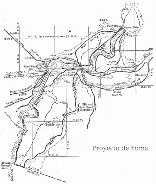
Source: Sykes, 1937. Translation: Proyecto de Yuma = The Yuma Project.
Map 1. The San Luis area in relation to the Imperial, Mexicali, and Yuma valleys
Before continuing, it is worth making a distinction. This article makes reference only to surface water, and not groundwater, given that from the 1930s the ability to harness this resource began to affect the extraction capacity, and therefore the ability to expand production areas. In the last few decades of the 20 th century and up to now, the legal agreements in Mexico by which water is supplied to cities like Mexicali, Tijuana, Tecate, and Ensenada are linked to developments in the complex Arizona-Sonora border relationship, and specifically, the groundwater flowing south toward Mexico in the San Luis Río Colorado area.
Moreover, it is believed that this article falls under what Robert Keohane and Joseph Nye (1977) have called “complex interdependence”. The authors suggest that interdependence is the limitation of the autonomy of action of parties to a relationship established on the basis of shared physical and geographical foundations. Although this concept was put forward in the context of the challenges of globalization in the 1970s, it enables an understanding of various key aspects in the historicity of the U.S.-Mexico border, especially regarding the bodies of water shared by both nations. It is however acknowledged that the authors applied this concept to the U.S.-Canada border, and not the U.S.-Mexico border. Nonetheless, it is considered relevant with respect to international waterways, as the strength of a nation does not detract from geographical issues. Similarly, as far as surface water is concerned, and in particular for the Colorado River, there was a clear need for investment in Mexican territory, so relations between businesses and government offices were subject to the necessary and interdependent linkage with Mexico. Other authors have elaborated on this relationship with respect to the use of water and national security in its various interpretations ( Cortez et al., 2005 ). It is this geographically imposed situation that explains the close dependence on the neighboring country in both directions.
IMPLICATIONS OF A RIVER WITH HIGH FLOW VARIABILITY IN THE CONSTRUCTION OF THE BORDER
Despite its name, San Luis Río Colorado, Sonora, did not take its water directly from the river, but rather the town emerged thanks to water that had already been used in the Yuma system in Arizona. This is linked to the high flow variability in the Colorado River in the late 19th and early 20th centuries ( La Rue, 1916 ; Allison, 1917 ; Problems of Imperial Valley, 1922 ; Colorado River Basin, 1928 ). Engineers who studied the current frequently mentioned this in documents, and this information was revisited in discussions in the U.S. Senate. These presentations stressed the variability of the current to explain the problem of controlling flooding at various locations, especially in the lower part of the basin9 . In other words, the variability of the current flowing toward the Gulf of California or areas of what are now the Imperial and Mexicali valleys prevented the higher mesas from accessing the water. Furthermore, the current naturally drifted toward Imperial Valley – below sea level – and in particular the so-called Salton Sea10 , which evidence suggests has existed since at least the mid-19th century ( Samaniego, 2015 ).
The Colorado River runs from north-east to south-west through the U.S. states of Wyoming, Utah, Colorado, Nevada, California, New Mexico, and Arizona. In Mexico, the river continues its course toward the Gulf of California and constitutes a significant portion of the division between Baja California and Sonora. However, due to the depression toward what are today the Imperial and Mexicali valleys, the watercourse was highly variable. This changeability led to legal confrontations regarding recognizable boundaries. The river is 2,250 kilometers long in total, 160 kilometers of which are located in Mexico. For 32 kilometers, it constitutes the international border between Mexico and the United States. In percentage terms, 99.28% of the river is on U.S. territory and just 0.72% in Mexico. The basin accounts for 8% of the surface area of the United States ( Problems of Imperial Valley, 1922 ).
The river has seen significant variations in volume. According to estimates in the second decade of the 20th century, the total average volume of the river was 22,000 MCM. During the years of drought, the volume dropped to a minimum of 7,000 MCM, but reached 27,000 MCM in years when water was abundant ( Problems of Imperial Valley, 1922 ). As already stated, the engineers involved in studying the river reported that flow velocity was extremely high. One consequence of this situation was the huge amount of suspended matter and/or sediments it carried down to the low delta, causing changes in the watercourse from one year to the next. This material was generally termed silt in discussions in the United States. One figure cited is 200 MCM of sediments received each year11 . This produced constant changes in the watercourse, requiring large investments in order to control the river, both by the U.S. federal government and the Southern Pacific railroad company, but also the Yuma farmers’ organization (which hoped to reap the benefits of controlling the river in the border area with the U.S. state of California, the Mexican state of Sonora, and the Northern District of Baja California). These sites are mentioned to highlight a premise: changing the river to benefit any of these places entailed changes in hydraulic works in other areas. As a result, for Yuma, in this case, investing meant building protective levees, which increased the current velocity and amount of suspended material that reached Mexico, thus affecting Imperial Valley, California, given that farmers had to invest in Mexican territory to guard against flooding ( Problems of Imperial Valley, 1922 ; Colorado River Basin, 1928 ).
This brief description would not be complete without mentioning the sporadic arrival of water from the Gila River, which sometimes caused the Colorado River to spill over and other years contributed virtually no water at all. It should be taken into account that various irrigation works were installed in water bodies in the first decade of the 20th century. Similarly, it should be noted that due to the high concentration of alluvial material it carried, Mexican authorities did not lay claim to the use of their waters. Simply put, so much water reached Mexico in the early decades of the 20th century that sporadic input from the Gila River was not taken into account, nor were there any complaints about the construction of dams in Arizona. The major issue was controlling the Colorado River, and when the Colorado River was mentioned, it was expected that the water and the huge amount of alluvial material were to be taken as a unified whole. It was the construction projects of the second half of the 20th century that developed a different way of situating the problem. Today the river is spoken of in direct relation to the water, which was impossible before these projects. Both the water and the huge amount of alluvial material needed controlling ( Samaniego, 2012 , 2015 )12 .
This is significant in explaining the emergence and formation of San Luis, given that individual and institutional interests were centered on the Imperial and Mexicali valleys and the Yuma Project. This was the result of investment by the U.S. government and the implementation of the most significant technological advances at the time, which enabled the town and the agricultural region to emerge in turn. In this case, when referring to technological advances, the intention is to situate this process within the framework of the policies by which these advances were researched and implemented by the Reclamation Service and the U.S. Army Corps of Engineers. This leads to a more in-depth analysis of what an international border is, and what the consequences have been for the relationship between two nations considered distinct, but which become complementary in their use of natural resources despite the lack of diplomatic agreements.
In other words, due to the way in which the Colorado River reached Mexico, it was not possible to exploit Sonora’s share. It was therefore the influence of the Yuma system that enabled the emergence of the agricultural region on Mexican soil. It should be noted that the lack of settlements did not mean there were no inhabitants, as several indigenous groups were present. In addition, by the early 20th century, there remained only traces of the various towns that existed in the 19th century, such as Mariposas, Gridiron, Ogden, Puerto Isabel, Lerdo, Nochebuena, and Hualapai ( Iglesias, 2012 ).
TECHNOLOGICAL INNOVATION: THE INVERTED SIPHON
The characteristics of the river described above meant that the Mexicali, Imperial, and Yuma valleys were closely interlinked and interdependent, given that construction work in one area created needs in another area, or proved complementary. Yuma went from being a military fort during the U.S. expansion process in the mid-19th century to developing agriculture in the 1880s and 1890s ( Skyes, 1937 ). However, the area was prone to flooding due to a river that could not be controlled without constant reinvestment ( Arizona Weekly Citizen, 1891 ; The Morning Call, 1891 ). Furthermore, the problem of suspended matter meant that irrigation canals were constantly being obstructed with silt. As a result, settlers in Yuma had to relocate several times from the last decades of the 19th century. This problem was compounded by the swelling of the Gila river, which, as stated above, practically dried up some years whereas in others the river flow was so powerful it became a threat. Thus, despite the semi-arid climate in the area, there were years when flooding led to a need to advocate federal investment. Several proposals put forward in the 1890s and various endeavors by companies to control the river envisaged the use of Mexican territory to vent potential hydraulic systems ( Enríquez, 1976, p. 149 ).
The Southern Pacific railroad company played a key role in the region. With the support of the federal government, the company invested in various projects to prevent the river’s course from disrupting the railroad tracks, and in the construction of a bridge that became the point of reference to estimate the height of the river level. On several occasions, like in 1891, it had to deal with flooding problems that affected both Mexican and U.S. territory, the dimension of the issue being similar for both countries. The difference was that if the tracks were to be preserved for the transportation of passengers and goods towards California, it was essential to take care of and maintain facilities ( Samaniego, 2015 ).
This led to a need for more significant investment, which is when the two most important federal institutions in this field in the U.S. stepped in: the Army Corps of Engineers and the Reclamation Service, formed in 1902. The Reclamation Service sought to convert arid and semi-arid areas into productive areas, and was of paramount importance for the western United States. Needless to say, it had no jurisdiction in Mexico, yet its proposals and actions have played a key role in many issues affecting northern Mexico.13 This paper will not address the various disputes between these institutions, but it should be mentioned that the Army Corps of Engineers and members of the Reclamation Service were constantly at odds. So it was, for example, that in the 19th century the army engineers began work on protective dikes to prevent the town of Yuma from flooding when the river swelled. However, soon after its establishment in 1902, the Reclamation Service took action in the area and the established systems were purchased from distribution companies ( National Archives, Denver, n.d.a ).14 This meant a change in the presence of the federal government and the prospects for building right next to the international border. Similarly, this had an impact on the protective levees built on U.S. territory as it produced a faster current, which had immediate impacts both on Mexican territory and in the United States within the Imperial Valley region15 ( National Archive Denver, s.f.b ). It also meant a change in land tenure for the indigenous communities of the region, as they were a priority for this federal agency ( Sauder, 2009 ).
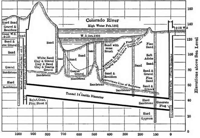
Given the changes in river flow in the years with greatest runoff, the problem was how to divert the water while reducing the effects of suspended material. Francisco L. Sellew, chief engineer, based his work on some models used in India ( Arizona Sentinel, 1911 ). It is worth highlighting that in several cases and in the preceding years, the United States Geological Survey, under John W. Powell, had supported various proposals for construction work on the site. Sellew proposed an inverted siphon. To this effect, a diversion dam called the Laguna dam had to be built first, followed by the inverted siphon. A siphon is a way to divert water from a river, using the pressure it generates to carry it to a higher altitude and then bring it down again ( Arizona Republican, 1908 ). The idea drew attention in many parts of the world. Sellew proposed digging a 30-foot-deep entrance on the California side and installing the siphon underneath the riverbed, for it to reemerge on the Arizona side ( The Arizona Republic, 1908 ). Simply put, a tunnel would be built under the river to carry the water from California to Arizona. This meant less investment and the opportunity to use 12,000 more acres than initially planned. In this 1913 illustration by Newell, shown below, it should be noted that the 14-inch diameter tunnel goes under the Colorado River, which was uncontrolled at that point.
The construction of the Laguna dam was a huge challenge in itself, particularly with regard to transporting material and labor. The summer heat, which reaches over 115 ºF in the region, discouraged laborers from relocating. In his report, Sellew noted the importance of Mexican laborers, but did not offer any precise figures due to turnover as a result of the high temperatures. The Southern Pacific railroad company yet again played a key role in the whole process. It should be taken into account that between 1905 and 1907, the Colorado River had been the center of attention of governments in Arizona and California and Theodore Roosevelt himself, because of concerns that the Imperial and Mexicali valleys could be lost to flooding. This was the context in which the federal government invested a million dollars in Mexican territory without the approval of the government of Porfirio Díaz. This was because, as mentioned above, it was Imperial Valley in California that stood to gain the most.
The Laguna dam may well have been a key focus of discussions among engineers in the western United States due to the fact it was one of the first attempts to gain partial control of the river, but it was the inverted siphon that sparked greater interest in this issue. The future prospects offered by this project led people to claim that Yuma would become one of the most important agricultural regions in the world. The proposal required more levees on California territory, leading to suggestions that Yuma should be annexed to California. In 1909 work began on the inverted siphon. To this end, specialized divers were hired, along with local indigenous people ( Imperial Valley Press, 1910 ). It is worth noting that major investments were made in the region while the work was being carried out, in order to partially control the river for the benefit of the Imperial and Mexicali valleys on the basis of significant funding from the U.S. federal government, led by Taft at the time, in Mexican territory ( Samaniego, 2006 , 2012 , 2015 ). As a result, at the outbreak of the Mexican revolution, the region was engaged in major technological change, sustained primarily by the Reclamation Service. In this context, annexation proposals were put forward on a daily basis from various sectors within Arizona and California. These same proposals also believed that the real solution to their problems was to move the border southwards ( Samaniego, 2008 ).
Work was performed on the inverted siphon from 1909 to 1912, clearly a tumultuous period for Mexico ( Arizona Sentinel, 1910 ). In 1911 an armed group, initially under the banner of the Mexican Liberal Party, occupied various settlements in the Northern District of Baja California. This raised tensions in the area given the size of U.S. federal investments on both sides of the international boundary, in states such as Arizona, California, and the Northern District of Baja California16 ( ASRE, n.d. ). The completion of the inverted siphon in 1912 was met with great jubilation and high expectations17 ( Arizona Sentinel, 1912 ). The Mexican consul in Yuma, Acensión G. Lerma, reported in June 1912, for instance:
Huge crowds had gathered on this side of the Colorado River. Mexicans and Americans, whose sweat and weariness had executed the project; those whose minds had directed it. The masterpiece was complete. Nature itself seemed to have resolved to celebrate this triumph of human intelligence, and in an admission of defeat or a revelation that we have much yet to reap from its immense riches, rain began pouring down, as much or more water than that which was beginning to fill the canal. A day of rightful joy for this city, of congratulations for those who, over the space of seven long years, spared neither time nor money to achieve victory, the reward for their efforts and entrepreneurship. From today, water, that nurturing liquid, shall cross the once arid, deserted valley, unhindered in any way, and farmers shall, with their steadfastness and intelligence, be able to use it to produce the yield that will provide the sustenance and wealth they so deserve. They want this done in Mexico, for water to be leased or purchased and used to easily transform thousands of hectares of arid land –which today lie fallow– into beautiful orchards; and, where today land is barely inhabited by vixens and owls, for thousands of huts and country homes to rise up, majestically and joyfully, and house thousands of our fellow countrymen ( ASRE, 1912 ).
Such marked enthusiasm from the Mexican consul was tempered by the engineer Fernando Beltrán y Puga, the Mexican commissioner at the International Boundary Commission (IBC), who warned of future conflicts over interpretation of the international nature of the Colorado River. Also worth noting is that Beltrán y Puga faced a similar problem in the upper Río Grande as a result of the 1906 treaty, which gave rise to different interpretations in those years ( Hundley, 1963 ; Enríquez, 1976 ; Samaniego, 2006 ). Similarly, at the same time, the Chamizal issue in Chihuahua and Texas triggered a dispute that was not resolved until the 1960s.
Once the inverted siphon had begun to operate, drainage systems were built. As noted above, suspended material was a serious problem for the operation of the canal system, and the lower down the river it was, the greater the conflict. Both in Yuma and in Imperial and Mexicali, the issue cropped up every year, as the irrigation systems easily silted up. The solution provided by the engineers of the Reclamation Service had direct consequences for the subject of this paper. They built drainage systems that carried wastewater toward Mexican territory. Simply put, the drainage system ended at the international boundary, meaning the water used in the Yuma agricultural system was carried through into Mexican territory ( National Archives Denver, n.d.c ).
Intensive negotiations with the U.S. senate were required to receive approval for resources for these projects. Elwood Mead, a users’ representative and one of the most highly distinguished lawyers for managing to impose the principle of first appropriation in the western United States, led the negotiations.18 Farmers in Yuma complained about the formation of pools of agricultural wastewater. This water ran back toward their crops, doing nothing to alleviate the saltpeter problem. Furthermore, from 1913 and 1914, with financial liabilities toward the federal government, criticism of the Reclamation Service became significant ( Yuma Daily Examiner, 1915 ). Indeed, some journalists were harsh critics of Sellew and the institution. The enthusiasm of previous years waned and stances were taken with respect to the harm caused to Indian land in the region ( Sauder, 2009 ).
In other words, the problem from the 1890s in canals that took the water directly from the river had now –with the opening up of more land and the construction of a drainage system– been replaced with pools that meant that water ran back due to infiltration, affecting crops. As a result, with the debt problem, the presence of the Reclamation Service, and the bodies of water being formed, more federal investment was sought to solve the issue caused by the saltpeter. The stance taken was to criticize the Reclamation Service and create a new project that would solve the problem ( Arizona Sentinel, 1915 ).
Consequently, after a series of actions taken with the federal government, the second stage of the Yuma project began. The surplus, return flow and drainage that formed the pools would be released toward Mexican territory. Although it is unclear exactly when the work began, the information available indicates that by March 1917 the pumps were operating. An article dated March 1st in the Arizona Sentinel discussed the changes in the canals and assured readers that the system was fulfilling its purpose. The author of the article estimated that the extraction work had succeeded in reducing the height of the pools formed by between eight and ten feet, and furthermore, invited all those concerned to witness the progress for themselves.
The paradox is that it was this water that allowed San Luis Río Colorado to take root. Certainly, this was not top-quality water, but through the pumping systems, which the Reclamation Service was paid for, the town and agricultural region were able to emerge. The paradoxical nature of this is worth stressing, since the mighty river had always been there, at Mexico’s disposal, but the changing river flow and suspended material made it impossible to leverage, especially with no investment.
So it was that in March 1917 the pumping systems were in operation. In the following months, reports were published insisting on the need for functional drainage systems, given that the pools were becoming a huge problem ( Arizona Sentinel, 1917 ). This issue reemerged over the following decades, with changes in the relationship between farmers and the Reclamation Service, and the subsequent presence of a private company. This study will not explore this in further depth.
THE ESTABLISHMENT OF A TOWN AND AGRICULTURAL REGION AMIDST DESERT, WETLAND, AND A MIGHTY RIVER
Speculations on the ownership of land in the border area between the Northern District of Baja California and Sonora in Mexico, and California and Arizona in the United States, had begun decades beforehand. Early expeditions were sent out by the U.S. congress practically as soon as the land was purchased in the 1850s. Soon afterward, it was noted that occupation of the territory came with the prospect of controlling the water in the Colorado River. Simply put, it was a lot of water, with a huge amount of suspended material, and this combination was so significant that controlling the river was most important.
The Arizona and Sonora deserts were known as the Camino del Diablo (“Devil’s Highway”), and texts were written describing the difficulty of passing through the region. Narratives include accounts of how adventurers died trying to cross the Desierto de Altar with no knowledge of the area ( Sykes, 1927 ).
Previous pages mentioned short-lived hamlets such as Mariposas, Gridiron, Ogden, Puerto Isabel, Lerdo, Nochebuena, and Hualapai ( Iglesias, 2012 ; Verdugo, 1983 ). One way to summarize their presence and disappearance is through the interests of businessmen, for the most part American, who sought to use the waterway for transport, given that Mexico allowed boats entry through the Gulf of California in the 1848 treaty. The Mexican diplomat Guillermo Andrade’s engagement set him apart from the various foreigners involved in the region. Although Article 6 of the treaty stated that transit was only for navigation on water, and not by land, the truth is that – without Mexico’s express consent – towns emerged and disappeared with little or no intervention from federal or state authorities19 . The main occupation in Rancho San Luis, as noted above, was low-scale cattle raising. As a result, the area was home to local ranchers, several of which were the result of the emergence of these settlements, especially Lerdo. One paradox here is that in Arizona, Mexicans were of primary importance and their presence was a cause for concern, to the extent that they were referred to as “Tucsonan” – i.e. of Mexican origin – due to their high numbers ( Sheridan, 1986 ). Similarly, in Phoenix and Salt River Valley, Mexicans made up a majority ( Tinker, 1997, pp. 104-105 ; Arreola, 2014 ).
Mexican investors like Pablo Martínez del Río showed an interest in developing the region, first on the so-called left bank of the river, on the Sonoran side ( Enríquez, 1976 ). One of the conclusions reached by U.S. engineers from the Southern Pacific railroad company was that the most viable option was to develop the right bank, on the side now known as the Mexicali and Imperial valleys. The companies established exploited legal loopholes relating to the valleys, enabling Guillermo Andrade to acquire 15,721 hectares in 1894, in part of what is today San Luis Río Colorado. By doing so, he owned both sides of the river, and claimed rights to the river based on so-called riparian rights, an American concept under discussion in California20 . He later sold his properties to the Colorado River Land Company, which owned much of the land in what is today the Mexicali Valley. However, legally speaking, the purpose for which both sides were purchased did not hold up, whether for the Sonoran or the Baja California side21 .
Since work began in 1907, Mexican authorities recorded attempts to make use of the water resource, which would be controlled upon reaching Mexico22 ( Historical Water Archive [AHA], 1907 , 1910 ). In 1910, the Mexican commissioner for the IBC even suggested to Manuel Calero, the undersecretary of development under Porfirio Díaz, that there was a possibility of receiving water officially through the Yuma system23 ( ASRE, 1910 ). However, the experience with the 1906 treaty in the upper Río Grande raised challenges in interpreting the international status of the river ( Enríquez, 1976 ; Samaniego, 2006 ). The upshot of this was that the Mexican government refused to grant concessions to applicants until a formal agreement was reached with the United States24 ( Historical Water Archive, 1912 ). This stance was only upheld during the Díaz, León de la Barra and Francisco I. Madero administrations. Although there were formal attempts by Victoriano Huerta to reach an agreement, it is clear that a lack of recognition by Woodrow Wilson destroyed the chances of making headway in negotiations. Similarly, although some applicants were Mexican, they represented companies founded by Americans25 . It is also worth mentioning that states in the upper basin were apprehensive about land exploitation further down, as they anticipated that, if the principle of first appropriation was applied, their future rights would be affected. For this reason, the actions of the Reclamation Service in Yuma were called into question by representatives of states like Colorado, Wyoming, and Utah.
On the other hand, as a result of the entry of the U.S. into World War I and future projections regarding the Colorado River, the League of the Southwest was formed ( Los Angeles Herald, 1917 ). One of the main issues was the rights and opportunities provided by engineering developments associated with the Colorado River ( Hundley, 1975 ). This association encompassed various different viewpoints, but one of the most prominent beliefs was that a plan should be implemented to welcome soldiers back. As noted above, irrigation and the changes it brings about were the basis for mapping out the future, which included the rights pertaining to all the states in the basin, each of which wished to claim as much as possible for itself.
THE FOUNDING EXPEDITION OF CAPTAIN CARLOS G. CALLES
Indications of any invasion, annexation, exchange or purchase of Baja California or a part of Sonora, and in particular the areas around the river banks, were a constant topic in fora, the press, development projects, and political campaigns in the southwestern United States. The country’s entry into World War I, along with the complex negotiation process that entailed the punitive expedition in search of Francisco Villa, led to the region becoming the object of all kinds of speculations ( Katz, 1998 ). Although the population was small, especially on the Sonoran side, the importance of the area as a whole, and associated investments in California and Baja California, increased expectations regarding the future development of the entire Colorado Basin. Immigration by workers from China, and the arrival in the state of Japanese migrants from California, led to all kinds of discourse about the possibility of Asian invasions if they were permitted to remain on Mexican territory ( Keith, 1949 ; Boime, 2009 ). In other words, the limited population increased speculation about who would appropriate the space and in what way, above all because opening up land to agriculture in the lower region was considered a threat for states higher up.
In light of the possibility of opening up land to agriculture as a result of the Yuma project, the federal government sent logistical and military support. An expedition was formed to establish military colonies in the region. General Francisco R. Serrano was responsible for commissioning First Captain Carlos G. Calles, the nephew of Plutarco Elías Calles and Arnulfo Gómez, as head of the mission26 . The information available in the record established and found in the General Archive of the State of Sonora, seemingly taken from various authors, shows that the expedition was made up of 442 people, including both civilian families and soldiers. They had eight horses and fifteen mules. Members of the expedition had a range of occupations and included mechanics, health workers, farmers, and several agronomists.
The official document noted that the objective was to establish colonies on “… land that has for so many years been taken up by various concessions that have cost our country dearly…” ( General Archive of the State of Sonora, n.d. ). This was without a doubt a touch of nationalism that gave rise to discourse in defense of the Mexican nation during the emergence of the town and agricultural region. However, this claim is undermined to an extent by the fact that the company that owned the land where the settlement was established remained the property of the Colorado River Land Company for several more years. It must also be mentioned that Pablo Martínez del Río’s concession in the Altar district was revoked by the federal government in 1917, but this was not necessarily in the area where the agricultural region was developed.
So it was that the expedition, led by First Captain Carlos G. Calles and spurred on by nationalist contentions, began its journey in March 191727 . The date is explicitly given here to highlight the fact that this was the same month in which the pumping system that drove wastewater out toward Mexican territory began to operate. The information available suggests that although no formal arrangements were made, the Mexican authorities were indeed aware of the existence of controlled water crossing into the country.
The logistical difficulties were diverse in nature. In narratives, information about where a settlement could be established was obtained through conversation with local residents, who offered suggestions for the journey. The main problems were the fear of the river flooding, and difficulty understanding where Sonora ended and which areas belonged to Baja California. The river, with its frequent changes, had several watercourses, which, if any were confirmed, significantly affected the chances of establishing the intended colony ( Verdugo, 1983 ). However, although various sites were surveyed as suitable, the reality of the river imposed itself. It was not possible to settle on land prone to flooding. Therefore, four months later, their option was to use the water from the Yuma system. This had the advantage of being controlled water on higher ground that was less susceptible to flooding. Also, and above all, the Reclamation Service was prepared to pump the water toward Mexican territory.
As noted above, the Reclamation Service went from being the savior and developer to being the tyrant that subjected Yuma’s farmers to payments considered costly. The debt was substantial, and U.S. farmers were engaged in discussions about the way in which they were forced to bear the costs. The situation was similar in other projects led by the institution, which faced criticism due to the federal government’s encroachment on areas considered to pertain to states or territories ( Pisani, 1979 )28 . The fact that Calles’ expedition arrived there after a challenging four-month trek through the Desierto de Altar in June 1917 suggests that the pumping system was known to them.
Without representation and without taking into account the International Boundary Commission, Carlos G. Calles reached an informal agreement with the Reclamation Service. The institution’s engineers pumped water over one of the protective levees, providing the resource needed to fulfill the goal of establishing a settlement ( Enríquez, 1976, p. 457 ). Thus, Mexican soldiers from the 4th and 53rd infantry battalions, without proper equipment, built a canal 40 kilometers long and 10 meters wide. They cleaned up the land, opened up dirt roads, and built irrigation ditches.
María Isabel Verdugo (1983) explained that the canals were opened up by hand, on the basis of interviews with local farmers. Accounts by Trinidad Quintero and J. Dolores Ayala support her claim that this was the way the water was used. At the time, no roads existed in Mexico to transport equipment to the region –so while the Yuma project implemented cutting-edge technological breakthroughs, on the Mexican side, irrigation ditches and canals were being built by hand. This aspect is worth stressing to contextualize what I have referred to as the “border setting”. On the one hand, it serves as a point of comparison, and on the other, as a paradox: surplus water with excess salinity (and referred to as wastewater) was the starting point for an agricultural community in northern Mexico in the second decade of the 20th century.
CONCLUSIONS
This work has discussed how San Luis Río Colorado came into being, but the way in which wastewater was delivered changed several times in subsequent years. In the 1920s it was pumped by a private company, before delivery reverted to the Bureau of Reclamation, which was the name adopted by the institution from 1923 ( Enríquez, 1976, p. 458 ). All this fueled conflict between Mexican users and their relationship with the use of space. With the provision of communally-held ejido land29 in the following years, the process was adapted to meet the new needs.
In addition, due to the international nature of the Colorado River, what happened in San Luis Río Colorado became, at times, a legal issue. If it was considered river water, it was indeed international, and the fact that a private company was supplying it gave rise to various stances in negotiations concerning the Río Grande and Colorado River. The legal implications were different if it was supplied by the Bureau, as a public entity with specific responsibilities within U.S. borders. For Mexican negotiators, the question was whether or not to include San Luis on the negotiating table. For Ernesto Enríquez Coyro, who led the negotiations, this had little appeal. His work cited in this study makes no explicit reference to this, but the treaty he agreed to did not expressly include San Luis. As noted, in formal terms, the San Luis Río Colorado Valley belongs to Irrigation District 014, Colorado River, Sonora and Baja California; in other words, it was included in the amount of water requested for the Mexicali Valley. This explains why at the beginning, this study noted that as far as engineers Jesús Franco Urías, Mariano Silva, and Isidro Díaz were concerned, arable land spanned 140,000 hectares. In other words, if San Luis had been included, the negotiations would have followed a different path. This is not to say they would have obtained more water, since the surrounding states, especially Arizona and California, were against providing water to Mexican territory. Arizona representatives were particularly opposed.
On the other hand, this study has highlighted that initially wastewater was used from the Yuma system, in a demonstration of what I refer to as a “border setting”. In other words, although the poor quality of the water was a drawback, it proved essential in populating and occupying the area. The aforementioned discussions on annexation proposals made it imperative to take steps in that sense. However, resources were scarce. While across the border the latest technological advances were being used, on the Mexican side (as noted above) the Sánchez Mejorada canal was being dug by hand.
Another aspect of the border setting is the consideration that this was surplus water – wastewater that had already been used for farming. I believe this aspect compels us to give some thought to the implications of technological changes and the resulting impact on the use of space. Despite its poor quality, this water gave rise to a town and agricultural region. This situation remained unchanged for at least two decades. Even so, the town established itself and was able to increase its production area. The completion of the Boulder dam in 1935 set in motion other kinds of changes for the basin as a whole, and specifically the region in question.
Without a doubt, the implementation of the inverted siphon changed the way space was used on this border. As part of a system, it played a paramount role in changing relations in a particularly complex region that had four closely linked agricultural regions in addition to a problematic broader relationship with the basin as a whole. Opening up agricultural land lower down the basin represented a threat to riverside communities further up. Shortly afterwards, this produced agreements and disputes that remain a major part of the daily lives of millions of people today.
REFERENCES
Boulder Canyon Reclamation Project, (1928). Senate, 69th Congress, 1ª. Sesión, Reporte No. 654. [ Links ]
Problems of Imperial Valley and Vicinity. (1922) Senate, 67th. Congress, 2ª. Sesión, documento No. 142. Washington: Government Printing Office. [ Links ]
Allison, J. C. (1917). Control of the Colorado River as Related to the Protection of Imperial Valley. Transactions of the American Society of Civil Engineers, LXXXI(1), 297-325. [ Links ]
Archivo de la Secretaría de Relaciones Exteriores (ASRE). (1910). Informe del ingeniero Fernando Beltrán y Puga, comisionado mexicano de la CIl, al Secretario de Relaciones Exteriores. Fondo CILA, Caja 181 X-5505. [ Links ]
Archivo de la Secretaría de Relaciones Exteriores (ASRE). (1930). Fondo Comisión Internacional de Límites y Aguas, Fondo CILA. Caja 166. X-5487 – 4. Carta de Melchor Ortega al presidente de la Junta de Aguas Internacionales, 13 de septiembre de 1930. [ Links ]
Archivo de la Secretaría de Relaciones Exteriores (ASRE). (29 de junio, 1912). Informe del cónsul de México en Yuma, Arizona, Ascensión G. Lerma, al Secretario de Relaciones Exteriores. Fondo CILA, exp. X-33-2, VI parte. [ Links ]
Archivo de la Secretaría de Relaciones Exteriores (ASRE). (6 de mayo, 1935). Estudio de los ingenieros Jesús Franco Urías, Mariano Silva e Isidro Díaz, a la Secretaría de Relaciones Exteriores. Fondo CILA, Caja 175. X/224.1(72:73) (rc)/585. [ Links ]
Archivo de la Secretaría de Relaciones Exteriores (ASRE). (abril de 1937). Informe del ingeniero Rafael Fernández MacGregor, comisionado de la CIL. Fondo CILA, Caja 182. X –5506–2. [ Links ]
Archivo de la Secretaría de Relaciones Exteriores (ASRE). (s.f.). Fondo CILA, exp. X-33-2, IV y V parte. [ Links ]
Archivo General del Estado de Sonora (AGES). (s.f.). Ramo de Aguas. Tomo 3213, exp. 3. [ Links ]
Archivo Histórico del Agua (AHA). (25 de enero, 1912). Respuesta de Luis García representante de la 4 división zona 1 de la Secretaría de Fomento a Indalecio Sánchez Gavito representante de la Compañía de Terrenos de Sonora y la Baja California. Caja 1057, exp. 14 900. [ Links ]
Archivo Histórico del Agua (AHA). (27 de mayo, 1907). Carlos Garza Cortina, en representación de los Sres. P. Sandoval y compañía, solicitaron la compraventa de y piden 82 000 litros por segundo. Caja 1067, exp. 15 032 [ Links ]
Archivo Histórico del Agua (AHA). (31 de diciembre, 1910). Indalecio Sánchez Gavito, representante de la Compañía de Terrenos de Sonora y la Baja California solicitó 100 M3 por segundo. Caja 1057, exp. 14 900. [ Links ]
Archivo Histórico del Agua (AHA). (s.f.) Caja 1542, exp. 21 427; Caja 2838, exp. 35 391; Caja 1252, exp. 17 214. [ Links ]
Arreola, D. (2014). Phoenix Population Origins, 1870-1900. Geographical Review, 104(4), 439-458. [ Links ]
Boime, E. (2009). Beating Plowshares into Swords. The Colorado River Delta, the Yellow Peril, and the Movement for Federal Reclamation. Pacific Historical Review, 78(1), 27-53. [ Links ]
Bustamante, J. (1999). La Comisión Internacional de Límites y Aguas entre México y Estados Unidos, sus orígenes y su actuación hasta 1996. Ciudad Juárez, Chihuahua: Universidad Autónoma de Ciudad Juárez-San Diego State University-New Mexico State University. [ Links ]
Colorado River Basin. Hearings before the Committe on Irrigation and Reclamation United States Senate. (1928). Congreso de Estados Unidos 70, 1ª. Sesión, 17-21 de enero de 1928. [ Links ]
Cortez, A., Whiteford, S. y Chávez M. (Coords.). (2005). Seguridad, agua y desarrollo. El futuro de la frontera México-Estados Unidos. Tijuana, México: El Colegio de la Frontera Norte-Michigan State University. [ Links ]
Drainage Question in Yuma Valley Acute Stage. (1917, 25 de octubre). Arizona Sentinel, p. 1. [ Links ]
Enríquez, E. (1976). El tratado entre México y los Estados Unidos de América sobre ríos Internacionales. Una lucha nacional de noventa años. México: Facultad de Ciencias Políticas y Sociales-Universidad Nacional Autónoma de México. [ Links ]
Hundley, C. (1975). Water and the west. The Colorado River Compact and the Politics of Water in the American West. Los Angeles, Ca: University of California Press. [ Links ]
Iglesias, F. (2012). Puerto Isabel. Un puerto norteamericano en tierra americana, 1864-1878. Tijuana, Baja California: Edición de autor. [ Links ]
Katz, F. (1998). Pancho Villa. México, D.F.: Era. [ Links ]
Keith, E. (1949). The United States interests in Lower California (tesis doctoral). University of California. [ Links ]
Keohane, O. y Nye, J. (1977). Power and Interdependence: World Politics in Transition, Boston: Little Brown. [ Links ]
La Rue, E. C. (1916). Colorado River and its Utilization. Department of Interior, United States Geological Survey, Water Supply Paper (395), Government Printing Office, Washington. [ Links ]
National Archives Denver, Colorado (NAD). (s.f.a). Record Group 115, exp. 48-49. [ Links ]
National Archives Denver, Colorado (NAD). (s.f.b). Record Group 115, caja 25 262 d 23. [ Links ]
National Archives Denver, Colorado (NAD). (s.f.c). Record Group 115, Bureau of Reclamation, “Annual Project History, Yuma Project, 1915”. [ Links ]
Newell, H. y William, D. (1913). Principles of Irrigation Engineering, Arid Lands, Water Supply, Storage Works, Dams, Canals, Water Rights and Products. New York: McGraw-Hill Book. [ Links ]
Pisani, D. J. (1979).“Reclamation and social engineering on the progressive era” en Agricultural History, Agricultural History Society, Agriculture History Center of the University of California, Davis, California, 57( 1), pp 46-63. [ Links ]
s/a. (1891, 18 de julio). Salton Lake. Arizona Weekly Citizen, p. 1. [ Links ]
s/a. (1891, 8 de junio). Pumps to save Yuma. The Morning Call, p. 1. [ Links ]
s/a. (1908, 10 de octubre). Reclamation Service Plans Great Project. The Arizona Republic, p. 1. [ Links ]
s/a. (1908, 4 de abril), Change of plans for Yuma Project. Arizona Republican, p. 7. [ Links ]
s/a. (1910, 12 de noviembre). Back to old channel goes runaway river. Imperial Valley Press, p. 1. [ Links ]
s/a. (1910, 3 de febrero). The Yuma Project Extended Fifty Miles. Arizona Sentinel, p. 1. [ Links ]
s/a. (1911, 13 de abril). Yuma Reclamation Project Described. Arizona Sentinel, p. 1. [ Links ]
s/a. (1912, 4 de julio). Whistles blow that the world right now. Arizona Sentinel, p. 2. [ Links ]
s/a. (1915). Yuma Project Entryman Due for a Lot of Juicy Fruit. Arizona Sentinel, pp. 4-5. [ Links ]
s/a. (1915, 24 de junio). Cost Statement not yet Ready. Yuma Daily Examiner, p. 3. [ Links ]
s/a. (1917, 24 de noviembre). The League and the Colorado River. Los Angeles Herald, p. 3. [ Links ]
s/a. (1927, 11 de marzo). Salvar a la patria. El Heraldo, p. 2. [ Links ]
Samaniego, M. A. (2006). Ríos internacionales entre México y Estados Unidos. Los tratados de 1906 y 1944. México, D.F.:El Colegio de México-Universidad Autónoma de Baja California. [ Links ]
Samaniego, M. A. (2008). Nacionalismo y revolución. Los acontecimientos de 1911 en Baja California. Tijuana, Baja California: Universidad Autónoma de Baja California-Centro Cultural Tijuana. [ Links ]
Samaniego, M. A. (2012). Cuencas internacionales y usos sociales del agua. Formación de espacios de cooperación y conflicto: el norte de México y el oeste de Estados Unidos. Secuencia, Instituto de Investigaciones Dr. José María Luis Mora, 83, 147-177. [ Links ]
Samaniego, M. A. (2015). Empresas de extranjeros oficialmente mexicanas en la frontera. Significado e implicaciones en torno a la cuenca internacional Río Colorado. Mexican Studies, University of California Press, 31(1), 48-87. [ Links ]
Sauder, R. (2009). The Yuma Reclamation Project: Irrigation, Indian Allotment, and Settlement Along the Lower Colorado River. Reno, Nevada: University of Nevada Press. [ Links ]
Sellew, L. (1912). Report on the Yuma Project of the United States Reclamation Service. Project Reports. [ Links ]
Sheridan, E. (1986). Los Tucsonenses. Tucson: The University of Arizona Press. [ Links ]
Sykes, G. (1927). The Camino del Diablo: With Notes on a Journey in 1925. Geographical Review, 17 (1), 62-74. [ Links ]
Sykes, G. (1937). The Colorado Delta. Carnegie Institution of Washington-American Geographical Society of New York, Special Publication, 19. [ Links ]
Tinker, M. (1997). In the Shadow of the Eagle. Sonora and the Transformation of the Border During the Porfiriato. Los Angeles, Ca: University of California Press. [ Links ]
Verdugo, M. I. (1983). Frontera en el desierto. Historia de San Luis Río Colorado. Hermosillo, Sonora: Instituto Nacional de Antropología e Historia-SEP-Centro Regional del Noroeste. [ Links ]
2TN: Archive of the Secretariat of Foreign Affairs (Archivo de la Secretaría de Relaciones Exteriores).
5The author of the editorial stated that saving Mexico’s water was tantamount to saving the homeland, and furthermore, if the Boulder dam was approved, our country would be deprived of water. Although the claim was unfounded, I believe it is important to stress that this was a widespread belief. See also La Opinión from Los Angeles, California, March 26 th, 1927.
6Emilio Carranza was a Mexican pilot who died in June 1928, at the age of 23, while attempting to fly from New York to Mexico City. He was the great-nephew of Venustiano Carranza.
7It should be noted that one year earlier, representatives from Mexico and the United States gathered with the aim of agreeing on a treaty. These meetings were promoted in the press.
8The army corps of engineers was founded in 1802 under President Thomas Jefferson. The Reclamation Service was founded in 1902, under President Theodore Roosevelt, following a vigorous campaign in favor of federal intervention in irrigation. Since 1923 its official name has been the Bureau of Reclamation.
9Clarification should be made that the engineers who drew up the proposals for the hydraulic works were not referring to the volume of water but rather the speed of the current.
10Many texts and webpages on the Salton Sea claim that it was formed in the flood of 1906. However, I found that the Salton Sea existed before then and has been known by that name since at least 1891. See notes in The Coconino Sun, September 12th, 1891; and the Los Angeles Herald, June 30th, July 2nd, 4th, 9th, and 18th, and August 16th, 1891.
11The effects of these sediments are numerous. I only provide an overall figure here, as given in reports by U.S. engineers who made estimates in Yuma, Arizona, from the late 19th century.
12In addition to this problem, there have been changes in conceptions of the environment. Simply put, it can be argued that for the conservation movement in the U.S. in the early decades of the 20th century, dams were an environmental solution and a way of protecting the environment, but from the 1960s onwards, environmentalist movements saw dams as destroying ecosystems.
13In this regard, I believe there is still much to explore, as many practices in Mexico and elsewhere in the world are, in part, due to the influence of this institution.
14It should be said that one of these companies, Irrigation Land and Improvement Co., attempted to stop the takeover by the Reclamation Service and took legal action to that effect. However, the case never went to court and in 1908 the RS took full control of management.
16Reports by members of the International Boundary Commission give a clear account of the concern over the armed movement due to the investment and the fact it put farmers at risk in Imperial Valley, California, United States.
17The article is entitled “The world should know” [TN: The translation is my own], and describes the difficulty of the project, its effects on crop improvement, and the possibilities it opened up for the future.
18During the years he represented the farmers of Yuma, Elwood Mead was opposed to recognizing that water from the river belonged to Mexico. Shortly afterward, as director of the Bureau of Reclamation, he was one of the advocates for recognizing Mexico’s rights in dealings with U.S. entities who opposed these rights, in particular representatives of Arizona, who were most reluctant.
19It should be noted that this article leaves the door open for the two countries to reach an agreement on the construction of a road, canal or railroad line. The towns that emerged were located on the Sonoran side, where it was easier to establish settlements due to the fact that the river did not flood to the same extent as on the peninsular side.
20It should be mentioned that California upheld both riparian rights and rights of first appropriation, meaning that decisions on water rights were a constant source of dispute.
21In this respect, it is worth stating that the Colorado River Land Company, officially a Mexican company, had no water concessions. Reports that it controlled the land and water are false. Furthermore, as far as land is concerned, on the Baja California side it had to fight for its rights on several occasions. In addition, constant flooding prevented the company from using over 50,000 ha.
22Carlos Garza Cortina, on behalf of P. Sandoval and company, applied to purchase and requested 82,000 liters per second, May 27th, 1907. Indalecio Sánchez Gavito, a representative of the Compañía de Terrenos de Sonora y la Baja California requested 100 m3 per second, December 31st, 1910.
24Response by Luis García, representative of the 4th division, zone 1, of the Secretariat of Development, to Indalecio Sánchez Gavito, representative of the Compañía de Terrenos de Sonora y la Baja California, January 25th, 1912.
25To understand the complexity of the companies, further consideration needs to given to the way in which they exploited the legal systems and ambiguities on both sides of the international border. Some insight is provided in Samaniego, “Empresas de extranjeros legalmente mexicanas” [Legally Mexican companies held by foreigners] (2015).
26Arnulfo R. Gómez, one of the youngest generals among the Sonoran revolutionaries, was one of Plutarco Elías Calles’ most consistent followers. However, when Álvaro Obregón stood for re-election in 1927, Gómez became one of Obregón’s main adversaries. He formed the Anti-Reelection party to thwart the wishes of his former chief of arms (jefe de armas). He was subjected to a summary trial and executed by firing squad in November 1927.
27Carlos Silva Calles, the grandson of Carlos G. Calles, is one of the local figures who have preserved the nationalist narrative in explaining the emergence of San Luis Río Colorado, Sonora. Personally, I believe this explanation is valid, although further elaboration is required for the part relating to Yuma in order to explain the process as a whole.
Received: January 19, 2018; Accepted: April 03, 2018
 Este es un artículo publicado en acceso abierto bajo una licencia Creative Commons
