


 text new page (beta)
 English (pdf)
 Article in xml format
 Article references
 Send this article by e-mail
 Cited by SciELO
  Similars in
SciELO
Similars in
SciELO 
 Permalink
1. Introduction
Wildfires are processes of ignition of organic material that result in disturbances to the environment. Their distribution is heterogeneous over the landmasses of the planet, depending on the availability of burnable vegetative material in a zone where environmental conditions promote its ignition (Krawchuk, 2009).
Pollutants transported by the wind are mainly particulate matter (Vaidyanathan et al. 2018), carbon monoxide, and ozone generated over time in the trajectory of the advected plume (Jaffe et al., 2008; Pfister et al., 2008). In addition to the ecological perturbations produced by wildfires, they pose a public health problem with a global quote of 339 000 deaths per year due to smoke inhalation (Johnston et al., 2012).
Some of the pollutants that are released during wildfires have global impacts in different categories, spanning from climate change to public health. Aerosols and black carbon, which are part of the breathable fraction of suspended particles (PM2.5), contribute to climate modification in a yet hardly predictable way. The relationship between wildfires smoke and public health is complicated and hard to evaluate in light of the difficulty to assess the exposure of the affected population (Youssouf et al., 2014); it includes deterioration of lung health and enhancement of respiratory disease, increment in the mortality rate of affected communities (Naeher et al., 2010; Morgan et al., 2010; Martin et al., 2013; Keywood et al., 2015), and increment in the incidence of heart disease (Dennekamp et al., 2015; Keywood et al., 2015). The vulnerability of the population to smoke depends on the toxicity of the pollutants (Black et al., 2017), the magnitude of the exposure, the efficiency of intervention measures to reduce the exposure to contaminants, and the lack of an early alarm system, among others (WHO, 2016).
In addition to their effects on human health, wildfires severely affect the stability of an ecosystem. Primary factors are biota risk, water availability, soil loss, and landscape changes, among others. An active fire prevention scheme has been estimated in Spain to provide a human life benefit of 9170 EUR/km2 and 22 290 EUR/km2 of avoided damages to ecosystems (Roman et al., 2013).
Causes of wildfires depend on the region. In Mexico, more than 90% of wildfires are caused by human activities including (a) change in land use from forests to agriculture, animal husbandry and housing (Cruz-Núñez et al., 2014), (b) negligence in smoking and building campfires, and (c) prescribed fires that get out of control (CONAFOR, 2017).
A case study on a prescribed fire for agricultural management that turned into a wildfire in the national park El Tepozteco from April 5 to 9, 2016 is presented. The wildfire affected 244 ha of natural vegetation, damaging the forest, fauna, and landscape. Due to the complexity of the affected area, which is a natural protected area with an expanding fraction of primary production, close to a tourist area, as well as to the magnitude of the wildfire, a hypothesis about health impact on the surrounding population by the fire is assessed. For this purpose, (a) the emissions from the wildfire, (b) the pollutant dispersion, (c) the concentration of CO and PM2.5 as a function of distance, and (d) the exposure of the surrounding population to the emitted pollutants, are estimated.
2. Methodology
2.1 El Tepozteco National Park
El Tepozteco National Park is a touristic-natural protected area located in the municipality of Tepoztlán, Morelos, Mexico. The wildfire started on April 5, 2016 within the preservation and traditional use area in the park (19º 00´ 42.6” N, 99º 04´ 43.5” W) (Fig. 1). Oak forest was the most affected vegetation. Grasslands, pine-oak forest and deciduous forest were less affected (CONAFOR, 2016). According to the official information (Sánchez, 2016), the wildfire was originated from an agricultural burning that got out of control in the community of Santo Domingo Ocotitlán, on the slope of El Tepozteco mount (Rivera, 2016).
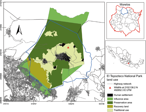
Fig. 1 Urban areas, soil use and location of the wildfire within the study area. Elaborated with information from CONANP (2011).
2.2 PM2.5 and CO emissions
During the first 24 h the wildfire affected 48 ha; after 120 hours of wildfire, 250 ha had been burnt. Figure 2 presents the two affected areas. Emissions were estimated in both of them.

Fig 2 Scenarios of the affected areas for calculating of emissions. The first scenario shows the affected area in red 24 h after the wildfire started. The second scenario, within the orange rectangle, represents the affected zone 120 h after the wildfire started (image extracted from Google Earth and edited).
The wildfire was located 4 km from Tepoztlán and 2 km away from the nearest population center. Emissions of particulate matter with a diameter smaller than 2.5 μm (PM2.5), carbon monoxide (CO) and black carbon (BC) were calculated using Eq. (1).
where Ei represents the emissions of pollutant (i), EFi is the emission factor in grams of pollutant per kilogram of burnt fuel (gi/kg), A is the burnt area (ha), B is the biomass concentration (kg/ha), and C is the burning efficiency.
Emission factors were obtained from Yokelson et al. (2011); the affected area was taken from reports of the Comisión Nacional Forestal (National Forestry Commission) (Conafor, 2016); biomass data and combustion factors were obtained from Bautista et al. (2014), and emissions were calculated considering the most affected type of vegetation, oak forest.
2.3 PM2.5 and CO concentrations
Concentrations of PM2.5 and CO along the dispersion trajectory were calculated using the VSMOKE program (Lavdas, 1996; USDAFS, 2014). This algorithm, written in Fortran 77, computes the dispersion of pollutants emitted in agricultural burn and wildfires by a Gaussian plume analysis to estimate downwind smoke concentrations.
2.4 Population exposure
In order to determine the trajectory of emitted pollutants, reverse trajectories were simulated with the HYSPLIT model (Stein, 2015; Rolph, 2017). The closest population centers to the wildfire are San Juan Tlacotenco and Santo Domingo Ocotitlán, which were evaluated in terms of exposure to pollutants concentrations to find out whether the population’s health was affected or health criteria were met.
4. Results and discussion
3.1 Emissions and pollutants transport
Emissions estimated according to Eq. (1) for both affected areas are shown in Table I. According to column 6, more than 3.5 t of carbon monoxide per hour were emitted in the first 24 h.
Table I Pollutants and parameters used in emission estimates.
| Pollutant | EF (g/kg) | A24 (ha) | B (kg/ha) | C (%) | E24 (Total emissions over 24 hours) (kg) | A120 (ha) | E120 (kg) |
| CO | 88(±19) 1 | 48 | 68 038.9 3 | 30 3 | 86 219 | 250 | 449 056 |
| BC | 0.56 2 | 48 | 68 038.9 3 | 30 3 | 549 | 250 | 2 858 |
| PM2.5 | 4.5 (±1.64) 1 | 48 | 68 038.9 3 | 30 3 | 4 409 | 250 | 22 963 |
EF: emission factor; A24: area affected after 24 h; B: biomass density; C: burning factor; A120: area affected after 120 h; E120: total emissions after 120 h.
According to the simulation with the HYSPLIT software (Stein, 2015; Rolph, 2017), trajectories of the pollutants emitted during the wildfire were advected mainly northwards, reaching the state of Tamaulipas, and southwards to the state of Guerrero (Fig. 3).
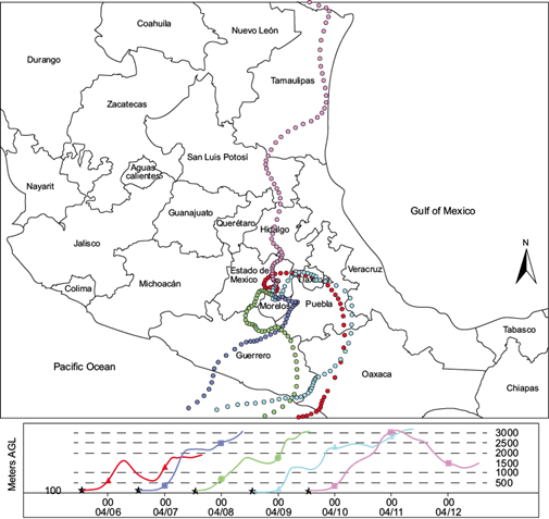
Fig. 3 Dispersion trajectory of the wind plume from April 5, 2016 with the NARR model (NOAA, 2016) from the source located in Tepoztlán, Morelos, Mexico. The northwards and southwards transport of emissions from the wildfire are shown.
A closer analysis of the advective plumes generated with the trajectory model shows that they did not reach the populated city of Cuernavaca, even though several plumes went eastward. Monitoring data of the Cuernavaca station were used to seek whether PM2.5 mass concentration levels increased significantly during the wildfire period; interestingly, it was found that the values of this variable were high both before and after the wildfire, so there is no statistical significance attributable to the fire for the PM2.5 data (Fig. 4).
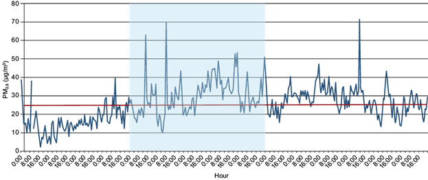
Fig. 4 The PM2.5 mass concentration recorded in the Cuernavaca monitoring station. The period in which the wildfire in Tepoztlán occurred is shown in shaded light blue. The maximum permissible levels according to the World Health Organization (WHO) air quality guidelines (25 μm/m3, 24 h average) (WHO, 2006) is shown in red.
3.2 Population exposure
The VSMOKE software (Lavdas, 1996; USDAFS, 2014) was used to compute PM2.5 concentrations as a function of distance from the wildfire. Figure 5 presents the results from the wildfire simulation starting on April 6 at 17:00 LT. PM2.5 values were above the permissible limits beyond 2 km from the wildfire. The black line shows PM2.5 mass concentrations as a function of distance from the wildfire. It can be seen that the Mexican permissible limit (25 μg/m3) is below the concentration estimated far beyond 3 km from the wildfire.

Fig. 5 PM2.5 concentrations vs. distance from the site of the wildfire. The straight line at 25 μg/m3 is the daily permissible limit stated in the Mexican normativity of air quality. This limit is for a 24 h average and it was established by WHO (2006). The color bars indicate levels established by the USEPA (2014) which represent a risk for human health.
In order to estimate the population exposure to wildfire smoke, it is necessary to estimate how many people are located within the limits of the PM2.5 permissible levels, as shown in Figure 6. The wildfire was initiated in a natural protected area; however, several rural settlements are located in the surroundings. Population-weighted exposure to PM2.5 was obtained from the following equation (Prasannavenkatesh et al., 2015):

where PWEL is the population-weighted exposure level, Pi is the population in the area i, and Ci is the mass concentration of PM2.5 or CO within area i. Figure 6 and Table II show the exposure of the surrounding population to PM2.5 emitted from the wildfire. Santo Domingo Ocotitlán and San Juan Tlacotenco are the towns exposed to pollutants between 1500 and 2000 m from the wildfire.
Table II Population-weighted levels of exposure to PM2.5 and carbon monoxide according to Eq. 2.
| Pollutant | Town | Distance (m) | PWEL |
| PM2.5 | San Juan Tlacotenco | 1500 | 11.4 μg/m3 |
| 2000 | 42 μg/m3 | ||
| Santo Domingo Ocotitlán | 2000 | 44.1 μg/m3 | |
| CO | San Juan Tlacotenco | 1500 | 0.63 ppm |
| 2000 | 2.15 ppm | ||
| Santo Domingo Ocotitlán | 2000 | 2.3 ppm |
In Table II PM2.5 and CO levels from the wildfire in the surrounding settlements are shown. PM2.5 concentrations higher than the WHO daily permissible limit reached San Juan Tlacotenco town, located at 2000 m from the fire and Santo Domingo Ocotitlan town, at 2000 m.
The wildfire at El Tepozteco did not threaten lives and properties because the nearest towns were 2 km upwind. Since the fire developed in a natural protected area, the damage was mainly to the ecosystem. Wildfires contribute to deforestation and might change the composition of forests in ways that are still poorly understood (González et al., 2007). Prescribed fires should be done under a carefully planned scheme from scientific knowledge, e.g., considering the impact to threatened species and minimizing the biodiversity loss (Richards et al., 1999). Furthermore, there is evidence that some ecosystems are not suitable for practicing prescribed fires in the proximity (Pinard et al., 1999).
The prevention of wildfires is an area that evolves worldwide with dynamism and is encouraged to reduce the vulnerability of the population (Ager et al., 2014; Alcasena et al., 2015).
4. Conclusions
The wildfire that occurred in the El Tepozteco National Park from the April 5 to 9, 2016 released a considerable amount of toxic pollutants to the air. An extensive area was burnt, and ecosystems were lost due to a bad practice of agricultural burning. In this case study, pollutant emissions did not directly affect nearby populations; results show that the impact of pollutants concentrations on the community was moderate. However, the wildfire impacted the ecosystem of a protected area to an unknown extent. Future studies should address the severity of the ecological impact of the fire and whether there are any indirect effects on the neighboring populations.
It is necessary to prioritize prevention, monitoring, and mitigation measures of human-induced wildfires in Mexico. It is recommended to increase the coverage of the monitoring network of the government of Morelos to include the Tepoztlán municipality, due to the high frequency of wildfires and the growing urbanization in the zone.

