


Serviços Personalizados
Journal
Artigo
 Inglês (pdf)
 Artigo em XML
 Referências do artigo
 Enviar este artigo por email
Indicadores
-
 Citado por SciELO
 -
 Acessos
Links relacionados
-
 Similares em
SciELO
Similares em
SciELO
Compartilhar

 Permalink
Ciencias marinas
versão impressa ISSN 0185-3880
Cienc. mar vol.29 no.4 Ensenada Out. 2003
Artículos
Nutrient concentrations in coastal waters: Impact of the Guadiana River
Concentraciones de nutrientes en aguas costeras: Impacto del Río Guadiana
A. Cravo1, M. Madureira1, F. Rita1, A.J. Silva2 and M.J. Bebianno1*
1 UCTRA, University of Algarve, Centre of Marine and Environmental Research (CIMA), Campus de Gambelas, 8000-810 Faro, Portugal. *E-mail: mbebian@ualg.pt
2 Hydrographic Institute, Oceanographic Division, Rua das Trinas 49, 1249-093 Lisboa, Portugal.
Recibido en octubre de 2001;
aceptado en noviembre de 2002.
Abstract
Water samples were collected over an area of 900 km2 adjacent to the outflow of the Guadiana River in January 1999 to characterize the concentrations and spatial distribution of nutrients (ammonium, nitrite, nitrate, phosphate and silicate) in the water column. The purpose of the study was to characterize a winter situation of low discharge in terms of nutrient concentrations in the coastal area adjacent to the Guadiana outflow, before the reduction of the river flow due to the completion of the Alqueva Dam. The results show that the maximum influence of the Guadiana outflow was close to the mouth of the Guadiana River, where the highest nutrient concentrations and the minimum of salinity were registered. At the surface, the nutrient concentrations decreased gradually as the distance from the coast increased. The influence of the Guadiana outflow at the surface, despite being small, was evident in the area of about 90 km2 that extends westwards from the mouth of the river. In this area, the increase in N compounds was more significant than in P and Si. The vertical influence of the outflow of the Guadiana River, until over the isobath lower than 30 m, was reflected in nutrient concentrations that decreased with the increase in depth. However, when the depth of the water column was greater than 30 m, the nutrient concentrations increased with the increase in depth. It is expected that with the completion of the Alqueva Dam, the outflow of the Guadiana River will be reduced even further. Nutrient concentrations will also be reduced and the influence of the river in the coastal zone will be even smaller. This could have a negative impact on the nutrient biogeochemical cycles and on the overall productivity of the area.
Key words: nutrients, Guadiana River, coastal waters, Alqueva Dam.
Resumen
En un área de 900 km2 alrededor de la desembocadura del Río Guadiana se recolectaron muestras de agua para caracterizar las concentraciones y distribución espacial de nutrientes (amonio, nitritos, nitratos, fosfatos y silicatos) en la columna de agua. El propósito de este estudio fue caracterizar la condición invernal de pocas descargas, en términos de concentración de nutrientes en el área costera adyacente a la desembocadura del Guadiana, antes de que el flujo del río se vea reducido por la conclusión de la Presa Alqueva. Los resultados indican que la mayor influencia de la descarga del Guadiana se observó cerca de la boca del río, donde se registraron las mayores concentraciones de nutrientes y la salinidad más baja. En superficie, las concentraciones de nutrientes disminuyeron gradualmente con el aumento de la distancia a la costa. La influencia de la descarga del Guadiana en superficie, aunque pequeña, fue evidente en el área de ~90 km2 que se extiende de la boca del río hacia el oeste. En esta área el incremento de compuestos de N fue más significativo que el de los de P y Si. La influencia vertical de la descarga del Río Guadiana, hasta por encima de la isóbata < 30 m se reflejó en las concentraciones de nutrientes que disminuyeron conforme aumentaba la profundidad. Sin embargo, cuando la profundidad de la columna de agua era > 30 m las concentraciones de nutrientes aumentaron con la profundidad. Es de esperar que con la terminación de la Presa Alqueva la descarga del río se vea aún más disminuida. Las concentraciones también se verán reducidas y la influencia del río en la zona costera será aún menor. Esto podría tener un impacto negativo en los ciclos biogeoquímicos de nutrientes y en la productividad global del área.
Palabras clave: nutrientes, Río Guadiana, aguas costeras, Presa Alqueva.
Introduction
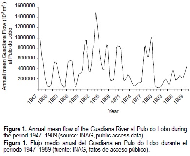
The Guadiana River is the fourth most important river of the Iberian Peninsula. This river, in the southern border between Portugal and Spain, is 810 km long, with a drainage area of about 67,000 km2 of which 17% is Portuguese and 83% is Spanish. The Guadiana River has a very irregular flow, on both seasonal and interannual time scales, associated with climatic conditions and regulation management. The mean annual variability of the Guadiana River flow, at the hydrometric station of Pulo do Lobo (37°48' N, 7°38' W), ca 50 km upstream from the mouth of the Guadiana River, for the period 1947-1989 (historical data from INAG, public access data) is shown in figure 1. During this period, the flow ranged annually from 33 x 106 m3 (1981) to 150 x 107 m3 (1963), and from negligible values in the dry season (September 1954) to about 665 x 107 m3 monthly during flood conditions (January 1970).
Dams restrict the freshwater flow regime and the associated load of suspended particles, having repercussions on the water quality of riverine, estuarine and adjacent coastal waters. One of the possible changes in the water quality is a decrease in the nutrient concentrations (Si, N and P) transported by land drainage and river runoff to the coastal zone. The construction of the Alqueva Dam (with a storage capacity of -4150 hm3 of water) may have a significant impact on the nutrient concentrations of the Guadiana River, its estuary and coastal zone.
Evidence of significant effects in open coastal waters due to damming is sparse (Humborg et al., 1997). However, the extension of the impact of the river outflow on adjacent coastal waters depends upon the variability of the river flow regime and the distance to the mouth of the estuary. It is well documented that areas receiving river discharges have nutrient and phytoplankton concentrations much higher than the adjacent open seas (Cruzado and Velasquez, 1990). Nutrients are the biolimiting elements that play a central role in controlling the primary production and the overall biological productivity of the coastal zones (Libes, 1992). A huge reduction of the freshwater discharge in these areas may cause a decrease in nutrient concentrations (Wetsteyn and Kromkamp, 1994).
In coastal areas directly influenced by estuaries, silicate is one of the nutrients that could show a marked change in its concentration due to the reduction of freshwater flow. Rivers transport to the coastal zones concentrations of silicate one to two orders of magnitude higher than those in seawater (Bien et al., 1958; Banoub and Burton, 1968; Liss and Spencer, 1970; Liss and Pointon, 1973). In the Danube River, after the dam construction a reduction of 70% in silicate was observed, with a concomitant decrease of more than 60% of this nutrient in the coastal area of central Black Sea surface waters (Humborg et al. , 1997). As a result, N:Si and Si:P ratios were distorted, which could be responsible for dramatic shifts in the phytoplankton composition, with species changing from diatoms to non-siliceous species (Justic et al., 1994; Humborg et al., 1997). Thus, dams, to some extent, could affect the biogeochemical cycling of nutrients and the food web structure in coastal areas.
Therefore, in order to assess future alterations on the distribution of nutrient concentrations in the coastal area adjacent to the Guadiana River, associated with the completion of the Alqueva Dam, it is very important to characterize the present situation in winter and summer conditions. So, the objective of the present study was, during winter conditions of low river discharge, to: (1) define the area influenced by the outflow of the Guadiana River, (2) evaluate its interaction with oceanic waters, and (3) study the vertical distribution of the nutrient concentrations in the adjacent continental shelf area directly influenced by the Guadiana River. For this, seawater samples were collected at different depths in winter conditions, in an area where the influence of the Guadiana River impact was expected.
Materials and methods
In January 1999, water samples were collected during an oceanographic cruise on board the R/V N.R.P. Almeida Carvalho. The sampling area (fig. 2) covered a grid of 38 stations, framed by Vila Real Sto Antônio (7.4° W) and Tavira (7.7° W) meridian lines, from the coastline (37.15° N) until the isobath of 500 m (36.85° N). The sampling stations were spaced approximately 2 km from each other.

Water samples were collected at the surface and at different depths using a Rosette equipped with 12 Niskin water bottles. The depth at which samples were collected ranged from about 10 m to approximately 500 m. At the stations where the water column was lower than 100 m, water samples were collected at the surface and bottom. At the stations where the water column was greater than 100 m, an intermediate level of the water column was selected for sampling the water. This depth was defined by the nephelometric signal of a CTD profile and ranged from 60 to 440 m.
Water samples were filtered through 0.45-µm pre-weighed membrane filters and frozen at -20°C prior to the analysis of nutrient concentrations. Ammonium (NH4+), nitrite (NO2-), nitrate (NO3-), phosphate (PO43-) and silicate (SiO44-) were analyzed according to the methods described by Grasshoff et al. (1983), using a Skalar autoanalyser. Ammonium, nitrate and silicate were determined over the range 0.2-15 µM, nitrite over the range 0.02-2.5 µM, and phosphate over the range 0.04-2.5 µM. The Marine Nutrient Standard Kit (OSI) was used as reference material.
Contour mapping of the nutrient concentrations was made based on the calculation of areal integrals by the kriging interpolation method, using the Surfer computer programme.
Results and discussion
Surface and bottom spatial distribution of ammonium, nitrite, nitrate, phosphate and silicate concentrations are presented in figures 3, 4, 5, 6 and 7, respectively. The range of the nutrient concentrations at surface, intermediate depth and bottom are summarized in table 1.


As can be seen from the surface data of ammonium, nitrite, nitrate, phosphate and silicate distribution (figs. 3a, 4a, 5a, 6a, 7a, respectively), the influence of the Guadiana River outflow was small. No plume of reduced salinity was observed in the coastal area associated with the Guadiana outflow. The relative freshwater contribution, calculated from the minimum salinity registered (S = 35.62; Instituto Hidrográfico, 1999a) in relation to the mean salinity of this coastal area (S = 36.30) was about 2%, detected particularly at the surface close to the mouth of the river (station 12, fig. 2). While salinity was minimum, the concentrations of silicate (3.45 µM) and phosphate (0.45 µM) were maximal along with the highest ammonium, nitrite and nitrate concentrations (NH4+ = 6.64 µM, NO2- = 0.56 µM and NO3- = 2.94 µM). The flow recorded at the hydrological station of Pulo do Lobo was small (17 m3 s-1) for this time of the year when compared with the hydrological regime of previous years and with the overall mean value for the period 1947-1989 (-340 and 156 m3 s-1, respectively; table 2). In fact, the mean flow for this time of the year was similar to those observed in summer months (table 2). However, even during winter, the flow of the Guadiana River is very irregular, ranging from 5 m3 s-1 (January 1983) to 2483 m3 s-1 (January 1970).
The ranges of nutrient concentrations obtained in the present work were of the same order of magnitude as those found in the coastal area adjacent to the Guadiana outflow in September and October 1998 (CEDEX, 1998), when the flow was 18-32 m3 s-1 (considered small, typical of summer conditions) and 39-125 m3 s-1 (typical of winter conditions), respectively. With a higher outflow (November 1998), except for ammonium, all the other maximal nutrient concentrations were higher than the ones obtained in this work (tables 1, 3).
The ranges of nutrient concentrations were not significantly different when compared with others obtained in similar flow conditions along the Guadiana estuary (tables 1, 3), particularly in its lower part (-12 km upstream from the mouth), between October 1996 and March 1998 (Chícharo et al., 2001; Rocha et al., 2002; table 3). However, the differences are evident when periods of high flow were compared, as was the case of December 1997 (table 3). Consequently, the nutrient concentrations in this study are typical of the winter months of low river flow discharge.
The preceding data provided valuable "snapshot" information on the magnitude of the nutrient concentrations in the waters adjacent to the Guadiana outflow that could not be representative of the typical winter situation, when flows are expected to be generally higher (table 2). However, as typically found in coastal areas affected by estuarine discharge, a general enrichment in nutrient concentrations was evident at the stations closest to the estuary, those over the 10-m isobath, when compared with other data collected along the south Portuguese coast from areas not directly influenced by freshwater inputs (table 3).
The influence of the Guadiana outflow at the surface, despite being small, was evident in the area of about 90 km2 that extends westwards from the mouth of the river. This area is 15 km long (stations 9 to 19) and 6 km wide. This drift was also observed in the distribution of the surface suspended solids collected at the same time (Instituto Hidrográfico, 1999b). A similar drift to the west was recorded, 20 years ago, at the mouth of the estuary, when a turbid water mass was observed during measurements of physical parameters in the Guadiana estuary and adjacent coastal area (Michel, 1980). Moreover, Almeida (1999), using satellite imagery, observed a surface countercurrent directed to the west parallel to the Algarve coast throughout the year. In this particular area of 90 km2, surface nutrient concentrations were higher than those between the isobaths of 30 to 100 m (figs. 3a, 4a, 5a, 6a, 7a). A comparison of the mean surface nutrient concentrations and the N:P and N:Si ratios in these areas is presented in table 4. A three-fold increase in N compounds (mainly ammonium) was observed in the area of influence of the Guadiana River outflow, whereas the increase in silicate was low (-25%, table 4). During this study, the presence of this surface countercurrent was the major factor affecting the surface nutrient distribution due to the small outflow influence. However, as the Guadiana estuary is very influenced by tide (tidal influence is felt until -50 km upstream from the mouth), those processes associated with tidal fluxes, tidal conditions and regimes must also be taken into account when studies on the distribution of nutrient concentrations are performed around the Guadiana mouth.

During this study, in the area of the Guadiana outflow influence, the N:P and N:Si ratios calculated were 17 and 3, respectively (table 4). These ratios support the assumption that the N compounds were in excess and showed that P and Si were the limiting elements. Surface nutrient concentrations decreased with the increase in distance from the coast. This was observed at stations with a water column depth greater than 30 m where salinity increased, reaching values of 36.4. This is due to the two component mixing system, mixture of freshwater with seawater (Coste et al., 1987; Cruzado and Velasquez, 1990; Lefevre et al., 1997). The N:P and N:Si ratios at the surface decreased from 17 to 7 and from 3 to 1, respectively (table 4), over the isobaths between 30 and 100 m, indicating that in the water mass between those isobaths, N was the limiting element. This is usual in typical marine waters. However, surface nutrient concentrations were generally lower than in the areas over the isobath greater than 100 m. This can indicate that the primary production in that area was more important than in more remote stations. However, the effect of the alteration of the nutrient ratios upon the phytoplankton assemblages was not studied.
One of the major input of nutrients in coastal areas are river discharges (Valiela et al., 1991; Rabalais, 1996); however, the extension of river discharges depends on the volume of water that reaches the coastal zone (variability of the river discharge regime) and on its spread in the coastal zone. Areas that are markedly influenced by river discharges show evident nutrient gradients along with changes in salinity. Nutrient concentrations in these areas are much higher than in the adjacent open seas and decrease as salinity increases, tending to behave conservatively in rapidly flushed estuaries (Balls, 1994). This is particularly evident during winter, when little or no loss of nutrients through phytoplankton consumption was expected, due to their minimal activity (Cruzado and Velasquez, 1990). The conservative mixing of nutrients is a function of the estuarine flushing time that controls the extent to which internal processes (biological and abiotic) can modify nutrient inputs. Significant negative relationships are usually found between nutrient concentrations and salinity in a wide range of salinity, in which nutrient concentrations are higher at lower salinity. In these cases, the nutrient used as the best freshwater tracer is silicate (Hunt and Foster, 1977, 1985). The relationship between surface nutrient concentrations and salinity is presented in figure 8. Significant relationships exist between nutrient concentrations and salinity although the correlation coefficients between variables were relatively low (P < 0.01) (fig. 8). This was attributed partly to the small amplitude of salinity associated with the reduced influence of the Guadiana outflow. However, in this study silicate was not the best tracer to identify the presence of freshwater input. The nutrient that showed the highest conservative behaviour was phosphate (r = -0.71; fig. 8b). Some departure from the theoretical dilution line was observed for those points that were off the regression line, which corresponded to samples in the area directly influenced by the freshwater discharge (stations 12, 13, 14, 15, 19; fig. 2). That possibly resulted from the inherent chemical behaviour of the mixing waters in combination with an in situ non-conservative biological (phytoplankton consumption) behaviour. These relationships are also conditioned by the minimum salinity value (S = 35.6) and consequently they must be interpreted with caution. In fact, if this value is not taken into account, both silicate and ammonium concentrations did not present a conservative behaviour (fig. 8), whereas for the phosphate, nitrite and nitrate concentrations, the correlation coefficients increase with salinity (r = -0.81, r = -0.66 and r = -0.57, respectively). Nevertheless, for more reliable information about the mixture of fresh and marine waters in this area in order to determine the dilution effect upon coastal waters, a wider range of salinity must be covered.
The vertical distribution of nutrient concentrations in the water column with a depth lower than 30 m, showed that concentrations were higher at the surface than at the bottom (figs. 3, 4, 5, 6, 7). This supports the influence of the Guadiana outflow mentioned above. When the water column has a depth greater than 30 m, the nutrient concentrations showed a gradual increase with depth, mainly due to the uptake of nutrients by phytoplankton at the surface and remineralization in the water column (Saad and Hassan, 1994; Vukadin and Stojanoski, 1996; Padmavathi and Satyanarayana, 1999).
With the completion of the dam, an impoverishment in nutrient concentrations in coastal waters will be expected at the surface (due to the decrease of the river discharge). One way that nutrient concentrations can be reestablished is by mixing with the underlying waters, usually richer in nutrients, or during upwelling events. Effectively, in the bottom layers (depths between 400 and 500 m), nutrient concentrations were generally higher (figs. 3b, 4b, 5b, 6b, 7b), particularly nitrite (1.06 µM), phosphate (0.74 µM) and silicate (5.73 µM) (table 1). At these depths, increases in salinity (maximum S = 36.55) and temperature were observed. These high nutrient concentrations cannot be associated with the impact of the Guadiana outflow but probably to the presence of Mediterranean Water (MW), or to a mixture of MW with North Atlantic Central Water (NACW). The presence of MW in this region was previously identified (Âmbar, 1983; Zenk and Armi, 1990; Rhein and Hinrichsen, 1993; Almeida, 1999). Âmbar (1983) detected a shallow core of MW off the southern part of the Iberian Peninsula along the continental shelf break and slope at around 400 m. This water, that leaves the Strait of Gibraltar, coming from the Alboran Sea, is generally rich in nutrients (Minas et al., 1983, 1987, 1988, 1991; Packard et al., 1988). At the intermediate level of the water column (over the isobaths greater than 100 m), some ammonium and nitrate concentrations were higher than at the bottom (table 1). These concentrations were observed at around 300 m, in the upper slope of the continental shelf edge where a turbid plume was observed, associated with a positive thermohaline anomaly. Temperature and salinity characteristics were different from those typical of the NACW and identified as a subsurface filament of MW. This water mass can also be a source of nutrients when those are depleted at the surface.
In this particular winter study, the area of influence of the river outflow was reduced due to the small river discharge associated with dry winter conditions. It is expected that during summer, the Guadiana outflow will be even smaller. Therefore, the completion of the Alqueva Dam will have some effects upon the water quality, namely the alteration of the surface nutrient concentrations. Other chemical characteristics of the coastal waters could also change and, in the future, the area of influence of the river will be even smaller than the 90 km2. This could have an important impact in nutrient biogeochemi-cal cycles and affect the food web structure and the overall productivity of the ecosystem. It will be expected that in summer, if a further restriction of the flow (and nutrients) occurs, the structure of the phytoplankton communities could suffer significant alterations. The dominant phytoplankton species in the study area were dinoflagellates, euglenas and marine diatoms in the marine zone, while in the upper estuary, species were typical of freshwater (CEDEX, 1998). Inside the estuary (between October 1996 and March 1998), the higher phytoplankton density was dominated by chlorophytes and cyanobacteria in the upper estuary during summer. In the middle estuary, the dominant species were nanoflagellates, whereas in the lower estuary, they were diatoms, nanoflagel-lates and marine dinoflagellates (Gouveia et al., 1999; Chicharo et al., 2001; Rocha et al., 2002). To what extent the conclusion of the Alqueva Dam will affect the phytoplankton community structure and the overall primary productivity inside the Guadiana estuary and in the adjacent coastal area must be assessed in future studies.
Acknowledgements
This study was carried out under project SIRIA funded by a joint venture between the Ministry of Defence and the Foundation of the Universities of Portugal in the framework of the Environment and Defence Programme.
References
Almeida, P.J.R. (1999). The physical oceanography of Cape São Vicente upwelling region observed from sea, land and space. Ph.D. thesis, University of Wales, Bangor, 244 pp. [ Links ]
Âmbar, I. (1983). A shallow core of Mediterranean water off western Portugal. Deep-Sea Res., 30: 677-680. [ Links ]
Balls, P.W. (1994). Nutrient inputs to estuaries from nine Scottish east coast rivers: Influence of estuarine processes on inputs to the North Sea. Estuar. Coast. Shelf Sci., 39(4): 329-352. [ Links ]
Banoub, M.W. and Burton, J.D. (1968). The winter distribution of silicate in Southampton water. J. Cons. Permanent Explor. Mer, 32(2): 201-208. [ Links ]
Baptista, A. (1997). Caracterização física e química da massa de água ao longo da costa sul Algarvia: um estudo pontual. Relatório de Estágio do Curso de Licenciatura em Biologia Marinha e Pescas. Universidade do Algarve, Faro, 40 pp. [ Links ]
Bien, G.S., Contois, D.E. and Thomas W.H. (1958). The removal of soluble silica from freshwater entering the sea. Geochim. Cosmochim. Acta, 14: 35-54. [ Links ]
Benoliel, M.J.A.G. (1982). Controle da poluição na Ria de Faro, Jul 78-Dez 79. Rel. 70, Lisbon. [ Links ]
Benoliel, M.J.A.G. (1989). Vigilância da qualidade da água da Ria Formosa, 1981-1984. Rel. TF-QP04/89. Instituto Hidrográfico, Lisbon. [ Links ]
CEDEX (1998). Estudio de variables ambientales en el tramo onubense del Rio Guadiana. Centro de Estudios de Puertos e Costas, clave OECEX 23-997-5-002. [ Links ]
Chicharo, M.A., Chicharo, L.M., Galvão, H., Barbosa, A., Marques, M.H., Andrade, J.P., Esteves, E., Miguel, C. and Gouveia, I. (2001). Status of the Guadiana estuary (South Portugal) during 1996-1998: an ecohydrological approach. Aquat. Ecosys. Health Management, 4: 73-89. [ Links ]
Coste, A., Cadenes, A. and Minas, H.J. (1987). New observations on the eutrophication of the Gulf of Lion due to input by the Rhone River. 2nd Soviet-French Symposium on Production and Trophic Relationships within Marine Ecosystems. Yalta, 27 October to 2 November 1984. Actes Coloq. IFREMER, 5: 39-40. [ Links ]
Cruzado, A. and Velasquez, Z.R. (1990). Nutrients and phytoplankton in the Gulf of Lions, northwestern Mediterranean. Cont. Shelf Res., 10(9-11): 931-942. [ Links ]
Falcão, M.M. (1997). Dinâmica dos nutrientes na Ria Formosa: efeitos da interacção da laguna com as suas interfaces na reciclagem do azoto, fósforo e sílica. Tese de Doutoramento, Universidade do Algarve, 223 pp. [ Links ]
Gouveia, I., Miguel, C., Chícharo, M.A, Marques, M.H. e Chícharo, L.M. (1999). Plancton do estuário do Guadiana: Sazonalidade e relação com os parâmetro ambientais: Resultados preliminares. Rev. Biol., 17(1-4): 179-192. [ Links ]
Grasshoff, K., Ehrhardt, M. and Kremling, K. (1983). Methods of Seawater Analysis. 2nd ed. Verlag Chemie, Kiel, 419 pp. [ Links ]
Humborg, C., Ittekkot, V., Cociasu, A. and Budengen, B.V. (1997). Effect of Danube River dam on Black Sea biogeochemistry and ecosystem structure. Nature, 336(6623):385-388. [ Links ]
Hunt, D.T.E. and Foster, P. (1977). Studies of the mixing of coastal waters in Liverpool bay using dissolved silicate as a tracer. Water Res., 11: 465-470. [ Links ]
Hunt, D.T.E. and Foster, P. (1985). Dissolved silicon in a North Wales catchment of high relief. Water Res., 19(4): 465-470. [ Links ]
Instituto Hidrográfico (1999a). Processamento de dados hidrológicos e nefelométricos recolhidos na campanha SIRIA 99-01. REL TP/ OC/32/99, I.H., Lisbon. [ Links ]
Instituto Hidrográfico (1999b). Progresso dos trabalhos referentes ao primeiro semestre de execução do projecto SIRIA. REL TP/OC/3/ 99, I.H., Lisbon. [ Links ]
Justic, C., Rabalais, N.N. and Turner, R.E. (1994). Riverborne nutrients, hypoxia and coastal ecosystem evolution: Biological responses to long-term changes in nutrient loads carried by the Po and the Mississippi Rivers. In: K.R. Dyer and R.J. Orth (eds.), Changes in Fluxes in Estuaries: Implications from Science to Management. Fredensborg, Denmark, Olsen and Olsen, pp. 161-167. [ Links ]
Lefevre, D., Minas, H.J., Minas, M., Robinson, C., LeB. Williams, P.J. and Woodward, E.M.S. (1997). Review of gross community production, primary production, net community production and dark community respiration in the Gulf of Lions. Deep Sea Res., 44(3-4): 801-832. [ Links ]
Libes, S.M. (1992). An Introduction to Marine Biogeochemistry. John Wiley & Sons, New York, 734 pp. [ Links ]
Liss, P.S. and Spencer, C.P. (1970). Abiological processes in the removal of silicate from sea water. Geochim. Cosmochim. Acta, 34: 1073-1088. [ Links ]
Liss, P.S. and Pointon, M.J. (1973). Removal of dissolved boron and silicon during estuarine mixing of sea and river waters. Geochim. Cosmochim. Acta, 37: 1493-1498. [ Links ]
Michel, D. (1980). Synthese des donnes mesurées dans le Rio Guadiana: Evaluation de l'intrusion dans l'estuaire. Rapport technique concernant la campagne du mois d'Avril 1979 sur le Rio Guadiana. Laboratoire d'Oceanographie de l'Université Libre de Bruxelles. [ Links ]
Minas, H.J., Coste, B., Le-Corre, P., Minas, M., Packard, T.T. and Raimbault, P. (1983). Role of circulation in the Alboran Sea in the vicinity of the Stait of Gibraltar, on the production-regeneration system (MEDIPROD cruise IV of Jean Charcot). Parr. P. V. Reun. CIESM, 28(7): 59-61. [ Links ]
Minas, H.J., Coste, B. and Minas, M. (1987). The vicinity of the Strait of Gibraltar: A source of a permanent high productivity. 2nd Soviet-French Symposium on Production and Trophic Relationships within Marine Ecosystems. Yalta, 27 October to 2 November 1984. Actes Coloq. IFREMER, 5: 40-41. [ Links ]
Minas, H.J., Coste, B., Minas, M., Gostan, J., Nival, P. and Bonin, M.C. (1988). New vs. regenerated production in the northwestern Mediterranean Sea. Oceanol. Acta, 9: 155-162. [ Links ]
Minas, H.J., Coste, B., Le-Corre, P., Minas, M. and Raimbault, P. (1991). Biological and geochemical signatures associated with the water circulation through the Strait of Gibraltar and in the western Alborean Sea. J. Geophysical Res., 95(C5): 8755-8771. [ Links ]
Packard, T.T, Minas, H.J., Coste, B., Martinez, R., Bonin, M.C., Gostan, J. Garfield, P., Christensen, J. and Dortch, Q. (1988). Formation of the Alboran oxygen minimum zone. Deep-Sea Res., 35(7A): 1111-1118. [ Links ]
Padmavathi, D. and Satyanarayana, D. (1999). Distribution of nutrients and major elements in riverine, estuarine and adjoining coastal waters of Godavari, Bay of Bengal. Indian J. Mar. Sci., 28(4): 345-354. [ Links ]
Rabalais, N.N., Wiseman, W.J. Jr., Turner, R.E., Justic, D., Sen-Gupta, B.K. and Dortch, Q. (1996). Nutrient exchanges in the Mississippi River and system responses on the adjacent continental shelf. Estuaries, 19(2B): 396-407. [ Links ]
Rhein, M. and Hinrichsen, H.H. (1993). Modification of Mediterranean Water in the Gulf of Cadiz, studied with hydrographic and chlorofluoromethanes data. Deep-Sea Res., 40: 267-291. [ Links ]
Rocha, C., Galvão, H. and Barbosa, A. (2002). Role of transient silicon limitation in the development of cyanobacteria blooms in the Guadiana estuary, south-western Iberia. Mar. Ecol. Prog. Ser., 228: 35-45. [ Links ]
Saad, M.A.H. and Hassan, E.M. (1994). Distribution of nutrients in the Rosetta estuary of the Nile and the adjoining coastal Mediterranean waters. 37th Conference of the International Association of Great Lakes Research and Estuarine Research Federation, Buffalo, USA, 1994, p. 166. [ Links ]
Valiela, I., Foreman, K., LaMontagne, M., Hersh, D., Costa, J., Peckol, P., DeMeo,-Andreson, B, D'Avanzo, C. and Babione, M. (1991). Couplings of watersheds and coastal waters: Sources and consequences of nutrient enrichment on Waquiot Bay, Massachusetts. Couplings of watersheds and coastal waters. 5th Int. Cong. Of Ecology, INTECOL.15(4): 443-457. [ Links ]
Vukadin, I. and Stojanoski, L. (1996). Mediterranean and Adriatic Sea: Exchange of water and nutrients on the Pelagruza Sill (middle Adriatic). Proc. 2nd International Conference on the Mediterranean Coastal Environment, MEDCOAST 95, Tarragona, Spain. [ Links ]
Wetsteyn, L.P.M.J. and Kromkamp, J.C. (1994). Turbidity, nutrients and phytoplankton primary production in the Oosterschelde (The Netherlands) before, during and after a large-scale coastal engineering project (1980-1990). The Oosterschelde Estuary, The Netherlands: A case study of a changing ecosystem. Vol. 282-283: 61-78. [ Links ]
Zenk, W. and Armi, L. (1990). The complex spreading pattern of Mediterranean Water off the Portuguese continental slope. Deep-Sea Res., 37(12): 1805-1823. [ Links ]

