


 text new page (beta)
 English (pdf)
 Article in xml format
 Article references
 Send this article by e-mail
 Cited by SciELO
  Similars in
SciELO
Similars in
SciELO 
 Permalink
Introduction
The mining and metals sector has major importance for regional and local socioeconomic development, in addition to its influence on global economy in terms of mineral supply and energy resources. Consequently, the most varied waste and environmental liabilities generated by such activity demand a proper management for the benefit of environmental integrity and local communities (Gilmore, 2008; Jain, Cui and Domen, 2016).
The Brazilian Mining Institute (IBRAM) indicates that mineral substances correspond to 14.5% of the country total exportation, represents 52% of exportation trade balance and points to the participation of the mineral extractive sector in 3.7% of Brazil’s Gross Domestic Product (GDP) (IBRAM, 2019).
Although approximately only one third of its territory was prospected, Brazil possesses the world’s sixth largest uranium ore reserves, which amounts approximately 310,000 t of triuranium octoxide (U3O8), recoverable at low cost (Brazil, 2017). All processes concerning uranium and other radioactive elements, such as mining, are national monopoly activities. The Nuclear Industries of Brazil are nowadays regulated by the National Nuclear Energy Commission and the Brazilian Institute of Environment and Renewable Natural Resources, CNEN and IBAMA respectively in Portuguese. Despite of CNEN establishment in 1956, IBAMA was only founded in 1989.
Social and environmental impacts of mining must be an integral part of all mine planning and mineral development from the discovery phase through to closure process, regarding the complexity that involves the mined ore. Physically landscape disturbance is a result of mining, including waste rock and tailings disposal areas and facility development. Operations and waste products associated with metal extraction and processing are one of the main causes of environmental concerns about metal mining, which may increase the acidity of soils and consequent degradation of both surface and groundwater quality, as well as increase air-borne dust and other emissions (Hudson, Fox and Plumlee, 1999).
The exposure of natural reactive minerals to superficial environmental conditions can trigger key processes for the generation of highly complex contaminants. Studied across the globe, metal sulfide minerals are present in host rock associated with most types of metal mining activity. In the presence of moisture and atmospheric oxygen, sulfide minerals are oxidized and generates acid mine drainage (AMD). Although the oxidation of these minerals and the formation of sulfuric acid is a function of natural weathering processes, mining activity, such as extraction and beneficiation operations, increase the chemical reactions by exposing large volumes of sulfide rock material with increased surface area. Among others, pyrite, arsenopyrite, chalcopyrite and chalcocite oxidation can occur for several years following mine closure (USEPA, 1994; Akcil and Koldas, 2006).
Followed by the generation of AMD, secondary factors act to either neutralize the acid produced by oxidation of sulfides or may change the effluent character by adding metals ions mobilized by residual acid. The generation of AMD and the potential to release contaminants are dependent on many factors, including specific characteristics found at different locations, such as climate and physical properties of the waste material. In the geological environment, the occurrence of radioelements associated with sulfide rocks under chemically reducing conditions create an environment where uranium and thorium exist in a tetravalent state, a configuration relatively insoluble. However, under oxidizing conditions uranium occurs in hexavalent uranyl ion (UO2 2+), soluble in water and mobilized by AMD (USEPA, 1994; Dentith and Mudge, 2014).
The radiometric method measures naturally occurring radioactivity in the form of gamma-rays, most originated from mineral species containing radioactive isotopes of potassium, uranium and thorium (40K, 238U, 235U, and 232Th). This study consists in the recognition of shallow mineralized reliquary zones in a waste rock pile of Osamu Utsumi mine, through the geophysical method of gamma-ray spectrometry, allowing its correlation with AMD generation and the radionuclides mobilization. In addition, the comprehension of the superficial drainage infiltration in the waste rock pile and the recognition of main zones of radioactive response will allow the establishment of a suitable management plan to the study area.
Materials and Methods
Study site
In 1982, uranium ore exploration began in Brazil with Poços de Caldas Industrial Mining Complex (CIPC) with a 15 km2 facility in the municipality of Caldas, Minas Gerais State. The CIPC is considered the first installation for uranium ore mining, processing and chemical treatment in the country, based on the exploration of the Osamu Utsumi mine (OUM). In 1995, after producing 1,030 tons of uranium, which corresponds to 24% of the dimensioned potential, OUM was closed due to economic unfeasibility and the decommissioning activity persists until nowadays (Cipriani, 2002). The environment impacts mitigation is a huge dispendious challenge and concern to INB, once the decommissioning plan includes the inactive open pit mine, ore treatment unit, waste rock piles and tailings dam.
The study site is in one of CIPC’s waste rock piles known as BF-04, which is characterized by a predominantly flat area bounded to the north by the by-pass channel of Consulta creek and to the south by the slopes of the upper level of the waste rock pile (Figure 1).
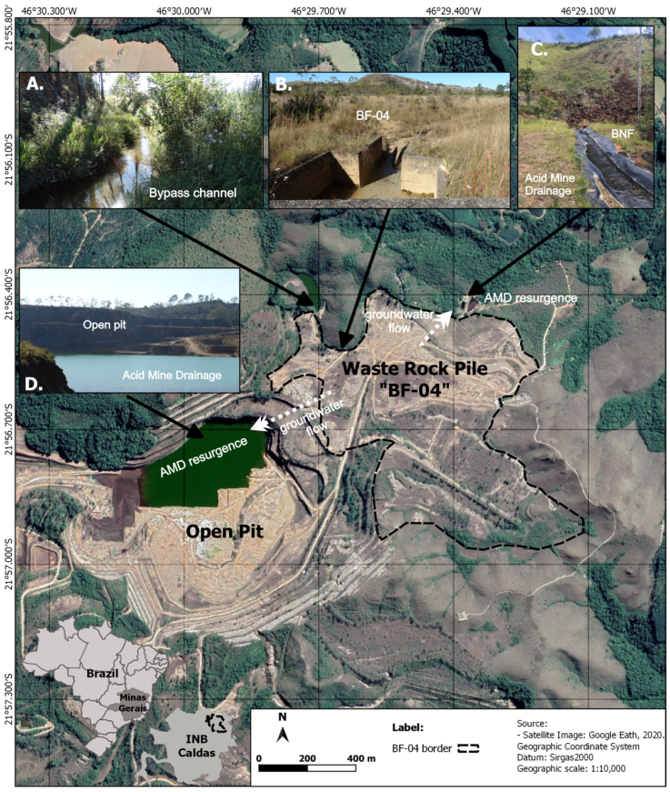
Figure 1 Osamu Utsumi mine location in the INB, Caldas (MG), and delimitation of BF-04 waste-rock pile (A) Bypass channel of Consulta Creek; (B) surface water drainage channel from BF-04 to the Consulta Creek; (C) Nestor Figueiredo Basin (BNF) - catchment of waters affected by acid mine drainage.
Despite of INB efforts to bypass the Consulta Creek and to dispose a layer of clay as a waterproof barrier, it was necessary to build a catchment basin, the BNF, at the base of BF-04 slope to prevent the contamination of the River Verde hydrographic basin (Casagrande, 2019)
The Poços de Caldas Plateau is characterized by its relatively high altitude, which varies from 1300 m to 1600 m, and the tropical climate with two well-defined seasons. The average rainfall index is 1700 mm/ year, having the period between October and March as the months with highest levels of precipitation and milder temperatures are registered, whereas the period from April to September is characterized by strong drought and low temperatures. Rustic grasses form the landscape along with small arboreal patches in the high fields and shrubs along the slopes (Holmes et al., 1992; Cipriani, 2002).
Uranium Deposit Genesis and Waste Rock Pile BF-04 composition
The Alkaline Complex of Poços de Caldas initially suffered regional postmagmatic deuteric and incipient hydrothermal alteration, when occurred potassium metasomatism and zeolitization, with minor argillation under oxidizing conditions and no mobilization/concentration of uranium, thorium or rare earth elements (REEs) (Schorscher and Shea, 1992). In the OUM, mineralized rocks were modified by hydrothermal fluid/rock interaction of local extent, the primary mineralizing event, which led to pyritization, strong potassic metasomatism and to the formation of several radioactive anomalies. Along with subsequent evolutive stages, low-temperature processes formed descending redox fronts associated with supergene uranium remobilization and precipitation (Schorsche and Shea, 1992; Biondi, 2015).
Three different types of ore were explored in the OUM, named “A”, or fluidization breccia, “B” and “E”. With about 60% of uranium reserves, mineralized zone “B” was formed by the hydrothermal alteration in breccias, phonolite and tinguaites lavas. The minerals uraninite, zircon and molybdenum are associated with clay minerals including kaolinite, pyrite and minerals remaining from hydrothermal rocks (Magno Júnior, 1985; Biondi, 2015).
Waste materials from the stripping phase and screening from ore were disposed in the Consulta’s creek and Cercado’s creek valleys without previous waterproofing, forming the waste rock piles BF-04 and BF-08, respectively. BF-04, the focus of this study, has an area of 56.9 hectares and volume of 12,400,000 m3, with waste rock from stripping and screening from ore “B”. After the beginning of OUM operations, one by-pass channel for the Consulta Creek was built with no appropriate waterproof structure (Amaral et al., 1988; Fernandes et al., 1995; Cipriani, 2002; Nóbrega, Lima and Leite, 2008).
BF-04 was built according to the end-dumping method and disposed on the top of a fractured aquifer system. Local potassic rocks, clay and blocks provided by uranium explorations composes the waste rock pile, the main mineralogical composition consists of K-feldspar (50%), Kaolinite (20%), Muscovite (20%) and Pirite (2%), between others (Franklin, 2007; Casagrande et al., 2020).
Even though BF-04 configures an artificial structure, the material works as a phreatic aquifer, vulnerable to local climate conditions. In addition, it is notable the evidence of particles segregation along the pile caused by the construction method based on gravitational process. Thus, the presence of compacted layers and fine-grain material accumulation tend to create saturated zones, once hydraulic conductivity is proportional to the average grain size of the material that composes the hydrogeological system (Casagrande et al., 2020). The waste rock pile structure allows water infiltration and storage at the base of the pile, improving sulfide and water interaction due to high hydraulic conductivity generated by the accumulation of large particles. This context comprises a good environment for DAM formation and spreading (Nóbrega, Lima and Leite, 2008).
Groundwater historical chemical analysis collected in the open pit and in the AMD resurgence shows K-Fe-SO4 as chemical components, acid pH and saline effluents (Table 1). Iron and sulfate high concentrations associated with acid effluents collected in subsurface wells indicates pyrite oxidation by meteoric water. AMD is responsible for mineral leaching, such as fluorite and uraninite, that explains fluorine, iron, uranium and sulfate in the groundwater. Zinc associated with fluorite and low pH are related with sphalerite oxidation associated with mineralized ore combined with pyrite. Divergent sulfate concentrations in underground flow are correlated with a complex patter of AMD generation in sulfide mineralized zones (Nordstorm et al., 1992; Campos et al., 2011).
Table 1 Groundwater chemical analysis
| Open Pit | AMD resurgence | ||
|---|---|---|---|
| Parameter | Nordstrom et al. (1992) | Campos et al. (2011) | Campos et al. (2011) |
| pH | 3,37/3,29(3) | 3,37 ± 0,40 | 3,47 ± 0,11 |
| Eh (mV) | 627 | 525,10 ± 53,39 | 466,98 ± 18,55 |
| K (mg/L) | 37,7 | ... | ... |
| Fe(II) (mg/L) | 50,5 | 0,25 ± 0,24 | 1,89 ± 3,74 |
| Fe (total) (mg/L) | 53,5 | 5,18 ± 3,55 | 1,43 ± 0,91 |
| Al (mg/L) | 98 | ... | ... |
| Mn (mg/L) | 46 | 88,42 ± 16,31 | 89,63 ± 34,23 |
| Zn (mg/L) | 12,8 | 12,65 ± 4,78 | 14,47 ± 6,73 |
| SO4 (mg/L) | 1200 | 1410 ± 241,87 6035,17 | 778,68 ± 661,91 |
| F (mg/L) | 14,9 | 25,73 ±7,55 | 33,60 ± 19,50 |
| U | - | 4,02 ± 1,97 | 8,11 ± 4,24 |
| Th | - | 0,19 ± 0,07 | 0,19 ± 0,13 |
Gamma-ray spectrometry
Gamma-ray spectrometry is a radiometric geophysical passive method which quantifies occurrence of radioactivity through emission of gamma rays of several naturally occurring or artificial radionuclides. Among the group of natural occurrences are those of cosmogenic origin (14C, 3H, 36Cl, etc.) and the ones associated to the geological environment (40K, 235U, 238U, e 232Th), both groups widely known by the acronym NORM (Naturally Occurring Radioactive Materials).
Spectrometry has a distinctive advantage which is the capacity to provide information about the geochemical nature of the radioactive source (Dentith and Mudge, 2014). Spectrometers are sensible to the energies of the radioelements of geological interest, once it can be chosen K, U and Th energy windows to detect energetic ɣ-rays emitted from relevant elements in parts of the energy spectrum where emissions from other elements are weak or rare.
Important in several areas in Geosciences as petrology, hydrochemistry and environment geology (Dentith and Mudge, 2014; Gilmore, 2008; Milson, 2003), 235U, 238U, e 232Th are the first terms of long decay chains, developing several radionuclides until a stable isotope of Pb. On the opposite direction, 40K decays directly to one of his two stable isotopes: 40Ca and 40Ar, this last one through electronic capture with emission of associated gamma-ray of 1461 keV (Chu et al., 1999).
The use of photopics generated by daughter nuclides is a very common approach in gamma-ray spectrometry to determinate the respective primordial parent radionuclide. Thus, the photopeaks of 1765 keV (214Bi) and 2615 keV (208Tl) accounted to estimate concentrations of U and Th, respectively (Erdi-Krausz et al., 2003). When measurement infers indirectly the concentration of the parent, by relating the emission products from daughter element, the concentration of the ɣ-emitting element must be in proportion to the concentration of its radioactive source, meaning the decay series must be in equilibrium (Dentith and Mudge, 2014).
The method can be used through portable or airbone detection systems or profiling probes (Telford, 1990; Ferronsky, 2015). Regarding portable systems, gamma-ray spectrometry, internal memories can store a large quantity of data acquired, which are generally restricted to measurements in the K, U and Th energy windows, and the total (Dentith and Mudge, 2014). Nevertheless, it has some limitations associated with the equipment and environmental conditions: spectral of the detection crystal (scintillometer), topographical irregularities, soil moisture and soil/rock density (Musset and Khan, 2000; Milson, 2003; Beamish, 2015). Thereby, depth of acquisition is an important factor for both planning and analysis procedures because, according to Taylor et al. (2002), approximately 90% of gamma rays observed on surface are generated only in the superficial 30 cm depth in a relatively dry soil of 1.6 g/cm3.
Gamma-ray spectrometry presents a high applicability in determination of environmental gamma radiation levels, especially for its potential correlation with anthropogenic contamination sources (Dentith and Mudge, 2014; Gilmore, 2008).
Data acquisition and processing
Geophysical acquisition was performed through 281 individual points covering the BF-04 most affected area. The system used was the portable RS-332 Multipurpose Gamma-Ray Spectormeter System from Radiation Solutions INC, presenting high sensibility, thermic protection, easy handling, internal GPS, and a collimator associated to the BGO crystal. This equipment enables registration of energetic intermissions from 30 keV to 3,000 keV, an appropriate energy interval for the recognition of daughters radionuclides of series of 232Th, 238U, and the decay of 40K. Finally, the system automatically converts the unit counting-per-second (cps) in concentrations expressed in parts per million (ppm) for U e Th and percentage (%) for K. The generated data for uranium and thorium are given by the term “equivalent” (eU and eTh) due to indirect estimates base on daughter radio-nuclides (IAEA, 2003).
The portable RS-332 Multipurpose Gamma-Ray Spectormeter enables gamma acquisition time sets in 120, 180, 240 and 300 seconds. This is a very relevant factor because it is inversely proportional to the associated reading error (Hendriks et al., 2001) and, according to Løvborg and Mose (1987), in situ gamma acquisitions have used reading periods varying from 1 to 20 minutes. Comparatively, Nardy et al (2014) defined a reading time of 60 seconds for acquisitions also using a bismuth germanate (BGO) scintillometer detector, applied in the analysis of gamma-ray signature in volcanic rocks of Paraná Basin.
With the purpose to understand the correlation of different acquisition times and the variance of measured concentration by a portable gamma-ray spectrometer, four experimental data acquisition in the same spot in the study area were collected. Standard deviation and the coefficient of variation were calculated to be determined the optimal time of data acquisition. Results of coefficient of variation were 1.59% for K and Th, 0.92% for U and 0.56% for dose rate. Minimal variations, such as the measured, permitted the time sets in 120 seconds without changing the consistency and representativeness of the data.
Approximately 28.16 ha of the BF-04 were screened by the individual gamma-ray readings, which were made in direct contact with the surface of the waste rock exposed, without any vegetal cover or soil. The acquisition was concentrated on the average altitude of 1378 m, comprising many portions of BF-04, such as the margins of the Consulta Creek, north border and central region of the waste rock pile. Collecting points were disposed approximately along parallel lines according to NE-SW direction, with average spacing of 30 m (Figure 2).
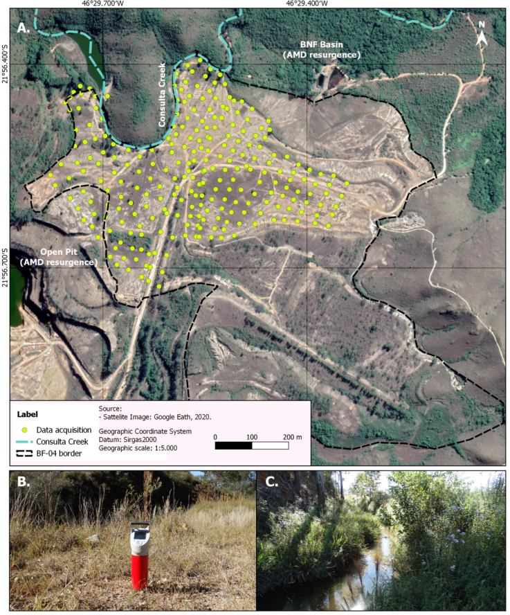
Figure 2 Disposal of geophysical acquisition along the lower level of BF-04. (A) Data acquisition points; (B) RS-332 Multipurpose Gamma-Ray Spectrometer System (Radiation Solutions INC); (C) Consulta Creek.
After acquisition of radiometric data, a processing procedure was performed for generation of maps that reflect radiometric distribution and signature of BF-04 regarding eU, eTh and K.
The 281 collected data points were submitted to an interpolation routine at Oasis Montai platform (Geosoft) in order to generate a bidimensional section of thorium, potassium and uranium concentration values in terms of distance. Due to natural mitigation of gamma rays and receptor capability to recognize energy emitted next to surface, the radiometric data were not deeply processed.
Interpolation is represented through data mitigation from mathematical method of least squares approximation and mitigates de differences of values calculated by the software and values measured on field. Software’s routine consists of automatic creation of a theoretical bidimensional model through division of subsurface in rectangular blocks. Distribution and size of the blocks are automatically created by the program, through distribution of de data points as approximated guidance (Targa, 2020 apud Loke, 2003). Concentrations are calculated by the program from blocks’ model were comparison between measured and patterned values is made. Parameters of the blocks are interactively adjusted until calculated apparent value is accordant to values measured on field.
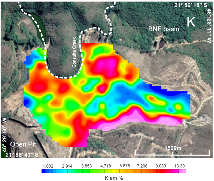
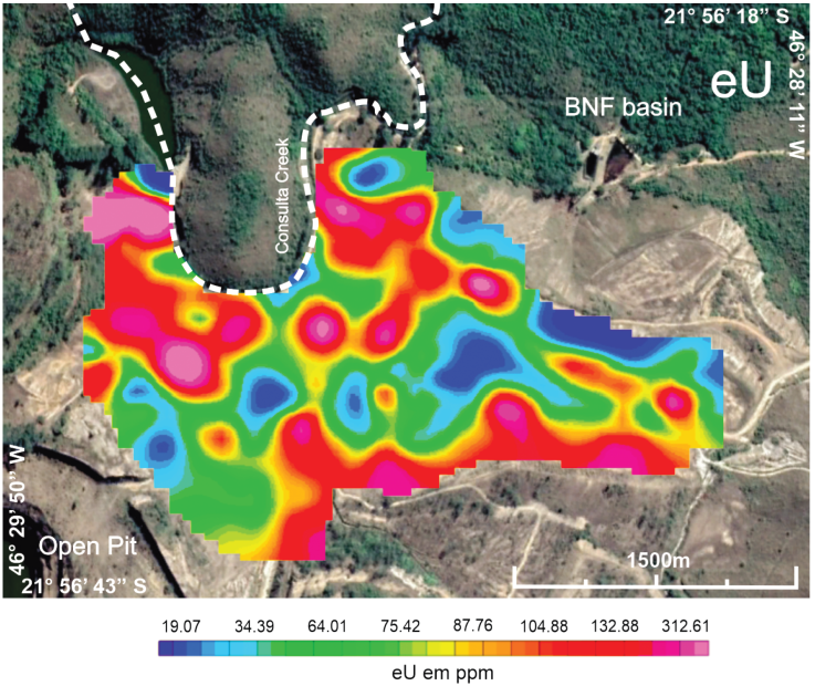
After processing, maps with color-scale or grey-scale are created, representing quantitative contents of elements K (in %), eU and eTh (both in ppm) (Ulbrich et al., 2007). With the processed geophysical data, maps for analysis of radioisotopes are individually prepared.
Results and discussion
The interpretation of radiometric data presumes that anomalous concentrations of one or more radioelements may potentially indicate mineralizing environments (Dentith and Mudge, 2014). However, the possibility of disequilibrium must be a primary consideration. Inferred amount of eU, or eTh concentrations may be too high or too low when disequilibrium occurs, depending on the removal or accumulation of the mobile component of the relevant decay series, and, through the solubility of Ra and mobility of Rn, which can produce 214Bi in locations remote from the parent 238U. The disequilibrium for uranium exploration is most likely to occur on groundwater discharge areas, reducing environments such swamps and situations with increased porosity by physical weathering (Dentith and Mudge, 2014 apud Levinson and Coetzee 1978). Nevertheless, the structure of waste rock pile of the Osamu Utsumi mine allows infiltration and storage at the base of the pile, due to its construction method based on gravitational process (Casagrande et al., 2020). For this reason, the environmental complexity of the BF-04’s superficial recharging zone is entirely distinct from areas where radiometric disequilibrium occurs.
Geophysical data interpolation allows the acknowledgement of radiometric anomalies on the BF-04 surface. The radioelements uranium, thorium and potassium mobility were described, as well as the radiometric characteristics of the waste rock pile BF-04 from the Osamu Utsumi mine.
In distinct environment conditions, potassium has a high mobility and geochemistry solubility. In tropical and subtropical climate zones the decomposition of many potassium minerals due to weathering can be clearly observed (Dentith and Mudge, 2014). The elevated annual pluviosity at Poços de Caldas plateau is the main responsible factor for weathering processes, mainly in superficial and exposed potassic rocks, as identified in the BF-04.
Regarding potassium radiometric response, high concentrations can be associated with the following factors: unchanged potassic rocks, potassium precipitation in wetlands and/or adsorption by clay minerals. On the other hand, low concentrations suggest depletion and element mobility due to weathering (Dentith and Mudge, 2014).
Potassium anomaly zones (Figure 3) are observed in north and southeast areas of BF-04, with values between 5.68% and 13.39% (warm colors), while in the central portion is characterized by lower concentrations varying between 1.002% and 4.72% (cold colors).
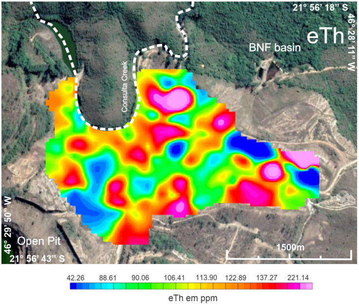
The most important processes associated with uranium and thorium decay are removal, transport, and sedimentation. Uranium (U6+) mobilization occurs in weathering environments and its solubilization is intensified in oxidizing environments due to the formation of the hexavalent uranyl ion (UO2 2+) (Dentith and Mudge, 2014). The main differences between uranium and thorium radioelements mobilization comprise the uranium leaching capacity and thorium detention on organic and inorganic pedogenic substances.
Figure 4 presents a 2D interpolation map of eU and Figure 5 shows the same product for eTh. It is possible to observe similar results in the potassium distribution map, where the highest concentrations of eU and eTh can be found in north and southeast, with eU ranging from 87.76 ppm to 312.61 ppm and eTh between 113.90 ppm and 221.14 ppm.
Casagrande et al. (2020) performed a geophysical investigation through DC resistivity measurements for the same study site, recognizing underground saline flows associated with AMD. Those results were compared to high chargeability anomalies generated by induced polarization method (IP method), that were considered as sulfides accumulation associated with resistive minerals from the rock basement, given its proximity to the open pit area, and, consequently, to reliquary mineralized bodies. The acknowledge of oxidized and reduced zones associated with the generation of acid drainage due to pyrite oxidation were also correlated with previous hydrochemical analysis which present radionuclides and solubilized metals.
Nascimento et al. (2022) presents water infiltration from non-impermeable by-pass channel of the Consulta creek as one of the main key processes that generate AMD in the waste rock pile BF-04, due to chemical interaction between water and sulfide minerals. High concentrations of uranium next to the channel is recognized in this study, making possible the assumption of high uranium radioactivity, due to oxidizing zone, as a radioactive marker of acid drainage.
Figure 6 presents the by-pass channel of the Consulta creek, the most probable responsible for water infiltration in the waste rock pile BF-04 and the generation of acid mine drainage in the north region of the BF-04, with a remnant sulfide rock testimony correlated to a high uranium anomaly.

Conclusions
The loss of biodiversity and natural resources, soil and water contamination, socio-environmental impacts are some of the results of unplanned mining installation and operation. Regarding contamination, AMD associated with mobilized metals and radioelements comprises a specific long-term environmental impact with high technical complexity. Gamma-ray spectrometry, a passive and local investigation, proved to be a relevant contributor for studies of planning and remediation of degraded areas.
Geophysical investigations have an elevated potential for application in environmental studies, so that the radiometric results provided a very useful shallow analysis of contamination caused by AMD in a waste rock pile. The recognition of anomalies characterized by high concentrations of radioactive elements in parallel to sulfide-rich zones and acid drainage generation provided a better understanding and characterization of BF-04.
The mineralized uranium ore includes sulfides that are rapidly destroyed by surface hydration conditions and are responsible for generating acid mine drainage. In this sense, superficial zones in the waste rock pile with high levels of eU and eTh are areas exposed to oxidation and hydration of sulfides, and, therefore, their recognition and neutralization can contribute to decrease AMD generation in the study site and areas with similar characteristics, even indirectly by gamma-ray spectrometry.
The results obtained can be used as support for decisions involving the applicability of in situ remediation solutions with focus to prevent the generation and continuity of contaminated groundwater flows. Correlated to the generation of acid mine drainage by chemical action of surface drainage with sulfide zones, waterproofing actions on the BF-04 surface and installation of an efficient rainwater drainage system are deeply recommended.
Another critical necessity is a waterproof system along Consulta creek channel in order to extinguish or diminish the water infiltration into the waste rock pile. Those combined actions should significantly reduce the generation of AMD captured in the BNF, once the source of water is controlled.
This study complements a series of geophysical investigations that demonstrate the versatility of passive methods in the acknowledgement of environmental impact complexity, in addition to support the planning of sustainable remediation and decommissioning actions in the mining project studied, serving as a model for similar areas.

