


 text new page (beta)
 English (pdf)
 Article in xml format
 Article references
 Send this article by e-mail
 Cited by SciELO
  Similars in
SciELO
Similars in
SciELO 
 Permalink
Introduction
Seismic risk (SR) is the probability that social or economic consequences of earthquakes will be equal to, or exceed, specified values at a site, a several sites, or in an area, during a specified exposure time (EERI Committee on Seismic Risk, 1984). The size of SR is constrained by the convolution of two parameters: the seismic hazard (SH), and seismic vulnerability (SV). The SH is defined as a property of an earthquake that can cause damage and loss (McGuire, 2004). The SV is the probabilistic value of damage in the structure for possible earthquake intensities (Caicedo et al., 1996). Therefore, SH describes the natural phenomenon, or property, of an earthquake and SV describes the ability of houses to resist this earthquake. Finally, SR describes the probability of financial losses and damage that could be caused by SH depending on the level of SV (Wang, 2009).
The higher SR is expected for the regions of high seismic activity and low quality of housing. Both factors are common for many states throughout the world. At the same time, if the level of seismic activity may be the same for a locality, the quality of housing within the locality may differ significantly.
The new technologies, developed to reduce risk against natural hazards in large modern cities, are expensive and need in continuous instrumental monitoring of strong motions. The deterministic seismic hazard analysis has applications for some significant structures, such as nuclear industry, power plants, large dams, large bridges, etc. Probabilistic seismic hazard analysis is a widely used approach for the determination of seismic design loads for engineering structures (Atkinson, 2004; Petersen et al., 2018). The seismic vulnerability assessment, applied to detect, inventory, and rank the most vulnerable buildings in Northern Eskisehir city, Turkey, illustrates the study of the seismic risk for modern high-rise city (Albayrak et al., 2015). They calculated the Earthquake Risk Score of each reinforced concrete buildings in Northern Eskisehir, and the most dangerous buildings with respect to the expected amount of earthquake damage were identified.
For localities, where the vulnerable low-rise, non-engineered (LRNE) houses represent most residential constructions, these technologies are not acceptable and have no great sense. One-and two-story masonry buildings are common in the rural areas because they require easy workmanship. These buildings are constructed with thick adobe and stone walls and mostly vulnerable to strong ground motions. These structures are constructed with traditional techniques using locally available materials. Nearly no engineering services are used in these buildings. Adobe blocks are produced from local material contains mixed soil with straw and leave dried under the sun. As adobe blocks have low strength, walls of masonry buildings are thick and massive (Maqsood and Schwarz, 2009; Sayin et al., 2013; Yon et al., 2017).
The main problem in estimation of the SR for the localities, representing with the vulnerable LRNE houses in many states of Africa, Asia, and Latin America, consists in a search of an optimal and cheap tool for estimation of the extent of physical damage to property for different type of housing. This does not require the optimal determination of seismic design loads for engineering structures, they have not this type structures. As was noted, for example, in description of the M 7.3 Iran-Iraq border earthquake of 12 November 2017, killing more than 400 people and injuring more than 7,000 (https://www.bbc.com/news/world-middle-east-41972338), many homes in the predominantly Kurdish mountainous area were made of mud bricks and became vulnerable in quakes as large as this. The following points are the most important: estimation of the maximum intensity of earthquake for locality and a probability of the level of damage and of financial losses for each type of LRNE houses in this locality.
Our paper proposes the simplified methodology for seismic risk evaluation (SMSRE) for this type of localities. Then this methodology is applied to the localities of the State of Colima, México characterizing with the LRNE type of residential houses. The microzoning of the seismic risk for these localities is presented together with a probabilistic prognostic of the expected losses during the maximum intensity earthquakes at the localities. This study was realized within the project of preparation of the “Atlas of hazards and risks in the State of Colima” (Atlas…, 2015).
Simplified Methodology of the Seismic Risk Evaluation for the Localities with the LRNE Type of Residential Houses
The methodology is based on evaluation of two main sources of information:
(1) The world-wide catalogs of earthquakes and the catalogs of historical earthquakes.
(2) Visual inspection and classification of the vulnerability level of residential LRNE houses and visual macroseismic inspection of the residential house damage after destructive earthquakes.
The seismic risk analysis within SMsRE is basing on the same convolution of two parameters: the SH and the SV, characteristic for any earthquake source zone (ESZ). The analysis requires characterization of all known earthquake sources that could affect the site, including faults (line fault sources) and areas of seismicity (areal sources). To identify the ESZs, the epicentral maps of earthquakes are plotted, basing on the world-wide and (if any) local catalogs of earthquakes.
The world-wide catalogs of earthquakes, used for mapping of ESZs, are available for events, with a cutoff magnitude > 4.0-4.5, beginning from 1963, when the World-wide Standardized Seismograph Network (now developed in The Global Seismographic Network, https://www.iris.edu/hq/prograMs/gsn; last access in February 2020) was installed (Peterson and Hutt, 2014). They may be found at different sites (e.g., http://quake.geo.berkeley.edu/anss/; last access in January 2020).
Calculation of the Elements of Seismic Hazard Generated by Earthquake Source Zone
As the elements of SH, the following characteristics for each ESZ are used: maximum magnitude of earthquakes occurring within a zone, Mmax; recurrence time of appearance of the maximum magnitude earthquake, t; and the law of earthquake intensity attenuation with distance.
The maximum magnitude, Mmax, is defined as the upper limit of magnitude for a given region. For areal sources, the estimation of the maximum magnitude has traditionally been computed by considering the largest historical earthquake in the source zone and adding some additional value (e.g. half magnitude unit). For fault sources, the maximum magnitude is usually computed based on the fault dimensions (length or area).
The recurrence time, t, for earthquake of magnitude M, is estimated considering the earthquake catalog corresponding to Poisson distribution of events, in which earthquakes occur randomly, with no regard to the time, size or location of any preceding event. As the recurrence model within the Poisson process of earthquake occurrence we use the log-linear Gutenberg-Richter magnitude-frequency relationship
Here N(M) is the cumulative number of earthquakes per year with a magnitude equal to or greater than magnitude M and a and b are constants for the seismic zone. The slope of the magnitude-frequency recurrence line, defined as a b-value, describes the relative abundance of large to smaller shocks. The magnitude-frequency relationship (1) allows to estimate the recurrence time of earthquakes of magnitude M occurring within ESZ.
Considering the earthquakes to be distributed randomly, the probability P[N≥1] of at least one exceedance (N≥1) of a particular earthquake of maximum magnitude Mmax in a period of T years is given by the following expression (Anbazhagan, 2011):
where ( is the average rate of occurrence of the event with considered earthquake magnitude.
The law of earthquake intensity attenuation with distance may be obtained basing on the visual macroseismic inspection of the residential house damage after destructive earthquakes. The earthquake intensity is generally represented by the Modified Mercalli (MM) 12-grade intensity scale (Wood and Neumann, 1931). The standard macroseismic equation has a following form (Musson and Cecic, 2002; Montalvo-Arrieta et al., 2017):
Here M is an earthquake magnitude,
The region of study geographically associates mainly with the province of Sierra Madre del Sur. The rocks forming this mountain chain are Precambrian and Paleozoic metamorphic and associated plutonic bodies, Upper Jurassic-Lower Cretaceous miogeoclinal deposits, and Plio-Quarternary and Tertiary volcanic rocks (de Cserna, 1989). All these rocks formed the firm soils that are good for constructions. They may be considered as high-quality firm rock soils. Only the narrow band of sand along the oceanic coast is unfit for construction use and requires the special foundations and antiseismic design. The sand and alluvial soils are considered as low-quality soft soils. The MM intensities on soft and firm soils differ by as many as 2 or 3; therefore, the difference between the soft and intermediate soil intensities could be equal to one grade.
Classification of the residential masonry buildings in localities with LRNE-type housing may be realized within three types of constructions (Zobin and Ventura-Ramirez, 1998):
Type A, low level of SV. Good quality low-rise buildings constructed with engineering project.
Type B, intermediate level of SV. Low-rise buildings constructed with use of quality materials but without engineering project.
Type C, high level of SV. Low-rise old buildings constructed without engineering project and with use of low-quality materials of adobe and cinder blocks.
The law of earthquake intensity attenuation with distance must be calculated using the intensity values referenced to the intermediate type of masonry and average type of soil.
Taking in account possible difference in macroseismic intensity attenuation during characteristic earthquakes of different source zones, a multi scenario assessment of the law (3) may be expected.
Evaluation of the Seismic Vulnerability of the Localities with LRNE Buildings
Seismic vulnerability is defined by a degree of damage that can be suffered by man-made constructions, and it depends on the design, the quality of materials, and the building techniques employed (Kuroiwa, 2004). The evaluation of SV of localities with LRNE-type residential buildings consists in classification of the buildings according to their level of vulnerability, as was mentioned above, and then in classification of the residential blocks that represent the main unit of the urban infrastructure.
The selection of a single building as a unit for a seismic risk assessment is not a practical choice. As it was mentioned in (ATC-13-1, 2002), it is impossible to use the damage probability derived for a class of buildings for a single-building analysis. For a single building, the uncertainty on a damage estimate can be larger than the uncertainty associated with the distribution of expected damage for a group of similar buildings. Therefore, a residential block must be selected as a convenient unit for a zonation of SR.
Evaluation of the Seismic Risk for the Localities with LRNE Buildings
Evaluation of the seismic risk (SR) for any locality in the regions of development of LRNE buildings may be based on the calculation of the damage probability matrix (DPM) for the masonry characteristic for this region. The DPM, introduced by Whitman (1973), expresses the damage, experienced by a particular type of buildings, designed according to some set of requirements, during earthquakes of various intensities. The DPM is a popular tool for estimating losses caused by future earthquakes and is used widely to estimate the potential liability of insurance companies (ATC-13, 1985; Whitman, 1988; Blong, 2003). The DPM represents the expert-opinion motion-damage relationships for different types of buildings calculated for a set of earthquake intensities. The level of damage is described in terms of seven damage states (Whitman, 1988) and corresponding central damage factors, expressed in % (Table 1).
Table 1 The seven-grade scale of damages (based on Whitman, 1988).
| Damage grade | Damage state | Central damage factor (%) | Comments |
|---|---|---|---|
| 1 | None | 0 | No fractures plaster |
| 2 | Slight | 0.5 | Small, not numerous fractures in plaster |
| 3 | Light | 5 | Diagonal fractures in plaster |
| 4 | Moderate | 20 | Narrow closed diagonal cracks in walls |
| 5 | Heavy | 45 | Open diagonal cracks and spalls in walls |
| 6 | Major | 80 | Partly destroyed6construction, con intention to demolish |
| 7 | Destroyed | 100 | Total destruction of the majority of the facility |
Based on the expert-opinion DPM for three types of buildings described above, the probability P of damage for characteristic residential blocks may be calculated in the following way (Zobin and Ventura-Ramírez, 1999; Zobin et al., 2006):
Here p (A, B, and C) is the probability of damage to the masonry of type A, B, and C, respectively, taken from the expert-opinion DPM, calculated for the buildings of a locality; N is the number of buildings of different type; and k (A, B, and C) is a weight coefficient for each type of masonry that form a typical block. Then we construct the DPM_block for each of blocks.
The DPM_block can be used to calculate the probabilistic matrix of the loss costs DPM_cost, which gives us knowledge about the probabilistic losses in housing prices of three types of buildings during earthquakes. To estimate the DPM_cost, is proposed to multiply DPM_block with the matrix consisting of the values of the central factors of damage for each of seven degrees of damage P1-7 corresponding to the percentage of the losses in costs compared with the price of the house before the earthquake:
Here, P7 corresponds to 100% of the losses compared to the price of the home, P6 corresponds to 80% of losses, P5 corresponds to 45% of losses, P4 corresponds to 20% of losses, P3 corresponds to 5% of losses, P2 corresponds to 0.5% of the losses compared to the price of the home, and P1 corresponds to houses without damage.
The microzonation of seismic risk for the locality with proposed Imax is determined by the distribution of three types of residential blocks of different vulnerability. The areas of distribution of the blocks with relatively high quality of buildings are defined as a zone of relatively low risk and the areas of distribution of blocks with relatively low quality of buildings as a zone of relatively high risk. The identification of the level of risk for every zone of locality may be obtained from the DPM_block, characteristic for every zone, by constructing of the probabilistic damage curves corresponding to proposed Imax. The probabilistic matrices of the loss costs DPM_cost, calculated for each zone, allow to estimate the probable losses due to building damage during earthquake.
In the following sections, we apply the described methodology for microzonation of the SR in some municipal centers of the Colima state, México (Fig. 1). This state is characterized by a high presence of the LRNE housing in its localities. We give the general characteristics of the tectonic and seismic activity of the state, mapping of its seismic hazard, and vulnerability assessment. Then, microzonation of the SR within municipal centers of the Colima state will be performed based on the DPM_block’s, estimated for housing of these localities.
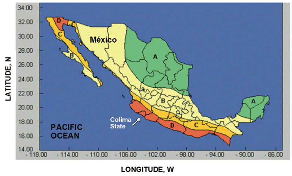
Figure 1 Map of seismic regionalization of Mexican Republic and position of Colima State within this map. Indexes of A, B, C and D indicate zones of different level of expected seismic intensity. Zone A corresponds to the lowest level of expected seismic activity and zone D, to the maximum level of expected seismic intensity. Taken from Manual (1993).
General Characteristics of the Seismo-Tectonic Activity of the State of Colima
The State of Colima, México, selected as a region of study, is located along the Pacific coast, Western México (Fig. 1), and has an area of 5,784 km². Its population is equal to 711,235 persons (INEGI, 2015; http://cuentame.inegi.org.mx/monografias/informacion/col; last access in March 2020). The seismic regionalization of the Mexican Republic, shown in Fig. 1, indicates that the State of Colima is completely situated within zone D, the zone of maximum expected seismic intensity in México (Manual, 1993). The housing in localities of Colima state is characterized by a large percentage (70-80%) of the LRNE buildings (Zobin et al., 2009; 2010).
Catalogs of Earthquakes Used
In this study, the following catalogs of earthquakes are used as a database:
The catalog of earthquakes with magnitudes ≥4.0 recorded in the region of study during the period from 1963 to 2016 and compiled by ANSS (Advanced National Seismic System, North California Earthquake Data Center) http://quake.geo.berkeley.edu/anss/.
The catalog of earthquakes with magnitude M s ≥ 7.0, recorded in the region of study during the period from 1900 to 1990 (Pacheco and Sykes, 1992).
The catalog of local shallow (depth 0-30 km) earthquakes with magnitude ≥4.0, recorded in the continental part of the region of study during 1989-2000 by the seismological network RESCO of the University of Colima (Zobin et al., 2000).
Seismo-Tectonic Environment of the Colima State
Western Mexico represents a complex tectonic zone. The main tectonic elements of this region, the oceanic Rivera and Cocos plates, converge beneath the continental North American plate and produce large destructive earthquakes (Fig. 2). The earthquake epicenters outline the limits of the Rivera plate along the Tamayo (TFZ) and Rivera (RFZ) Fracture zones, East Pacific Rise (EPR) and Middle American trench (MAT), and its boundary with Cocos plate. The limits of the Cocos plate are outlined with the EPR and MAT. The Rivera-Cocos plate boundary zone is a complicated acrosstrench tectonic structure consisting of a few grabens and horsts (Bandy et al., 2005). It runs across the Middle American trench along El Gordo graben (EGG). Earthquakes, associated with activity of the Rivera and Cocos plates and El Gordo graben, represent the earthquake source Zone 1 discussed in this article. Its limits are shown in Fig. 2.

Figure 2 The principal lithospheric plates near the western coast of México and the epicenters of the 1963-2019 earthquakes with magnitudes ≥4.0, compiled by Advanced National Seismic System, North California Earthquake Data Center (http://quake.geo.berkeley.edu/anss/). The epicenters of earthquakes with magnitudes ≥4.0 are shown with diamonds. The stars show the epicenters of large earthquakes (Mw ≥ 7.5) occurring during the period from 1900 to 2016; the events of Table 2 are indicated with numbers. Earthquake source Zone 1 is shown within rectangle. TFZ is Tamayo Fracture zone; RFZ is Rivera Fracture zone; MAT is Middle American trench; EPR is East Pacific rise; CG is Colima graben; EGG is El Gordo graben. The MAT is shown by a dashed line.
During the period from 1900, totally six earthquakes with magnitude M w ≥ 7.5 (Nos 1-4, 7 and 8 in Table 2) were recorded within Zone 1. They occurred along the subduction zones of the Rivera and Cocos plates near Colima state and along the boundary zone between two plates, El Gordo graben. The reported macroseismic effect of these earthquakes reached intensity VII-X MM in the localities of Colima state (Figueroa, 1974; Singh et al., 1985; Zobin and Ventura-Ramírez, 1998; Zobin and Pizano-Silva, 2007).
Two earthquakes of 1985 (Nos 5 and 6 in Table 2), shown in Fig. 2 to SE from Zone 1, were distant enough from Colima state and did not produce any damage in its localities.
Table 2 List of earthquakes with magnitude Mw≥7.5 which occurred during the period from 1900 to 2016 within the area of study (See Fig. 2)
| No | Date, yyyy_mmdd | Latitude, N | Longitude, W | Mw | Ms | Comments |
|---|---|---|---|---|---|---|
| 1 | 1932_0603 | 19.571 | -104.421 | 8.02_1 | 8.02 | Rivera-N_A |
| 2 | 1932_0618 | 18.952 | -104.422 | 7.72_1 | 7.62 | Aftershock of No 1 |
| 3 | 1941_0415 | 18.852 | -102.942 | 7.62_1 | 7.52 | Cocos-N_A |
| 4 | 1973_0130 | 18.392 | -103.212 | 7.62_1 | 7.32 | Cocos-N_A |
| 5 | 1985_0919 | 18.142 | -102.712 | 8.02_1 | 8.12 | Cocos-N_A |
| 6 | 1985_0921 | 17.822 | -101.672 | 7.72_1 | 7.62 | Aftershock of No 5 |
| 7 | 1995_1009 | 18.813 | -104.543 | 8.04 | 7.34 | Rivera-N_A |
| 8 | 2003_0121 | 18.795 | -104.135 | 7.54 | 7.64 | Rivera-Cocos |
Note. 1, Eissler and McNally, 1984; 2, Pacheco and Sykes (1992); 2_1, magnitudes Mw calculated from seismic moments taken from Pacheco and Sykes (1992); 3, RESCO (Zobin, 1997); 4, Global CMT, http://www.globalcmt.org; 5, RESCO (Zobin and Pizano-Silva, 2007). N_A, North American plate. In comments, the plates, along which the rupturing occurred, are indicated.
In the continental part, the seismicity occurs along the boundaries of the block of Jalisco, represented by the grabens of Tepic-Zacoalco and of Colima (Fig. 3). The important element of tectonic activity of the Jalisco block represents also the 160-km-length Tamazula fault, which goes parallel to Colima graben and then intersects it at surroundings of Volcán de Colima (Garduño-Monroy et al., 1998). The active crustal deformation along the Jalisco block boundary faults serves as the origin of seismicity in the continental part of Western Mexico (Suárez et al., 1994; Suter, 2015). Earthquakes, associated with activity of these tectonic faults, represent the earthquake source Zone 2 discussed in this article. Its limits are shown in Fig. 3.

Figure 3 The principal tectonic structures of continental part of the Western México and epicenters of the crustal earthquakes with magnitudes ≥4.0 recorded during 1988-2000 by the seismic network RESCO of Colima University (Zobin et al., 2000). Earthquake source Zone 2 is shown within rectangle. The epicenter of the earthquake of 6 March 2000 (Mw 5.3) is shown with a diamond; the epicenters of its aftershocks are shown with crosses. Positions of Colima city and of Volcán de Colima are shown with triangle and star, respectively.
The largest historical earthquake along the Jalisco block northern boundaries was recorded in December 1567 (or 1568) along the fault system of the Tepic-Zacoalco graben. A 70-km zone of destructions, whose descriptions correspond to intensity IX MM (Suárez et al., 1994; Suter, 2015), is shown in Fig. 3. Suter (2015) estimates the magnitude of this earthquake equal to Mw 7.2.
Recent local seismicity of the Colima sector of the Jalisco block, recorded after installation of the regional seismic network in 1989 (Castellanos y Jiménez, 1995), occurs mainly along the Tamazula fault and Colima graben. The largest earthquake was recorded on 6 March 2000. It had magnitude Mw 5.3 and was felt in Colima state with intensity MM III-V (Zobin et al., 2000).
Seismic Hazard of Colima State
Seismic hazard for localities of Colima state is conditioned by seismo-tectonic activity within two main zones of earthquake source generation, shown in Figs. 2 and 3 and discussed in Section of General characteristics of the seismo-tectonic activity of the State of Colima. In the following sections, three main parameters of the SH, the maximum magnitude Mmax, the earthquake recurrence time t, and the law of seismic intensity attenuation with distance will be estimated for both zones.
Seismic Hazard of Earthquakes Originated within Zone 1
Zone 1 is outlined in Fig. 2. The rupture areas of 6 large earthquakes with M w ≥ 7.5, recorded within Zone 1 during the last 120 years and strongly felt in the State of Colima, are included within this Zone. Five of these large earthquakes occurred along the MAT during the subduction of the Rivera (Events Nos 1, 2 and 7 in Table 2) and Cocos (Events Nos 3 and 4) plates beneath the North American plate. The 2003 earthquake (No 8), also recorded within Zone 1, occurred along the border between the Rivera and Cocos plates within El Gordo Graben. We use the terms “along-trench” and “across-trench” to discriminate between earthquakes whose source ruptures developed in a direction parallel to the MAT or normal to it, respectively. This type of orientation may be traced by aftershock distribution or with reconstruction of the co-seismic slip within the rupture plane.
Maximum Magnitude MMax
To estimate the maximum magnitude of earthquakes, occurring within Zone 1, we analyze the magnitudes of large earthquakes recorded during the period of 1900-2016 in the area (Table 2). Five of the six Mw ≥ 7.5 earthquakes of Zone 1, listed in Table 2, are individual events, and one, No. 2, is aftershock of the No. 1 event.
Two of five individual events, which occurred within Zone 1 during the period of about 120 years (Nos 1 and 7), had the magnitudes Ms or Mw equal to 8.0, respectively. The magnitude 8.0±0.5 may be taken as the magnitude Mmax of the earthquakes from Zone 1.
Earthquake Recurrence Time
The relationship between the number of earthquakes, registered within Zone 1 during the period from 1963 to 2016, and their magnitudes is shown in Fig. 4A. The relationship is based on 524 events that occurred during the period from 1963 to 2016 at the depth interval of 0-100 km with magnitudes ≥4.0 (for events with magnitudes ≥6, only magnitudes Mw were used). The distribution of the cumulative numbers, N, of earthquakes per year, with magnitude greater than M, against their magnitudes M is linear with a correlation coefficient R = -0.995. The least square linear regression equation is
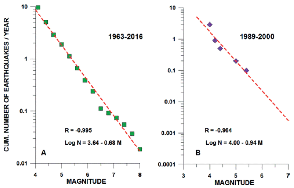
Figure 4 Relationship between the cumulative numbers of earthquakes recorded in Zone I (A) and Zone II (B) and their magnitudes.
Equation (6) gives an option to estimate the annual rate of occurrence of earthquakes with the magnitude M 8.0 equal to 0.017. The recurrence period of earthquakes with magnitude Mmax 8.0 in Zone 1 is equal to 60 years.
Considering the earthquakes to be distributed randomly, the probability of at least one exeedance of a maximum magnitude Mmax earthquake in Zone 1 during the period of T=50 years after the last Mw 8.0 earthquake of 1995, given by the equation (2) in Section 2.1, is equal to 58%.
Attenuation of Earthquake Intensity with Distance
In this section, we significantly deviate from the standard PSHA method which operates for the study of attenuation of earthquake intensity with distance with the curves of attenuation of instrumentally recorded ground motions or spectral accelerations (McGuire, 2004). The main reason for this deviation is the practical absence of the instrumentally recorded strong motions of the Mw ≥ 7.5 earthquakes occurring within Zone 1. Only two acceleration records were obtained at the same site, in Manzanillo, for two earthquakes, of 1995 (No 7 in Table 2) and 2003 (No 8 in Table 2). Tejeda-Jácome and Chávez-García (2007) collected the acceleration records for 26 local Colima earthquakes but with magnitudes in the range of 3.3 < M < 5.2. It gave them possibility to construct the attenuation curve for the magnitude 5 earthquake. In this situation, no data to construct the instrumentally based curves for large (Mw ≥ 7.5) earthquake intensity attenuation with distance for the Colima state region were acceptable. The PGA attenuation curves, obtained in other regions can not be applied. As was shown by Tejeda-Jácome and Chávez-García (2007), the use of attenuation relations, derived with the data from other subduction regions, may underestimate the seismic hazard for Colima. Thus, this study uses only the macroseismic intensity, I, as a parameter for performing of attenuation curves for large earthquakes.
The intensity values of the 1932, 1941 and 1973 large earthquakes (Nos 1, 3 and 4 in Table 2) were derived from newspaper reports (1932 event, Singh et al., 1985) or from newspaper reports and questionnaires obtained by mail and from municipal reports (1941 and 1973 events; Figueroa, 1974). As usual, this type of information dominated by the impressive destructive effects, observed for the LRNE-type buildings, and there was a high probability of over-estimation of the real intensity for the localities. At the same time, the shapes of the outer isoseismals (over-estimated or not), proposed by the mentioned authors, were not so dependent on the methodology and may show the general tendencies in intensity distribution (Fig. 5). All three earthquakes were characterized by the outer isoseismals of maximum intensity extended along the coast and parallel to the direction of the Middle American trench (along-trench events).
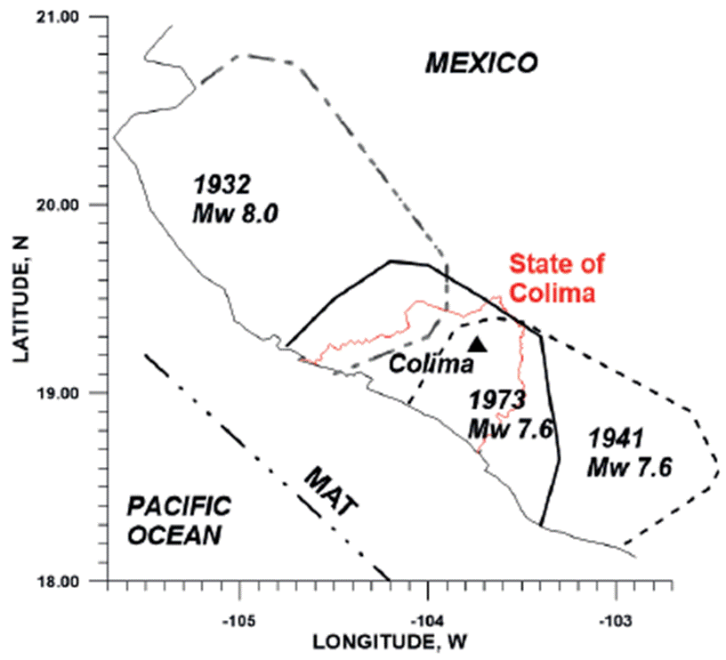
Figure 5 Isoseismals of maximum intensities estimated for large earthquakes of 1932, 1941 and 1973 (Nos. 1, 3, and 4 of Table 2, respectively). Colima city is shown with triangle. The borders of Colima state are shown with red line.
The intensity field for more recent earthquakes of 1995 and 2003 was reconstructed using the information, obtained during the personal interviews of the people who felt the earthquakes in their house, and with the inspection of type of masonry and quality of construction of the house. The questionnaires were based on the MM 12-grade scale. To avoid the effect of poor quality of rural constructions, the estimations of intensity were referenced to the type B masonry. In the case of absent of this type masonry, the corrections of intensity for the type and age of buildings were applied: +0.5 MM intensity for type A masonry and -0.5 MM for type C masonry. If the construction was older than 20 years, its category of masonry was decreased by one grade (from A to B, from B to C) (Zobin and Ventura-Ramírez, 1998; Zobin and Pizano-Silva, 2007).
Figs. 6 (A, B) show the isoseismal maps for these events together with the isolines of co-seismic slip within the rupture plane. In the case of the Mw 8.0 October 9, 1995, along-trench earthquake (Fig. 6A), totally 56 localities were inspected (Zobin and Ventura-Ramírez, 1998). Zones of maximum intensities (MM VI-VII), as well as the direction of co-seismic slip, were observed along the coastal zone parallel to the MAT.
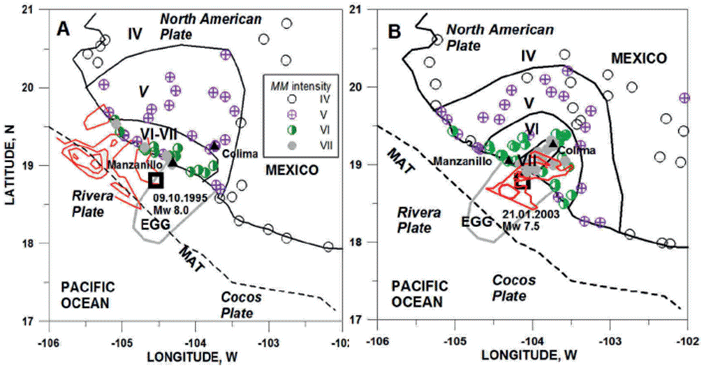
Figure 6 The earthquake intensity patterns observed during the large earthquakes of 9 October 1995 (Mw 8.0) (A) and 21 January 2003 (Mw 7.5) (B). The isolines of co-seismic slip within the rupture plane are shown with red lines (for the 1995 event, according to Mendoza and Hartzell (1999); for the 2003 event, according to Yagi et al. (2004). IV-VII are the Modified Mercalli (MM) intensities. Open squares show the epicenters of two large earthquakes of 1995 and 2003 located by the Colima regional seismic network RESCO. The cities of Colima and Manzanillo are shown by triangles.
The macroseismic study of the Mw 7.5 January 21, 2003, across-trench earthquake was performed for 83 localities (Zobin and Pizano-Silva, 2007). The macroseismic map of the 2003 earthquake (Fig. 6B) shows that the narrow (30 km wide) MM VII zone was elongated (up to 60 km) in the across-trench direction towards the continental part of Colima state coinciding with the direction of co-seismic slip.
The specific features of intensity patterns caused by the difference in rupture directivity do not allow calculating the MM intensity attenuation simply by taking all intensity observations. To have a homogeneous set of data, we took as our basis for calculating of the attenuation law only those observations obtained for the same localities for both earthquakes with differences in the estimated intensity between 1 and -1. The earthquake intensity patterns for both earthquakes in direction across the trench, using 44 selected intensity estimations, are shown in Fig. 7A. The least square linear regressions, characterizing the MM intensity attenuation I with hypocentral distance R across the coastal
where the hypocentral distance R = (Δ2 + h2)1/2 (in km), Δ is the epicentral distance (in km) and h is the focal depth (in km). The intensity I refer to average soil conditions.

Figure 7 Attenuation of earthquake intensity with distance for events of Zone 1 (A) and Zone 2 (B). In A, the data are shown for large earthquakes of 1995 (No 7) and 2003 (No 8). The curves, calculated with equations, given in A, for earthquakes with magnitudes Ms 8.0 and Mw 8.0, are shown. In B, the data are shown for the Mw 5.3 earthquake of 6 March 2000. The curves, calculated with equations, given in B, for earthquakes with magnitudes Ms 7.0 and Mw 7.0, are shown.
According to these equations, the curves of earthquake intensity attenuation for the events with magnitudes Ms and Mw, taken as Mmax 8.0, were calculated (Fig. 7A). It is seen that taking Ms as Mmax for the earthquakes, occurring within Zone 1, we can expect larger earthquake intensity at the same distances.
Seismic Hazard of Earthquakes Originated from Zone 2
Zone 2 is outlined in Fig. 3. It represents the epicenters of earthquakes occurring along the crustal local faults of the Colima sector of Jalisco block.
Maximum Magnitude Mmax
The catalogs of earthquakes, occurring during 1900-2016 within Zone 2, did not give any historically large earthquakes for this Zone. The maximum event was recorded on 6 March 2000 with the magnitude Mw 5.3 (Ms 4.7) (Zobin et al., 2000). It occurred along the Tamazula fault. The event of this size can be produced by movements along the fault of length, L, around 10 km. For the Tamazula fault, which has the length of about 60 km in its part between the Pacific coast and Volcán de Colima (See Fig. 3), the earthquake of 2000 was not maximum, the larger event may occur. We can estimate its size from the empirical relationships between the rupture length, L, and earthquake magnitude, M, obtained for the other seismic zones of the world.
Wells and Coppersmith (1994) proposed the following empirical regression of subsurface rupture length, L, on magnitude Mw for the all-slip-type shallow (depth <40 km) earthquakes:
According to Eq. (8), the rupture length L = 60 km corresponds to earthquake with magnitude Mw about 7. Therefore, the segment of Tamazula fault, which passes along the Zone 2, has a potential to produce the earthquake with magnitude Mw 7.0 (±0.5).
As was noted in Section 2.2, the large historical earthquake had occurred in December 1567 (or 1568) along the Tepic-Zacoalco graben, representing the northern boundary of Jalisco block (See Fig. 3). The surface rupture of the length of about 60 km, reconstructed from the historical descriptions of this earthquake, corresponds to magnitude Mw 7.2 (Suter, 2015, also based on Eq. 8). Therefore, the magnitude Mw 7.0 may be considered as the maximum magnitude Mmax of earthquakes within Zone 2.
Earthquake Recurrence Time
As for Zone 1, the period of recurrence of earthquakes with the magnitude Mmax for Zone 2 can be estimated using the Gutenberg-Richter law (Eq. 1). The relationship between the number of earthquakes, registered within Zone 2 during the period from 1989 to 2000, and their magnitudes is shown in Fig. 4B. The cumulative distribution of the numbers of earthquakes N against their magnitudes M is linear with a correlation coefficient R = -0.964. The linear regression equation obtained with the least squares method is
Equation (9) gives us the annual exceedance rate of 0.0026 for earthquakes with the magnitude Mw 7.0, which corresponds to the recurrence period, t, and equal to about 390 years.
Attenuation of Earthquake Intensity with Distance
As was mentioned in Section of Seismo-tectonic environment of the Colima State, the largest earthquake, the largest earthquake, recorded within Zone 2, occurred on 6 March 2000. Figure 7B shows the earthquake intensity pattern observed for this earthquake. The intensities were collected for 54 localities of the states of Colima, Jalisco and Michoacán with a visual inspection of the residential houses. For each site, the mean intensity was calculated after the correction for type of masonry. The following equations of attenuation of the intensity, I, with distance, R, were calculated:
According to these equations, the curves of earthquake intensity attenuation for the events with magnitudes Ms and Mw, taken as Mmax 7.0, were calculated (Fig. 7B). It is seen that taking Ms as Mmax for the earthquakes, occurring within Zone 2, we can expect larger earthquake intensity at the same distances.
Results. Application of the Seismic Hazard Parameters for the Seismic Risk Evaluation for Localities with Low-Rise, Non-Engineered Housing in the State of Colima
Analysis of seismic hazard parameters, proposed for Colima State in Section 4, allowed us to give the prognostics of seismic hazard for localities of the State of Colima. Fig. 8 presents three possible distributions of earthquake intensity for 10 municipal centers in the case of appearance of earthquakes with Mmax from along-trench (Fig. 8A) and across-trench (Fig. 8B) earthquakes and from the continental fault earthquakes (Fig. 8C). Table 3 summarizes these values for these localities. For following analysis of the seismic risk for the localities, their maximum possible intensity will be taken into account.

Figure 8 Distribution of zones of earthquake intensity MM expected for the localities of the State of Colima in the case of along-trench earthquake of Zone 1 with maximum magnitude Ms 8.0 (A), in the case of maximum across-trench earthquake of Zone 1 with magnitude Ms 7.8 (B), and in the case of the earthquake of Zone 2 with maximum magnitude Ms 7.0 (C). Localities are shown with diamonds. A thick line in A shows the rupture zone of earthquake with magnitude Ms 8.0. A dashed line in C shows the Fault of Tamazula.
Table 3 Maximum intensities Imax of earthquakes generated within zones I and II for the municipal centers of the State of Colima
| Locality | Imax of a long-trench earthquakes of Zone 1 | Imax of across-trench earthquakes of Zone 1 | Imax of earthquakes of Zone II |
|---|---|---|---|
| Colima | VI | VII | VII |
| Villa de Álvarez | VI | VII | VII |
| Manzanillo | VIII | VI | VII |
| Armería | VIII | VII | VII |
| Tecomán | VIII | VI | VII |
| Coquimatlán | VI | VII | VII |
| Ixtlauhacán | VII | VII | VII |
| Minatitlán | VI | VI | VII |
| Comala | VI | VII | VII |
| Cuauhtémoc | VI | VI | VII |
Note. These intensity values are presented for intermediate-quality building (Type B) and intermediate type of soil. In the case of bad quality of soil, the values of intensities would be increased (Imax + 1).
The study of seismic risk of a locality is based on its seismic vulnerability assessment and consists of three stages: (1) classification of the buildings and residential blocks of localities, (2) inventory of the buildings within the blocks, and (3) construction of damage probabilistic matrices (DPM_block) for different types of blocks for maximum expected earthquake intensity at this locality.
Seismic Vulnerability of Residential Buildings in the State of Colima
The dominant construction types in the Colima state are represented by one- or two-story masonry. Among them, the vulnerable low-rise, non-engineered (LRNE) houses represent most residential constructions. According to the design of these constructions, they can be divided into three groups (Types A, B and C, described in Section of Evaluation of the seismic vulnerability of the localities with LRNE buildings). The characteristic photos of these buildings are shown in Fig. 9.

The residential blocks, consisting of the buildings of three types, were considered as a basic element for the seismic risk zonification. There were identified three types of residential blocks. Type 1 represents the blocks with most A-type buildings and no C-type houses. Type 2 represents the blocks with majority of B-type buildings, and a small proportion of the A- and C-type buildings. Type 3 represents the blocks with most B-type buildings, about 30-40% of C-type houses and the absence of A-type buildings.
Damage Probability Matrix as a Tool to Estimate the Seismic Risk of a Locality
Damage matrices, or vulnerability functions, characterize the probability of material damage expected for each type of masonry during the earthquake, depending on the earthquake intensity and degree of damage (Soares López and Acosta Chang, 1998; Whitman, 1988).
For preparation of DPM, the group of expert’s method was used. The experts completed the questionnaires (their form is shown in Table 4), based on their own professional experience, proposing the probability (in %) of damage grade for three types of masonry, affected by earthquakes of different intensities. After a statistical study, the average damage probabilities of each grade for different masonry and the MM intensities constitute the DPM.
Table 4 Damage probability matrix DPM-2007 (in %) for three types of buildings in Colima (intensity MM from VII to IX)
| Damage Grade | Type A | Type B | Type C | ||||||
|---|---|---|---|---|---|---|---|---|---|
| VII | VIII | IX | VII | VIII | IX | VII | VIII | IX | |
| 1 | 68 | 46 | 5 | 30 | 15 | 0 | 18 | 8 | 0 |
| 2 | 24 | 30 | 9 | 17 | 13 | 4 | 12 | 7 | 0 |
| 3 | 6 | 14 | 17 | 17 | 17 | 5 | 10 | 6 | 4 |
| 4 | 2 | 5 | 31 | 25 | 15 | 10 | 10 | 11 | 4 |
| 5 | 0 | 3 | 19 | 7 | 26 | 20 | 29 | 16 | 11 |
| 6 | 0 | 2 | 13 | 4 | 10 | 35 | 8 | 30 | 21 |
| 7 | 0 | 0 | 6 | 0 | 4 | 26 | 13 | 21 | 60 |
The first DPM for three types of masonry in the central part of Colima city was proposed in 1999 for the earthquakes of intensity MM VI to IX (Zobin and Ventura-Ramírez, 1999). Later the DPM-1999 was slightly modified in 2007 according to experience, obtained after the 2003 earthquake (Zobin et al., 2010). The DPM-2007, presented in Table 4 and used in this article, was prepared by the group of eleven Colima experts (architects, civil engineers, and structural engineers) having extensive experience in seismic engineering (from 11 to 35 years).
Microzonation of Seismic Risk for Two Municipal Centers of the State of Colima
For the following analysis of the seismic risk of localities of Colima we selected two of ten municipal centers, shown in Fig. 8A and marked with circles, the town of Tecomán, situated within zone of maximum seismic intensity MM VIII of along-trench earthquakes, and the village of Ixtlahuacán, situated within zones of maximum seismic intensity MM VII of along-trench earthquakes and the continental fault earthquakes.
Microzonation of Seismic Risk for the T Own of Tecomán
The town of Tecomán is the municipal center with population of 85, 689 inhabitants; its area is equal to 11.97 km2 (INEGI, 2010). Tecomán is located in the Sierra Madre del Sur, which is characterized by outcrops of metamorphic rocks and marine deposits of the Cretaceous. The low-quality alluvial soils are distributed along the margins of the rivers (Atlas de Tecomán, 2011). Tecomán is located at a distance of about 70 km from the Mexican subduction zone. According to Table 3, Tecomán can suffer destructive damage during earthquakes of Zone 1 (Imax VIII) and Zone 2 (Imax VII).
The evaluation of the housing of Tecomán was carried out during 2014 for 1,361 residential blocks of the town. Of these, 23 (2%) are of type 1, 361 (27%) are of type 2 and 977 (72%) are of type 3. The average distribution of housing of three types within each type of blocks is presented in Table 5A.
Table 5 Characteristics of the residential blocks in Tecomán (A) and Ixtlahuacán (B)
| A | |||||||
|---|---|---|---|---|---|---|---|
| Type of blocks | Number of blocks of each type | Mean number of buildings of Type A | Mean number of buildings of Type B | Mean number of buildings of Type C | % of type A | % of type B | % of type C |
| Type 1 | 23 | 7 | 2 | 0 | 78 | 22 | 0 |
| Type 2 | 361 | 3 | 16 | 1 | 15 | 80 | 5 |
| Type 3 | 977 | 2 | 8 | 9 | 11 | 42 | 47 |
| B | |||||||
| Type of blocks | Number of blocks of each type | Mean number of buildings of Type A | Mean number of buildings of Type B | Mean number of buildings of Type C | % of type A | % of type B | % of type C |
| Type 1 | 0 | 0 | 0 | 0 | 0 | 0 | 0 |
| Type 2 | 18 | 0 | 12 | 1 | 2 | 90 | 8 |
| Type 3 | 67 | 0 | 6 | 7 | 2 | 43 | 55 |
To quantify the seismic risk for the housing of Tecomán, represented in these blocks, the probabilistic matrix of expected damages DPM_block for the housing was calculated for expected earthquakes with intensities VII to IX MM (Table 6). Intensities VII and VIII MM were expected as I max for earthquakes from Zone 2 and Zone 1, respectively (See Fig. 8A and 8C). Intensity IX MM was considered for the case of housing constructed above the low-quality alluvial soils.
Table 6 Damage probability matrix for three types of residential blocks in Tecomán (in %) for earthquakes with intensity MM VII to IX
| Damage Grade | VII | VIII | IX | ||||||
|---|---|---|---|---|---|---|---|---|---|
| Blocks of type 1 | Blocks of type 2 | Blocks of type 3 | Blocks of type 1 | Blocks of type 2 | Blocks of type 3 | Blocks of type 1 | Blocks of type 2 | Blocks of type 3 | |
| 1 | 63 | 34 | 24 | 42 | 19 | 13 | 4 | 1 | 0 |
| 2 | 23 | 17 | 13 | 28 | 15 | 11 | 8 | 5 | 2 |
| 3 | 8 | 15 | 12 | 14 | 16 | 11 | 15 | 6 | 5 |
| 4 | 5 | 21 | 15 | 6 | 13 | 12 | 28 | 13 | 7 |
| 5 | 4 | 6 | 16 | 2 | 21 | 20 | 2 | 19 | 14 |
| 6 | 1 | 3 | 5 | 3 | 14 | 20 | 16 | 10 | 24 |
| 7 | 0 | 0 | 6 | 1 | 3 | 12 | 9 | 22 | 38 |
Fig. 10A demonstrates the damage curves for three types of blocks, constructed on the base of Table 6, which illustrate the comparative damage effects. These curves and data of Table 6 indicate that in case of earthquake with intensity VII the damages of both grades 6 and 7 can be expected only for 1% of housing situated within the blocks of type 1. In case of earthquake with intensity VIII the damages of both grades 6 and 7 within this type of blocks can reach 4%, and in case of earthquake with intensity IX this value of damage will be increased up to 25%. For blocks of type 2, the damage of both grades 6 and 7 in housing is expected of 3% in case of earthquake with intensity VII, can reach 17% in case of earthquake with intensity VIII and up to 32% in case of earthquake with intensity IX. For blocks of type 3, totally 11% of damages of grades 6 and 7 in housing can be expected in case of earthquake with intensity VII, 32% in case of earthquake with intensity VIII and 62% in case of earthquake with intensity IX.
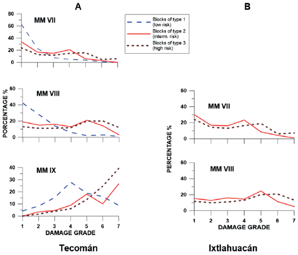
Figure 10 Damage curves corresponding to the DPM-block calculated for three types of residential blocks in Tecomán (A) and Ixtlahuacán (B).
Fig. 11A presents a microzonation of the seismic risk of residential blocks in Tecomán. The blocks with different types of housing do not have a defined distribution. Not numerous blocks of type 1 with relatively low level of seismic risk are located without any regularity. The blocks of type 2 with intermediate seismic risk are dominated here and distributed throughout the entire territory of the settlement. The blocks of type 3 with houses, built of adobe and built without a project, are numerous within this town also and represent the housing of the high seismic risk. They concentrated within the historic center of the city and within outskirts of the town.
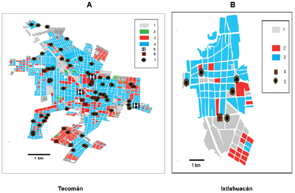
Figure 11 Microzonification of seismic risk for residential blocks of Tecomán (A) and Ixtlahuacán (B). The maps of microzonation of seismic risk represent the distributions of three types of residential blocks which reflected the level of seismic risk for the locality’s constructions. In these maps are shown also the positions of hospitals and medical centers, which are important in the case of destructive earthquake, as well as the positions of schools, representing the places of high seismic risk for children. In A: 1, commercial centers and federal zones; 2-4, residential blocks of type 1 (2), type 2 (3) and type 3 (4); 5, hospitals; 6, medical centers; 7, schools. In B: 1, commercial centers and federal zones; 2-3, residential blocks of type 2 (2) and type 3 (3); 4, medical centers; 5, schools. Residential blocks of type 1 represent zone of relatively low risk; residential blocks of type 2 represent zone of relatively intermediate risk; and residential blocks of type 3 represent zone of relatively high risk.
Probabilistic appraisal of possible losses in housing of Tecomán, destructed by earthquakes of different intensity, is demonstrated with DPM_cost, giving the percentage of the losses in cost of housing compared with the price of the house before the earthquake. The cost of losses for the residential blocks can be estimated with knowledge of the average cost of all three types of housing that constitutes the blocks. Table 7A shows the percentage of the losses for three types of residential blocks with different level of seismic risk. In the case of earthquake with intensity MM VIII, the losses, compared with the price of the housing before the earthquake, will reach 40% for the housing of high level of seismic risk, 27% for the housing of intermediate level of seismic risk, and 6% for the housing of low level of seismic risk.
Table 7 Damage probability matrix DPM_cost giving the losses in cost of housing (in %) during earthquakes with intensities MM VII, VIII and IX compared with the price of the housing before the earthquake for three types of residential blocks in Tecomán (A) and Ixtlahuacán (B)
| A | |||
|---|---|---|---|
| Intensity MM | Blocks of high seismic risk (type 3) | Blocks of intermediate seismic risk (type 2) | Blocks of low seismic risk (type 1) |
| VII | 21 | 10 | 4 |
| VIII | 40 | 27 | 6 |
| IX | 65 | 41 | 29 |
| B | |||
| Intensity MM | Blocks of high seismic risk (type 3) | Blocks of intermediate seismic risk (type 2) | |
| VII | 14 | 25 | |
| VIII | 29 | 42 | |
Microzonation of Seismic Risk for the Village of Ixtlahuacán
The village of Ixtlahuacán is the municipal center with population of 2,717 inhabitants; its area is equal to 6 km2 (INEGI, 2010). Ixtlahuacán is located within the Sierra Madre del Sur at the heighs of about 150-170 m. Ixtlahuacán is located at a distance of about 110 km from the Mexican subduction zone. According to Table 3, Ixtlahuacán can suffer destructive damage during earthquakes of Zone 1 (I max VII) and Zone 2 (I max VII).
The evaluation of the housing of Ixtlahuacán was carried out during 2014 for 85 residential blocks. The houses are mostly of poor quality. The blocks of type 1 are absent. The housing is represented by 18 (21%) blocks of type 2 and 67 blocks (79%) of type 3. The average distribution of three types of residential buildings within each type of blocks is presented in Table 5B.
To quantify the seismic risk for the housing of Ixtlahuacán, represented in these blocks, the probabilistic matrix of expected damages DPM_block for the housing was calculated for expected earthquakes with intensities VII to IX MM (Table 8). Intensity VII MM was expected as I max for earthquakes from Zone 2 and Zone 1. Intensity VIII MM was considered for the case of housing constructed above the low-quality soils.
Table 8 Damage probability matrix for three types of residential blocks in Ixtlahuacán (in %) for earthquakes with intensity MM VII and VIII.
| Damage grade | Blocks of type 1 | VII Blocks of type | Blocks of type 3 | Blocks of type 1 | VIII Blocks of type 2 | Blocks of type 3 |
|---|---|---|---|---|---|---|
| 1 | 0 | 30 | 24 | 0 | 15 | 12 |
| 2 | 0 | 17 | 14 | 0 | 13 | 10 |
| 3 | 0 | 16 | 13 | 0 | 16 | 11 |
| 4 | 0 | 23 | 16 | 0 | 15 | 13 |
| 5 | 0 | 9 | 19 | 0 | 25 | 20 |
| 6 | 0 | 4 | 6 | 0 | 11 | 21 |
| 7 | 0 | 1 | 7 | 0 | 5 | 13 |
Fig. 10B demonstrates the damage curves for two types of blocks, constructed on the base of Table 8, which illustrate the comparative damage effects. These curves indicate that in case of earthquake with intensity VII the damages of both grades 6 and 7 can be expected for 5% of residential blocks of type 2 in case of earthquake with intensity VII, and can reach 16% in case of earthquake with intensity VIII. For blocks of type 3, totally 13% of damages of both grades 6 and 7 in housing can be expected in case of earthquake with intensity VII and 34% in case of earthquake with intensity VIII.
Fig. 11B presents a microzonation of the seismic risk for residential blocks in Ixtlahuacán. As was noted above, the blocks of type 1 with relatively low level of seismic risk are absent. The blocks of type 3, representing the housing of the high seismic risk, are distributed practically throughout the total settlement. The blocks of type 2 with intermediate seismic risk are concentrated mainly within the southern part of the Ixtlahuacán, in the areas of modern urban development.
Probabilistic appraisal of possible losses in housing of Ixtlahuacán, destructed by earthquakes of different intensity, is demonstrated with DPM_cost. Table 7B shows the percentage of the losses for three types of residential blocks with different level of seismic risk. In the case of earthquake with intensity MM VIII, the losses, compared with the price of the housing before the earthquake, will reach 40% for the housing of high level of seismic risk, 27% for the housing of intermediate level of seismic risk, and 6% for the housing of low level of seismic risk.
Discussion
Two elements of the seismic risk, seismic hazard and seismic vulnerability of housing, refer respectively to natural and human activity. The level of seismic hazard, as the natural phenomenon, depends on the magnitude and position of the seismic sources relatively the site of study. Observations of large earthquakes, occurring in the region of study during more than 100 years, allowed us to consider the estimated parameters of the seismic hazard as regular enough.
The seismic vulnerability of housing describes the ability of houses to resist this earthquake action. This element of seismic risk is subjective and depends strongly on the human memory and understanding of destructive effects of previous earthquakes as well as on changing level of the quality of housing. Damage probability matrices, DPMs, are proposed to reflect this understanding and to give notion of possible actions to diminish the risk of loss of life and houses.
Effectivity of DPM, prepared by a group of specialists, may depend on some specific factors. Among them are the existence or not of proper experience of these specialists in sensations of destructive earthquake, and the time interval between destructive earthquakes in the locality. We discuss now the sensibility of proposed DPMs for Colima city on these specific factors.
The first DPM for three types of masonry in the central part of Colima city, described in Section of Evaluation of the seismic vulnerability of the localities with LRNE buildings and shown in Figure 9, was proposed in 1999 for earthquakes of intensity MM VI to IX for typical blocks of three zones of the city (Zobin and Ventura-Ramírez, 1999). The urban development in Colima has a concentric structure: the older Zone I, which was constructed before 1960, is situated in the central part of the city and is surrounded by Zone II, constructed from 1960 to 1980. The outer circle (Zone III) represents modern buildings. Most old buildings (before 1980) are of types C and B; more recent buildings are of types A and B. Description of the building of three types is given in Section. 2.2. The DPM-1999 version for earthquakes with intensity MM VII is shown in Figure 12 for three typical zones of the city.
This DPM was based practically on experience in destructive effects observed in Colima city during the Mw 7.6 earthquakes of 15 April 1941 and of 30 January 1973 (events Nos 3 and 4 in Table 2 and in Fig. 2). In 1941, the total Colima city was situated within Zone I and was occupied mainly with buildings of type C. According to information, presented by the Governor of State in September 1941, 75% of the total 5,115 residential houses of Colima city were destroyed (Bracamontes-Ceballos, 2018). In 1973, the city occupied zones I and II. According to Figueroa (1974), totally 200 residential houses were completely or partially destroyed in Zone I. This information was reflected in the curves of possible damage for housing calculated for three typical blocks based on DPM-1999. As is seen in Figure 12, the prognostic for Zone I predicted, in the case of intensity MM VII, heavy damage of index 5 for 40% of the total houses and major damage of index 6 for 10%.
The DPM-1999 was tested soon by the M w 7.5 2003 earthquake which was felt in Colima city with MM VII (Zobin et al., 2006; Zobin and Pizano-Silva, 2007). The 2003 earthquake (event No 8 in Table 2 and Fig. 2) occurred on 21 January near the coast of Colima state. Hypocenter of earthquake was situated within the El Gordo graben, which intersects the Mexican subduction zone and the Middle America trench (See Fig. 6B), locating at a depth of 10 km and at a distance of 65 km from Colima city. The macroseismic investigation of damages produced by the 21 January 2003 earthquake in Colima city, México, was realized for 3,332 constructions within the area of study representing about 20% of the city area and covered with the different type of constructions. The results of macroseismic study are shown in damage curves (Figure 12).
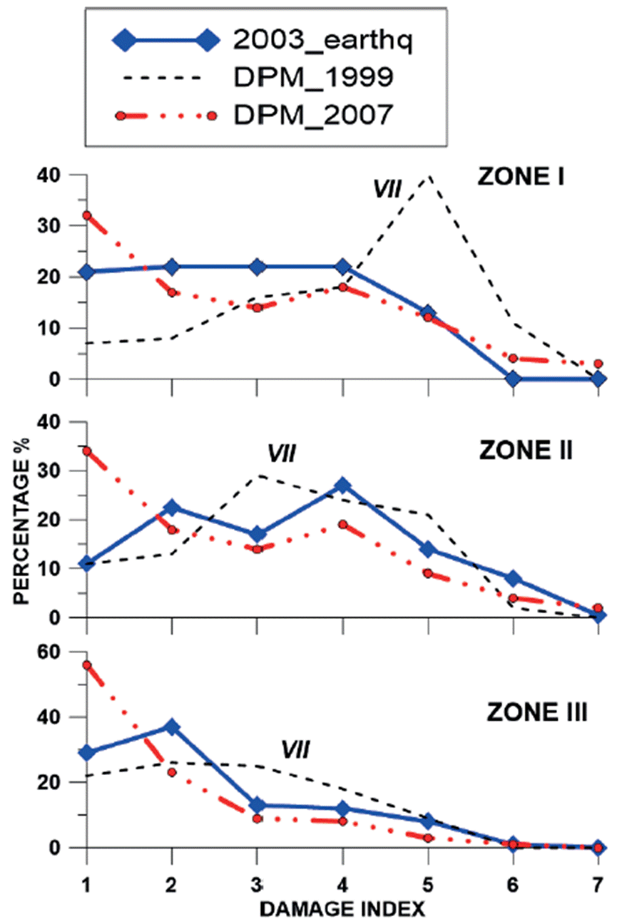
Figure 12 Comparison of observed damage matrix, obtained in Colima city for zones I, II, and III (heavy lines) after the 2003 earthquake, with the prognostic curves, calculated for typical blocks of three zones based on DPM-1999 and DPM-2007, proposed in (Zobin and Ventura-Ramírez, 1999) and (Zobin and Pizano-Silva, 2007) for earthquakes that could be felt in these zones with intensity MM VII (dashed lines).
As is seen, these results for zone I differ with proposed by the curve of DPM-1999. In 2003, Zone I was covered with a mixture of three types of masonry and the experience of 1941 and 1973 did not served. Now only about 15% of housing was characterized by heavy damage of index 5. More modern constructions of zones II and III were better familiar to the members of the 1999 expert group, and it gave a possibility to propose the curves DPM-1999 better corresponding to the 2003 observations of MM VII-grade effects in these two zones.
The DPM-2007 version (Table 4) was prepared by the specialists with experience of the 2003 earthquake (Zobin et al., 2007). Figure 12 shows the curves of possible damage, which were calculated for three zones of Colima city based on DPM-2007 for MM VII earthquake. These prognostic curves are in good correspondence to the observed damage matrix calculated by Zobin et al. (2007) for the effects of the 2003 earthquake and shown in this Figure. Well, we can wait for the next destructive earthquake to check their effectivity. As a practical lesson from these analyses of DPMs, we can propose to re-calculate DPM for every locality each 25-30 years.
The methodology presented in recent article may be applied for many similar in the LRNE housing cities of Asia, Africa, and Latin America. The preliminary reconnaissance carried out in some lowrise cities of the Pacific coast areas of México, Colombia and Perú showed that the buildings of these cities are similar to three types of Colima buildings (Zobin, 2008). This allows the application of this non-instrumental, inexpensive but efficient methodology for the microzonation of seismic risk in the LRNE housing cities situated in similar zones.
Conclusions
This article proposes a simplified methodology of the seismic risk evaluation for the localities, where the vulnerable low-rise, non-engineered (LRNE) housing represents the majority of residential constructions. The methodology is based on evaluation of two main sources of information: the internet-available catalogs of world-wide of recent and historical earthquakes and visual inspection and classification of the vulnerability level of residential LRNE houses, and visual macroseismic inspection of the residential house damage after destructive earthquakes. This methodology was applied to the localities of the State of Colima, México, characterizing with the LRNE type of residential houses. The microzoning of the seismic risk for two localities of the State is presented together with a probabilistic prognostic of the expected financial losses during the maximum intensity earthquakes at the localities. The damage probability matrix DPM-2007, proposed for Colima city, may be used for urban planning for other towns of Colima state as well as of for the cities of other Mexican states situated along the Pacific coast and having similar masonry.

