


 text new page (beta)
 English (pdf)
 Article in xml format
 Article references
 Send this article by e-mail
 Cited by SciELO
  Similars in
SciELO
Similars in
SciELO 
 Permalink
Introduction
The northern Iranian loess record is in excellent agreement with the loess record of the Northern Hemisphere, e.g., Europe (Frechen et al., 2003), Central Asia (Frechen and Dodonov 1998; Machalett et al., 2006), or southern Middle Siberia (Frechen et al., 2005). During the 1960s and the 1970s, loess and the intercalated palaeosols were correlated with moist and dry periods of the Holocene (Barbier, 1960; Ehlers, 1971; Frechen, et al., 2009). Generally, little information is available about the climate change in the dry regions of central and northeast Iran, although an argument commonly accepted is that loess accumulated during cold and dry glacial periods and the results of numerous investigations on loess deposits have led to a common acceptance of the close relationship between loess accumulation and soil formation with dry-cold and moist-warm periods, respectively (Karimi, et al. , 2009). Similarly, the initial hypothesis of our studies is probably over the past 50ka, loess particles of Kolet Section transported by wind during glacial periods, and then paleosol horizons formed during interglacial periods. First of all we applied some magnetics methods to confirm our deposits bear enough magnetical particles, and it is a good idea to using environmental magnetic proxies such as variation of magnetic susceptibility (MS) to detect glacial/interglacial cycles versus lithological profile.
There is some investigation such as Kehl et al. (2005) that inform us the loess record from north of Iran is an excellent archive of climate and environmental changes at least for the past 800ka as demonstrated by up to eight intercalated pedocomplexes in the Neka area. On the other hand there is not any investigation or working on paleomagnetism of Neka loesses. There was some doubt about magnetic capacity of Neka loess for environmental magnetism studies, specially using magnetic susceptibility (χ) curve to detect paleoclimatically changes (glacial/interglacial cycles). In fact, the loess record of Northern Iran perhaps provides a missing link for the correlation between Central Asian and European loess archives, as well as Frechen, et al., 2009 mentioned the Caspian Lowland of Northern Iran is part of the Eurasian loess belt extending from Northwest Europe to Central Asia and China.
This study aims to confirm reconstruction of climatically changes by using magnetic methods and comparing the curves of magnetic parameters together. As have been explained before, little information has been published on records of past climate change in Northern Iran. Moreover, in order to improve the environmental magnetism studies of Iran and reconstruct paleoclimate changes, loess records of northern Iran especially in this area require more information from other field investigations. Actually there is no magnetically investigation on Neka loess has done before; also no investigation of magnetical capacities of loess/paleosol sequences of Iran has been studied. However this study detect the models of paleoclimate changes, by using an environmental magnetism proxy, variation of magnetic susceptibility (χ) curve for Neka loess/paleosol sequence, but it is necessary to assemble more investigation results for this area in the future works.
Study area
The study area is located in the Caspian Lowland of Northern Iran, on the northern foothills of the Alborz Mountains east of Sari (Fig. 1), which is a little piece of loess deposits in the east of north-central of Iran. This zone consists of areas that are located in the north of the Alborz fault, bounded to the north by the Caspian Sea, and the northern coastal plain of Iran, which are covered with thick layers of loess, to the east. Loess profile is found in a mine, on the northern foothills of the Alborz Mountains near the main road of Sari-Behshahr, Mazandaran providence (Fig. 1). The oldest deposits of area are Jurassic limestones and dolomites covered by wind-blown loesses with a significant expansion (Kabirnia et al., 2003), in most parts of study area. Northern of Iran is mentioned by Tietze (1877), Stahl (1923) and Bobek (1937) as little information loess deposits about the nature, origin and chronology of the loess has ever been published. Kehl et al. , (2006) studied some part of this area and found several well-developed palaeosol horizons intercalated in the loess record indicate an alternation of comparatively dry and cold climate phases with increased dust accumulation including loess formation, and moist and warm phases with soil formation, respectively. Furthermore, this area was described by Frechen, et al. (2009), who suggested that the loess/palaeosol sequences of the Caspian Low land in Northern Iran provide detailed archives of climate and environmental change showing a close relationship to global cooling and warming trends for the late Pleistocene and Holocene period.
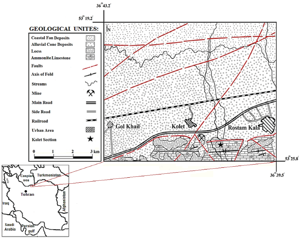
Figure 1 The Geological Map of the study area illustrates Geological structures and lithology of costal and mountainous region (Haskouei and Alimohammadian, 2020).
The study section which is informally named as Kolet Section falls between 36° 39' 44" N and 53° 23' 56" E. It is situated at about 8 km away of Neka city, almost opposite of Kolet Village, near the main road of Sari-Behshahr, in Mazandaran Province, north of Iran. It is bounded by Alborz fault in the south and Caspian Sea coast line in the north (Fig. 1). Based on field observations, Loess/paleosol sequence followed the paleogeomorphology patterns and deposited on altitudes and lowlands of the older rocks (Fig. 2), which are probably late Jurassic marl limestones, or perhaps the same Ammonite limestone shown in the geological map of the study area (Fig. 1).
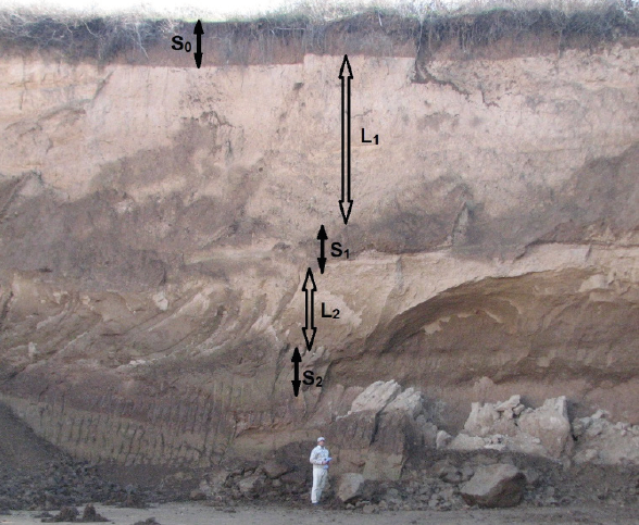
Figure 2 the loess/palaeosol sequence of Kolet section, at Neka, Mazandaran Province, northern of Iran. Black color arrows show two loess sub-divisions (L1 and L2). Upper Palaeosol (S1) is limited between two red lines; and Lower Palaeosol (S2) is under white line; and Recently Soil sub-division (S0) is marked on top, with yellow line (Haskouei and Alimohammadian, 2020).
OSL dates for studied section are obtained by Kehl, et al., (2005), and described loess/palaeosol sequences a maximum thickness of approximately 20m covers Jurassic limestone of the Alborz front hills. The lithological units are described as the following: 0-2 m is composed of Recent Soil horizon (S0). OSL age of the bottom of S0 is 20.5±2.0ka; 2-8.3 m is Upper Loess with a buffed-yellow color (L1). OSL age of the bottom of L1 is 37.8±3.6ka; 8.3-8.7m is Upper paleosol, a developed narrow paleosol (S1) with a red brown color. From top to bottom of S1, the color becomes light, and pedogenesis become weaker. Second loess deposit is Lower Loess (L2) with buffed-yellow color at the depths from 8.7 to 9.9m; 9.9-10.7m is composed of dark brown paleosol (S2). OSL age of S2 is 48.7±4.7ka (Fig. 2).
Sampling and Methodes
The total number of 117 samples with 10 cm intervals (in thinner layers 5 cm intervals) were collected from loess (paleosol) units (Fig. 3-a to d). Magnetic susceptibility (MS), magnetic mineralogy, Isothermal remnant magnetization (IRM), Saturation Induced Remnant Magnetization (SIRM) carried out on samples. Natural Remnant Magnetization (NRM) was measured, using Spinner (JR-6A). Isothermal Remnant Magnetization (IRM) acquisition experiments were carried out using a Pulse Magnetizer, a T electromagnet and a spinner magneto-meter. Isothermal Remnant Magnetization (IRM) curves acquired in 13 incremental steps up to a maximum field of 800mT, using Pulse Magnetizer (MMPM10). Hence, the intensity of the magnetic field gradually was increased, from 10 mT to 2 T, on 13 steps; and NRM of samples were measured each time, again and again, to calculate Saturation Induced Remnant Magnetization (SIRM). Also, to reveal the presence and kind of magnetic minerals, the AF demagnetization experiments have been applied by using an Alternative Field Demagnetizer, and instantly, the variation of remnant magnetism of samples have been measured again, using a spinner magnetometer. Furthermore, magnetically parameters like S-ratio, HIRM, and S-0.3T were estimated (Tab. 1) to quantify the relative and absolute concentrations of antiferromagnetic minerals (e.g., hematite and goethite). It should be noted that, in addition to AF demagnetization experiment, thermomagnetic analysis have been applied aside from the magnetic mineralogy experiment, to confirm the presence and kind of magnetic minerals, using Multi-Function Kappabridge and a thermal furnace is referred to as CS-3.
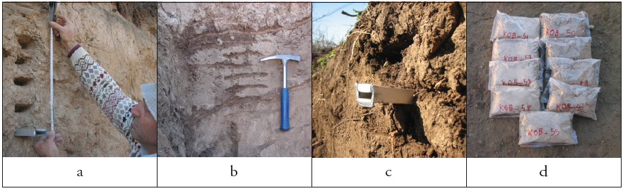
Figure 3 sampling of loess/paleosol to exactly 117 packs. (a) 10 cm intervals for loess units; (b) 5 cm intervals for paleosol; (c) a good view of Recent Soil and 5 cm intervals for packing ; (d) some pack samples of loess deposits during field working and packing.
Table 1 Magnetic analysis and measurement such as Magnetic Susceptibility (M.S.), Induced Remnant Magnetization (IRM), SIRM, S-ratio and etc. (LR and UR refer to Lower Red palaeosol and Upper Red palaeosol sub-divisions, respectively). Please refer to text for further description.
| Samples No. |
Depth (cm) |
S-ratio | χ (10-5m3kg-1) |
SIRM | S-0.3T | IRM-0.3T | HIRM |
|---|---|---|---|---|---|---|---|
| KO01 | 10 | 0.838721 | 67 | 5.506 | 0.080639 | 4.618 | 3.172 |
| KO10 | 100 | 0.866991 | 117 | 8.225 | 0.066505 | 7.131 | 4.55 |
| KO20 | 200 | 0.878472 | 100 | 7.776 | 0.060764 | 6.831 | 4.33 |
| KOB10 | 310 | 0.850567 | 48 | 4.41 | 0.074717 | 3.751 | 2.63 |
| KOB20 | 410 | 0.836097 | 41 | 4.161 | 0.081951 | 3.479 | 2.5 |
| KOB30 | 510 | 0.837142 | 37 | 4.157 | 0.081429 | 3.48 | 2.5 |
| KOB40 | 610 | 0.840844 | 41 | 4.216 | 0.079578 | 3.545 | 2.53 |
| KOB50 | 710 | 0.851059 | 29 | 4.109 | 0.074471 | 3.497 | 2.5 |
| KOB60 | 810 | 0.835368 | 74 | 6.961 | 0.082316 | 5.815 | 3.9 |
| KOB66UR | 850 | 0.842847 | 85 | 7.165 | 0.078576 | 6.039 | 4 |
| KOB70 | 870 | 0.821962 | 73 | 5.628 | 0.089019 | 4.626 | 3.225 |
| KOB80 | 970 | 0.795291 | 50 | 4.162 | 0.102355 | 3.31 | 2.5 |
| KOB83LR | 995 | 0.841182 | 103 | 6.498 | 0.079409 | 5.466 | 3.669 |
| KOB90LR | 1030 | 0.851347 | 96 | 6.902 | 0.074326 | 5.876 | 3.876 |
| KOB97 | 1070 | 0.754974 | 21 | 2.865 | 0.122513 | 2.163 | 1.81 |
Also, Magnetic susceptibility of bulk samples, (χ), was measured as main parameter to reconstruct paleoclimate changes, using Multi-Function Kappabridge (MFK1-A). It measured for 117 individual samples were collected from about 10 m profile of Loess/palaeosol sequence (Fig. 4).
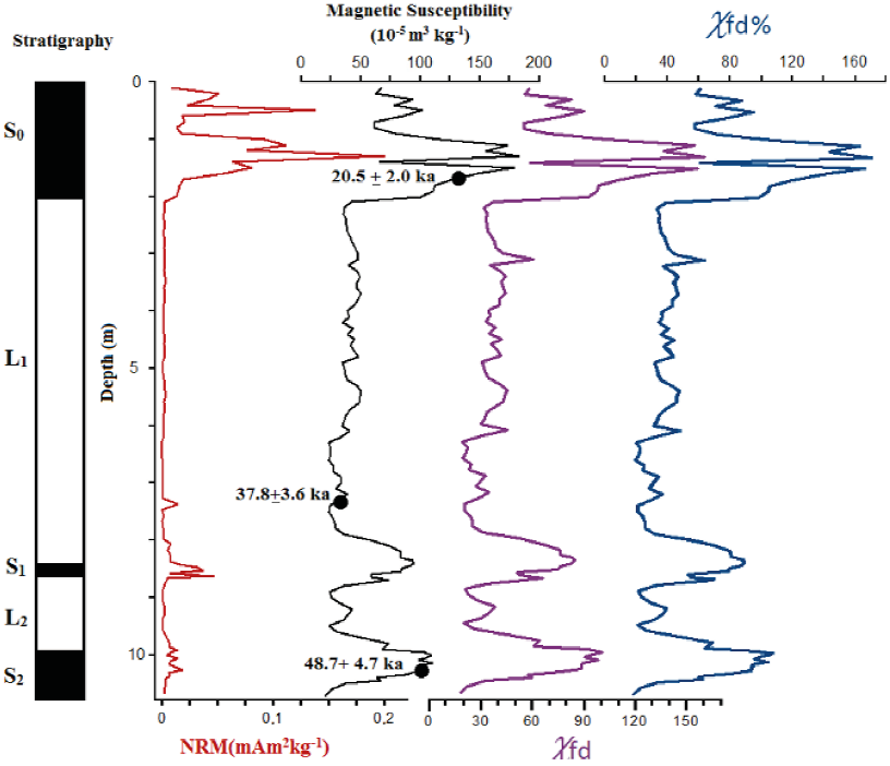
Figure 4 Lithology, Natural Remnant Magnetization (NRM), and Magnetic Susceptibility (χ), Frequency Dependent Susceptibility (χfd) and χfd% of the loess profile from Kolet Section, at Neka, north-east of Iran. χfd is sensitive to the absolute concentration of superparamagnetic particles; and χ is contributed from both aeolian and pedogenic particles; and χfd% is sensitive to the grain size distribution of superparamagnetic particles. OSL dates (solid circles) for loess/ paleosol sequence are from Kehl, et al., (2005). Please refer to text for further description.
Totally, to confirm magnetical capacities of Neka loess magnetical proxies were investigated, such as:
1) Curved Magnetic Susceptibility (χ) to reveal cool/arid (=glacial/perglacial) and humid/warmer (=interglacial) cycles.
2) Identity and demonization of size of magnetic minerals by plotting SIRM curve.
3) Assessment of magnetic mineralogy in loess and paleosols by estimation of saturation ratio (S-ratio).
4) Investigating of the presence of magnetical particles like magnetite, maghemite and other iron-bearing minerals, to identification of magnetical capacities of loess/paleosol sequences.
5) Plotting HIRM and cure to showing the presence of high and low coercivity minerals.
6) Plotting χfd% and χfd parameters to reveal presence of viscous magnetical component and grains.
Results
1) The χ values show prominent peaks for the three well developed soil and paleosol horizons, (S0), (S1) and (S2); In contrast, the x curve for Upper Loess (L1) is relatively smoothed. The second Loess horizon (L2), in the 860-990 cm interval, corresponds to a moderate magnetic susceptibility peak (Fig, 4).
2) As figure 4, magnetic enhancement (pedogenic ferrite formation) is evident from increased values of χ and χfd%; and Frequency Dependent Susceptibility (χfd) [percentage or m3kg-1] is variation in χ between low (0.47 kHz) and high frequencies (4.7 kHz).
3) There is determined for 15 representative samples spread throughout the profile (Tab. 1). All samples reach their ultimate maximum values in a field of 300 mT. The backfield necessary to reduce the saturation IRM (SIRM) to zero) fall in the range -30 to -60 mT for most of samples, while the SIRMs themselves range from 2.8 to 8.2 mA m2 kg-1 (Tab. 1).
4) To confirm the presence offerromagnetic minerals, IRM acquisition experiments were carried out (Fig. 5 and 6). Samples containing ferromagnetic minerals (magnetite) are completely saturated when the magnetic field reaches to less than 2 Tesla (2000 ml); as can be seen on Fig. 5, samples contain ferromagnets particles show steep increases in magnetization with applied field, until reaching saturation magnetization (SIRM).
5) According to figure 6, the discontinuity of the magnetic field line, in the range of -30 to -60 mT, where the magnetic field line is near to reach to zero, indicates the presence of magnetic minerals like magnetite and maghemite. Also, the acquisition (forward direction) and demagnetization (backfield) curves are all similar and are dominated by low-coercivity minerals. All samples reach at least 90 percent of their ultimate maximum values in a field of 300 mT.
6) In figure 7, red diagram is HIRM with sharp increases in three maximum points of the cure for the three well developed soil and paleosol horizons, (S0), (S1) and (S2)
7) Variations of the SIRM showed that the concentration of total ferrimagnetic (ferromagnetic) a material in the paleosols is enhanced (Fig. 7, green colored diagram).
8) The results of thermomagnetic analysis reveal the presence of magnetite as a ferromagnetic (ferrimagnetic) mineral. It is expectable that the ferromagnetic minerals in the magnetic field saturate with less than 1 Tesla for Kolet samples by figuring black colored diagram in figure 7.
9) Total decreasing S-0.3T (from 0.06 to 0.12 A/m) versus total increasing HIRM (from 2 to 5 A/m), shows the amount of low coercivity minerals (including magnetite and maghemite) in the paleosols is much less than high coercivity minerals; and to the contrary, the amount of low coercivity minerals in loess horizons, is much more than high coercivity minerals (Fig. 7).
10) All data and results of magnetism methods, above all variation of Magnetic susceptibility (MS) curve confirm loess-paleosol sequences of Kolet section as suitable sediments with enough magnetic particles capacity (Fig.8).
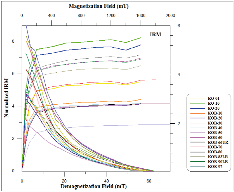
Figure 5 Variations of the Isothermal Remnant magnetization (IRM) versus demagnetization field, for 15 samples in Tab. 1; the rising lines on the left of the graph, starting from zero, curved near 300mT which represent the magnetic saturation of the samples; completely saturation of Kolet samples, acquired at about 1600 mT; and the downward-curved lines to the right of the graph, which are zero at about 60 degree, indicating the AF demagnetization of samples.
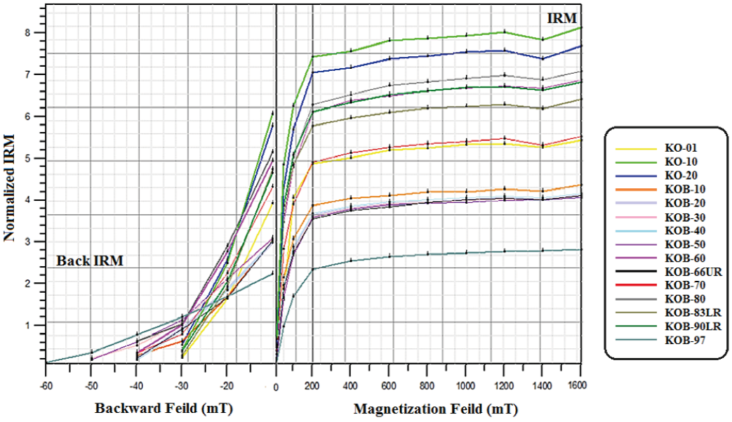
Figure 6 Variations of the Isothermal Remnant magnetization (IRM) versus backward field, for 15 samples in Tab. 1; the rising lines on the right of the graph, starting from zero, curved near 300 mT which represent the magnetic saturation of the samples; and the downward-curved lines to the left of the graph, which are zero in the range of -30 to -60 mT, indicating the back IRM.
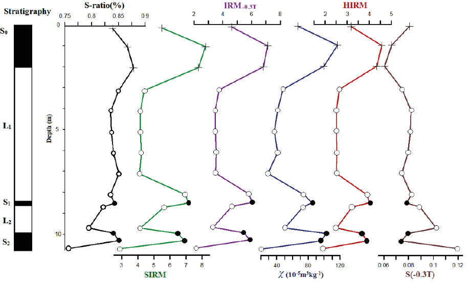
Figure 7 Variations of the IRM saturation ratio (S ratio %), and SIRM (IRM at 2T), Magnetic Susceptibility (χ), and IRM0.3T, and HIRM and the mineral-magnetic parameter S-0.3T, for 15 selected samples (Tab. 1), in the Kolet Loess-Paleosol sequence. Open circles: loess data, closed circles: paleosol data, crossed-out symbols: Recent Soil data. The IRM-0.3T denotes 0.3T back-field IRM values. Please refer to text for further description.

Discussion
Many environmental scientists are familiar with the use of one magnetic parameter, magnetic susceptibility, measurements of magnetic susceptibility are normally just the first, and most basic, step in characterising the magnetic properties of any sample (Maher, 2011). The very comprehensive and detailed study of Liu et al., (1985) verified that highs and lows of the susceptibility curves are closely correlated with the occurrence of paleosols and loess layers, respectively (Heller and Liu, 1984; Heller et al., 1991). Briefly, Less-weathered loess sequences, therefore, represent an arid and probably cool (=glacial/perglacial) climate during their accumulation, while the paleosols correspond to a more humid and warmer (=interglacial) climate (Akram, et al., 1998).
Maher (1998) mentioned that Magnetite and maghemite are responsible for most of the signal because their susceptibility is three orders of magnitude greater than that of other iron-bearing minerals such as goethite, hematite, lepidocrocite and ferrihydrite.
IRM and back-field IRM values yield useful parameters for estimating the enrichment of low coercivity or high coercivity minerals in the samples. To make a simple statement, the IRM and back-IRM acquisition experiments acquired under the 2.5T revealed the presence of magnetite/ maghemite along with some high coercive mineral, maybe goethite. Also, saturation isothermal Remnant magnetization (SIRM) crossover plots are a simple way of determining the identity and domain size of magnetic minerals, through the use of SIRM acquisition and demagnetization curves and the position of the crossover point of the curves. Also, SIRM is a concentration-dependent parameter, i.e. it is high if the amount of ferromagnetic material present is high and vice versa (Szabo and Cioppa, 2004; Akram et al., 1998).
Jin and Liu (2011) mentioned, whenever the IRM acquisition curves with similar shapes for all samples; and it climbs rapidly below 200 mT and reaches approximate saturation at about 300 mT; this behavior reveals the existence of soft magnetic minerals, such as magnetite and/or maghemite. They suggested that for loess samples, the IRM curves show slight increases from 300 mT up to 2 T, indicating presence of hard magnetic components, such as hematite and/or goethite.
In the other words, the sudden rise below 300 mT in all of the IRM acquisition curves indicates the presence of low coercivity minerals, like magnetite and/or maghemite. The unsaturated component (>300 mT) is carried by a high coercivity mineral, possibly goethite (Akram, et al:, 1998).
The saturation ratio (S-ratio) is a parameter to assess magnetic mineralogy in loess and paleosols; and where "S" is the absolute value of the IRM remaining after exposure to a reversed field of 0.3 T divided by the saturation IRM (or SIRM), which is usually acquired in a field of 1-2T. This parameter is calculated from IRM-0.3T/SIRM and represents the properties of magnetic minerals; and it is also serves as a measure of the proportion of high coercivity minerals (i.e., hematite and goethite) to low coercivity minerals (i.e., magnetite and maghemite) in a material (King and Channell, 1991; Roberts et al., 1995; Verosub and Roberts, 1995). For most samples, the "S" values are close to 1, suggesting low-coercivity and ferri-magnetic mineralogy (Deng et al., 2004; Akram et al., 1998).
Next parameter is HIRM, a measure of the concentration of high coercivity minerals which its values become large if high coercivity minerals are relatively abundant. Another parameter, S-0.3T is a contrasting measurement to indicate the relative abundance of low coercivity mineral (Bloemendal et al., 1992; Akram et al., 1998). Sharp increases in magnetic susceptibility and in HIRM indicate enhanced aeolian influx of ferrimagnets and of haematite/goethite, respectively (Maher, 2011).
Also, it is well accepted that whenever χfd%, measured between ~10% or 5-10%, it would indicate a large fine viscous (magnetite) component of SP range; and χfd indicates viscous grains at the superparamagnetic/stable single-domain boundary; and χfd% is a sensitive parameter for detecting the presence of SP grains in soils (Maher, 1988, 2011). In the other words, χfd is sensitive to the absolute concentration of SP particles; χ is contributed from both aeolian and pedogenic particles; and χfd% is sensitive to the grain size distribution of SP particles. Hence, Very special adjustment of the grain size distribution is needed to keep both the linear relationship between χfd and χ and the constant χfd% (Liu et al. , 2004c).
Conclusion
(1) χ and χfd and χfd% show a perfect linear correlation and a high degree of similarity, in their variations and as we mentioned before, the χ values show prominent peaks for the three well developed soil and paleosol horizons, Recent Soil (S0), Upper Paleosol (S1) and Lower Paleosol (S2); which refer to the presence and concentration of single domains magnetic minerals such as magnetite and maghemite.
(2) The results of Environmental magnetism techniques confirmed increasing/decreasing of magnetic susceptibility plot, as instance the results of the magnetic mineralogy experiment indicated the presence of ferromagnetic such as magnetite in the samples, which is the main factor of magnetic property in loess/paleosol sequence. Also, IRM and SIRM diagrams, and variations of magnetically parameters like HIRM and S-0.3T indicated the presence of low coercivity minerals such as magnetite in loess accumulations more than high coercivity minerals. The presence of high coercivity minerals like hematite, indicate weathered conditions for paleosols horizons. On the other hand, the results of both Back-field and Frequency Dependent Susceptibility (χfd) diagrams indicated the presence of single domains magnetic minerals like magnetite.
(3) The obtained magnetic data indicate that over the past 50 ka, there have been at least two glacial/interglacial periods in the study area and since last 20 ka, there was no glaciations in the study area to produce loess deposits. The χ values show prominent peaks for the three well developed soil and paleosol horizons, Recent Soil (S0), Upper Paleosol (S1) and Lower Paleosol (S2); which probably refer to warmer and wetter conditions of interglacial periods.
(4) Increasing/decreasing of magnetic susceptibility probably is coinciding with palaeosol/loess and interglacial/glacial cycles, respectively, which means probably Loess was transported and deposited during cooler, drier periods; after then paleosols formed when the climate became warmer and wetter in northern Iran.

