


 text new page (beta)
 English (pdf)
 Article in xml format
 Article references
 Send this article by e-mail
 Cited by SciELO
  Similars in
SciELO
Similars in
SciELO 
 Permalink
Introduction
Recent advancements in geophysical data acquisition technology, improved flight specifications and acquisition of data very close to the ground surface (< 80 m - 150 m) have greatly improved the capacity of aeromagnetic survey to generate High Resolution Airborne Magnetic (HRAM) data which provide detailed geological information required for mapping subsurface geological structures (Reeves, 2005). HRAM data have also proved very successful in mapping topographical features of the subsurface basement surface which could influence the structure of overlying sediments. Large-scale aeromagnetic survey has gained relevance in locating regional faults and shear zones having huge potential as hosts for varieties of economic minerals, especially the epigenetic and stress-related mineralization (Paterson & Reeves, 1985). The method through determination of depth to basement rocks has also proved very useful in estimating the thickness of sedimentary pile above crystalline basement rocks (Reid et al., 1990; Nabighian & Hansen, 2005).
In this research, high-resolution airborne magnetic data acquired for the Nigerian Geological Survey Agency (NGSA) by Fugro Geophysical Limited in 2007 were analyzed, enhanced and interpreted to delineate structural framework and investigate the nature of the subsurface basement topography, in addition to expressing the geology and causes of the magnetic anomalies observed in the Abigi - Ijebu waterside area in southwestern Nigeria. The study area is situated in Abigi -Ijebu waterside in southwestern Nigeria, it is located on the flank of the eastern part of the Dahomey Basin, it is bordered in the south by the Atlantic Ocean and lies between longitude 4°00'E and 4°301 E; and latitude 6°201 N and 7°001 N (Figure 1).

Abigi in Ijebu waterside was in the past explored for its hydrocarbon potential mainly because of its proximity to Escravos in western Niger Delta, southern Nigeria and also for the occurrence of huge deposit of tar sands (bitumen), the deposit has been reported as the second largest deposit in the world, after that of Alberta in Canada. This study therefore seeks to investigate the subsurface of Abigi-Ijebu waterside and environs through the analyses of aeromagnetic data of the area with the object of providing information that could generate requisite information likely to further aid the exploration campaign of that section of the Dahomey Basin, especially with the success stories of oil discovery in Aje and Ogo fields offshore and western end of the Nigerian sector of the Dahomey Basin in southwestern Nigeria.
Geology of the Study Area
The Dahomey Basin forms one of the series of West African Atlantic marginal basin that were initiated during the period of rifting in the late Jurassic to early Cretaceous (Omatsola & Adegoke, 1981). During the rifting stage, there was basement fracturing and initial separation between the African and South American plates (Brownfield & Charpentier 2006). Several marginal basins were developed at this time resulting to block faulting, fragmentation and subsidence on the central Paleozoic basement rock (Omatsola & Adegoke, 1981).
The basin stretches along the coast of Nigeria, Benin Republic, Togo and Ghana along the margin of the Gulf of Guinea. It is separated from the Niger Delta by a subsurface basement high referred to as the Okitipupa Ridge. Figure 1 presents the geology of the study area while the insert is the geologic map of the Nigerian sector of the Dahomey Basin with adjacent crystalline basement rocks. The geology of the study area depict that of a transition zone between the Basement Complex rocks of southwestern Nigeria in the north and the sedimentary units that unconformably overly the depressed part of the crystalline rocks at the edge of the Dahomey Basin, around Abigi-Ijebu waterside area of the southwestern Nigeria. The Basement Complex rocks has been reported by various authors to comprise largely of a metasedimentary series with associated minor metaigneous rocks, which have been variably altered to migmatitic gneisses, and the Older Granites suite of both intrusive and replacement origin (Jones & Hockey, 1964: Grant, 1971; Burke et al., 1976). The northern part of the study area is dominated by crystalline rocks such as biotite granite gneisses and granodiorite, migmatite gneiss, quartz-feldspartic granulites, undifferentiated schist, quartz-schist and quartzites (Figure 1) (Burke et al., 1976).
In the southern part of the study area, sedimentary rock units defined through a stratigraphic setting of the eastern Dahomey Basin, as put together by several authors, such as Adegoke (1969), Ogbe (1970), Kogbe (1974), Billman (1976), Omatsola & Adegoke (1981), Ako et al., (1980), Okosun (1990) and Idowu et al., (1993), presented five (5) lithostratigraphic formations from the Cretaceous to Tertiary ages (Figure 1). The succession from the oldest to the youngest includes Abeokuta Group, Cretaceous in age and consists of Ise, Afowo and Araromi Formations as members. The Abeokuta group is immediately overlain in quick succession by Paleocene Ewekoro Formation, Eocene Ilaro Formation, Coastal Plain Sands and the Recent Alluvium in that order of succession. Table 1 presents the stratigraphic column of eastern Dahomey Basin as compiled by Obaje (2009).

Abigi-Ijebu waterside is situated at the edge of the Dahomey Basin where the basin gradually grades into the Basement Complex roeks of the southwestern Nigeria. Here, basement roeks are exposed in the north with no sediment cover. The central and towards the south of the study area, sediment thiekness gradually build up and grades from the very shallow part of the basin into the progressively deeper part of the basin. The thiekness of the sedimentary pile as recorded by Adegoke (1969) was put at just few tens of meters to somewhere just above 1000 m.
Materials and Methods
This section briefly describe how the aeromagnetie data of Abigi-Ijebu waterside area of southwestern Nigeria, used for this study, were acquired, as well as presents some of the various processing techniques employed to filter out unwanted signals, transform magnetic anomalies and enhance salient desirable subsurface magnetic attributes that helped to generate geological information used to image and understand the terrain.
Data Acquisition
Airborne magnetic data acquisition was done using a 3 x Scintrex CS3 Cesium Vapour magnetometer having sensitivity of 0.0006 nT √VHz rms, gradient tolerance of 40000 nT/ meter and absolute accuracy of less than 2.5 nT throughout the range. The magnetometer which was attached to the tail stinger (behind the empennage of the aircraft) of Cessna Caravan 208B ZS-FSA specialized aircraft uses FASDAS data acquisition system and took magnetic readings at 0.1 seconds recording interval, which is approximately 7 m interval. The aircraft flies at a sensor mean terrain clearance of 80 m, flight line spacing of 500 m, tie line spacing of 5000 m and flight and tie lines trends of 135o and 45o respectively. The flight was flown to run perpendicular to the general geological strike of the field (NGSA 2004; Reeves, 2005).
Data processing involves the transformation of acquired data from the original raw form to a state that bears simple and direct relationship with the terrain/subsurface geology and thus easier to interpret. The processing steps described in this paper exclude the preprocessing operations such as tie-line and micro-leveling, deculturing and others employed to remove residual flight line artifacts and filtering of cultural effects respectively, by the data acquisition company.
The preprocessed/partially processed aeromagnetic data obtained from NGSA were gridded with a cell size of between 1/3 to 1/5 of the flight line spacing, using minimum curvature gridding algorithm (Webring, 1981). The gridded data were thereafter subjected to several filtering operations, example includes Guassian low cut filter to remove the regional trend from the acquired Total Magnetic Intensity (TMI) and thus generate residual magnetic signal while Butterwort, low and high cut as well as band pass filters helped removed noise and noisy data such as cultural and background noise. Data enhancements techniques were applied to improve data quality and amplify specific components of the measured data, especially such components that would ease interpretation. Attribute extraction and derivative determination were performed to further aid interpretation. Horizontal or vertical derivatives, tilt derivatives and total horizontal derivative of the tilt derivative for example are good tools for lineament extraction and thus aid structural interpretation (Verduzco et al., 2004). Upward continuation filter was applied to minimize short wavelength signals corresponding to shallow sources and thus enhance deeper source effects. The filter also acts as a cleaning filter because of its ability to remove shallow magnetic signatures that emanate from cultural features and thus enhance relatively deeper anomalies.
Reduction to Pole at Low Latitude (RTPLL)
The shape of magnetic anomaly over a causative body is determined among other factors by shape, size of the causative body, depth of occurrence, magnetic inclination and declination of the inducing field at the survey location (Baranov & Naudy, 1964; Salem et al., 2007). The magnetic inclination and declination is dictated by geographical location and thus latitude has effect on the magnetic anomalies. Magnetic anomaly over a body at the poles, north or south, where magnetic inclination is 90o (I = 90o) or 0o at the equator (I = 0o) is believed to be simple to interpret and most importantly the anomaly peak is located directly over the causative body (Silva, 1986; Arkani-Hamed, 1988; Lu et al., 2003). At the mid north and mid south latitudes however, the anomaly becomes complex with the anomaly peak not lying directly over the corresponding source. Therefore to simplify anomalies and ensure that anomalies lie directly above the causative body, reduction to pole correction is usually applied.
Ijebu waterside in southwest Nigeria is located at mid north, slightly above the equator. It is also located at low latitude (around latitude 70), therefore anomalies in this study area are presented in complex form. Also the peaks of the anomalies may not be properly placed on top of the causative sources. This therefore demands the need to carry out reduction to pole correction to simplify the anomaly and for correct focusing of anomaly peak over the causative source. Reduction to the pole for data acquired at low magnetic latitudes (equatorial latitudes) is known to blow-up anomalies originating from north-south lying geological features (Li, 2008). The blow-up is associated with strong amplitude correction that is applied when the declination and wavenumber direction is ð/2 (That is, a magnetic East-West wavenumber) (MacLeod et al., 1993; Li, 2008). Thus a specialized correction known as reduction to pole at low latitude was usually applied. Reduction to the Equator (RTE) could also be applied, but this will invert the magnetic data making the anomalies appear negatively symmetrical over corresponding geologic sources. Reduction to the pole at low latitude (RTPLL) incorporates a separate amplitude correction which prevents signals from north-south geological features from becoming over blown and thus dominating the results (Keating & Zerbo, 1996). The specialized correction will simplify anomalies and focus the anomalies peak over the corresponding causative bodies which are easier to interpret without losing any geological/geophysical relevance.
Derivative and Tilt Angle Derivative filters
Derivative-based filters were used to sharpen the edges of magnetic anomalies and to determine their locations (Mushayandebvu et al., 2001). They were also used to enhance or suppress features in a given direction, such as x-, y-, and z- directions (Cooper & Cowan, 2008). The horizontal derivatives, along the x- and y-directions were calculated in order to estimate the magnetic variation along the horizontal. The vertical derivative along the z-direction on the other hand estimates vertical variation in magnetic properties of the rocks (Ekinci et al., 2013). Tilt derivative filter and the horizontal derivative of the tilt derivative grids were also generated to further enhance structural signatures of the magnetic data across study area. The tilt derivative filter, an analytic signal amplitude normalized ratio of vertical derivative to a value of total horizontal derivative (equations 1 & 2) is apt at enhancing the edges of features and other directional information inherent in potential data which oftentimes are of great structural significance (Miller & Singh, 1994; Verduzco et al., 2004; Ferreira et al., 2011).
TLT is the Tilt derivative filter,
Euler Deconvolution
The 3D Euler deconvolution is a depth estimating technique and it is used to determine depth and location of geologic unit or structure that produces magnetic anomaly. It uses the x-, y-, z- derivatives to determine location and depth for various idealized targets such as contact, dyke/sill, cylinder and sphere (Reid & Thurston, 2014). Each of the idealized targets is characterized by a specific Structural Index (SI), which measures the fall-off rate of the field with distance from the source. There are two methods; the 'Standard Euler method' and the 'Located Euler method'. The Standard Euler method is based on Euler's homogeneity equation (equation 3), which relates the magnetic potential field and its gradient components to the location of the sources, by the degree of homogeneity N (Thompson, 1982).
Where: x0, y0, & z0 define the position of a source whose total field T is detected at any point (x, y, z), B is the background value of the total field, and N is the Structural Index (SI) which is the degree of homogeneity of the source body, interpreted physically as the attenuation rate with distance (Whitehead & Musselman, 2008).
In this study, the Standard Euler deconvolution was applied to estimate depth to magnetic sources. The 3D Euler deconvolution process was applied at each solution point by setting an appropriate SI value and using least-squares inversion to solve the equation for an optimum values for x0, y0, z0 and B over a square window of 400 by 400 m which consists of the number of cells in the gridded dataset. The individual grid cell size is equivalent to a quarter of the square root of the grid area divided by the number of data point. All points in the window were used to solve the Euler's equations for solution depth, inversely weighted by distance from the centre of the window.
Finally, radial power spectrum analysis which is also useful for determining depth to volcanic intrusion or magnetic basement, based on the spectral analysis of magnetic data using Fourier transform (Garcia & Ness, 1994) was carried out to confirm the result obtained from the 3D Euler deconvolution results.
Results and Interpretation
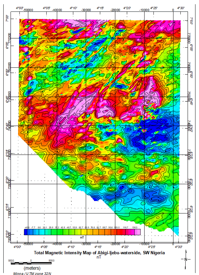
The results and geological interpretations of the processed aeromagnetic data of Ijebu waterside (study area) are presented in this section. The processed and gridded aeromagnetic data of Ijebu-waterside and environs is presented as the Residual Magnetic Intensity (RMI) map in figure 2. The map indicates short and relatively long wavelength anomalies, some of which are positive while others are negative. The positive magnetic intensities are regions of the study area having relatively high magnetic relief which correspond to regions with relatively high magnetic susceptibilities. The negative magnetic intensity areas on the other hand are areas of low magnetic relief corresponding to regions of relatively low magnetic susceptibility. Residual magnetic intensity distribution across the study area ranges from - 40 nT to 138.5 nT (Figure 2). The northern and considerable part of the central portion of the study area is dominated by high positive anomaly while the southern end displayed low negative magnetic intensity. This defines the area with high and low magnetic reliefs, respectively.
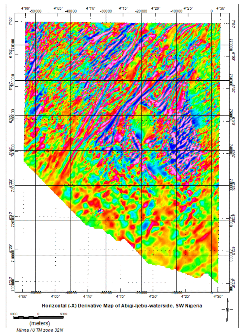
The extracted horizontal and vertical derivatives which were generated in order to enhance linear features such as fractures, faults and sheared zones are presented in figures 3, 4 and 6, respectively. The results indicate series of linear magnetic features, many of which are aligned along NE - SW directions. Some of preferentially aligned magnetic features as observed on the derivative maps correspond to linear geological features that generate the preferentially oriented magnetic anomalies.


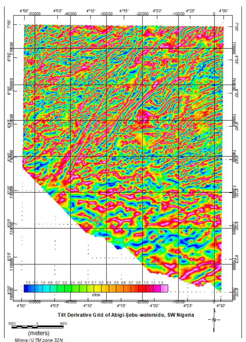
The tilt derivative and the total horizontal derivative of the tilt derivative grids are presented in figures 6 and 7 respectively. The figures present enhanced edges of linear features which may have originated from deep and shallow sources (Miller & Singh, 1994). The gridded maps of both tilt angle derivatives and total horizontal derivative of the tilt angle derivative like the horizontal and vertical derivative maps also indicate a number of linear features which show predominant alignment of regional and extensive linear structures along NE - SW direction. The tilt derivative grids present better resolved linear structures around Abigi - Ijebu waterside with many visible and better enhanced preferentially aligned patterns in the central part of the grid unlike those observed in the vertical and horizontal derivative grids. The summary of the structural analyses which consist of results obtained from derivative grids as well as tilt angle derivative and the horizontal derivative of tilt angle derivative grid is presented in figure 8 as the lineament map of the study area. The lineament map presents only linear features that appear to originate from deeper sources and also show regional trend, being up to 5 km in length. The trend and orientation of the extracted linear features from structural analysis of aeromagnetic data of Abigi - Ijebu waterside (Figure 8) correlates positively with the established NE - SW structural trend of southwestern part of Nigeria (Burke et al., 1976; Rahaman, 1976) as well as lineament map of southwestern Nigeria compiled from field observations during structural and geological mapping of the region.


Euler Deconvolution / Depth Estimation Results
Euler deconvolution depth weighting technique employed to determine depths to magnetic sources in the study area using different structural indexes (0.0 - 3.0), presented geologically reasonable solutions with structural index of 1, which represents contact and faults model (Reid & Thurston, 2014). The Euler solution proportional depth plots indicate shallow depth solutions (above the reference datum) to the magnetic source in the north while deep solutions characterize the south (Figure 9 a). The Euler depth solution distribution across the study area (Figure 9 b) indicates that the basement crustal rocks generally occur at about 100 m above the Minna reference datum in the northern part of the study area. The basement rocks gradually dips southwards as the crustal rocks get more depressed and deeper to create more accommodation for clastic sedimentary rocks at the edge of the Dahomey Basin. The basement configuration, allows the southern part of the study area, especially with continuous increase in depth to basement rocks southward, toward the Atlantic Ocean, to be overlain by relatively thick sedimentary rock units (in excess of 2 km). This implies that if the rate of basement depression presented by the Euler depth weighting of the onshore part of the Abigi-Ijebu waterside is maintained, projecting southward (offshore) beyond the area covered in this study, sedimentary thickness will exceed 3 km, few kilometers seaward into the Atlantic Ocean. The result of spectral analysis carried out on the aeromagnetic data of Abigi-Ijebu waterside as presented by the averagely power spectrum plot and the corresponding depth estimate (Figure 10) indicate shallow and relatively deep depth estimate results. The shallow depth results range from just above the reference datum to less than 500 m below the datum, while the relatively deeper depth result is more than 2000 m below the Minna datum. The shallow results represent the spectral analysis of magnetic data of regions where magnetic source (basement rocks) exit at the surface or very close to the ground surface which according to Euler deconvolution result coincide with the northern and part of the central portion of the study area. The relatively deeper depth as shown by the Euler solution is restricted to the southern end of the study area.
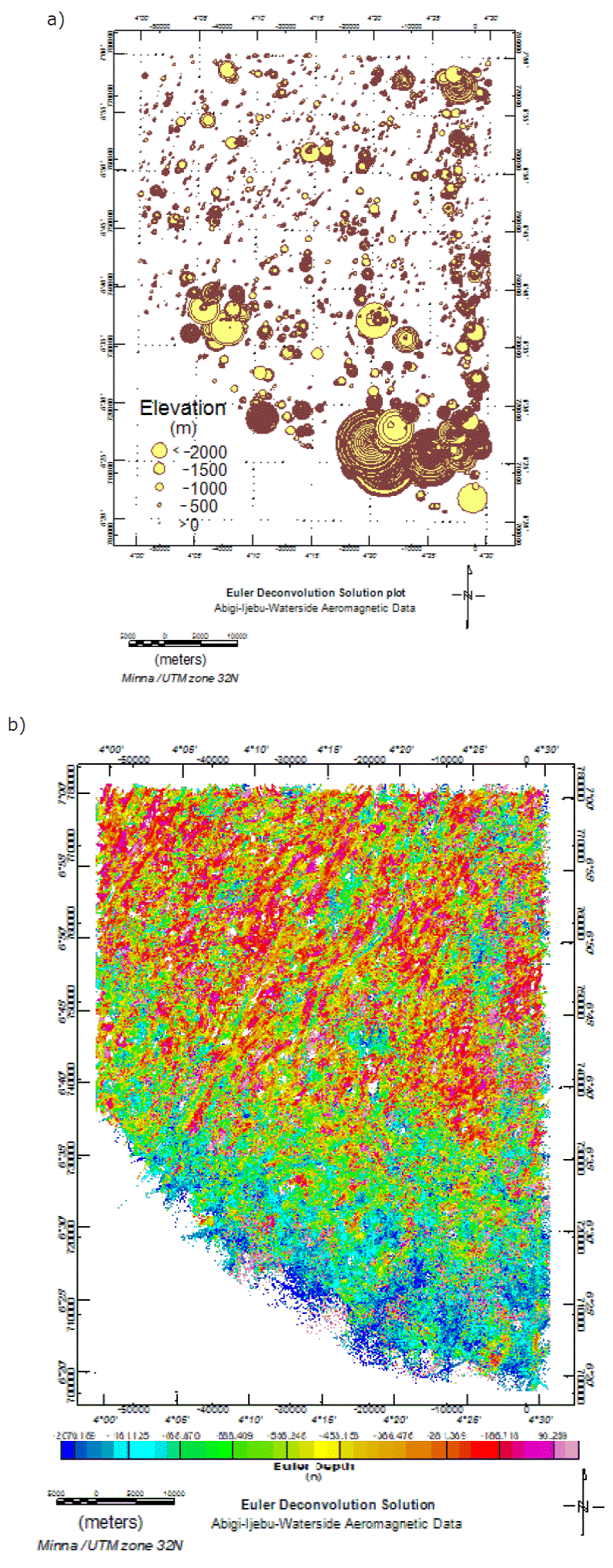
Figures 9 (a) Euler Solutions Depth proportional plots. (b) Euler Depth distribution across the study area (Structural Index (N) 0.1).

Discussion of Results
The various analyses carried out on the aeromagnetic data of Abigi - Ijebu waterside, as shown by the structural as well as the depth to basement mapping results indicate that the study area has undergone active tectonic activities in the past. This is evident by the numerous regional tending structural features, some of which are more than 15 km in length, in addition to the down warping basement geometry as shown from the spectral analysis and Euler deconvolution results. This unique basement characteristic is associated with sedimentary basin edge where the depression of the basement rocks (slab) began. This region is usually associated with numerous faults many of which could take the form of step faults or horst and graben in response to brittle deformation at the basin edge. Here the effect of associated flow/ductile deformation influenced by the magmatic activity that initiated the formation of the basin may be minimal.
Previous authors based on interpretation of some few wells and outcrop studies have described the basement topography of the eastern Dahomey Basin, which Abigi - Ijebu waterside belongs, as composed of a series of horst and graben structures (Omatsola & Adegoke, 1981; Olabode & Adekoya, 2007). The study area is a small section of the Dahomey Basin which was described to span 440 km in length (Francheteau & Le Pichon, 1972) and therefore represents a part in terms of structure and basement geometry. The results obtained through the analyses of magnetic data of the study area confirmed the occurrence of regional structures whose trend agrees with previous works. However the depth weighting results did not indicate sharp drop in depth characteristic of rifting which could support the horst and graben model around the study area, rather a gentle increase in depth from about 100 m above the reference datum in the north to around 2000 m in the south. The distribution of the Euler solutions points as well as the narrow range of data suggest a rather gentle step increment in depth to basement rocks that could be attributed to step faulting.
The integration of the obtained results from this study and previous studies such as the works of Francheteau & Le Pichon, (1972), Burke et al (1976), Omatsola & Adegoke, (1981), Olabode and Adekoya (2007) among others suggest that the study area may be part of the regional horst and graben structure but exhibit step faulting around the study area which causes the thickness of clastic sediment overlying the basement rocks to progressively thickens southward as the basement rocks dip southwards and the crustal slab get more and more depressed towards the sea.
This probably explains the reason for the occurrence of tar sands instead of oil and gas pools in the area. This is because oil and gas generation, accumulation and preservation require considerable depth, usually in excess 3 km, to guarantee the appropriate temperature and pressure conditions required for generation of hydrocarbon from organic matter as well as maintenance of the cap rock integrity for the preservation of the generated hydrocarbon. Where the thickness of the sedimentary unit is less than this minimum average, poorly matured organic matter as well as poorly preserved generated hydrocarbon will result which upon further exposure to the surface conditions such as biodegradation will generate bitumen, bituminous or and tar sands.
The discovery of commercial accumulations of hydrocarbon in the eastern and western offshore of the Nigerian sector of the Dahomey Basin, such as. Aje and Ogo oil and gas fields suggests the basement topography further south support the accumulation of up to 3 km of clastic sediment which is one of the most important petroleum accumulation and preservation requirements. This therefore points to south of the study area (into the deep offshore) as prospective area for petroleum prospect evaluation and development.
Conclusions
The analysis and interpretation of various enhanced, derivative and attribute maps generated from the high resolution aeromagnetic data of Abigi-Ijebu waterside in southwestern Nigeria revealed the distribution of crystalline basement rocks at considerable depth, identified structural framework as well as the basement topography which determines the thickness of sedimentary units overlying the Ijebu waterside region of the Nigerian sector of the Dahomey Basin. The structural framework as defined by the enhanced linear structures derived from the application of derivative filters indicate occurrence of regional linear structures, some of which are more than 15 km in length and generally trend NE - SW. The gradual increase in depth to magnetic source from about 100 m to over 2.0 km southward as obtained from spectral analysis and Euler deconvolution solutions indicate a gentle increase in thickness of the overlying sedimentary unit towards the south as the crustal rocks get depressed through the aid of regional faults which gradually step down the basement rocks southward toward the ocean. The basement geometry and structural framework point south of the study area, toward the offshore of the Dahomey Basin as the appropriate direction to focus hydrocarbon exploration energy since further basement depression and corresponding thickness of sedimentary rocks could support hydrocarbon generation and preservation.

