


 text new page (beta)
 English (pdf)
 Article in xml format
 Article references
 Send this article by e-mail
 Cited by SciELO
  Similars in
SciELO
Similars in
SciELO 
 Permalink
Introduction
In oceanography, it is often necessary to compute geostrophic currents in deep bays or high seas. For this purpose, the data from oceanographic surveys are often collected at sea on vessels equipped with a winch to lower a CTD profiler. In order to measure the temperature and salinity profiles at a fixed point in the ocean, it is necessary to stop the ship and spend valuable time to lower and raise the probe on board the vessel. It takes tens of minutes to an hour or more to obtain every cast in each station depending on depth. In an earlier study (Filonov et al., 1996a), a simple method to take a fast oceanographic survey using an undulating CTD was proposed, which could be applied from an unequipped ship or marine boat such as a panga without a winch, shortening the data acquisition time by a factor of 3-5 and certainly reducing costs.
In coastal seas it is well-know that the calculation of geostrophic currents should be taken carefully due to the variability caused by many factors, especially internal waves (Defand, 1950). These waves can cause the hydrographic measurements on the continental shelf to be considerably different depending on the tidal phase in which they were taken. Therefore it is important to carry out a quick survey to capture the internal waves in the ocean and their nonlinear transformation, change of amplitude, direction of motion and spectral composition (Filonov, 2010). This method has been used in many papers (Filonov et al., 1996a; Filonov, 2000; Filonov et al., 2005; Filonov et al., 2014 and others). In this paper, we propose the use of the method of fast measurements to obtain the geostrophic currents in a coastal oceanographic transect which is composed of a forward and a backward parallel section.
Method of measurement
The survey is commonly performed along a line perpendicular to the coast. The thermohaline structure is captured using a towed autonomous undulating CTD, placed in a special box with a hydrodynamic shape (Figure 1), which can take rapid vertical profiles while mostly underway. When the vessel is at full speed, about 15 20 km/h, the CTD skimmed the surface, then when the boat stopped for the cast, the profiler fell freely, to a depth determined by the length of the tow rope. When resuming to full vessel speed, the CTD surfaced again till the next station, and so on (Filonov et al., 1996). The method requires two parallel sections with the most nearly uniform spatial distribution of vertical soundings in forward and backward directions. The distance between casts can be typically 1-2 km. The navigation data logged can be made by means of a GPS. The survey can be taken very quickly. For instance, a survey taken in Banderas bay (~ 60 km long and 30 km wide) lasted nearly two days to complete more than 120 casts. That is, when the vessel reaches the measurement point, the undulating CTD sinks freely by its own weight. In our measurements this was at a rate of 1 1.5 m/s. Then, for a vertical cast is takes about 2-3 min, depending on the depth.
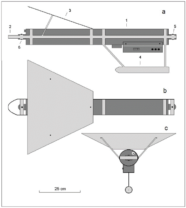
Figure 1 (a). Constructive scheme of an undulation CTD profiler (lateral view). Figures (b) and (c) show the plan and frontal views, respectively. The numbering means 1- CTD profiler SBE-19 plus or TDR XR-620. 2- The metal structure for fixing the profiler body. 3- A wing that generates lift during towing the vehicle. 4 - Directional keel to avoid rotation while towing. 5 - Bolts of fastening device to a metal structure.
The measurements used in this study were obtained by two types of CTD profilers: SBE-19 plus (http://www.seabird.com) and RBR XR-620 (http://www.rbr-global.com). The latter is preferable, as it is more easy to use (in water it weighs only 0.39 kg). The latter has a higher frequency of measurement (6 Hz sampling) and provides sufficient memory for 2,400,000 readings, which can be logged using one set of high-powered 3V lithium cell batteries. It is also important to implement into the XR-620, a RDB 6 Inductive sensor, which excludes "emission" of salinity values that ensures a smooth vertical profile. The logger range is able to support additional sensors to measure pH, dissolved oxygen, fluorescence, turbidity and transmittance (http://www.rbr-global.com).
Calculation of geostrophic currents
The geostrophic method is based on a simplification of oceanic dynamics, where the effects of friction, high frequency movement and lateral boundaries are neglected (Cushman-Roisin & Beckers, 2011). The balance is given only between the horizontal pressure gradient force and the Coriolis force:
Where (u, v) are the (eastward, northward) components of the velocity, ρ 0 is the reference density, p is the pressure and f is the Coriolis parameter.
For calculation of the geostrophic currents, the package GSW-TEOS10 (McDougall and Barker, 2011) was used, which transforms temperature and salinity to the new convention, and also estimates geopotential anomalies and geostrophic velocity, that is, the component of the average horizontal velocity that is perpendicular to the imaginary line that joins CTD casts relative to a level of no movement (Figure 2b). The entire set of raw hydrographic data were cleaned and smothered in order to use the GSW-TEOS10.
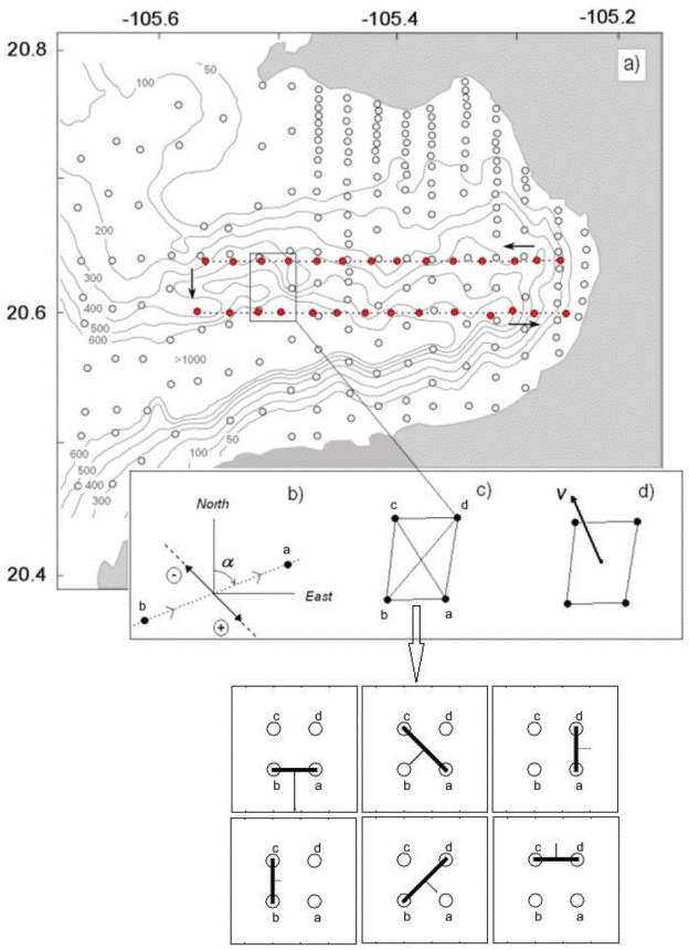
Figure 2 a) Position of profiles sounding made at Banderas bay on 16-18 October 2009. Open circles show the position of vertical sounding by undulated CTD profiler SBE-19 plus. Red circles show the two lines made to validate this methodology. b) Scheme of measurement the component of geostrophic flow between two vertical soundings. The thick arrows show the positive and negative components of the geostrophic flow, perpendicular to the direction of the section. c) Four points to determine the geostrophic vector and the corresponding section for each pair. d) Average vector of geostrophic current obtained from the calculation of six components perpendicular the lines: ab, ac, ad, bc, and cd.
It is clear that with one oceanographic transect in the sea, only one component of the geostrophic flow is retrieved perpendicular to that section. If two parallel transects are conducted, then two components can be obtained from the quadrilateral set formed between both transects (see Figure 2a, 2c).
Depending on the angle between the north (or east) and the direction of the survey (Figure 2c), the geostrophic currents will be analogous to eq. (1). As a result, the parallel transects allow for the estimation of the module and horizontal direction of currents for a chosen level within any quadrilateral formed by the four nearest vertical soundings, as shown in Figure 2c, d. In this simple case, the number of combinations of any quadrilateral set taken as two points can retrieve up to six sections (see Figure 2c).
In each pair of vertical soundings, the coordinates can be obtained by a GPS to find the angle α between the north (or east) and the direction of the transect line. After that the components of the geostrophic currents are obtained between each of the six pairs of casts: ba, cd, ad, bc, ca and bd, shown on Figure 2c, where the obtained values of the currents were projected onto their corresponding coordinate u (east) and v (north) , and the final horizontal vector of geostrophic currents is obtained as the vector average of components in the center of mass of each quadrilateral set (Figure 2d).
Filtering out the fluctuations caused by internal waves
The dynamics of water masses on the continental shelf of the Mexican Pacific coast is affected by barotropic and baroclinic tides. Internal tides are known to cause significant vertical variations in all the hydrophysical parameters on the continental shelf. Defand (1950) first showed that internal tides may cause the temperature and salinity measurements on the continental shelf to provide different results with respect to the geostrophic currents, depending on the tidal phase in which they were taken.
Filonov et al. (2000) proposed a method to conduct a rapid oceanographic survey with an undulating CTD in a grid of numerous and successive casts that would allow them to filter out the data to remove the influence of internal waves. In this study, we employ the filtering method proposed by Filonov (2000), which is based on smoothing the fields of temperature and salinity with a filter whose parameters are determined by the shape of the spatial correlation function of the field's pulses. The filtering method was successfully tested using data from rapid oceanographic surveys during measurements in different areas of the Mexican continental slope (Filonov, 2000; Plata et al., 2006; Filonov, 2011; Filonov et al., 2014).
Results and discussion
The validation of the proposed method was checked out using the data from two parallel transects made in October 2009 in the central part of Banderas Bay. From these data, the average of geostrophic currents in the 10 m layer were found referenced to a depth of 200 m. The corresponding vectors for these currents are shown in Figure 3. In the same figure, the pressure anomaly distribution of the bay and the surface geostrophic currents calculated from a regular mesh using objectively mapping according to the spatial oceanographic survey in October 2009 is shown (see Figure 2). The surveys was carried out using the undulating CTD SBE-19 plus.
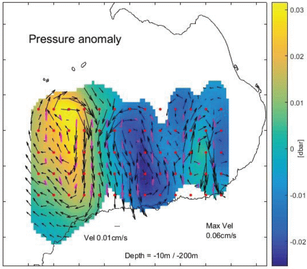
Figure 3 Field of geostrophic currents velocities computing with objective mapping (black arrows) vs. vectors of geostrophic currents (magenta vectors) generated with the proposed method at different sections. The background color represents the ocean pressure anomaly at 10 m depth, measured 16-18 October 2009. Note that every quadrilateral formed is a subset of the total set of observations. Only CTD casts greater than 200 m were considered.
The current pattern comprises an alternating movement from north to south directions along the whole transect. The most intense currents reach 0.06 cm/s near the west end of the transect (entrance to the bay). At the inner section of the bay, the currents present slower speeds (around 0.01 cm/s). From surface and below (not shown), within the first 50 m, the currents present speeds of 0.04 cm/s, whereas below that, from 50-100 m, the intensity decreases almost 30% (0.02 cm/s). This behavior is due to the position of the thermocline within the bay, which typically lies around 40-50 m deep.
To quantify the error, the normalized root mean square error was computed from
Where U
g
corresponds to the computed geostrophic velocity, U
obj
is the geostrophic velocity from objectively mapping, N the
total station in a specific level, and
As in earlier studies (Pantoja et al., 2016), the circulation of the bay constantly presents the formation of 2-3 vortices with diameters of 15-30 km, located along the axial line of the bay because of the deep submarine canyon. The eddies are formed due to the interaction of the local topography (the southern and northern capes, and the submarine canyon) with jets of the Mexican Coastal Current that penetrates into the bay from the south. At the early stage of the eddy generation, the nonlinear components of the advection are dominant, but once the jet of the Mexican Coastal current ceases, geostrophic currents form a well-defined structure into the bay that remains up to 15 days. In the upper layer (at least above 500 m) the currents can be considered in geostrophic balance, yet below this depth the currents obey a direction given by the pressure gradient force due to the narrowness of the canyon.
Conclusions and final Remarks
As it is known, CTD cast cannot be used to compute geostrophic currents when they are shallower than 100 m. Fortunately along the Mexican coast, there are several regions (as in other places around the word) where the continental shelf is narrow and one can reach the 200 m isobaths around 5-8 km offshore, where the geostrophic circulation can be computed without the variability present close to the coast (see for example, Obeso-Nieblas et al. (2014) in Bahía de la Paz, and Salinas and Pinet (1991) in Bahía Magdalena). Also, since internal tides are known to cause significant vertical variations in all the hydrophysical parameters on the continental shelf, we suggest a separation between casts should be at least 1 and 2 km to avoid further misinterpretation of the hydrography data due to the presence of internal waves which with an additional treatment can be filtered out with one of the methods mentioned in section 3.2.
Therefore, the proposed method is recommended for rapid measurement of the thermohaline structure of the sea from a marine boat (working at sea during daylight hours) and the subsequent calculation of geostrophic currents in the remote areas of the Mexican coast, where there are no specially equipped oceanographic ships. This method cannot be used in coastal zones, but in deeper waters where the geostrophic current implies length scales of the order of tens to hundreds of km. In the case of the present study, the region is a small scale bay (Banderas Bay), where the currents have been described as being stable with patterns that are persistent and well-structured due to the deep submarine canyon. In other coastal sites, as in the open seas, the geostrophic current might have much more variability and perhaps this method must be applied cautiously as the regional coastal current pattern might or might not be extrapolated providing realistic currents. However, as a first approximation this method can be used with confidence for a rapid view of observational outputs.

