


 text new page (beta)
 English (pdf)
 Article in xml format
 Article references
 Send this article by e-mail
 Cited by SciELO
  Similars in
SciELO
Similars in
SciELO 
 Permalink
Introduction
In areas with potential sources of contamination and crossed processes of soil and groundwater contamination, it is necessary to implement planning and management tools that allow sustainable policies of exploitation water resources. If there are not surface water bodies and agriculture and industrial processes require great volumes of water, groundwater becomes a valuable resource.
In Guanajuato State, Central Mexico aquifer vulnerability assessments were promoted as additional criterion to prevent and/or to avoid groundwater quality alterations because groundwater is the only source of urban and rural water supply of many cities, like Juventino Rosas and Salamanca, an important industrial centre (SEMARNAT 2013) (Figure 1). Guanajuato is the only Mexican State with vulnerability assessments, mathematical flow models and monitoring well networks in each regional aquifer (Marañón 2010).
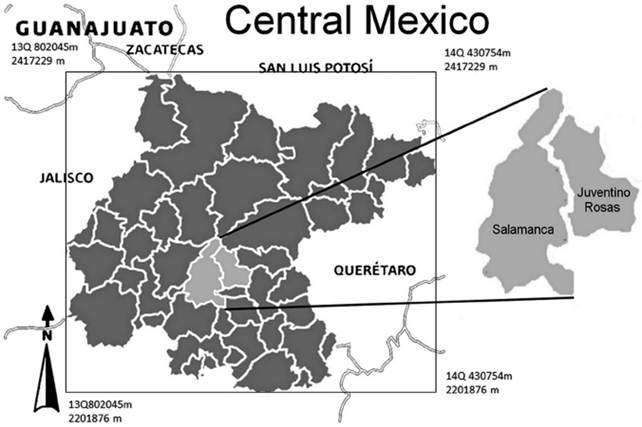
Salamanca uses only groundwater for all uses. There is an industrial zone; a refinery, a thermoelectric plant and until 2008 an agrochemical plant that produced DDT generated contaminants (Rodríguez et al., 2000; Rodríguez et al., 2001; Rodríguez et al., 2002). In Salamanca, arsenic, (As), and vanadium, (V), concentrations from natural origin and locally from anthropogenic origin have been reported in the local aquifer system (Rodriguez et al., 2000; Rodriguez et al., 2001; Rodriguez et al., 2015). Vanadium does not represent considerable environmental concern. In the study area groundwater V is originated by infiltrations that carry V contained in particulate emitted by industries using fuel oil number 6 (locally called combustoleo), when the electrostatic precipitators do not work. This fuel has high vanadium contents of 290 to 500 ppm (Salinas et al., 2001). Late 2004, particulate emissions deposited on soils were analyzed. High V concentrations were detected, 2.09 g/Kg (LAQUIMIA 2004). During combustoleo combustion V is released to the atmosphere as V2O5 in fine ashes suspended in the air. The V content in these emissions varies from 1 to 18 % (WHO 2000). Other authors have measured similar values (Mendoza 1999; Mata, 206; Hernandez et al., 2007). Particulate is deposited over vulnerable areas and then migrates to the shallow aquifer (Mejía et al., 2007).
In Salamanca, the intense extraction regime results in subsidence, being its mean velocity 6-7 cm/year (Rodríguez et al., 2002). The subsidence produces two faults; one of them crosses the urban area and refinery lands affecting the urban infrastructure (Rodríguez and Rodríguez, 2006). The faults can facilitate the migration of surface contaminants.
In Juventino Rosas, an agricultural community with some additional incomes from goat cheese production, high concentrations of arsenic and fluorine has been detected in the regional aquifer (Rodriguez et al., 2001; Mendoza 1999). Vanadium concentrations are lower than the detection limit. The origin of them is geogenic and related to the geological framework and to the geothermal activity observed in some parts of the aquifer (Morales et al., 2015). Groundwater temperature varies from 25.5°C to 50°C. The highest temperatures are located near faults and fractures. High temperatures match with the highest groundwater concentrations of As and F concentrations. In hydrothermal systems the solubility of some minerals increases (Eugster, 1986).
The main environmental risks associated to arsenic and fluorides are health affectations of the exposed population. The more risky exposition route is water ingestion, even more than ingestion of food with higher As and F concentrations. Arsenic health affectations include skin alterations, cardiovascular problems and cancer in different organs, and for fluoride, dental fluorosis and/or skeletal fluorosis.
The origin of some risky elements can be proposed through the knowledge of local and regional groundwater background values, GBV (Reimann and Garret 2005). Concentrations in pristine areas can define the natural, geogenic levels of some element while higher concentrations could be related to anthropogenic interventions. Anomalous concentrations allow the identification of potential contaminant sources and even contaminant migration mechanisms. The determination of GBV in Salamanca can help to define the extension of the zones affected by anthropogenic contamination sources like particulate and/or to know when an urban well is being contaminated. In Juventino Rosas GBV can be used to define if falls are contributing with ascendant flows rich in elements like arsenic altering the local hydrochemistry, as occurred in Rancho Nuevo, Apaseo El Alto, no far away from J. Rosas where suddenly appears a geothermal manifestation with water rich in arsenic and temperature greater than 65° C.
Two tectonic events affected the whole area. The first one is related to the Laramide Orogeny, whereas the second was an extensional phase with intense magmatism (Ferrari 2000; Cerca-Martínez et al., 2000). Both events originated faults and fractures in the area. These faults allow ascendant geothermal flow that can contain elements like fluorine, lithium and radon (Morales et al., 2015; Rodríguez et al., 2015). In Guadalupe, a neighborhood located 4 km SW of J. Rosas, there are subsidence manifestations. A subsidence fault due to the abstraction of a local well produced a differential terrain displacement of 3.6 m in 6 years, one of the highest in Central Mexico (Rodríguez et al., 2002).
Methodology
A monitoring sampling was carried out in both study areas, Salamanca and Juventino Rosas. In Salamanca groundwater samplings were carried out in Jul 2003, Feb 2004, Jun 2004 , Apr 2005, Aug 2005, Nov 2005, Aug 2006 and Sep 2006. In J. Rosas sampling were collected in May 2010, August, 2011, October 2012, March 2013 and June 2013. Samples were collected as described by Mexican standard (NMX-AA-132-SCFI-2006). Groundwater samples were analyzed in the Chemical Analytical lab of the Geophysics Institute of the National University of Mexico, UNAM. Formal EPA and CNA (Mexican National Commission of Water) protocols for sampling and analytical procedures were applied (APHA-AWWA, 2005). Arsenic was measured by atomic absorption spectrometry with hydride generation, Fluorine by potentiometry with selective electrods and vanadium was analyzed in the water colorimetrically by measuring the extent of oxidation of gallic acid (APHA, 1995).
Twenty five urban wells were monitored in Salamanca, white 23 were sampled in Juventino Rosas. For the purpose of this research only As, F, and V were considered. The use of other hydrochemical methods or graphic information as Piper, Schoeller or Stiff diagrams do not contribute in the definition of GBV.
Evaluation of a single aberrant or inconsistent value using Dixon and Grubb test Dixon's Q test for the rejection of outlier values
A test for outliers of normally distributed data which is particularly simple to apply has been developed by Dixon (1951). This test is eminently suitable for small sample sizes; for samples having more than 30 data the test for significance of Pearson and Hartley can be used as well. In order to perform the Dean- Dixon test for outliers, the data set containing N values has to be sorted either in an ascending or descending order, with x1 being the suspect value. Then the test statistic Q is calculated using the equation.
The decision whether x1 is an outlier is performed by comparing the value Q to the critical values listed in tables, where N is the number of observations and α is the level of significance: If the calculated value of Q is greater than the critical threshold the corresponding data value x1 is regarded to be an outlier.
Dean and Dixon suggested a more elaborate approach by using different formulas for different sample sizes in order to avoid the problem of two outliers on the same side of the distribution (Dixon 1953). They defined the following ratios and recommended that various ratios be applied as follows: for 3 <= N <=7 use r10; for 8 <= N <=10 use r11; for 11 <= N <= 13 use r21, and for n >= 14 use r22:
Tables proposed by Dixon (1953) show the critical values for r11, r21, and r22, respectively. R 10 is equal to Q.
Two of the statistical tests most often used in a group of unique data set are the proof of Dixon and the Grubbs test. Dixon test uses relationships between data spaces in different ways depending on the number of values in the data set. This value is compared with a critical value from a table, and the value is declared outlier value if it exceeds the critical value. The critical value depends on the sample size, n, and a level of representation chosen. The table usually uses low levels of representation such as 1% or 5%. (Dixon 1953).
Grubbs test uses a statistical test, T, which is the absolute difference between the outlier value X0 and the average of the X sample divided by the standard deviation of the sample, s.
Background values of Arsenic, Fluoride and vanadium in Salamanca and Juventino Rosas
Threshold values or Background values are reference concentration values of solutes that present a great probability to be systematically in an aquifer system without any anthropogenic influence. There are two types of background values; natural and environmental. The first correspond to geogenic concentrations related to the regional predominant rock and the water rock interactions, whereas the second corresponds to elements related directly or indirectly to an anthropogenic influence. Then GBV can be also divided in natural and no-natural. GBV are representatives only of a region and cannot be attributed to any recognized natural source of contamination in other areas (NREPC, 2004).
GBV are defined for areas with specific characteristic where can be identified the geological composition of the aquifer and the factors that control local and regional hydrodynamic. GBV cannot be assigned to all the aquifer system unless the aquifer presents homogeneity in its geological composition and a similar hydrodynamic behavior in its entire domain.
GBV are determined by means of an analytical data set representative of an area. Data are collected or selected from reliable historical archives (Runnells et al., 1992). There are several methodological proposals for GBV calculation. Before data management is carried out, the appraisals of outliers with Dixon's Q test rule out values that do not correspond with the rest of group values. In this case it was observed that the calculated values not exceed the values of tables and that data was rejected. The Environmental Protection Agency from US uses the Grubb Test to choose the concentration values to get a representative mean value (USEPA, 1988). Breckenridge and Crockett (1995) have used variation coefficient values (relationship between standard deviation and mean value) smaller than 0.5 to define the data set to be used.
The GBV are concentrations that vary from 10 % to 90 % of the percentiles of concentration distribution from the chosen data set (Kunkel et al., 2006). When the number of data is great, hundreds of data, regression or clusters analysis can be useful to get representative GBV (Vyas et al., 2001).
The GBV are not necessarily related to standards for any water use. The GBV for a risky element can be higher than the maximum concentrations recommended for potable water or other specific use. This situation occurs with arsenic concentrations reported in some aquifers (Hernández-García and Custodio, 2004; Armienta et al., 1997). When the GBV can be considered natural, it can be taken like pristine concentrations in areas where some elements can be originated from anthropogenic sources.
The Water Framework Directive of the European Union considers that in the definition of GBV must be included not only the aquifer characteristics but also the characteristics of the solute and water receptor bodies too (Muller et al., 2006).
In Salamanca all the chemical analyzes were reviewed to choose only data obtained with the same analytical methodology. A data set was compiled and used for GBV determination.
The area was divided in Northern, Central and Southern Zone. The Lerma River that crosses the urban area is acting as a hydraulic barrier and a natural frontier. The division took also in consideration the geological composition of the aquifer (to the North prevail sedimentary units of variable granulometry like sand, gravels and clay, whereas to the south volcanic rocks; basaltic flows, fractured basalts and volcanic ashes). A shallow aquifer unit is located in the Central zone. The Northern zone is a relatively pristine area, without the influence of the industrial area (Figure 1).
In JR the area was divided in three zones; NW zone with volcanic basaltic and ignimbrite- rhyolitic rocks: NE zone with volcanic ignimbrite- rhyolitic and sedimentary rocks and Southern, S, zone in the sedimentary plain. The division took in consideration the geological composition of the aquifer (to the North volcanic rocks; basaltic and ignimbrite-rhyolitcs flows, fractured volcanic rocks and ashes, whereas to the South prevail sedimentary units of variable granulometry like sand, gravels and clay the mainly igneous origin, interbeded with volcanic material as rhyolite and basalt). The Northern zones are relatively pristine areas. A shallow aquifer unit is located in the South zone. It is not excluded the influence of the agricultural activity.
The well Dulces Nombres, DN, was put in the NW zone, whereas the wells Val 1 and Val 2 in the zone S, although they are very close to each other. The well DN was drilled in rhyolites (Tom) and the wells Val 1 and Val 2 in volcanic sediments. The faults could be working as natural hydraulic conducts whereby hot water with other composition that infiltrated water can circulate. The hot water can alter the natural composition of the aquifer water.
Notwithstanding the Wells 9, 10 and 13 are located in the plain there are hydrochemical differences between them due to geological heterogeneities. The well 10, in the S zone, is intensely exploited for urban supply. It is one of the hottest wells that could be an indicator of a fault not mapped. The wells 9 and 13 were put in the NW zone because their hydrogeochemical behavior indicate that part of the well is extracting water from some rhyolitic unit.
The data set from Salamanca is formed by 51 files of 25 wells. Average and standard deviation, SD, were obtained for each well. The data set from Juventino Rosas is formed by 91 data files of 23 wells. Well distribution for Salamanca is showed in Figure 2: The Northern Zone is represented by 6 wells; the central zone has 8 and the southern zone comprises 11. Well distribution for Juventino Rosas is showed in Figure 3: The NW Zone is represented by 9 wells; the NE zone has 4 and the South zone comprises 10.
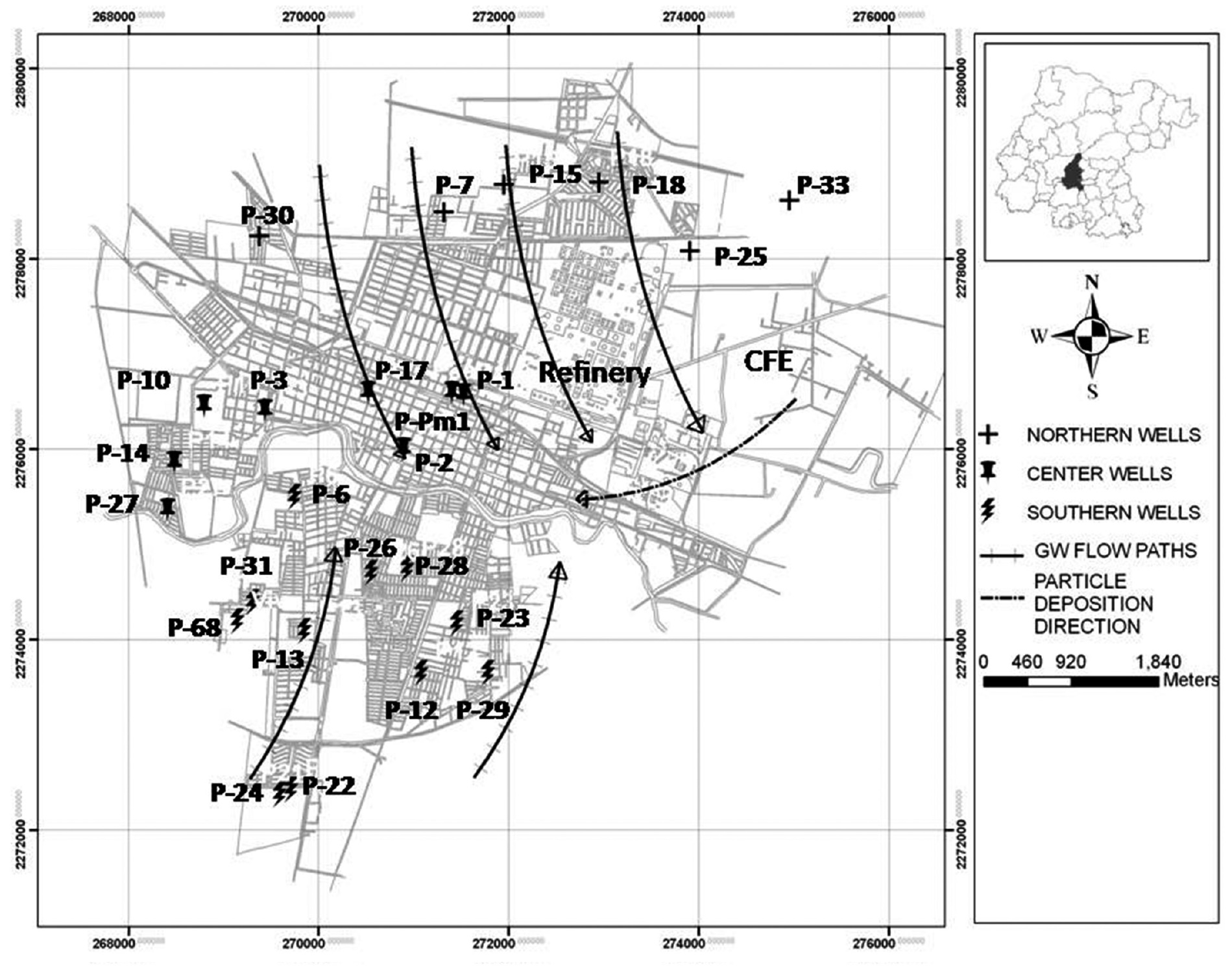
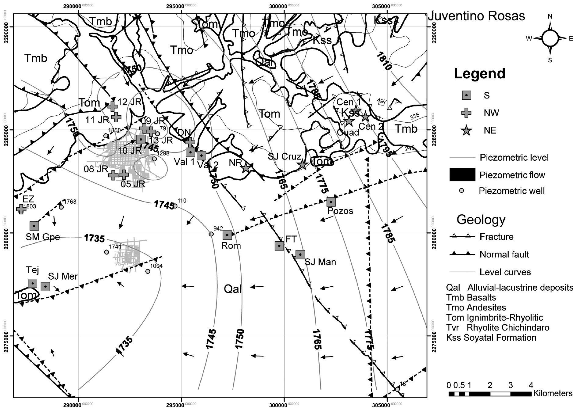
Figure 3 Wells and BVG zoning in Juventino Rosas, Gto. EZ= Emiliano Zapata; SM Gpe= Santa María Guadalupe; TEJ= Tejada; SJ Mer= San José Meríno; JR= Juventino Rosas; Val= Valencia; DN= Dulces Nombres; NR= Nuevo Rocillo; Cuad= Cuadrilla; Cen= Centeno; SJ Cruz = San José Cruz; Rom = Romerillo; FT= Franco Tavera; SJ Man= San José Manantiales.
Results
Some of the detected concentrations are greater than the Mexican standards for drinking water (Figure 4). In the S zone of Salamanca, all wells have far exceeded the national standard for drinking water (Figure 2). The highest concentration was 0.076 mg/L in the well P 21. In the N zone, the As values were greater than the national standard, with a maximum in the well P 30, 0.777 mg/L. The wells of the central zone, (C), also had concentrations over the standard with a maximum of 0.068 mg/L in the well P 2. The maximum value of vanadium in the S zone was 0.091 mg/L in the well P22. For the N zone the greater concentration of V was detected in the well P30, 0.062 mg/L. In the central area, the well P 10 had the highest V concentration, 0.065 mg/L.

The NE zone of Juventino Rosas of the wells exceeded the national standards for As and F. In the NW zone the wells JR 05 and JR 08 had concentrations over the As standard. The maximum value was found in the well JR 05, 0.036 mg/L. In the S zone, the wells Rom, Tej, Val 1 and JR 10 had values over the standard with a maximum in the wells Pozos and JR 10, 0.046 mg/L. The wells Tej, Val 2, Rom, Pozos, JR 10 and SJ Mer exceeded the standard for F; the highest value was 2.95 mg/L in the well Tej.
Three set of mean values with its SD were calculated. The Grubb Test, (Z), was applied to each data set. If Z is greater than the table values for N data, the respective well is excluded of the data set because the concentration does not correspond to a normal distribution. The Grubb Test considers the mean, the SD and the concentration value for each well (NREPC, op cit).
The obtained results for Salamanca show that (Table 1) for the Northern and southern zones the GBV for arsenic are greater than the Mexican standard for drinking water, 0.025 mg/L. In the Central zone the GBV is lower, 0.023 mg/L.
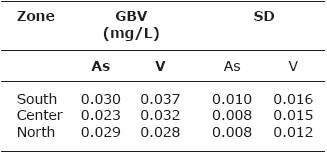
Vanadium has not standards for drinking water in Mexico even EPA does not consider it in the Secondary standards. The lowest values, 0.028 mg/L, were found to the North increasing the concentrations to the south reaching 0.037 mg/L.
The obtained results for Juventino Rosas show that (Table 2) for the S zone the GBV for arsenic are at the limit of the Mexican standard for drinking water, 0.025 mg/L. In the NE and NW zones the GBV are lower than the Mexican standard, 0.003 and 0.013 mg/L.

For the S zone the GBV for Fluoride, 1.93 mg/L, is greater than the Mexican standard for drinking water, 1.5 mg/L. The lowest values, 0.81 mg/L, were found to the NE increasing the concentrations to the NW1.19 mg/L.
In 2009 some wells of Salamanca were sampled founding similar values for As and V in the South-western Zone (Rodriguez 2009). In piezometers located in the industrial area, greater concentrations than the GBV (obtained in this work) were found (Hernandez et al., 2007). The increase can be related to contamination processes due to the particulate deposition described above (Mejia et al., 2007). The particulate can fall and be deposited over the terrain and then can be incorporated to infiltrations of rain water or pipeline leakages.
In urban wells in Irapuato City, 20 km North-West Salamanca, V mean concentrations are 0.022 mg/L and for As 0.017 mg/L (lower than the GBV found in Salamanca). Although in "El Copal" a small community out of the Irapuato urban area Arsenic concentrations of 0.33 mg/L have been reported (Rodriguez et al., 2006).
The As and F- concentration in Juventino Rosas, occurs naturally in the aquifer by hydrogeochemical phenomena, but an anthropogenic contribution cannot be discarded. It is observed that some natural background values, especially for the area S, are above the values allowed by the NOM-127, consequently the site is of inadequate quality water for human consumption.
The processes controlling the release of As and F in Juventino Rosas groundwater
In Juventino Rosas the water temperature is above 36° C to 50° C on surface, Na-HCO3 - and Na-Ca-HCO3 - rich hydrothermal waters are formed by the interaction of thermal fluids with the host-rock (Morales et al., 2015). Regularly As and F- concentrations are higher in geothermal systems (Giggenbach, 1981). Due to hydrothermal and supergene processes that occur in different parts of Juventino Rosas, progressive alteration processes and formation of new mineralogy were observed, mainly in volcanic material of ignimbritic and rhyolitic composition. The excess of F- and As, and low Mg2+ and Ca2+ could be a response to exchange processes between rock and hydrothermal aqueous fluids (Ellis and Mahon, 1964).
Grondwater wells with high temperature (24-48°C) are common in Juventino Rosas area. Deep faults and fractures systems are observed in the area (Figure 3), in addition, the geological background and the aquifer overexploitation due to the intensive use of groundwater for agriculture and urban supply, originated subsidence faults and fractures that can act as preferential channels for recharge and also for ascendant geothermal water. Faults and fractures can allow the migration of hydrothermal flows with As and F to surface. The hottest wells are located very near of faults. The zone S presents the highest As and F concentrations; in this area there are the greater number of hot wells, also there are a fault and fracture system with NW-NE orientation. The zone S corresponds to a basin with rhyolitic volcanic sediments. These rocks have arsenic and fluorine minerals. The fault and fracture system controls the geothermal water circulation. Groundwater accelerates the weathering processes of the silicate minerals originating high Na and HCO3 - concentrations and the mobilization of As and F.
Proposal of groundwater planning and management for Salamanca
The Water Framework Directive supports the idea to use GBV to guarantee that no affectations to population and groundwater dependent ecosystems are produced (Grima et al., 2015). GBV of well characterized aquifers can be an important tool to define management policies of aquifer systems mainly around urban areas and/or industrialized zones. One of the objectives of the BRIDGE project is to define methodologies to get groundwater background values (Hinsbyetal, 2008; Edmunds et al., 2008; Muller et al., 2006a; Muller et al., 2006b). In Mexico some isolate efforts were made to that respect (Cardona et al., 1993).
In areas where subsidence phenomena occur, fractures and faults appear, increasing locally aquifer vulnerability. If in such areas there are soluble contaminants, these can be migrate to shallow aquifers. This is occurring in Salamanca and Juventino Rosas as well in Irapuato City, where more than 18 subsidence faults have been reported (Rodriguez, 2006).
Particulate normally is not considered as potential source of aquifer contamination. Most studies have considered it as an atmospheric pollutant. There are recent studies about its role of health risk for the population living in areas with aggressive particulate (Gallus et al., 2008; Tadjine et al., 2008). The particulate generated by burned "combustoleo" contains important concentrations of arsenic, vanadium, nickel and zinc, between other risky elements (besides sulfur compounds).
Once deposited on the soil some particulate elements are susceptible to migrate to permeable formations. They can migrate with rainfall, irrigation water or leakages from sewages or potable water pipelines. The groundwater vanadium concentrations are lower in the pristine areas (North area) than in the central and southern ones in Salamanca (Figure 2). The latter could be affected by particulate deposition.
GBV allow differentiating in an easy way if measured concentrations are normal, from geogenic origin, or if they can be related to some anthropogenic process. The correlation between vulnerable areas, potential sources of pollution and GBV by area, allows a preliminary definition of a contamination process.
In Salamanca the found GBV corresponds to the local background altered by the slow incorporation, during at least 50 years, of risky elements infiltrated from particulate or inadequate waste disposal sites.
In Juventino Rosas the found GBV are related to natural hydrogeochemical processes that occur in the aquifer, the presence of faults and fractures allows the migration of hydrothermal fluids that increases the presence of As and F, mainly in the S zone.
GBV and aquifer vulnerability assessments can be incorporated in urban land planning, in the definition of protected areas, to locate adequate points for groundwater monitoring wells or for urban wells for urban supply. Water and environment stakeholders can be use them in projects aiming for sustainability.
Institutions in charge of Water at national level, CONAGUA (National Commission of Water), to state and municipal level must have information regarding quality aspects like analytical results, potential sources of contamination and solutes related to all identified potential sources. In developing countries the use of GIS is not so extended as in developed ones. In a GIS it is possible to put together, GBV zoning, aquifer vulnerability assessments, geological maps, mathematical models scenarios, water assigned volumes and even more. All this information can improve water administration and management in an integral and sustainable way.
Discussion and Conclusion
Salamanca and Juventino Rosas, JR, are located in an almost similar geological environment. However, the aquifers in both areas show some differences, while in JR there are low-temperature manifestations, in Salamanca there are not. The volcanic basement in Salamanca is located to a greater deep than in JR (Rodriguez et al., 2001). Most of Salamanca wells are placed in lacustrine and fluvial sediments whereas in JR some wells were drilled in heterogeneous sediments and in volcanic rocks. The faults in JR allow deep flow contributions to the aquifer system altering the local hydrogeochemistry.
The differences between both areas propitiated that the GBV may not be similars. In Salamanca in the three defined zones, the As GBVs are greater than in the JR zones (Figures 2 and 3). The As concentrations varies spatial and temporally. The very low F concentrations in Salamanca allow suppose that the F in JR can be associated to the geothermal flow.
The highest values obtained in the S zone of Salamanca were expected since this area corresponds to the deposit of particulate enriched in these elements (As and V) (Rodríguez et al., 2002). Is quite difficult to define which origin is most important.
In JR there are not anthropogenic sources of As and F. Both elements are of geogenic origin. The geogenic sources can be two; the As and F-bearing rocks, mainly volcanic rocks, rhyolites, and As and F in the hot deep flow. The existence of vertical ascendant flow along the faults was been verified by a piezometric dome in the center of the plain (Morales et al., 2014.

