


 text new page (beta)
 English (pdf)
 Article in xml format
 Article references
 Send this article by e-mail
 Cited by SciELO
  Similars in
SciELO
Similars in
SciELO 
 Permalink
Introduction
A detailed analysis of the relatively small earthquake of 6 September 6 1997, which occurred near Coatzacoalcos-Minatitlan, Vera- cruz, is of interest because of three reasons. First, the surface and the near-surface infor- mation from volcanic alignments, borehole elongations, and unpublished PEMEX seismic sections points to active normal-faulting in the region (Suter, 1991). The focal mechanism of an earthquake which occurred nearby on 26 August 1959 (M w 6.4), however, shows thrust faulting at a depth of about 26 km (Suárez, 2000; see Figure 1). It is, therefore, of interest to know whether the 1997 earthquake follows the same trend, confirming a change in the stress regime with depth in the region. In most regions, the stress regime at relatively shallow depth agrees with that at mid-crustal depth. There are some exceptions (see, e.g ., Zoback and Zoback, 1991) and one such exception appears to be the coastal plains of the Gulf of Mexico (Frohlich, 1982; Zoback and Zoback, 1991; Suter, 1991).

Figure 1 Earthquakes in and near Gulf of Mexico with known focal mechanism. Source parameters of the events are listed in Table 2. Focal mechanisms show that the mid- and lower crust of the Gulf is under compressive stress regime. Dotted lines indicate the bathymetry of the Gulf and gray dashed lines denote the limits of the buried salt deposits. LVPP = Laguna Verde Power Plant.
Second, the earthquake of 26 August 1959 caused serious damage to the towns of Jaltipan, Coatzacoalcos, and Minatitlan (Figueroa, 1964; Rosenblueth, 1964; Reséndiz, 1964). The latter two towns have now become important industrial centers, related to the intense activity of PEMEX, the national petroleum company. For this reason, it is important to estimate ground motions that may be expected in these towns if an earthquake, such as that of 1959, were to recur in the region. We may use the records of the 1997 earthquakes obtained at the near-source broadband station of TUIG as empirical Green's function to simulate the corresponding motions from an M w 6.4 event. Although the station is about 25 km SE of Coatzacoalcos-Minatitlan, the geology of these sites is roughly similar so that the results for the TUIG site may be valid, to a first approximation, for the entire region for an earthquake at about the same focal distance as the event of 1997 from TUIG.
Finally, a study of the 1997 earthquake (and other events in and along the Gulf of Mexico) has important bearing on the seismic safety of Laguna Verde nuclear power plant (Figure 1) and hydrocarbon exploration and production units in the region.
Data and analysis
The 1997 earthquake was recorded by the local broadband station of TUIG (S -P time = 5 s) and by seven other broadband stations of the National Seismological Service (SSN), which were located at epicentral distances greater than 260 km. The reported coda-wave magnitude, M c , is 4.3. The epicenter of the event, given by the SSN, is 18.146°N and 94.499°W. However, its depth could not be constrained in the location. The epicenter and depth reported by the National Earthquake Information Service (NEIC), U.S. Geological Survey, is 18.017°N and 94.396°W and 33 km, respectively. This depth was fixed in the location of the earthquake.
For moderate Mexican earthquakes it is now possible to obtain a regional centroid moment tensor (CMT) solution using relatively long-period regional waveforms (see, e.g. , Pacheco and Singh, 1998). Unfortunately, the seismograms of the 1997 earthquake show little energy at periods greater than 10 s because of its relatively small magnitude. At shorter period, a detailed three- dimensional crustal structure is needed to model the observed seismograms, which is currently lacking for the region. For these reasons it was not possible to obtain CMT solution by inverting the regional waveforms.
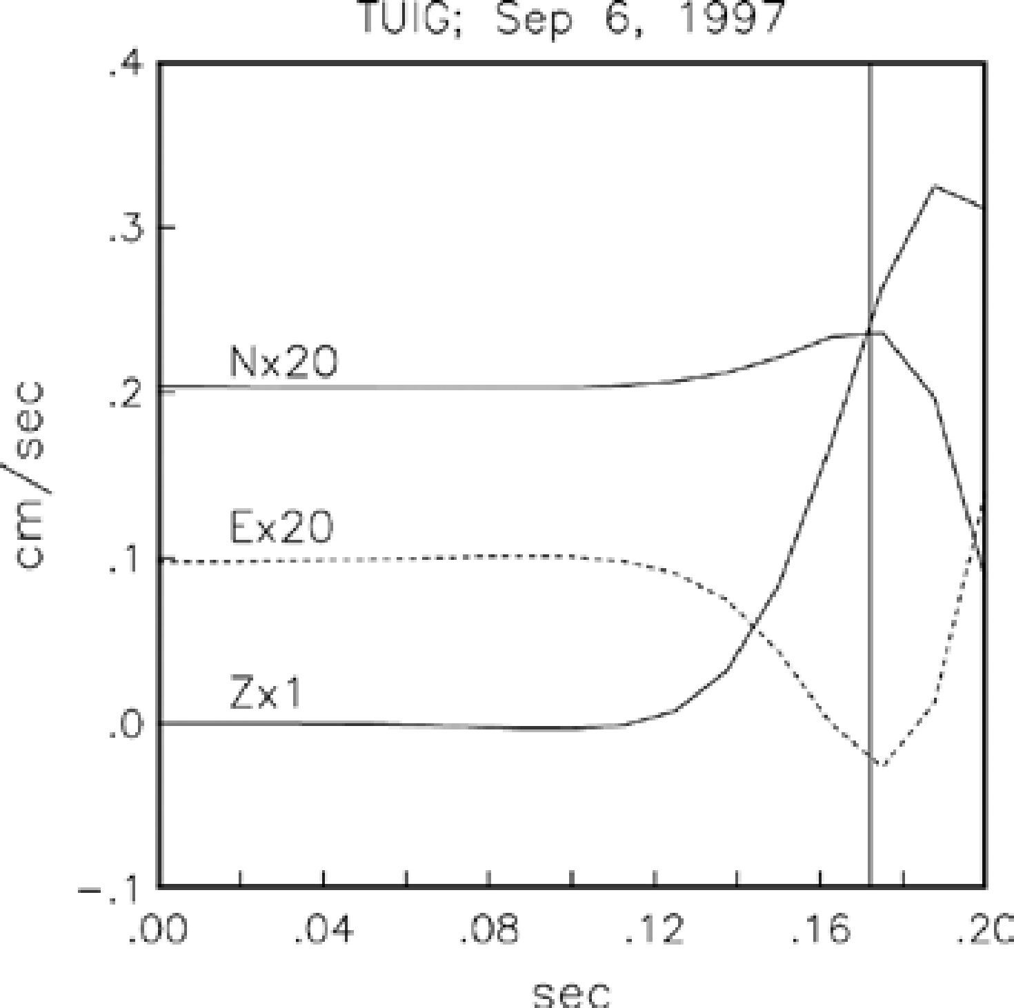
It is known that a single, near-source, three- component, broadband recording can be used to fi a reliable location and origin time, and also the focal mechanism provided that a rough initial guess of the mechanism is available from other data (see, e.g ., Kanamori et al. , 1990; Singh et al. , 1997, 2000a). The calculation of location and origin time requires clear fi arrivals on each of the three components of the ground motion as well as the knowledge of the local crustal structure. Figure 2 shows acceleration, velocity and displacement traces at TUIG during the 6 September 1997 earthquake. Figure 3 illustrates the initial part of the three components of displacement at TUIG. Note that the horizontal components have been multiplied by 20. The fi shows that the incidence of initial P -wave at the station is nearly vertical. Even so, it can be seen that the station is located in the NW quadrant with respect to the source. In Figure 3 the amplitude towards west at time 0.172 is 3.5 times that towards north. It follows that the station azimuth, ϕs , is 286°. Before proceeding further with the analysis of the source parameters of the earthquake, we summarize our knowledge of the local crustal structure.
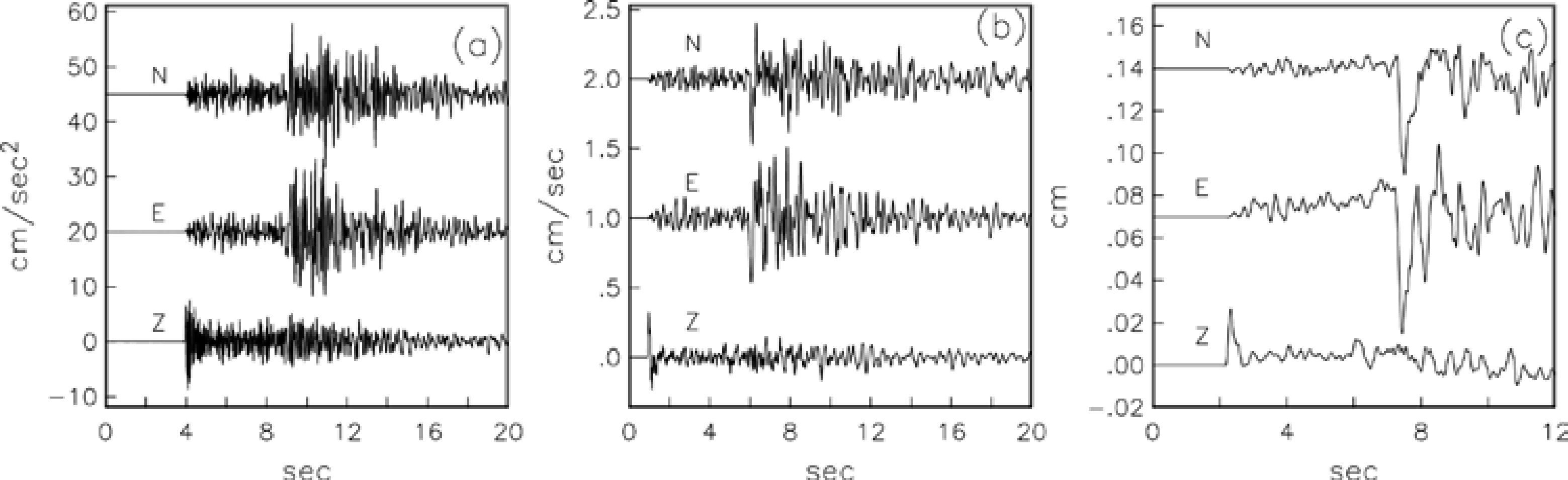
Figure 2 Seismograms at station TUIG during the 6 September 1997 earthquake. (a) Acceleration, (b) velocity, and (c) displacement. The traces in (b) and (c) have been obtained by integration of the accelerograms shown in (a).
Crustal structure of the region
P -wave speed, α , in the shallow crust south and near Coatzacoalcos is available from explorations carried out by PEMEX (A. Camargo, personal communication, 1997). It consist of a 1.8 km thick layer with α = 2.5 km/s, overlying a layer of α = 4.25 km/s. The thickness of the second layer exceeds 3.4 km, the maximum depth reached by boreholes. Based on receiver function analysis, Cruz-Atienza (2000) reports sediment thickness of 16 km below TUIG. N. Shapiro (unpublished report) inverted group velocity dispersion curve corresponding to the region between the City of Oaxaca and TUIG. In the inversion, Shapiro fi ed the thickness of the fi layer and α values of the fi and the second layers to the values given by PEMEX. The shear-wave speeds, β , of the fi and second layers were taken as 1.4 km/s and 2.4 km/s, respectively. The crustal model adopted from the results of Cruz-Atienza (2000) and N. Shapiro, and used by us in generating synthetic seismograms, is given in Table 1. In this table, the densities and the quality factors of the layers have been taken arbitrarily; the results are not very sensitive to their choices.
Source parameters of the earthquake
For the crustal model in Table 1 and (S -P ) time of 5 s at station TUIG, the maximum depth of the earthquake, Hmax, assuming the station to be located directly above the focus, is 30.9 km. We note that if the thickness of the second layer in Table 1 is taken as 10 km, then H max becomes 34.8 km. Near-vertical incidence at TUIG may be a consequence of both small epicentral distance as compared to the source depth, and refraction of waves caused by progressively lower seismic speeds near the surface.
Figure 4, top, shows P -wave first-motion polarities at those Mexican and teleseismic stations where they could be read unequivocally. These data suggest a thrust-faulting earthquake with possible strike-slip component. The first motions provide some constrains on the azimuth (140° ≤ ϕ ≤ 190°) and the dip (45° ≤ δ ≤ 85°) of one of the nodal planes but the rake, λ, of this plane can vary between 35° and 120°. To determine the focal mechanism, we performed waveform inversion of the displacement traces at TUIG. The inversion assumes that the event may be approximated by a point-source shear dislocation. Synthetic seismograms include near and intermediate-field contributions (Singh et al. , 2000a). The effect of free surface is approximately taken into account by multiplying infinite synthetics by two. This approximation is acceptable if the epicentral distance, ▵, is smaller than the depth, H . We took station azimuth,ϕ s , 286°, take-off angle from, the source, i h as 170°, and angle of incidence at, the surface, i o as 5° from the vertical. Based on Stress regime of the Gulf coast region of Coatzacoalcos-Minatitlan observed P -pulse on Z -component (Figure 2c), we chose a triangular source with duration, τ, of 0.38 s. We varied azimuth, dip, and rake in the range mentioned above. No violation of first motion data was allowed. The two nodal planes obtained from the inversion are: ϕ = 150°; δ =70°; λ = 90° and ϕ = 330°; δ = 20°; λ = 90°. The observed and synthetic seismograms are shown in the bottom left of Figure 4.
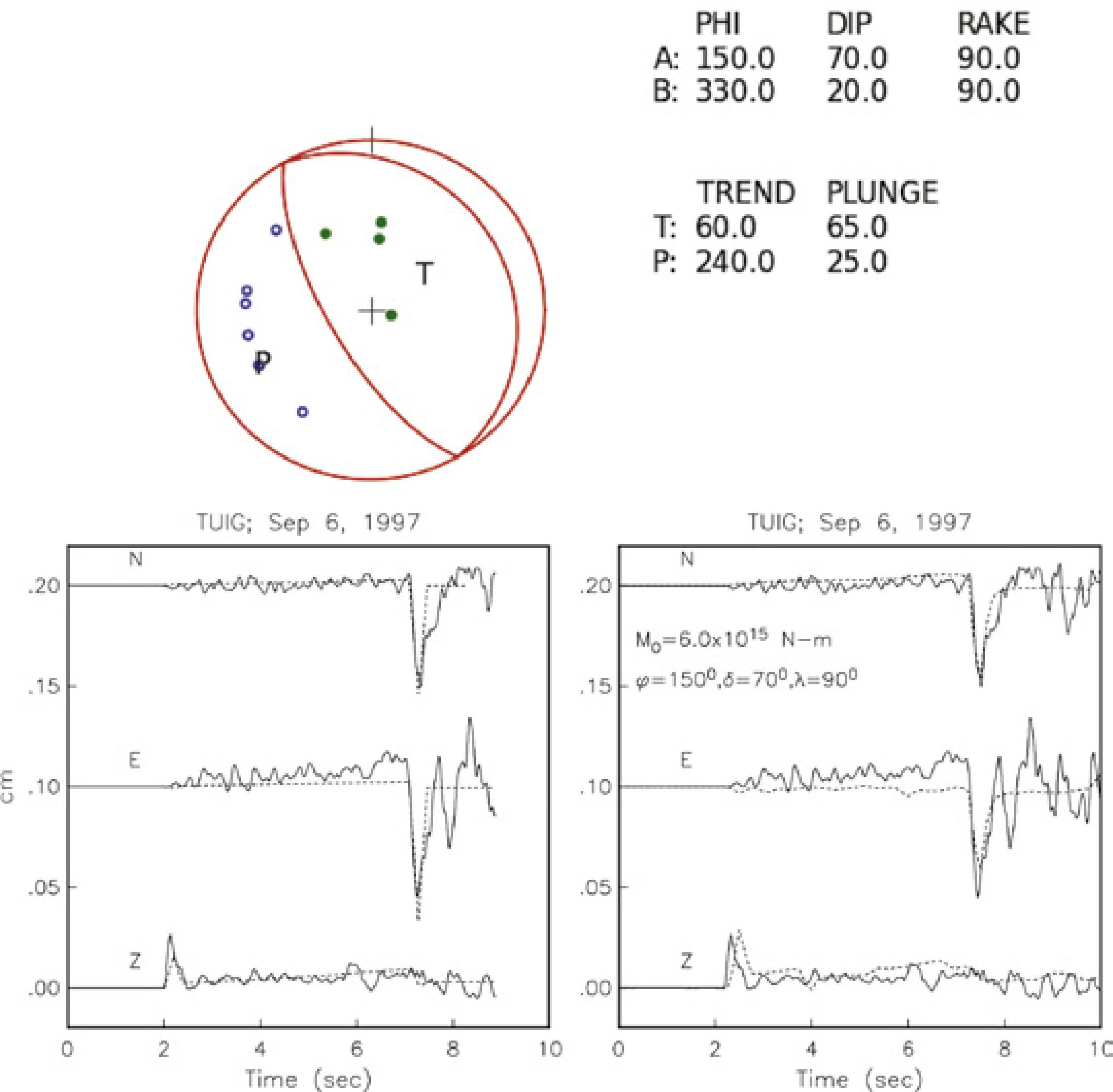
Figure 4 (Top) P-wave first motions of the 1997 earthquake plotted on lower-hemisphere, equal-area projection. With the exception of TUIG, all Mexican broadband stations recorded dilatation (open circles). Three teleseismic stations and TUIG show compression (solid circles). Focal mechanism, ϕ = 150°; δ = 70°; λ = 90°, which satisfies first-motion data, and the waveform at TUIG is shown. (Bottom, left) Comparison of observed and infinite-space synthetic seismograms at station TUIG. (Bottom, right) Comparison of observed and synthetic seismograms at station TUIG. Synthetics were computed using crustal model and focal parameters given in Tables 1 and 2 , respectively.
We generated synthetic seismograms corresponding to this focal mechanism and the crustal model given in Table 1. Bouchon's (1982) discrete wave number algorithm was used in the computation. We again took ϕ s = 286° and τ = 0.38 s. A good fit between observed and synthetic seismograms at TUIG was found for an epicentral distance of 7 km and a depth of 30 km and M 0 = 6.0x10¹⁵N-m (M w 4.5) (Figure 4, bottom right). Table 2 summarizes relevant source parameters of the earthquake.

Stress regime of the Gulf coast region of Coatzacoalcos-Minatitlan
In spite of some uncertainty in its focal mechanism, there is no doubt that the 1997 earthquake was a thrust event with, probably, some strike-slip component. It occurred below the Coatzacoalcos-Minatitlan basin at a depth of about 30 km. As mentioned earlier, the surface and the near-surface information from volcanic alignments, borehole elongations, and unpublished PEMEX seismic sections in the Gulf coast basin region of Coatzacoalcos-Minatitlan suggest active normal-faulting in the upper few kilometers (Suter, 1991). Thus, there is a change of stress regime from extension in the sediments of the upper crust to compression in the mid and lower crust. It was previously noted by Suter (1991) and is supported by the 1997 earthquake. Similar change of stress regime is reported in the central Gulf of Mexico by Frohlich (1982) from an analysis of an earthquake which occurred in 1978 at the edge of the Mississippi Fan at a depth of 15 km (Figure 1). Other cases of stress change below sedimentary basins are discussed in Zoback and Zoback (1991).
Table 2 lists seven intraplate earthquakes located in and near the Gulf of Mexico with known focal mechanisms. It includes the earthquakes of 1978 and 1997. Locations of these events and their focal mechanisms are illustrated in Figure 1. For earthquakes of 2007 and 2009 more than one solution is available (Table 2). For these two earthquakes, the Global CMT location and focal mechanism is shown in the figure As most intraplate regions, the Gulf is characterized by compressive stress regime (Zoback et al ., 1989). Orientations of P -axis of 1959, 1967, 2006, 2007 and 2009 earthquakes range between N30°E and N65°E. These orientations fall between the directions of: (1) the relative convergence of Cocos and North American plates and (2) the absolute motion of North American plate. Perhaps both the relative convergence and the absolute motion are responsible for the observed P -axes, with former playing more dominant role for events in and near SSW Gulf due to their relative proximity to the middle America subduction zone (earthquakes of 1959, 1967, 1997, and 2009) and latter being dominant for events of 2006 and 2007 which are relatively far from the plate boundary. For the 2006 earthquake, sliding of Sigsbee salt and landslide have also been suggested as possible causes (Nettles, 2007).
Dewey and Suárez (1991) and Suárez (2000) suggest that the intraplate, mid- and lower- crust compression below the Coatzacoalcos- Minatitlan basin, as revealed by the 1959 and 1967 earthquakes, may be a consequence of strong coupling along the plate interface where Tehuantepec ridge subducts below Mexico. This may also be true for 1997, and 2009 earthquakes. If so, then, unlike subduction of many other ridges (Kelleher and McCann, 1976), the Tehuantepec ridge does not subducts aseismically. Since there is no clear evidence of major/great earthquakes in the Tehuantepec region in the last two centuries (see, e.g. , Singh et al. , 1981), it could mean that the recurrence period of such events in this segment is much greater than other segments along the Mexican subduction zones where it is ∼ 30 to 75 years (Singh et al. , 1981; Astiz and Kanamori, 1984).
P -axis of 1978 earthquake does not follow the trend of the other events. The compressional nature of the 1978 Mississippi Fan earthquake was interpreted by Frohlich (1982) as a consequence of downwarping of the lithosphere due to accumulation of sediments.
Expected ground motions in the Coatzacoalcos-Minatitlan region from a postulated Mw 6.4 earthquake
The earthquake of 1959 destroyed a majority of the dwellings in the town of Jaltipan (Rosenblueth, 1964). Many buildings suffered structural or foundation failures in Coatzacoalcos and Minatitlan (Marsal, 1961; Reséndiz, 1964). The land near the port of Coatzacoalcos subsided. Some of the effects of the earthquake were attributed to partial liquefaction of sand and silt (Marsal, 1961). Modified Mercalli (MM) intensities in these towns during this earthquake were VIII (Figueroa, 1964). The 1959 earthquake was not an isolated event. The epicenter of the earthquake of January 11, 1946 was apparently close to that of 1959 (Figueroa, 1964). The earthquake of 1946 has been assigned a magnitude of 6.0 (Figueroa, 1970) and MM intensity of VII in Coatzacoalcos (Figueroa, 1964). The towns of Coatzacoalcos and Minatitlan are now important centers of national petroleum activity. Thus, it is of significant earthquake engineering interest to estimate the ground motions in these towns during a future local M w 6.4 earthquake.
To estimate the ground motions from an Mw6.4 earthquake, we used the recording of 1997 earthquake as an empirical Green's function (EGF) and a method proposed by Ordaz et al. (1995) which is based on adding N scaled EGF records, each differed in time by a random delay. The probability distribution of the delays is such that, on an average, the simulations follow an ω2-spectral scaling at all frequencies. The method requires specification of the seismic moment, M0 , and the stress drop, Δσ, of both the EGF and the target earthquake. In our case, M0 of the EGF is 6x10¹⁵ N-m and that of the target event is 5x10¹⁸ N-m (Mw 6.4). A rough estimate of the static stress drop of the EGF can be obtained from the following considerations. For a circular rupture, the radius, a, of the fault can be estimated by (Boatwright, 1980):
 (1)
(1)
where τ1/2 is the rise time of the far-field pulse, ν is the ruptura speed, c is the wave speed, and θ is the take-off angle measured from fault normal. For this event, τ ν2 is about 0.19 s (Table 2, Figure 2c). For S wave, c = β, which we take as 3.75 km/s (Table 1). Assuming Φ = 330º; δ = 20º; λ = 90º as the fault plane and ih =170º, θ is ~10º. For ν = 0.9β, we obtain a fault radius a = 0.76 km (equation 1). For a circular fault, Δσ is related to M0 and a by (Keilis-Borok, 1959):
 (2)
(2)
which gives Δσ of ~ 6 MPa for the EGF. In the simulations, we take Δσ of the EGF and the target event to be either 6 MPa or 12 MPa. Typical simulated acceleration, velocity, and displacement traces, corresponding to Δσ = 6 MPa for both events, are illustrated in Figure 5. In the figure, we compare deterministic, synthetic displacement seismograms with ones obtained by random summation of EGF. The synthetics were generated at TUIG for an event with M0 = 5x10¹⁸ N-m (Mw 6.4), located at the same focus as the 1997 earthquake, and having the same focal mechanism. Duration of source time function, τ, of Mexican earthquakes is related to seismic moment by M0 = (6.7x10¹⁶) τ 3 (Singh et al., 2000b). Thus, the estimated τ for the target event is 4.2 s. A point source with a triangular source-time function of 4.2 s duration and the crustal structure given in Table 1 were taken for the computation. The PGD values are within a factor of two of each other. Both calculations show important near-field contribution (the ramp-like wave between P and S wave).
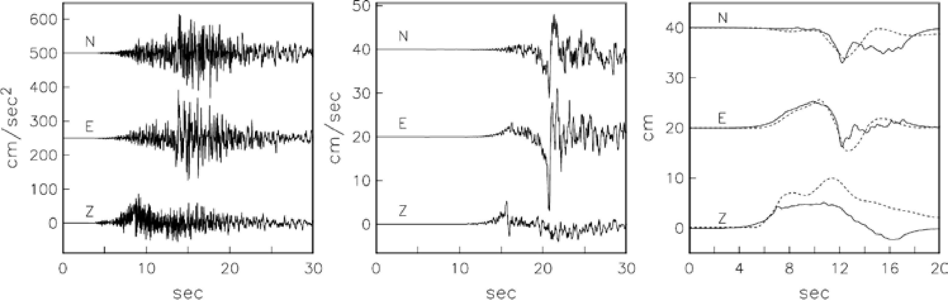
Figure 5 An example of simulated acceleration, velocity, and displacement traces in the epicentral region from a postulated Mw 6.5 earthquake, using recording of the 1997 earthquake as empirical Green's function (stress drop of EGF = stress drop of target earthquake = 6MPa). The right frame also shows, by dashed lines, the deterministic, synthetic displacement seismograms at TUIG for an Mw 6.5 earthquake located at the focus of the 1997 event.
Results of simulation for various combinations of Δσ are summarized in Table 3. The expected horizontal PGA , PGV , and PGD range between 120 and 260 gal, 12 and 28 cm/s, and 6 and 11 cm, respectively.
Table 3 Simulated peak ground motions for a postulated Mw6.4 earthquake using recordings of the 1997 earthquake as EGF.

Although the ground motions estimated by random summation of the EGF are reasonable, there are several factors which introduce uncertainties in these results. The stress drop of the EGF event is uncertain and that of the target earthquake is assumed. The directivity of the source may give rise to greater or smaller ground motions than those computed by our method. Finally, a single EGF may not be adequate to sample the entire fault plane of an M w 6.4.
We emphasize that synthesis of the ground motion is based on the assumption of linear response of the sediments. Almost certainly the shallow sediments of the Gulf basin will behave nonlinearly under such excitation, as was the case during the 1959 earthquake. The results of the simulations, however, provide input motion for the computation of nonlinear response of the subsoil.
Conclusions
Our analysis shows that the 6 September 1997 earthquake (H = 30 km; M w 4.5), like the nearby earthquake of 26 August 1957 (H = 21 km; M w 6.4), was a thrust event. The event reinforces a previous conclusion that while the upper sediments of the Gulf coast basin are in extensional stress regime, the mid and lower crust is under compression (Dewey and Suárez, 1991; Suter, 1991).
Our estimation of ground motion in the epicentral region of Coatzacoalcos-Minatitlan basin due to a postulated M w 6.4 earthquake indicates that peak acceleration, velocity, and displacement (assuming linear behavior of the sediments) may be in the range of 120-260 gal, 12-28 cm/s, and 6-11 cm, respectively. These, then, are also our estimations of the ground motions during the 1959, M w 6.4, earthquake.
These estimations were obtained using 6 September 1997 event as an empirical Green's function under various simplifying, though reasonable, assumptions. Subjected to such ground motions the sediments of the Gulf Coast are likely to behave nonlinearly and may suffer liquefaction, as was the case during the 1959 earthquake.

