


Services on Demand
Journal
Article
 English (pdf)
 Article in xml format
 Article references
 Send this article by e-mail
Indicators
-
 Cited by SciELO
 -
 Access statistics
Related links
-
 Similars in
SciELO
Similars in
SciELO
Share

 Permalink
Geofísica internacional
On-line version ISSN 2954-436XPrint version ISSN 0016-7169
Geofís. Intl vol.51 n.4 Ciudad de México Oct./Dec. 2012
Original paper
Characterization of a leachate contaminated site integrating geophysical and hydrogeological information
Salvador I. Belmonte-Jiménez1*, Martha E. Jiménez-Castañeda2, Marco A. Pérez-Flores3, José O. Campos-Enríquez4, Jaime A. Reyes-López5 and Leobardo Salazar-Peña6
1 Centro Interdisciplinario de Investigación para el Desarrollo Integral Regional (CIIDIR–Oaxaca). Instituto Politécnico Nacional, Hornos 1003, Colonia Noche Buena Sta. Cruz Xoxocotlán C.P. 71230 Oaxaca, México. *Corresponding author: sbelmont@prodigy.net.mx.
2 Posgrado en Aprovechamiento y Conservación de Recursos Naturales. Centro Interdisciplinario de Investigación para el Desarrollo Integral Regional (CIIDIR–Oaxaca). Instituto Politécnico Nacional Oaxaca, México.
3 Centro de Investigación Científica y de Educación Superior de Ensenada, Baja California, México. E–mail: mperez@cicese.mx.
4 Departamento de Geomagnetismo y Exploración Instituto de Geofísica, Universidad Nacional Autónoma de México México D.F. E–mail: ocampos@geofisica.unam.mx.
5 Instituto de Ingeniería. Universidad Autónoma de Baja California, Mexicali.
6 Escuela Superior de Ingeniería y Arquitectura, Unidad Ticomán, Instituto Politécnico Nacional.
Received: September 30, 2010;
accepted: April 18, 2012;
published on line: September 28, 2012.
Resumen
Se reporta en este estudio la caracterización de una zona contaminada por lixiviados, siguiendo una metodología que integra datos geofísicos y geohidrológicos para proponer un modelo hidrogeológico del fenómeno. La caracterización del sitio (la estructura del subsuelo, y las características del suelo) incluyó seis perfiles sísmicos de refracción, tres líneas electromagnéticas (FDEM), dos perfiles eléctricos (ERT), cinco sondeos eléctricos verticales (SEV), y una serie de pruebas geohidrológicas para delimitar la pluma contaminante. El área de estudio corresponde a la laguna de lixiviados del relleno sanitario de la ciudad de Oaxaca, sur de México. El modelo hidrogeológico que se presenta constituye un ejemplo del potencial de la integración de varios métodos aplicados con el mismo objetivo; reduciendo así la ambigüedad de la respuesta geofísica. Los resultados indican que los valores de baja resistividad (1.5 a 2.5 Ohm-m) se relacionan con un suelo contaminado subyaciendo a la laguna de lixiviados y al medio fracturado. También se detectó un desplazamiento de la pluma contaminante hacia el SW de la laguna. La calidad del agua es buena, pero la actividad humana en el área de estudio confiere un riesgo para el acuífero superficial de Zaachila.
Palabras clave: lixiviados, prospección geofísica, caracterización hidrogeológica.
Abstract
In this study we report the characterization of a leachate contaminated site, by following a methodology that integrates geophysical and geohydrological data to better constrain a hydrogeological model. The characterization of the site (subsurface structure, soil characteristics) included six seismic refraction profiles, three electromagnetic lines using transient domain electromagnetic soundings (TDEM), two electric resistivity tomography (ERT) profiles, five vertical electrical sounding (VES) and geohydrological testings and analysis to support the delimitation of the contaminant plume. The study area corresponds to the leachate lagoon of Oaxaca City landfill, southern Mexico. Its inferred hydrogeological model constitutes an example of the uselfuness of the integration of several diverse methods applied with the same objective, thus reducing the ambiguity of applying a single characterization technique. The results indicate that low resistivity values from 1.5 to 2.5 Ohm-m are related to a leachate polluted soil underlying the leachate lagoon and also associated with an anomaly enclosed in the rockbed. A displacement of the polluted plume to the SW from the lagoon was also detected. Water quality is quite good but the human activity in the study area confers a risk to the Zaachila aquifer.
Key words: Leachate, geophysical surveys, hydrogeological characterization.
Introduction
Landfill leachates constitute a potential form of water pollution. Their effect on the environment has been documented in several studies (Williams et al., 2000; Sun et al., 2001; Porsania et al., 2004; Feng et al., 2007). However there exist many geologically inadequate landfills which increase the vulnerability of the surrounding sites (Bengtsson et al., 1994).
The assessment of soil and water properties is important to characterise leachate impact (Nobes, 1996; Fatta et al., 1999; Rosqvist et al., 2003; Kumar and Alappat, 2005). Drilling is a direct method to obtain data but is punctual and expensive. On contrary, geophysical methods cover larger areas and are relatively inexpensive. Electrical and electromagnetic methods are frequently used in groundwater applications (Atekwana et al., 2000; Buselli and Lu, 2001; Yoon and Park, 2001; Inman et al., 2002; Rosqvist et al., 2003; De la Vega et al., 2003; Chandra et al., 2004; Corwin and Lesch, 2005 a, b; Owen et al., 2005; Bauer et al., 2006; Asfahani, 2007). However, better results of geophysical methods are obtained by applying jointly methods which are supplementary with respect to their sensitivity to the physical properties of interest.
In this study we have integrated three geophysical methods (seismic refraction, electromagnetic induction and electric resistivity) with hydrological parameters to obtain a robust model of the leachate lagoon of Oaxaca City landfill.
Our objective is to characterise this site since recently has been populated and inhabitants have drilled wells with the risk represented by not knwowing the water quality.
Materials and methods
Study site
The Oaxaca city Landfill, located at Zaachila receives 550 ton/day of waste (Figure 1). As result of waste weatering, a leachate stream have been flown down to a leachate lagoon for more than 25 years. The so called "leachate lagoon" is a structure constructed 1.8 km from the landfill as a oxidating pound, but with the opening of the landfill the flowing water have transported toxic substances that made of the pound a highly polluted site.
The area surrounding the leachate lagoon is composed by granular alluvial material and fractured sedimentary rocks such as sandstone and shale, that enable leachate infiltration to the subsoil (Belmonte et al., 2005). Another important feature to consider is the presence of the Oaxaca Fault (N10W) in the Zaachila Valley (Nieto-Samaniego et al., 1995; Campos-Enríquez et al., 2010).
Seismic refraction survey
The seismic refraction survey at the leachate lagoon was designed to study the contrast between the unsaturated zone and the rockbed. Six seismic refraction lines with lengths of 108 m were obtained at several places around the site (Figure 2). A geophone spacing of 6 m and a hammer of 6 kg was used as the seismic source. Data was collected using a 24-channel seismograph (McSeis 170 OYO) and were interpreted using Geogiga software (2009).
Electromagnetic survey
Electromagnetic profiling along three 500 m long profiles with stations every 5 m were obtained using the Geonics EM34 conductivity meter operating at frequencies of 400, 1,600 and 6,400 Hz with a coil separation of 40, 20 and 10 m respectively. Further explanation of the theory used in EM34 can be reviewed in McNeill (1980). For each coil separation the data were acquired with the coils oriented both horizontally and vertically in relation to the surface. The data interpretation was performed using the CICEM35 software developed at CICESE (Centro de Investigación Científica y de Educación Superior de Ensenada, Mexico), based in the modification of Gómez-Treviño's theory (1987) adapted by Pérez-Flores et al. (2001) for shallow EM.
D. C. Electric resistivity survey
a) Profling
Two D.C. electric resistivity profiles using the dipole-dipole array were performed in the study area. DIP1 was conducted in the NW border of them leachate lagoon with a 100 m length, 7 levels of investigation and an inter-electrodic distance, a, of 2 m. DIP2 was located in the southwestern border with a 250 m length, an interelectrodic distance of 5 m, and 7 levels of investigation. The data were interpreted using the CICRES35 software from CICESE (Pérez-Flores et al., 2001).
Misfit were 6.3 and 7.2% for DIP1 and DIP2 respectively. The 2D models were obtained in a single iteration under the approximation of low-resistivity contrast as explained in Pérez-Flores et al. (2001).
b) Sounding
In the dry season of 2008 (May) five vertical electrical soundings (VES) using the Schlumberger configuration were obtained in the study site (Figure 2). SEV1, SEV2 and SEV3 were made inside the lagoon, while SEV4 and SEV5 were located at the western and eastern borders respectively. A maximum current electrode spacing (AB/2) of 100 m was used for all the soundings. The processing and interpretation of the respective geoelectrical data was performed using the DCINV software (Pirttijärvi, 2005). During this survey particular attention was given to the electrode length since the soil texture did not allow the penetration of the electric current and it became necessary to use 60-cm long electrodes.
Hydrologeological control parameters
A piezometric map of the leachate lagoon was made by monitoring 8 wells drilled by the inhabitants as their source of potable water (Figure 3). Such monitoring wells were geo-referenced using an Astech ProMark2 GPS System and were also used to establish electric conductivity, total dissolved solids (TDS) and pH of water using a Hanna HI 98129 tester. The underground flow pattern was determined during the dry seasonof 2007(November) and during the wet season (July, 2008). The hydraulic conductivity was established with two tests (D1 and D2) carried out in July of 2008 (Figure 3) using a variable charge infiltrometer. The dataset obtained was analyzed using the Darcy's method (Sumner, 2000).
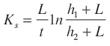
Where
h1 + L is the hydraulic head in the upper part of the infiltrometer.
h2 + L is the hydraulic head in the lower part of the infiltrometer.
Once the hydraulic conductivity was established, the transmisivity was estimated using stratum thicknesses obtained by means of the seismic study. Porosity was established through the Kozeny-Carman equation (Batu, 1998) modified for the conditions of the study area.
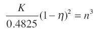
Where
K is the hydraulic conductivity.
n is the porosity.
Metal content and some chemical parameters (DOQ, carbonates, pH, electrical conductivity) were analyzed in samples of leachate and water from the closest well to the lagoon, P4 (Figure 3).
Results
Geophysical Surveys
a) Refraction seismic
Figure 4 shows the travel-time curves (hodooch-rones) corresponding to the SIS1 and SiS2 seismic profiles.
According to the seismic refraction data (Figure 5) to the west of the lagoon, along profiles SIS2, SIS1 and SIS3, there is a shallow layer with a velocity of 390 m/s associated to alluvium, overlying a shale bed with a velocity of 2,800 m/s. On the other side of the lagoon, along SIS5, SIS4 and SIS6 profiles (Figure 6), it was possible to delineate three layers. Below SIS5 and SIS6, the shallower bed presents a velocity of 390 m/s associated also to alluvium, while below SIS4 it presents a velocity of 280 m/s related to polluted alluvium close to the leachate lagoon. This first layer reaches its maximum depth of 7 m in SIS4 and SIS6. Along profiles SIS5 and SIS6, below the alluvium bed, there is a layer with a velocity of 1,300 m/s that has been interpreted as fractured shale. Contrastingly, in profile SIS6, the shale is not fractured and has a velocity of 2,800 m/s. Finally at the base of these three profiles a stratum with velocity of 3,700 m/s was mapped, which is been interpreted as the upper portion of an anticlinal structure of sandstone probably related to the Oaxaca Fault System.
b) Electromagnetics
Electromagnetic sections (Figure 7) indicate three resistivity domains. The shallowest one has a resistivity ranging from 10 to 30 Ohm-m associated with alluvium and clay. The second domain is related to resistivites higher than 70 Ohm-m representing shale and fractured shale according to the seismic models (Figures 5 and 6). The last domain corresponds to a very conductive anomaly with values less than 10 Ohm-m associated with the leachate. In the EM1 profile, the conductive anomaly is seen at the surface from the positions -200 to -100 m. Although the resistivity would suggest the presence of polluted soil, the true correspondence with the contaminants is found from 0 to 100 m due to the presence of the leachate channel. However, anomalies at depths of more than 20 m centred at positions -100, 0 and 150 m could suggest a toxic plume in the subsoil. The EM2 profile indicates the presence of a 2-D electric resistivity distribution mainly from -50 to 50 m coinciding with the lagoon. The DIP1 and SIS1 profiles also cover this area and indicate a conductive anomaly and a stratum of alluvium, respectively. Other important sections with low resistivity (less than 5 Ohm-m) are shown at positions -150 and 250 m, assumed as the signature of a contaminant plume percolating into the subsurface from the SW border of the lagoon and the area around the channel. From -100 to 100 m the EM3 model has a conductive anomaly (10 Ohm-m) associated with an area of leachate inundation during the rainy season, and the anomaly is represented in the DIP2 model (Figure 8). From -250 to -200 m, underlying a section with a resistivity higher than 100 Ohm-m, the model presents a value less than 5 Ohm-m interpreted as a leachate infiltration at a 30 m depth. According to the 2-D distribution of the EM models, changes going from the surface to the bottom of the sections, are interpreted as due to vertical fractures.
c) D.C. Electric resistivity
The dipolar profiles (Figure 8) DIP1 located at the western limit of the lagoon corresponds to the SIS1 seismic profile and to the central portion of the EM2 electromagnetic profile (Figure 7). DIP1 is featured by low resistivity values between 5 to 30 Ohm-m coinciding to the very conductive area (<10 Ohm-m) related to the subsoil around the leachate channel as depicted by the EM2 electromagnetic image between positions -50 and 50 m. The opposite profile, DIP2, covers SIS4 and SIS5 profiles and the right side of the EM3 profile from -150 to 100. DIP2 shows a very conductive section with values less than 20 Ohm-m in correspondence to a zone of leachate inundation that can also be observed in the EM3 electromagnetic image between distances -100 and 50 m (Figure 7). In both DIP1 and DIP2 models resistive anomalies of 100 Ohm-m are associated with fractured shale.
Figure 9 shows, for comparison purposes, VES curves obtained from soundings inside the leach-ate lagoon and outside it respectively.
Hydrologeological control parameters
The SW-D1 test (Figure 3) gave a hydraulic conductivity (K) of 64 m/day. The correspon-ding transmisivity (T) has a value of 282m2/day and a porosity of 35%. At the NW-D2 test, the hydraulic conductivity (K) was of 157 m/day, a transmisivity (T) of 1,413m2/day, and a porosity of 39%. Figure 10 shows the preferential underground flow pattern in the wet (November/2007) and dry seasons (July, 2008) when there was a depression due to water extraction. Electric conductivity of water (Figure 11a) ranged from 543 to 752µS/cm, except in the P1 well, with an electric conductivity of 2,148µS/cm. We infer that this last value shows the effects influence of polluted plume at P3 and P4 wells. The water table is located in the shale layer; it decreased 3 m during the dry season (July/2008) with respect to the wet season. In contrast, the water table in the P1 well was constant in both seasons; this constancy together with the low transmisivity (282m2/day) of the zone favours the existence of the polluted plume. In addition, the analysis of the water from P4 well indicates an important presence of chlorides (26.42 mg/l as Cl-) and nitrates (0.5 mg/L as N-NO3). Figure 11b indicates the water pH in the study zone. The image shows that groundwater is almost neutral (7.12), but the monitoring of the wells close to the leachate lagoon shows that the water pH is slightly more basic (7.38). Physicochemical analysis of leachate sample indicated a pH of 8.4, which is related to an old fluid; the leachate COD (Chemical Oxygen Demand) was established in 27,887.8 mg COD/l and its electric conductivity was 46,000µS/ cm. Metal content in water, soil and leachates is summarized in Table 1. Here is observed that there are some elements in the leachate and soil that do not exist in water. Two explanations are possible. Either this circumstance indicates the infiltration to the rockbed through the fractures of the study area or the alluvium in the fractures allows the retention of some pollutants.
The hydrogeological model
The hydrogeological model of the leachate lagoon integrates the geophysical based information and the geohydrological control parameters (Figure 12). This model presents a very contaminated and conductive soil (1.5 to 2.5 Ohm-m) with a low velocity of 280 m/s immediately underlying the leachate lagoon and the leachate channel. This soil is associated to alluvium that is featured by resistivity values from 25 to 27 Ohm-m and a velocity of 390 m/s. The alluvium is relatively shallow with a maximum depth of 10 m at the NE border of the lagoon. The lower layer is highly fractured shale, probably related to the Oaxaca Fault, with a resistivity value of 40 to 60 Ohm-m and a velocity of 1,300 m/s through which leachates could be infiltrating to the bedrock. In contrast, outcropping of shale presents the same resistivity range but a velocity of 2,700 m/s. Between alluvium and shale layers the water table fluctuates depending on the season (Figure 13). Small fractures could allow diffusion of pollutants in the aquifer but probably the characteristics of the soil have delayed them reaching the water (see Table 1). Finally the bedrock is represented by a shale-sandstone sequence with a velocity of 3,700 m/s. Here the polluted soil is related to a very conductive anomaly (<10 Ohm-m) at a depth of 30 m coinciding with the lagoon and leachate channel.
Conclusions
The geophysical information of the structure of the subsurface and geohydrological parameters allows more robust characterization of contaminated sites. This methodology is useful to establish a representative robust hydrogeological model of a study area and could be applied in detection and remediation of leachate contaminated sites. In the current case, the results indicate a very contaminated area underlying the lagoon and an important conductive area enclosed in the rock bed at a depth of 30 m. Both anomalies indicate leachates in the subsoil. Moreover a displacement of a polluted plume to the SW of the lagoon was detected. With respect to water quality, the results do not show the presence of toxic substances, although urbanization of the study site disturbs soil dynamics, and water extraction and house building are increasing the vulnerability of the Zaachila aquifer to the pollution.
Acknowledgments
This study was made with support of the projects SIP:20060280, and SIP:20070076 of CIIDIR-IPN.
References
Asfahani J., 2007, Geoelectrical investigation for characterizing the hydrogeological conditions in semi-arid region in Khanasser valley, Syria. J. of Arid Environments, 68, 31-52. [ Links ]
Atekwana B., Sauck W., Werkem D., 2000, Investigations of geoelectrical signatures at a hydrocarbon contaminated site. Journal of Applied Geophysics, 44. 167-180. [ Links ]
Batu V., 1998, Aquifer Hydraulics. A Comprehensive Guide to Hydrogeologic Data Analysis. John Wiley and Sons, Inc. New York, NY. 752 p. [ Links ]
Bauer P., Supper R., Zimmermann S., Kinzelbach W., 2006, Geoelectrical imaging of groundwater salinization in the Okavango Delta, Botswana. Journal of Applied Geophysics, 60, 126-141. [ Links ]
Belmonte-Jiménez S., Campos-Enríquez J., Alatorre-Zamora M., 2005, Vulnerability to contamination of the Zaachila aquifer, Oaxaca, México. Geofísica Internacional, 44 , 283-300. [ Links ]
Bengtsson L., Bendz D., Hogland W., Rosqvist H., Aksson M., 1994, Water balance for landfills of different age. Journal of Hydrology 158 pp. 203 - 217. [ Links ]
Buselli G., Lu K., 2001, Groundwater contamination monitoring with multichannel electrical and electromagnetic methods. Journal of Applied Geophysics, 48, 11 - 23. [ Links ]
Campos-Enríquez J.O., Belmonte-Jiménez S.I., Koppie J.D., Ortega-Guerrero F., Arzate J.A., Martínez -Silva J., Martínez-Serrano R.G., 2010, Gravity and magnetic survay of the Oaxaca city region: Cenozoic horst and graben structure superimposed on the Oaxaca-Juárez terrane boundary, southern Mexico, Journal of South American Earth Sciences, 29, 572-585. [ Links ]
Chandra S., Anand Rao V., Singh V., 2004, A combined approach of Schlumberger and axial pole-dipole configurations for groundwater exploration in hard-rock areas. Current Science, 86, 1,437-1,442. [ Links ]
CICEM35, Pérez-Flores M., Goméz-Treviño E., 2D Resistivity and EM Inversion. EM-34 2D inversion program. Internet free use: http://arcada.cicese.mx/geofisica/dc2/index.html [ Links ]
CICRES35, Pérez-Flores M., Goméz-Treviño E., 2D Resistivity and EM Inversion. DC resistivity. 2D inversion program. Internet free use: http://arcada.cicese.mx/geofisica/dc2/index.html [ Links ]
Corwin D., Lesch S., 2005a, Characterizing soil spatial variability with apparent soil electrical conductivity. Part I. Survey protocols. Computers and Electronics in Agriculture, 46, 103-133. [ Links ]
Corwin D., Lesch S., 2005b, Characterizing soil spatial variability with apparent soil electrical conductivity. Part II. Case study. Computers and Electronics in Agriculture, 46, 135-152. [ Links ]
De la Vega M., Osella A., Lascano E., 2003, Joint inversion of Wenner and dipole-dipole data to study a gasoline-contaminated soil. Journal of Applied Geophysics, 54, 97-109. [ Links ]
Fatta D., Papadopoulos A., Loizidou M., 1999, A study on the landfill leachate and its impact on the groundwater quality of the greater area. Environmental Geochemistry and Health, 21, 2, 175-190. [ Links ]
Feng S., Wang X., Wei G., Peng P., Yang Y., Cao Z., 2007, Leachates of municipal solid waste incineration bottom ash from Macao: Heavy metal concentrations and genotoxicity Chemosphere 67, 6, pp. 1133-1137 DOI:10.1016/j.chemosphere.2006.11.030.88 [ Links ]
Geogiga Software, 2009, Complete Package for Near Surface Geophysics. Geogiga Technology Corp. Canada. [ Links ]
Gómez-Treviño E., 1987, Nonlinear integral equations for electromagnetic inverse problems. Geophysics, 52, 1,297-1,302. [ Links ]
Higuera-Díaz C., Carpenter P., Thompson M., 2007, Identification of buried sinkholes using refraction tomography at Ft. Campbell Army Airfield, Kentucky. Environmental Geology, 53, 805-812, DOI 10.1007/s00254-007-0693-y. [ Links ]
Inman D., Freeland R., Ammons J., Yoder R., 2002, Soil Investigations using Electromagnetic Induction and ground-penetrating radar in southwest Tennessee. Soil Science Society of America Journal, 66, 206-211. [ Links ]
Kumar D., Alappat B., 2005, Evaluating leachate contamination potential of landfill sites using leachate pollution index. Clean Technologies and Environmental Policy, 7, 90-197. [ Links ]
McNeill J.D., 1980, Electromagnetic terrain conductivity measurement at low induction numbers. Geonics Limited, 15 p. [ Links ]
Nieto-Samaniego A., Alaniz-Álvarez S., Ortega-Gutiérrez F., 1995, Estructura interna de la falla de Oaxaca (México) e influencia de las anisotropías litológicas durante su actividad cenozoica. Revista Mexicana de Ciencias Geológicas, 7, 1, 1-8. [ Links ]
Nobes D., 1996, Troubled Waters: Environmental Applications of Electrical and Electromagnetic Methods. Surveys in Geophysics, 17, 393-454. [ Links ]
Owen R., Gwavava O., Gwaze P., 2005, Multi-electrode resistivity survey for groundwater exploration in the Harare greenstone belt, Zimbabwe. Hydrogeology Journal, 14, 244-252. [ Links ]
Pérez-Flores M.A., Méndez-Delgado S., Gómez-Treviño E., 2001, Imaging low-frequency and DC electromagnetic fields using a simple linear approximation. Geophysics, 66, 1,067-1,081. [ Links ]
Pirttijärvi M., 2005, DCINV 1-D Interpretation of electrical (DC) soundings ver 1.4 Finlandia. [ Links ]
Porsania J., Filho W., Elisa V., Shimelesa F., Dou-radob J., Mourab H., 2004, The use of GPR and VES in delineating a contamination plume in a landfill site: a case study in SE Brazil. Journal of Applied Geophysics, 55, 199-209. [ Links ]
Rogenhagen J., Jokat W., Hinz K., Kristoffersen Y., 2004, Improved seismic stratigraphy of the Mesozoic Weddell Sea. Marine Geophysical Researches, 25, 265-282 DOI 10.1007/ s11001-005-1335-Y. [ Links ]
Rosqvist H., Dahlin T., Fourie A., Röhrs L., Bengt-son A., Larsson M., 2003, Mapping of leachate plumes at two landfills sites in South Africa using geolectrical imaging techniques. Proceedings of 9th. International Waste Management and Landfill Symposium. [ Links ]
Sundararajan N., Srinivas Y., Narasimha Chary M., Nandakumar G., Hanmantha C., 2004, Delineation of structures favorable to ground-water occurrence employing seismic refraction method: A case study from Tiruvuru, Krishna district, Andhra Pradesh A. The Proceedings of the Indian Academy of Sciences: Earth and Planetary Sciences, 113, 3, 259 267. [ Links ]
Sumner M., 2000, Handbook of Soil Science CRC Press., USA, 2148 p. [ Links ]
Telford W., Geldart L., Sheriff R., 1990, Applied Geophysics. Cambridge University Press, USA, 796 pp. [ Links ]
Valenta J., Dohnal J., 2007, 3D seismic travel time surveying a comparison of the time-term method and tomography (an example from an archaeological site) Journal of Applied Geophysics, 63, 46-58. [ Links ]
Williams C., Agassi M., Letey J., Farmer W., Nelson S., Ben-Hur M., 2000, Facilitated Transport of Napropamide by Dissolved Organic Matter Through Soil Columns. Soil Science Society of America Journal, 64, 590-594. [ Links ]
Yan Z., Clayton R., Saleeby J., 2005, Seismic evidence for step faults cutting highly attenuated continental basement in the central Transverse ranges, California. Geophysical Journal International, 160, 651-666, DOI:10.1111/j.1365-246X.2005.02506.x. [ Links ]
Yoon G., Park J., 2001, Sensitivity of leachate and fine contents on electrical resistivity variations of sandy soils. Journal of Hazardous Materials, B84, 147-161. [ Links ]

