


Services on Demand
Journal
Article
 English (pdf)
 Article in xml format
 Article references
 Send this article by e-mail
Indicators
-
 Cited by SciELO
 -
 Access statistics
Related links
-
 Similars in
SciELO
Similars in
SciELO
Share

 Permalink
Geofísica internacional
On-line version ISSN 2954-436XPrint version ISSN 0016-7169
Geofís. Intl vol.51 n.2 Ciudad de México Apr./Jun. 2012
Original paper
Microtremor measurements to identify zones of potential fissuring in the basin of Mexico
Efraín Ovando–Shelley*, Javier Lermo–Samaniego, Gabriel Auvinet and Edgar Méndez–Sánchez
Instituto de Ingeniería, Universidad Nacional Autónoma de México, Ciudad Universitaria, Delegación Coyoacán, 04510, México D.F., México. *Corresponding author: eovs@pumas.ii.unam.mx
Received: Frebuary 2, 2011.
Accepted: October 25, 2011.
Published on line: March 30, 2011.
Resumen
El potencial para la aparición de grietas y fisuras en la Cuenca de México puede inferirse a partir de la medición de microtremores. Una gran parte de las grietas de la cuenca han aparecido en zonas donde el espesor de los suelos blandos compresibles cambia bruscamente. Se sabe que el periodo dominante de sitio depende del espesor del suelo compresible, H, a través de la relación elástica T0=4H/Vs, en donde Vs es la velocidad media de ondas de corte. Si se supone que Vs es aproximadamente constante dentro de un área dada, el gradiente del periodo T0 reflejará el gradiente del espesor. Así, si se mide T0 será posible relacionarlo con el potencial de agrietamiento en la cuenca. La técnica de Nakamura provee una manera simple, rápida y económica de estimar T0, al menos en la zona del lago. En este trabajo se valida esta premisa a partir de lo observado en San Lorenzo Ixtapalapa donde se han registrado agrietamientos y en donde también se ha podido estimar H a partir de información geotécnica.
Palabras clave: fisuras y grietas en suelos, hundimiento regional, mediciones de ruido ambiental, Cuenca de México.
Abstract
The potential for the apparition of fissures and cracks in the Basin of Mexico can be inferred from microtremor measurements. Most of the cracking in the basin occurs where there is a sharp gradient in the depth of the hard layer below the soft clay. It is well known that the depth of the hard layer is related to the dominant period, T0, of the site by the relation T0=4H/ Vs, where H is the depth and Vs is the average shear–wave velocity in the clay. If Vs is assumed roughly constant then the gradient of T0 would reflect the gradient in depth. Thus, if we can measure T0 then we can relate it to the potential of cracking in the basin. Nakamura's technique provides a simple, fast, and inexpensive way to estimate T0, at least in the lake–bed zone. The manuscript validates this premise in San Lorenzo, Ixtapalapa, where cracking has been observed and estimation of H is available from geotechnical data.
Key words: fissures and cracks in soils, regional subsidence, ambient vibration measurements, Basin of Mexico.
Introduction
The largest part of Mexico City is located in what used to be a series of interconnected lakes within the Basin of Mexico. Lake bed materials found comprise a succession of extremely soft soils, Mexico City clays, which are the product of the hydration and degradation of volcanic effusions, i.e., clastic materials transported from upper parts of the basin by water currents or glaciers and directly from the volcanoes, by eolic action. These soils are geologically very young and are notorious for their extremely high water content and compressibility. Layers of coarser materials such as ashes and pumices, are also present, the product of volcanic eruptions that occurred during the Upper Pleistocene, as well as various forms of organic matter and microfossils.
The lakes in the Basin of Mexico were desiccated gradually, starting in the 16th century and nowadays the lacustrine system is practically nonexistent. As the city grew, new and ever more distant sources of water had to be sought, so that the possibility of getting water from wells drilled locally became a very attractive option. Initially artesian water was drawn from relatively shallow wells; water was later pumped from deeper wells as demand increased in the second half of the 19th century when it was also recognized that the city was sinking although the reasons for that subsidence were still not known.
Having Terzaghi's Consolidation Theory as a basis, the relationship between population growth, amount of water extracted from the aquifer and subsidence rates was established by the pioneering work of Carrillo (1948), later continued by Marsal and Mazari (1959). Data collected by Tamez (1992) show that from 1900 to 1920 the settlement rate in downtown Mexico City was 3 cm/year; by the 1940's the rate was 13 cm/year and in the early 50's it reached 26 cm per year. Wells in downtown Mexico City were banned and settlement rates decreased to 5 cm/ year. In the late 70's and early 80's new wells were put in operation in the outskirts, mainly near the hills that surround the city in the north and in the south. Settlement rates increased again and, in central Mexico City, they now amount 7 to 10 cm/year but at some sites they exceed 30 cm/year; there are zones in the outskirts, towards the edges of the former lake bed where the ground settles 40cm/year (Mazari, 1996; Auvinet, 2009). The total subsidence over the last 100 years with respect to a reference point outside the lake zone now exceeds 10 m in the downtown area of Mexico City and has reached 13.5m in at least two locations within the basin (Auvinet, 2009). Subsidence and its effects could at least be mitigated if pumping of water were to be reduced or even banned completely from the city but this is hardly possible since around 70% of the water distributed in the Basin of Mexico is obtained from deep wells, a situation which cannot be reverted in the near future given the present urban and demographical trends.
Regional subsidence has had numerous detrimental effects; one of them is the apparition of fissures and cracks in the periphery of the former lakebed (Figure 1) where the thickness of compressible clay strata changes abruptly over relatively short distances. This phenomenon has produced damage to private property and urban infrastructure and has also produced a sense of insecurity in the population. Large cracks which may have other origins have also appeared away from the periphery. In any case, cracking in the lacustrine clays of Basin of Mexico is now recognized as a public hazard that must be assessed and evaluated scientifically.
In what follows we review the mechanisms that produce cracks in soft soils and, specifically, those which affect Mexico City and its environs. We also put forth a method based on the analysis of ambient vibration records for identifying zones that may be prone to be affected by cracking. We discuss the advantages and limitations of this method through the presentation of a case history in which field data from geotechnical was available and where ambient vibration measurements were made.
Cracking mechanisms in the Basin of Mexico
Cracking will appear in soils whenever and wherever there exists a condition which gives rise to sufficiently large tension stresses or extension strains. Fissures and cracks in clay masses can also appear along potential and actual failure surfaces where shear stresses concentrate, for example in slopes, behind retaining walls or under footings or other foundation elements. The most common mechanisms giving rise to tension stresses and to cracks in the Basin of Mexico have been reviewed previously (Auvinet, 2008) but those associated to land subsidence are presently the most troublesome. They are due to the consolidation of the clays due to deep pumping in the valley giving rise to differential settlements that in turn induce tensions and, hence, cracks (Figure 2). They appear mostly in the transition zones and may also be originated by the presence of buried geologic structures:
Sharp Transition Zone cracks. Cracking and fissuring can frequently turn up in abrupt transition zones located in edges of the former lake system where the thickness of compressible clay layers interspersed with silty sands changes sharply over short distances. The presence of a rigid hard crust in the surface enhances the apparition of cracks.
Cracking induced by buried geologic structures. Buried geologic structures like volcanic lava flows, younger clay deposits and alluvial fans are also commonly found along the edges of the former lakes. Many of these, especially geological buried structures such as a hortz or a graben may also present a geometrical condition that favours alignment of cracks. These cracks should not be associated to displacements along geological faults, since it has been previously established that the dominant factor in the Basin of Mexico is the compression of the soft soil strata (Méndez et al., 2008).
Cracking due to stratigraphical heterogeneities. Variations in soil properties, mainly compressibility, may induce the appearance of differential settlements as a consequence of regional subsidence and, hence of tension stresses and cracks.
There are other mechanisms that can also originate cracks and fissures:
Hydraulic fracturing cracks. Water may penetrate inside a small fissure. Stress concentrations at the tip of the fissure can then cause the fissure to propagate. Large and deep fractures attributed to this phenomenon are observed at the beginning of the rainy season in the lacustrine zone of the basin of Mexico. Conditions for the propagation of these cracks can be established using fracture mechanics concepts including Griffith's crack theory, as described and discussed by Auvinet and Arias (1990) and Auvinet (2008).
Evapotranspiration cracks. These may appear due to soil shrinkage during dry seasons or, locally, due to the extraction of humidity through the roots of plants and trees. This process affects seasonally the upper strata and may produce "crocodile skin" cracking patterns when the clays shrink in the dry season which will disappear in the rainy season. These cracks usually extend down to just a couple of metres at the most.
Cracks induced by loading or unloading of the soil surface. When highway or earth embankments are built on soft soils such as those of Mexico Valley, applied loads induce tensile stresses in the soil surface and, as a consequence, longitudinal cracks parallel to the earth structure are commonly observed in the surrounding soil and in the slopes of the earthfill itself. Unloading of the soil due to excavations has similar consequences.
Cracks associated to regional subsidence are the most destructive ones because they present a sharp step that induces shear strains in overlying structures. Morphology, topography and the general geological frame of reference provide indications to identify and locate broadly the zones in which cracking is likely to occur. In the following paragraphs we discuss a method that provides greater accuracy and specificity for identifying zones prone to be affected by cracking.
Microtremor measurements
Small amplitude ambient vibration or ambient noise was first analyzed by Gutenberg who pioneered studies of these signals in 1911 (Bonnefoy–Claudet et al., 2006). Noise signals were later studied in connection to the development and application of the SPAC method (spatial autocorrelation) which relies on the use of autocorrelations (Aki, 1957, 1988). More recently, noise signals have been used for microzoning studies using Nakamura's technique to quantify relative dynamic amplification factors and site dominant frequencies or periods (Nakamura, 1989).
The procedure, Nakamura's technique, is based on obtaining three component ambient vibration records. The site dominant period is extracted from the Fourier amplitude spectral ratios of the horizontal components of movement relative to the vertical component (Lermo et al., 1993, 1994).
Cracking potential
Dominant periods may be easily identified from empirical transfer functions derived from microtremor measurements obtained at sites where the shear wave velocity ratio is sufficiently large, as stated previously. Dominant period is related to local soil conditions through the following, well known elastic relationship:
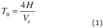
where H is the thickness of compressible strata and Vs their average shear wave velocity.
Within the context of large masses of compressible soils undergoing a process of regional consolidation, as in Mexico City, the spatial distribution of dominant periods may be used as an indicative parameter for recognizing zones of potential cracking. As discussed previously, cracks will appear in places underlain by soft lacustrine clays where the thickness of the compressible materials changes abruptly over short distances, as in the sharp transition zones, or in the presence of buried geologic structures, as described before. Under these circumstances, changes in dominant periods are governed mainly by changes in the thickness of clayey soils whereas changes in average shear wave velocity are four times less influential. Accordingly, knowing the spatial distribution of dominant periods within a certain region, zones of potential cracking may be identified by recognizing and characterizing the patterns with which dominant periods change.
It also follows that provided a consolidation processes is under way, the key factor for the appearance of cracks and fissures is the change of thickness of the compressible strata and, hence, identifying zones of potential cracking depends on the ability to obtain a reliable picture of the morphology at the contact of the hard or stiff materials that underlie the softer soils.
Depth of compressible strata
The best way to determine the morphology of the stiff base is to measure the depth of compressible strata directly from boreholes. However, a proper picture of the base materials configuration will generally require a somewhat large number of boreholes, a situation that can seldom be met in practice due to the practical difficulties of performing the drilling operations in many urban areas and, most importantly, by the costs they involve. Geophysics provides a variety of alternative indirect methods that can be used to estimate depths of soft strata and the overall stiff base morphology.
In connection to cracking and fissuring in consolidating soil masses, gravimetric studies have been performed in several important Mexican Cities, to determine the morphology of the stiffer strata underlying deformable soils (Arzate et al., 2006). Gravimetric surveys have the advantage of not being affected by urban infrastructure (electric cables, asphalt covered surfaces presence of buildings, etc); also, surveying devices need not be in direct contact with ground masses under study, a situation that can pose some difficulties in densely urbanized areas. Specialized high resolution equipment which is usually relatively expensive is necessary to obtain good results as well as highly qualified personnel to perform the surveys and interpret data.
Electrical resistivity distribution in the subsoil is highly sensitive to mineral composition, changes in porosity, and permeability (Meju, 2002, Mendoza et al., 2008, Hä et al. 2010). Electrical resistivity tomography has been used to map near surface features in Mexico City, for a variety of applications, including the identification of zones prone to be affected by cracking or fissuring (Arango–Galván et al., 2011). In urban zones electric induction induced by aerial or underground electricity cables, drainage and water pipes, buried installations containing metallic parts may contaminate signals. Ideally sensors would need to be placed underground, below all of these, which cannot always be done. Nevertheless, the technique is widely used and 2D and 3D electric tomography is a most valuable tool for mapping the interface between the soft lacustrine clays and the stiffer underlying strata in Mexico City.
The seismic refraction method can also be used but the presence of desiccated materials forming the surficial crust as well as the existence of layers of non plastic harder coarser sandy or silty soils interspersed between the very soft lacustrine clays can induce wave refractions well above the actual stiffer base materials. Ambient noise can preclude the possibility of defining properly arrival times of compression waves. All these make interpretation difficult.
Ground penetrating radar has also been used to map cracks and fissures in clay strata. It has been applied successfully in several locations inside the Basin of Mexico (Carreón–Freyre et al., 2003; Rangel–Miranda et al., 2003) and in Querétaro (Carreón–Freyre et al., 2006). The main limitation of this method as a tool for getting a picture of deep seated strata, is that it will only be effective to study the uppermost soil strata, i.e., surficial materials at depths seldom exceeding 10 m. Georadar tomography will also be affected by shallow buried urban infrastructure.
Noise measurements applied to determine the depth of compressible strata may be carried out with at least one broad band seismometer. Software to process data is public and is readily available. Interpretation of noise signals has been used extensively in the past and has been described previously and applied widely not only in Mexico but in many other Mexican cities (see, for example, Lermo and Chávez–García, 1993, 1994). As compared to the other techniques, noise measurements are cheaper and results can be produced rather fast, especially when operating several instruments simultaneously.
Summarily, locating and identifying zones of potential cracking should ideally involve a sequential procedure having at least the following steps:
1. Identify zones of potential cracking from topography, regional geology and geomorphology. Also identify man–induced processes that may influence the apparition of cracks, like regional subsidence produced by extraction of water from underlying aquifers, excavations and various types of constructions.
2. Apply noise measurements to obtain period maps and profiles to gain precision in the definition of zones prone to suffer from cracks.
3. Other geophysical techniques like the ones discussed above may follow to gain more accuracy in defining base rock or hard soil morphology.
4. Results may be calibrated or verified with borings or geotechnical soundings. Borings may also be combined and used simultaneously with any of the techniques mentioned previously.
Study case: San Lorenzo, Iztapalapa
San Lorenzo is located in the Iztapalapa hilly area in Mexico City at the foot of a volcanic structure known locally as Cerro de San Nicolás, as seen in figure 1. Recurrent cracks in San Lorenzo have damaged road pavements, water supply and sewage lines, as well as private property, mainly one level dwellings and higher rise structures, three to four stories high, founded on surficial foundations. Cracking may be enhanced by leaks from water supply and sewage pipe line and by water flowing through and around the fills that cover these pipes. Those fills, usually silts and silty sands, are frequently compacted well below acceptable standards. Filled cracks can re–open repeatedly, suddenly, and even violently mainly in the rainy season. Several catastrophic incidents of this nature have been recorded in San Lorenzo over the last few decades.
The photograph of Figure 3 illustrates the largest crack found up to date in San Lorenzo. It extends for about 850 m following a northeast–southwest direction, as indicated in Figure 4. Three other cracks, parallel to the first one, have been mapped. The cracks have damaged urban infrastructure (streets, sewage and water supply tubes and gas, telephone and electricity supply lines); they have also affected structures producing different degrees of damage. We refer to geotechnical studies and ambient vibration measurements regarding the effects of this family of cracks in what follows.
Geotechnical conditions
Geotechnical soundings were performed as part of the studies that were carried out in order to assess the damage caused to the taller structures and to suggest remedial measures. Twenty soundings were made, fourteen of them were CPT tests, and there were six mixed soundings in which CPT and SPT were combined. In CPT soundings or cone penetration tests, a conical tip is driven into the soil and a load cell installed near the tip is used to measure the soil's penetration resistance. Cone tip resistance is proportional to the soil's shear strength. SPT is the standard penetration test that is used to obtain mechanically disturbed samples of soil from which index properties can be obtained. The test is also used to determine the resistance of the soil to the penetration of a split barrel driven into it by impacts. Penetration resistance in this test is the number of blows required for a standard split barrel to penetrate 30 cm into the ground driven by a standard hammer of standard dimensions and weight. The hammer hits the barrel from a standard height.
The soundings revealed that low plasticity materials hardened by seasonal drying and wetting cycles form the topmost soil crust. Next in the stratigraphical sequence follow very soft and highly compressible lacustrine clays interspersed with packages of sandy silts and volcanic ash. The depth and thickness of the harder materials vary considerably. Basalt appears below all of these. The basaltic rock deepens as it goes from the northeast towards the southeast.
Seismic noise measurements
Two measurement campaigns were carried in August 2009 (47 measurement points) and later that same year, in October (76 points). Microtremor measurements were carried on both sides of the main crack, along a distance of about 1.4 km. The map in Figure 4 shows the relative position of the measuring points with respect to the main cracks.
Dominant periods were obtained at each of the points where we measured microtremors, applying Nakamura's technique. Results are summarized in Figure 4 which shows equal period contours. Analysis of the data presented in this figure revealed that dominant period gradients are higher at or close to the existing crack.
The apparition of a crack will redistribute stresses within a clay mass inducing tensions in zones adjacent to the main crack that may give rise to secondary cracks. Secondary cracks may also be associated to the morphology of the deep stiff strata. They may spread obliquely from an initial point and their surficial projection may cover a somewhat large area. This phenomenon requires further research, including detailed analytical studies into the mechanics of stress redistribution (see, for example, Rojas et al., 2002).
The map in figure 4 shows that the primary and secondary cracks fall within an area displaying the highest period gradients and the plot in figure 5 shows the spatial variation of dominant period along profile A–A' in figure 4. Dominant period varies fairly smoothly with a nearly constant gradient up to a distance where this gradient changes rather sharply. The point at which the gradient changes sharply coincides rather well with the location of the crack. A secondary crack is indicated at a point coinciding with a change in period gradient.
The geotechnical profiles obtained from field tests are consistent with dominant period profiles, as indicated in Figure 6. Proportionality of soil strata thickness and dominant periods can be observed by comparing these two figures, i.e. this corroborates that dominant period depends more strongly on stratum thickness than on shear wave velocity. Indeed, even if thickness changes abruptly, shear wave velocity values in the soft lacustrine clays will not change as sharply in the vicinity of a crack, for the case under study. Lacking measurements of shear wave velocity, we estimated these from CPT penetration resistance. Take, for example the CPT soundings in Figure 6; average shear wave velocities for the soft clays were estimated with:
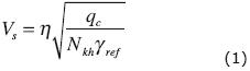
where Vs is the shear wave velocity in m/s; h is a constant that depends on soil type equal to 23 for this case; qc is the point penetration resistance measured in a CPT test; Nkh is a correlation coefficient equal to 9.5 and gref is the soil's volumetric weight. Derivation of equation (1) and discussion of the values of the constants involved have been presented elsewhere (Ovando and Romo, 1992).
Average shear wave velocities,  s, indicated in Table 1 were obtained from
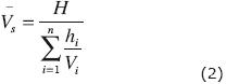
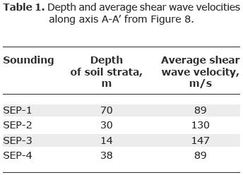
where H is the total thickness of compressible strata; hi is the thickness of an individual stratum having shear wave velocity Vl. Table 1 gives average shear wave velocities estimated with equations (1) and (2), using data from the CPT test results presented in Figure 6. As seen in the table, average shear wave velocity at or close to the crack (sounding SEP4) is very nearly the same as in the zone having deeper and thicker clay strata (sounding SEP1). Clays in the southern edge are thinner and harder (soundings SEP2 and 3). They are also interspersed with relatively thick lenses of sands, silts and silty sands. Hence, shear waves are considerably higher. Deformability of the clays in the south edge is far smaller in the southern portion as determined from one dimensional compressibility tests performed on clay samples extracted from soundings SEP1 and 2. It should be recognized that the morphology of the base rock determines the apparition of the crack and that the existence of harder, less compressible materials in the south edge also enhances cracking.
The graph in Figure 7 shows a depth profile obtained from the results of six geotechnical soundings along profile B'B (Figure 4), as well as the variation of dominant period along it. Results of these geotechnical soundings are given in Figure 8. Again, a sharp change in dominant period gradient coincides with the presence of a crack. We have also indicated zones where future cracks may appear in the future. Profile B'B runs nearly parallel to the secondary crack and, consequently, it was not possible to identify gradient changes associated to it.
The variation of dominant period along axis C'C of Figure 4 is given by figure 9. There were no geotechnical soundings along this axis. A crack observed there is indicated as well as the location of other zones of potential cracking in the future.
Discussion
It follows from the preceding analysis that cracking mechanisms in San Lorenzo are determined mainly from the morphology of the harder materials that underlie the much softer clays that were deposited above them. Dominant period was seen to depend on the thickness of compressible strata and on their compressibility or stiffness. The pattern in which dominant period varies spatially can be used to infer the morphology of the underlying harder materials from which zones of potential cracking can be readily identified, for a number of plausible situations.
We present some of the dominant period spatial variation patterns that can be expected a priori from a campaign of ambient vibration measurements in a typical transition zone in the Basin of Mexico. The upper left sketch in Figure 10 corresponds to a wedge of soft clayey soils in contact with harder materials that dip downwards with a constant inclination. In this case dominant period increases at an almost constant rate, as one goes from the shallower to the deeper clay strata. Potential cracking zones will appear around the places where tension stresses tend to concentrate, a situation that can be visualized with more detailed stress analyses; i.e., using elastic solutions or numerical models.
In the case of a dipping soft soil stratum over harder materials whose base changes in inclination, tension stresses and cracks will tend to concentrate at or around the place where the dip angle of the harder material changes, as illustrated in the upper right part of the same figure. A buried protuberance, natural (alluvial fans, rocky intrusions) or man–made (tunnels, large sewage pipes), will produce changes in the dominant period whereas a graben type configuration will produce the changes in dominant period as shown in the lower part of Figure 10. Some of these features can be identified in the actual period profiles shown previously in Figures 5, 7 and 9.
Conclusions
A large amount of the cracks that have appeared in the Basin of Mexico over the last few decades, are produced along the edges of the former lake system, in transition zones where the depth and thickness of soft clays strata vary sharply over relatively short distances. Buried geologic structures like alluvial fans or alluvial depositional cause ways may appear mainly at the bottom of hills that surround the lake, also in the transition zone. These buried geologic structures also contribute to the apparition of cracks since they induce tensional stress states as the clayey soils consolidate regionally because of pore water pressure reductions produced by the extraction of water from the underlying aquifer.
Analyzing the patterns in which dominant periods vary spatially, zones prone to crack can be identified, as shown here. Dominant periods, which vary's function mainly on the thickness of compressible soil strata, can be found applying Nakamura's technique to analyze microtremors.
The authors propose that cracking potential in and around the transition zones in the Basin of Mexico can be assessed by looking at the spatial distribution and the patterns of variation of dominant periods. This proposition was applied successfully studying the cracks that appeared in San Lorenzo, a location in the Ixtapalapa hilly area in south–east Mexico City.
Other dominant period variation patterns were presented and discussed. These simplified idealized patterns can be useful aids for assessing cracking potential in other locations.
Application of the technique presented here demands a relatively small effort but it does require the use of specialized measuring instruments, seismometers, preferably broad band devices (0.032 to 80 Hz). Compared with direct soundings for determining the morphology of basal hard soils or rocks, it constitutes a cheaper, faster alternative. It is also cheaper than other geophysical methods but its relative merits must be evaluated in future studies. In any case, use of noise measurements for identifying zones prone to crack in large consolidating soil masses can also be used in combination with other geophysical techniques.
Acknowledgements
Thanks are due to TGC Geotecnia, geotechnical consultants, who provided the results of the geotechnical soundings presented and discussed in this paper. The help of J. A. Martínez and L. A. Espinosa in processing noise signals is also duly acknowledged.
Bibliography
Aki K., 1957, Space and time spectra of stationary stochastic waves with special reference to microtremors, Bulletin of the Earthquake Research Institute, Tokyo University, 35, 415–457. [ Links ]
Aki K., 1988, Local site effects on ground motion, in: Earthquake Engineering and Soil Dynamics, II–Recent Advances in Ground Motion Evaluation, J.L. Von thun (editor), Geotechnical Special Publication No. 20 Am. Soc. Of Civil Eng., New York, 103–155. [ Links ]
Arango–Galván C., De la Torre–González B., Chávez–Segura R., Tejero–Andrade A., Cifuentes–Nava G., Hernández–Quintero E., 2011, Structural Pattern of subsidence in an urban area of the southeastern Mexico Basin inferred from electrical resistivity tomography. Geofísica Internacional 50–4: 401–409. [ Links ]
Arias A., 1990, "Agrietamiento del subsuelo en el vallede México" Tesis de maestría en Ingeniería (mecánica de suelos). División de Estudios de Posgrado de la Facultad de Ingeniería, UNAM, México, D.F. [ Links ]
Arzate J., Barboza R., López R., Pacheco J. Mata J.L., del Rosal A., Peña–Díaz I., Olivares C., 2006, Estudio Geológico–Geofísico para la evaluación de los hundimientos y agrietamientos en el área metropolitana Luís Potosí–Soledad de Graciano Sánchez. [ Links ]
Auvinet G., 1981, "Agrietamiento de las arcillas del valle de México", Informe técnico del Instituto de Ingeniería, UNAM, a la Comisión del Lago de Texcoco, México, D.F. [ Links ]
Auvinet G., Arias A., 1991, "Propagación de grietas", Memoria, Simposio sobre agrietamiento de suelos, Sociedad Mexicana de Mecánica de Suelos, México, D.F., pp. 21–32. [ Links ]
Auvinet G., 2008, "Fracturamiento de suelos, estado del arte", Memoria, Volumen especial "Conferencias temáticas: Avances recientes", XXIV Reunión Nacional de Mecánica de Suelos, Aguascalientes, México, pp. 299–318. [ Links ]
Auvinet G., 2009, "Land subsidence in Mexico City", Proceedings, ISSMGE TC36 workshop, "Geotechnical engineering in urban areas affected by land subsidence; The cases of Mexico City, Bangkok and other large cities", 9 de Octubre, pp. 3–11, Volume published by ISSMGE TC36, Sociedad Mexicana de Mecánica de Suelos and Instituto de Ingeniería UNAM, ISBN 978–968–5350–24–2, México, D.F. [ Links ]
Bonnefoy–Claudet S., Cornou C., Bard P.Y., Cotton F., Moczo P., Kristek J., Fäh D., 2006, H/V ratio: a tool for site effects evaluation. Results from 1–D noise simulations. Geophys. J. Int., 167, 827–837. [ Links ]
Cardarelli E., Cercato M., Cerreto A., Di Filippo G., 2010, Electrical resistivity and seismic refraction tomography to detected buried cavities. Geophysical Prospecting, 58 (4): 685–695. [ Links ]
Carreón–Freyre D.C., Cerca M., Hernández Marín M., 2003, Correlation of near–surface stratigraphy and physical properties of clayey sediments from Chalco Basin, Mexico, using Ground Penetrating Radar. Journal of Applied Geophysics 53: 121–136. [ Links ]
Carrillo N., 1948, "Influence of Artesian Wells in the Sinking of Mexico City", Proceedings of the Second International Conference on Soil Mechanics and Foundation Engineering, Vol. VII. [ Links ]
Chávez R.E., Cámara M.E., Tejero A., Barba L., Manzanilla L., 2001, Site characterization by geophysical methods in the archaeological zone of Teotihuacan, Mexico. Journal of Archaeological Science, 28: 1265–1276. [ Links ]
De Cserna Z., De la Fuente–Dunch M., Palacios–Nieto M., Triay L., Mitre–Salazar L.M., Mota–Palomino R., 1988, Estructura geológica, gravimétrica, sismicidad y relaciones neotectónicas regionales de la Cuenca de México. Boletín del Instituto de Geología, 104, 71 pp. [ Links ]
Díaz–Molina O., 2001, Determinación de zonas de riesgo geológico–ambiental en la Cuenca de México mediante sensores remotos y radar de penetración somera. Tesis de Licenciatura. Facultad de Ingeniería, UNAM. México, D.F. 89 PP. [ Links ]
Erdogan E., Demirci I., Candansayar M.E., 2008, Incorporating topography into 2D resistivity modeling using finite–element and finite–difference approaches. Geophysics, 73(3): F135–F142. [ Links ]
Hä H.S., Kim D.S., Park I.J., 2010, Application of electrical resistivity techniques to detect weak and fracture zones during underground construction. Environmental Earth Sciences, 60: 723–731. [ Links ]
Lermo J., Chávez–García F., 1993, "Site effect evaluation using spectral ratios with only one station", Bull. Seism. Soc. Am., Vol. 83, pp. 1574–1594. [ Links ]
Lermo J., Chávez–García F., 1994, "Site effect evaluation at Mexico City: Dominant period and relative amplification from strong motion and microtremor records", Soil Dynamics and Earthquake Engineering, Vol.13, pp. 413–423. [ Links ]
Marsal R.J., Mazari M., 1959, "El subsuelo de la ciudad de México", UNAM, México D.F. [ Links ]
Mazari M., 1996, La isla de los perros. México: El Colegio Nacional. [ Links ]
Méndez E., Auvinet G., Lermo J., 2008, "Avances en la caracterización geotécnica del agrietamiento del subsuelo de la Cuenca de México", Memoria, XXIV Reunión Nacional de Mecánica de Suelos, Aguascalientes, Vol. 2, pp. 495–502. [ Links ]
Mendoza J.A., Dahlin T., 2008, Resistivity Imaging in steep and weathered terrains. Near Surface Geophysics, 6(2): 105–112. [ Links ]
Meju M.A., 2002, Geoelectromagnetic exploration for natural resources: models, case studies and challenges. Surveys in Geophysics, 23: 133–205. [ Links ]
Nakamura Y., 1989, A method for dynamic characteristics estimation of subsurface using microtremor on the ground surface, QR of RTRI, 30, No.1, 25–33. [ Links ]
Pacheco J., 2007, "Modelo de subsidencia del Valle de Querétaro y predicción de agrietamientos superficiales", Tesis doctoral, Centro de Geociencias, UNAM, pp. 253. [ Links ]
Ovando E., Romo M.P., 1992, Estimación de la velocidad de propagación de ondas S en la arcilla de la ciudad de México con ensayes de cono, Sismodinámica, vol 2, 107–123. [ Links ]
Rangel Miranda D., Carreón Freyre D.C., Cerca Martínez M., Méndez Moreno, E., 2003, Valuation of Ground Penetrating Radar for the record of structures in fluvio–lacustrine soils. Journal of Applied Research and Technology. 1(1): 85–93. [ Links ]
Rojas E., Arzate J.A., Arroyo M., 2002, A method to predict the ground fissuring and faulting by regional groundwater decline. Engineering Geology, v.65, pp. 245–260. [ Links ]
Santoyo E., Ovando E., Mooser F., León E., 2005, Esquema geotécnico de la cuenca de México. México: TGC Geotecnia. ISBN: 968–5571–06–6. [ Links ]
Tamez E., 1992, "Hundimientos diferenciales de edificios coloniales en el Centro Histórico de la Ciudad de México", Undécima Conferencia Nabor Carrillo, Zacatecas, Sociedad Mexicana de Mecánica de Suelos, México. [ Links ]

