


Services on Demand
Journal
Article
 English (pdf)
 Article in xml format
 Article references
 Send this article by e-mail
Indicators
-
 Cited by SciELO
 -
 Access statistics
Related links
-
 Similars in
SciELO
Similars in
SciELO
Share

 Permalink
Geofísica internacional
On-line version ISSN 2954-436XPrint version ISSN 0016-7169
Geofís. Intl vol.49 n.1 Ciudad de México Jan./Mar. 2010
Articles
The application of electrical methods in exploration for ground water resources in the River Malacatoya sub–basin, Nicaragua
L. Sequeira Gómez1* and O. Escolero Fuentes2
1 Centro de Investigaciones Geocientíficas, Universidad Nacional Autónoma de Nicaragua, Apartado Postal A–131, Managua–Nicaragua, Centroamérica. * Corresponding author: lenersequeira@yahoo.es
2 Departamento de Geología Regional, Instituto de Geología, Universidad Nacional Autónoma de México, Ciudad Universitaria, Del. Coyoacán, 04510, Mexico City, Mexico
Received: April 24, 2008
Accepted: August 7, 2009
Resumen
En el contexto del cambio climático global, Nicaragua está siendo fuertemente afectada, manifestándose en la marcada variación temporal de los parámetros climáticos e hidrométricos. Como consecuencia de estas variaciones, en una franja paralela al Océano Pacífico que se extiende desde el extremo NO del Gran Lago de Nicaragua (Cocibolca) hasta los Departamentos de Madriz y Nueva Segovia (frontera con Honduras); las precipitaciones han disminuido notablemente en la última década, provocando intensas sequías y cambios en el régimen de vida de la población a lo largo de esta franja (que incluye a la sub–cuenca) a causa de la escasez del recurso hídrico, pues los niveles subterráneos y superficiales han disminuido notablemente. Esto ha incrementado la necesidad de explorar las fuentes de agua en la sub–cuenca desde la óptica de sistemas de flujo, aplicando técnicas hidrogeológicas, geofísicas e hidrogeoquímicas para crear un modelo conceptual del funcionamiento de dichos sistemas. Con este propósito, se desarrollaron 11 perfiles de Sondeos Eléctricos Verticales Continuos (SEVC) y 9 Sondeos Eléctricos Verticales (SEV), acompañados por una evaluación geológica. que en conjunto ha permitido identificar y caracterizar en profundidad y espacialmente las formaciones acuíferas presentes en tres sub–áreas de la subcuenca. De los resultados geofísicos se desprende que los mayores espesores acuíferos se determinaron en las unidades cuaternarias Río Malacatoya y Las Banderas (acuíferos no confinados). En dichas unidades el flujo es a través del medio poroso. En Teustepe, en las unidades terciarias Río Grande de Matagalpa, Cerro Oluma, La Libertad y Santa Lucía, el flujo prácticamente es a través del medio fracturado (acuíferos semi–confinados).
Palabras clave: Malacatoya, SEVC, Subcuenca, hidrogeoquímica, resistividad, acuífero.
Abstract
Nicaragua is being substantially affected by climate change, whose impact is to be seen in marked seasonal variations of climatic and hydrometric parameters. Rainfall has declined sharply over the last decade within a strip of land that runs parallel to the Pacific Ocean and extends from the extreme northwest of Lake Nicaragua (also known as Cocibolca) to the Departments of Madriz and Nueva Segovia and beyond the border with Honduras. Droughts and water shortages have changed the way of life of local inhabitants along the strip, which includes the Malacatoya sub–basin. Shallow aquifers and surface water levels have been notably reduced. This has increased the need to seek new water sources in the sub–basin from a flow–systems viewpoint, applying hy–dro–geological, geophysical and hydro–geochemical techniques to create a conceptual model of how the systems operate. This article describes the application of 10 Continuous Vertical Electrical Soundings (CVES) and nine Vertical Electrical Soundings (VES), accompanied by a geological evaluation. Taken together, these techniques permit the identification and characterization – in terms of space and depth – of the aquifer formations present in three sub–areas of the sub–basin. Geophysical results indicate that the thickest aquifers were to be encountered in the Río Malacatoya and Las Banderas quaternary units (unconfined aquifers). In these units, the flow is through porous media. In Teustepe, in the Río Grande de Matagalpa, Cerro Oluma, La Libertad and Santa Lucía tertiary units, the flow is through fractured media (semi–confined aquifers).
Key words: Malacatoya, CVES, sub–basin, hydro–geochemical, resistivity, aquifer.
Introduction
Infiltration and run–off conditions have changed as a result of extreme hydro–meteorological events, combined with many decades of uncontrolled human activity. This has been especially true in the wake of Hurricane Mitch, which had a marked impact on Nicaragua's general geomorphology, causing severe erosion in topographically high and medium–level areas, severe sedimentation at médium and low levéis, and modificadons in river courses. The result has included changes in the re–charging of aquifers and floods in such topographically low áreas as the villages of Las Banderas, El Brasil, Malacatoya and others close to the banks of the Río Malacatoya and Lake Nicaragua.
Steinich and Marín (1996) state that the use of electrical methods (VES's) in hydro– geological investigations is important in identifying the preferential groundwater flow patterns in accordance with the spatial anisotropy and depth of sub–soil. According to their research, lithologies with high permeability are identified by low electrical resistivities and vice–versa. Marín et al, (1998), also applied electrical methods to characterize porous media and determine preferential directions of hydraulic conductivity.
The area of the present study lies in the Malacatoya Sub–basin of Basin 69 in the center of Nicaragua, shared by the departments of Managua, Granada and Boaco, and with UTM coordinates 605000–650000 east and 1337000–1400000 north, zone 16 – NAD27 (Fig. 1). The aim of the present study is to characterize, in terms of depth and space, the Río Malacatoya Sub–basin (Nicaragua) by means of CVES and VES geophysical techniques (Fig. 2).
Geological setup
Geologically and geo–morphologically, the area is located within two provinces: the Nicaraguan Depression (Nicaraguan Graben) and the Tertiary Volcanic (Interior Highlands; United Nations, 1974; Fenzl, 1989).
Deposits of the Late Miocene to Quaternary cover the whole Nicaraguan Depression. Quaternary deposits also occur locally in Nicaragua's Central Region. The volcanic deposits of the Nicaraguan Depression form the Las Sierras Unit (Van Wyk de Vries, 1993). The Late Miocene to Quaternary, Malacatoya unit is formed by non–consolidated alluvial, fluvial and lake sediment (Fig. 1) that has been deposited in the Nicaraguan Depression since its formative stage. The quaternary Río Grande de Matagalpa Unit includes non–consolidated alluvial, fluvial and lake sediments of the Central Region (Fig. 1). Elming, et al., (1998). The quaternary deposits of the Nicaraguan Depression reach thicknesses of as much as 2,000 meters (Fenzl, 1988).
The Tertiary Volcanic Province (Fig. 1) is formed by the Coyol and Matagalpa groups. The Matagalpa Group, probably more than 2,000 meters thick, is characterized by rhiolytic to dacitic ignimbrites, pyroclastic sub–aerial deposits rich in accretions of lapilli and occasionally to thin epiplastic deposits in the Juigalpa and Cuapa units. The Cuapa Unit is of a dark brown–violet color, while the Juigalpa Unit includes light–green sub–aerial pyroclastic deposits inter–stratified with reddish–brown pyroclastic flows. The increase in thickness of individual pyroclastic flows of the Juigalpa Unit, from 10 to 50 meters over a distance of 20 kilometers, indicates another possible source north to north–east of Cuapa. Large volumes of basaltic to andesitic fragments in the pyroclastic flows are interpreted as indicating an older basaltic to andesitic volcanic terrain. The Matagalpa Group is traversed by many north–west to west–northwest striking normal faults, which complicate the mapping of individual strata (Elming, et al., 1998).
The Coyol Group is characterized by plateaus of rhyolitic to dacitic pyroclastic flows, basaltic and andesitic lava, breaches and agglomerates. This group is traversed by northeast–leaning valleys where silicene pyroclastic deposits of the underlying Matagalpa Group reach the surface (Ehrenborg, 1996). Ignimbrites shield deposits of the Coyol Group, dominated by dacitic to rhyolitic pyroclastic flows, are known as the Las Maderas Unit. This type of deposit is only found to the west and northwest of Teustepe with good exposures along the Pan–American highway north of Las Maderas where they are interstratified by basaltic to dacitic lavas of the La Libertad Unit. The La Libertad Unit, and the younger Santa Lucía Unit comprise 85% of the strato–shield volcanic terrain. The remaining 15% is included in the Cerro Oluma Unit where it is difficult to differentiate basalts–andesite of the Santa Lucía Unit from those of the La Libertad Unit (Elming, et al., 1998).
The Coyol and Matagalpa units are sub–alkaline. The stratiform–shield volcanoes of the Coyol Group exhibit low–K toleitic, as well as calco–alkaline, characteristics. Geochemical characteristics could reveal a low–K toleitic evolution to calco–alkaline compositions (Ehrenborg, 1996). The age of the Coyol Group varies 12 and 18 millions of years (My) and for the Matagalpa Group 50.8, with a margin of error in the latter case of 1.6 My (Elming et al, 1997). The central and southern sectors of the province are mainly covered by tertiary volcanic deposits (toba, basalts, andesits and ignimbrites) that belong to the Matagalpa and Coyol groups, generally lying on top of the tertiary sedimentary formations. The thickness of this group is less than 2,300 meters (Fenzl, 1988).
Surface and subterranean hydrology
From north to south, drainage is provided by the River Malacatoya and its tributaries (El Fonseca, Santa Rita, Cusirisna, Sapomeca, El Barco, El Murciélago, El Guayabal, La Mona, El Acoto, Los Potreros and the Ayojá). The principal economic activities are the cultivation of crops, rearing of livestock, and a little non–metallic mining. Water is obtained from both subterranean and surface sources.
Nicaragua is divided into two major hydrographic regions: thePacific side (12,072 km2) and the Atlantic side (116,882 km2), which belongs to the Malacatoya sub–basin. The nation's most important groundwater deposits consist of the quaternary formations in León–Chinandega, the Carazo Plateau and the Nicaraguan Depression, to which the Malacatoya Sub–basin pertains. Secondary deposits are to be found to the south of the Pacific side, mainly in the Rivas anticline; the Tertiary Volcanic Province (valley deposits, such as those of Sébaco, el Sauce, San Juan de Limay and Estelí); and the Atlantic Coast Geological Province (extensive but thin fluvial–coluvial deposits with low transmission levels). The Nicaraguan Depression is a region with major potential for economic development and excellent prospects for the exploration of groundwater sources. The tertiary volcanic rocks (Coyol and Matagalpa Group) that predominate in the Interior Highlands have failed to develop extensive continuous aquifers because of their adverse hydrodynamic conditions. Access can be had only to small local aquifers developed within the systems of fissures, cracks and diaclases, or in porous rock within the volcanic sequence. These small aquifers can provide sufficient water only to meet the needs of small communities. The accidented relief and intensive deforestation of some basins restrict water filtration rates, leading to the formation of aquifer zones of a certain importance. The presence of ancient buried soils (paleosoils) and meteorized rock, alternating with layers of fresh or only slightly meteorized rock, favors the formation of hung aquifers which, on being cut in the gullies and ravines, give rise to springs in the uplands. The hydro–geological characteristics of the Tertiary Cretaceous rocks that lie below the Coyol and Matagalpa Tertiary volcanic rocks are pretty well unknown. However, considering their lithological similarity to the Mesozoic–Cretaceous rocks of the Rivas anticline, it can be assumed that they are deficient in water resources (Fenzl, 1988).
The Tipitapa–Malacatoya aquifer reaches depths of up to 120 meters, transmission rates of between 1,500 and 1,700 m2/day and freatic levels of between 1 and 20 meters. Production of existing wells varies between 2,158 and 12,673 m3/day. Transmission rates of between 400 and 450 m2/day were recorded close to the village of Las Banderas and values of between 1,500 and 1,700 m3/day have been registered between the River Malacatoya and Lake Tisma. The range of existing capacity so far registered oscillates between 3 and 50 m3/h/m. Values lower than 10 m3/h/m are to be found in the northern sectors and the higher ones in the central sector and downstream, especially near the River Malacatoya (40–50 m3/h/m). Storage coefficients found in this región range between 4 x 10² and 26 x 102. The higher values have been registered in the Tipitapa–Tisma sector (22–26 x 102) and the lowest in Panaloya–Malacatoya (4–6 x 10²). Table 1 sums up the hydro–geological characteristics of the area under study (Fenzl, 1988).
Stratigraphic and hydrogeological conceptual models
The well lithology suggest that the hydro–geological system in Malacatoya consists of two highly permeable aquifers (Fig. 3). One is shallow and very thick (40 meters) and the other is deeper (10 meters), both formed by quaternary (Qm) deposits of the Río Malacatoya Unit (sand, gravel, conglomerate, light and porous limestone, and chalky material). In this area, the phreatic lev el that was measured in excavated wells ranged from 10 to 20 meters. In Las Banderas, three aquifers (shallow, medium and deep) were identified, all of them highly permeable. They are constituted by quaternary deposits (Qlb) of the Las Banderas Unit (muddy sand, sandy clay and alluvial deposits). Within this area, the size of the aquifer particles increases with depth, and the phreatic level that was measured in excavated wells ranged from 5 to 15 meters. The non–consolidated tertiary formation of the final stratum (60 meters in depth) possibly corresponds to the Coyol Group, given that the Santa Lucía Unit (Ts) surfaces nearby. Two aquifers were identified at Teustepe with variable permeability and transmisivity (from high to nil); a shallow aquifer (15 meters thick) formed by quaternary deposits (Qg) of the Rio Grande de Matagalpa Unit (clay, sand and volcanic conglomerates), and a deeper aquifer (less than 10 meters thick) formed by tertiary deposits (Ts) of the Santa Lucía Unit (fractured rock). The last stratum possibly corresponds to the hydro–geological base (Santa Lucía Unit).
Data acquisition
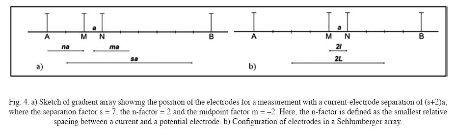
With this in mind, CVES geophysical techniques were applied with the gradient array and VES with the Schlumberger array (Fig. 4).
The main objective in using both types of sounding was based on the fact that in the Río Malacatoya Sub–basin, the aquifer formations are generally no more than 50 meters deep, above all in the tertiary formation of the Coyol and Matagalpa groups, where the CVES method can be perfectly well applied to achieve greater precision in the location of granular formations that are not very thick and in fault zones where groundwater flows occur. In Teustepe, the VES method was used as an auxiliary to the CVES in order to identify the tertiary formations. In Las Banderas and Malacatoya, the CVES method was applied in order to achieve greater precision in the demarcation of the strata in the first 60 meters composed of recent pyroclastic and alluvial deposits (Nissen, J., Elming, and Enström, 1986) while the VES method was used to reach depths of more than 100 meters, given that the thickness of the alluvial deposits in Malacatoya is approximately 120 meters (Fenzl, 1988).
The ABEM Lund Imaging System (Dahlin 1996) was used with gradient array (Fig. 4) to carry out 10 CVES's in a west–east direction (Fig. 2) with a minimum spacing between electrodes of 5 meters, and a minimum length of 400 meters and maximum of 3,500 meters. The system consisted of an information storage system (Terrameter SAS 4000), a switching unit to select the geometry of the arrays automatically, four multi–connector cables, 81 electrodes and 81 connector and inter–connector cables. In order to achieve an approximate depth of 65 meters with the gradient array, the profile's minimum length is 400 meters. In order to lengthen the profile, use was made of the roll–along technique (Dahlin, 2001).
A multi–electrode investigation with the gradient array was performed by injecting current to earth by electrodes with a "(s+2)a" separation (Fig. 4) and simultaneously or sequentially measuring all the differences in voltage among the voltage "a" electrodes. Here the separation factor "s" is a whole number that corresponds to the maximum number of potential readings for an injection current. The "n" factor can be defined as the relative spacing between the dipole voltage and the nearest current electrode. It is also practical to define the "m" or median point as the intermediate position of the voltage dipole closest to the intermediate point between the two current electrodes (Dahlin, T. And Zhou, B., 2006).
The large amount of data produced by the multi–electrode system renders automated processing necessary. In this study, the data was fed into the Res2dinv program, which uses the minimum squares method (Loke et al. 2003). The overflow model was presented by means of quadratic error. Data feed used paramaters predefined by the Gauss–Newton method to calculate the matrix of sensibility in all the repeats (Dahlin, and Zhou, 2006).
Nine VES 's (Fig. 2) were carried out in the area using a Terrameter SAS 4000 with Schlumberger array (Fig. 4b), which provided more lithological information in terms of depth while calibrating the geophysical information together with the CVES and well lithology. The maximum AB length used was 800 meters. In the Malacatoya and Las Banderas sub–areas, the orientati on of the corresponding VES's is the same as that of the CVES. In Teustepe in particular, the VES's do not coincide with the CVES.
The quadratic mean error (rms) in the one–dimensional inverse model of the VES's is between 1,5% and 7,7% (fig 6, 7 and 9). In the CVES, rms in the data acquisition was restricted to less than 2% and in the bidimensional inverse model rms it is between 2,7% and 9,4% (fig 5, 7 and 8).
Results and discussion
The present study displays the results of 11 CVES's conducted from west to east with integrated topography (Fig. 5, 7 y 8) and nine VES's (Fig. 6, 7 y 9). Because of the geology itself and the distances between each site, the results have been grouped into three sub–areas for ease of interpretation: Malacatoya, Las Banderas and Teustepe (Fig. 2). In correlating the results from the 2D modeling of the CVES and the ID modeling of the VES's with the information on well lithology (Fig. 4 and Appendix 1) in each of the sub–areas (INETER, 2005), five units were identified, here named A, B, C, D and E (Fig. 5e). In each sub–area, the granular aquifer formations are identified by the letter B, fractured aquifers with the letter E, and the aquitards with A, C and D. In this study, the static levels (SWL) measured in the excavated wells are less than 20 meters. In general, according to the results that were obtained, it is to be expected that the electrical resistences of the hydrogeological base are greater than 300 ohm–m (resistive base).
Data was interpreted by RESIXPLUS using the Inman (1975) inversion scheme, which adjusts data to theoretical stock to balanced minimums. In this case, inversion was supported by well information, taking account of the static water level (SWL), lithology and thicknesses of lithological groups in correlation to resistance ranges obtained from the CVES and VES's.
Compared with the CVES, the VES 's are more sensitive of lateral geological variations. As a result, they are less precise in measuring the limits of vertical and horizontal geological boundaries, since they are applicable in land that generally is horizontally stratified or with inclines of less than 15°. These factors contribute to producing results that are inconsistent with the CVES. However, when their interpretation is supported by geological and lithological information in the area under study, the VES 's provide a good approximation of the physical nature of the sub–soil and establish a good physical–geological correlation. For hydro–geological/geo–physical interpretation, this study has defined particular resistivity ranges for each sub–area (tables 2 and 3).
Malacatoya sub–area: None of the images shows that the hydrogeological resistivity basement has been reached (Nissen, J. et al., 1986). It is located at 120 meters (Fenzl, 1988), and is perhaps composed of quaternary sedimentary or tertiary rocks of the Coyol Group.
The final models are shown in the fig. 5, and the RMS misfit ranges from 2.7% to 7.1%. In the images, as is to be expected in low basins, the strata are seen as continuous in the mid–section (Fig. 5b–5f), though not in the proximity of the watershed, where there is severe fracturing (Fig. 5a), through which flows of groundwater from neighboring basins may be taking place.
On the basis of the CVES results, ranges of electrical resistivities can be defined incorrespondenceto lithological packages (Table 2), with their respective hydrogeological interpretation. In Figs. 5b and 5e the phreatic level can be clearly seen to be located at a depth of less than 20 meters; the upper limit is unit C, principally composed of organic soil, plastic clay, limestone and boulders. No defined phreatic level is to be observed in Fig. 5a due to fracturing of the terrain. In the images of Figs. 5c and 5d, the phreatic level seems to be very superficial. This is not, however, accurate because the level that was measured in the calibrati on well was at 17 meters. The contradiction can be explained by the infiltration of water from rice irrigation. In CVES Malacatoya 6 (Fig. 6), the phreatic level corresponds to the measurement of a well that was excavated nearby (5 meters). VES's 1, 2 and 3 (Fig. 6) on the Malacatoya CVES 1, 3 and 5, consistent with the previous results (Table 2). The thickness of the aquifers ranges from 20 to 50 meters. On the basis of these results, it is possible to conclude that the Malacatoya aquifers are not confined.
Las Banderas sub–area: The geophysical study was conducted on the pyroclastic flow (Qlb), which is homogenous, about 20 meters thick, and consisting of a mixture of black volcanic rocks, and andesitic and dacitic gray–white pumice (Ehrenborg, J., 1996). According to measurements taken in the wells that were dug, the phreatic level in this unit lies at between 10 and 15 meters (Fig. 7). The geo–electric results do not reflect deep horizontal stratification; rather they reflect irregular surfaces (Fig. 7a) of the subsoil in areas near the Río Malacatoya and flatter surfaces west of the river (Fig. 7b). Indications of the hydrogeological base cannot yet be appreciated with the CVES. Results of the VES are consistent with previous ones but are strongly affected by the lateral variations that predominate in the area. Aquifer thicknesses range from 30 to 55 meters. A summary of hydro–geological interpretation is presented in Table 2 on the basis of the CVES conducted in the area. In none of the preceding cases was it possible to reach the hydrogeological base, which would be reflected in resistivities very superior to 300 ohm–m. The aquifers are not confined.
Teustepe sub–area: The phreatic levels that were measured at Teustepe are less than 10 meters (Figs. 8 and 9). Table 2 summarizes the corresponding geophysical and hydrogeological interpretation. The Teustepel CVES (Fig. 8a) was done on the Río Grande de Matagalpa (Qg) Unit, perhaps overlaying the Cerro Oluma (To) and La Libertad (Tl) units. In the image of the resistivity generated by the CVES, one may observe the quaternary (Qg) covering of variable thickness throughout the profile, overlaying the severely fractured tertiary rocks (To and Ti) through which the water flows preferentially.
The Teustepe2 CVES (Fig. 8b) was done to the west of the area on the Las Maderas unit (Tm) overlaying the Santa Lucía unit (Ts). The profile is on a zone of intense thermal activity in a northwest–southeast direction that reaches 41.6°C some 300 meters to the north measured at the M5 spring. The thermal processes markedly modify the sub–soil's properties in this location, resulting in a strong contrast with the Teustepe1 resistivity image. Major flows of groundwater are to be observed in the region. In the resistivity image, including in the zones marked as granular aquitards (A), this can be assumed to correspond to fractured and very distorted tertiary rocks through which groundwater flows at temperatures similar to those mentioned above.
On the Río Grande de Matagalpa (Qg) Unit and overlaying the Santa Lucía Unit (Ts), on the limit of the thermal zone, CVES Teustepe3 was conducted with less of an influence from the thermal processes. The phreatic level measured at this location is close to 3 meters deep.
As with the Teustepe2 profile, the tertiary rocks (Ts) must be distorted by the hydrothermal processes at depths greater than those studied here using electrical methods.
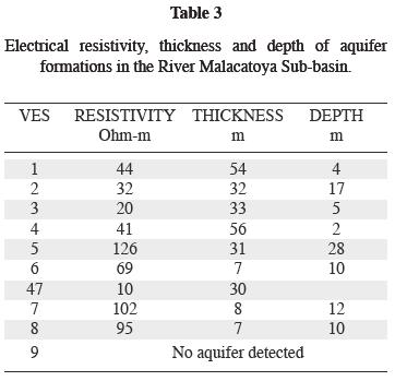
In Teustepe, the VES 's were applied with the aim of knowing the response of the tertiary rocks and therefore the hydro–geological base. At the depths that were studied in this investigation, the results (VES 6, 8, 9 and 10) of electrical resistivities of less than 100 ohm–m suggest a fractured médium with groundwater flows. Because of the high electrical resistivity of the last layer, VES 7 appears to have reached the hydrogeological base. The information obtained, however, is insufficient. Table 2 sums up the hydrogeological/geophysical interpretation of Teustepe. Here, in general the aquifers are not confined. Using the detailed results of the VES's, Table 3 presents a summary of the main parameters of the aquifers in the areas in question.
Conclusions
The geophysical research was undertaken in the Río Malacatoya, Las Banderas and Río Grande de Matagalpa Quaternary units, and in the Cerro Oluma, La Libertad, Las Maderas and Santa Lucía Tertiary units. The thickest aquifers (56 meters) were found to be in the first two units, where the flow is through the granular médium formed by pyroclastic flows (Pleistocene–Holocene), non–consolidated sedimentary rocks, alluvial, fluvial and lake deposits (Late Miocene to Quaternary) that generally constitute continuous aquifers. In the Tertiary units, the groundwater flow is mainly through the fractured media of the Coyol and Matagalpa groups. Here it was not possible to determine the fractured thickness.
From the geophysical results, it is inferred that the aquifers in the three subareas are unconfined. It was also found that, in the other geological units, the flow is predominantly through the fractured tertiary medium (Ts, Tl, Tm and To), covered by nonconsolidated sedimentary rocks (alluvial, fluvial and lake deposits) of the Río Grande de Matagalpa unit.
The phreatic levels measured at Malacatoya and Las Banderas are less than 20 meters and at Teustepe less than 10 meters. In general, at locations where geophysics was applied, the hydrogeological base could not be reached.
The application of geophysics (calibrated electrical procedures) in hydrogeological research with the lithology of well and geological information is very important in defining, in spatial and depth terms, the type of lithology through which groundwater moves.
Acknowledgements
This research was undertaken under the auspices of the National Autonomous University of Nicaragua's Geoscientific Research Centre (CIGEO/UNAN–Managua) and the Universidad Nacional Autónoma de México (UNAM), through its Instituto de Geología and the Programa de Postgrado en Ciencias de la Tierra.
Bibliography
Dahlin,T., 1996. 2Dresistivity surveying for environmental and engineering applications: First Break 14, 7, 275–283. [ Links ]
Dahlin, T., 2001. The development of DC resistivity imaging techniques. Computers & Geosciences 27, 1019–1029. [ Links ]
Dahlin, T. and B. Zhou, 2004. A numeri cal comparison of 2D resistivity imaging with 10 electrode arrays. Geophysical Prospecting, 52, 379–398. [ Links ]
Dahlin, T. and B. Zhou, 2006. Multiple–gradient array measurements for multichannel 2D resistivity imaging. Near Surface Geophysics, 4, 113–123. [ Links ]
Dengo, G., 1973. Estructura geológica tectónica y morfología de América Central: Instituto Centroamericano de Investigación y Tecnología Industrial (ICATTE). Managua, 1968 y 1973. [ Links ]
Ehrenborg, J., 1996. A new stratigraphy for the Tertiary volcanic rocks of the Nicaraguan highland: Geological Society of America Bulletin, 108, 830–842. [ Links ]
Elming, S.–Å., L. Widenfalk and D. Rodríguez D., 1998. Investigación geocientífica en Nicaragua. Proyecto conjunto Suecia–Nicaragua durante el periodo 1981–1991. [ Links ]
Elming, S.–Å., P. Layer and K. Ubieta, 2001. A Paleomagnetic study and age determinations Tertiary rocks in Nicaragua, Central America. Geophysical Journal International, 147, p. 294–309. [ Links ]
Fenzl, N., 1988. Nicaragua: geografía, clima, geología e hidrogeología: Belém, UFPA/INETER/INAN, 1988, p.62. [ Links ]
INETER, 2005. Archivo de pozos de Nicaragua. Dirección General de Recursos Hídricos. [ Links ]
INETER, 2005. Resumen meteorológico anual: Instituto Nicaragüense de Estudios Territoriales. Dirección General de Meteorología. [ Links ]
Inman, J. R., 1975. Resistivity inversion with ridge regresion: Geophysics, 40, 5, 798–817. [ Links ]
Loke M. H., I. Acworth and T. Dahlin, 2003. A comparison of smooth and blocky inversion methods in 2–D electrical imaging surveys. Exploration Geophysics 34, 182–187. [ Links ]
Loke, M. H., 1999. Rapid 2D resistivity and IP inversion using the least–squares meted. Geoelectrical Imaging 2D and 3D: Software manual, p.81. [ Links ]
Marín, L. E., B. Steinich and M. J. Barcelona, 1998. Hidrogeologic site characterization using azimuthal resistivity surveys: Journal of Environmental & Emgineering Geophysics 3, 4, 179–184. [ Links ]
McBirney, W., 1966. Volcanic history of Nicaragua: Universidad de California. [ Links ]
Naciones Unidas, 1974. Investigaciones de aguas subterráneas en la región de la costa del Pacífico de Nicaragua. Volumen 1, Informe técnico, Zona de Chinandega. [ Links ]
Nissen, J., S.–Å. Elming and A. Enström, 1986. Geoelectric deep soundings in Nicaraguan Depression zone. Swedish Geological Company, ID–nr: URAP 86005, 16pp. [ Links ]
Steinich, B. and L. E. Marín, 1996. Hydrogeological investigations in northwestern Yucatan, Mexico, using resistivity surveys: Ground Water 34, 4, 640–646. [ Links ]
Van Wyk de Vries, B., 1993. Tectonic and magma evolutions of Nicaraguan volcanic systems: PhD. thesis, Dep. of Earth Sci., Open Univ. p.327p. [ Links ]

