


Servicios Personalizados
Revista
Articulo
 Inglés (pdf)
 Artículo en XML
 Referencias del artículo
 Enviar artículo por email
Indicadores
-
 Citado por SciELO
 -
 Accesos
Links relacionados
-
 Similares en
SciELO
Similares en
SciELO
Compartir

 Permalink
Frontera norte
versión On-line ISSN 2594-0260versión impresa ISSN 0187-7372
Frontera norte vol.22 no.44 México jul./dic. 2010
Artículos
Distribution of the Waters of the Rio Grande between Mexico and the United States in the Fort Quitman–Ciudad Juarez Area
El reparto del agua del río Bravo entre México y Estados Unidos en la zona Fort Quitman–Ciudad Juárez
José Luis Escobedo Sagaz* y Rosario Haydee Pérez Espejo**
* Profesor–investigador de la Universidad Autónoma de Coahuila Dirección electrónica: lanzas_98@yahoo.com
** Investigadora de la Universidad Nacional Autónoma de México Dirección electrónica: espejo@servidor.unam.mx
Fecha de recepción: 21 de octubre de 2008
Fecha de aceptación: 10 de julio de 2009
Abstract
This article demonstrates some of the problems that arise in an economic analysis of the distribution of surface water when a river basin is shared by several countries. A case study is presented on the distribution of surface waters from the Rio Grande, which marks the border between Mexico and the United States, to determine whether there are non–cooperation strategies in relation to the Convention of 1906 for the Equitable Distribution of the waters of the Rio Grande for Irrigation Purposes. Water flows are analyzed by using a time series for observing cooperative behavior representing a Pareto optimal outcome.
Keywords: International water agreements, transboundary basins, common–pool resources, Convention of 1906, Mexico–US border.
Resumen
Este artículo muestra algunos problemas que surgen a partir de un análisis económico sobre la distribución del agua superficial de un río cuando su cuenca es compartida entre varios países. Se presenta un estudio de caso de la distribución de las aguas superficiales del río Bravo, el cual delimita la frontera entre México y Estados Unidos, para determinar si hay estrategias no cooperativas de acuerdo con la Convención para la equitativa distribución de las aguas del río Bravo para fines de irrigación de 1906. Los flujos de agua son analizados por medio de series temporales para observación del comportamiento cooperativo representando un resultado óptimo de Pareto.
Palabras clave: Acuerdos Internacionales de Agua, cuencas transfronterizas, recursos de uso común, Convención de 1906, frontera México–Estados Unidos.
INTRODUCTION
Mexico and the United States have strong economic, social and environmental ties that frequently cause conflicts between their governments and populations. This situation is more intense along the border, where societies share territory, problems, opportunities and personal connections, and where there are high rates of population growth, especially on the Mexican side of the border, although the most recent censuses suggest these rates are declining.
Demographic growth causes increasing pressure on the region's natural resources, and this is particularly true for water. Aquifers are being over–exploited and the volume of surface water is diminishing, leading to recurrent controversies between the two governments.
There is a long history of water conflicts between Mexico and the United States. The two governments have been addressing these conflicts since at least the late 19th century, generating agreements and institutions, some of which continue in effect today and regulate the use of surface water.
The problem of water management along the Mexico–US border has prompted studies questioning the performance of such institutions, analyzing their impacts on the environment, the economy and natural resources. However, the institutions' impact on the population's welfare, from an economic point of view, has not received the necessary attention.
The purpose of this article is to determine whether there is a loss of welfare in Mexico associated with the way in which Mexico and the United States use surface water in accordance with the Convention of 1906. To this end, the game theory will be used to demonstrate the existence or absence of strategies linked to an equilibrium characterized by a Pareto optimal.
This article is organized into four sections. The first section presents theoretical elements regarding the problems in analyzing water from a perspective of the economy and transboundary basins. The next section describes the way in which states determine their strategies for dealing with other states, affecting the possibilities for emerging cooperation. The third section gives a brief description of the institutional framework in the Rio Grande basin area. The last section presents an analysis of the surface water flows from the Rio Grande in the El Paso–Fort Quitman area, to detect the existence of cooperation strategies.
POLITICAL–ECONOMIC ELEMENTS IN TRANSBOUNDARY BASIN MANAGEMENT
In the analysis of water systems it is necessary to move away from the typical strategies in economic theory, in which goods are private and it is possible to achieve an appropriate re–allocation of resources by using markets, whether or not they are regulated, or by establishing taxes and fees.
Water has particular characteristics to take into account when planning the management of this resource: 1) movement and uncertainty in water availability; 2) economies of scale; 3) competition among a diversity of uses; 4) general interdependence among users; and 5) the unidirectional, asymmetrical nature of the inter–relationships and inter–dependencies among the uses and users of this resource (Solanes and Jouravlev, 2005:24). We should also add to this list that there are no substitute goods for most uses of water and that water consumption is absolutely necessary for human beings.
Together, these characteristics allow us to observe a series of phenomena, and while there is no direct causal relationship, we can affirm that the first characteristic listed generates uncertainty and imperfect information among users, while the second one allows for monopolies to exist, and the fifth is associated with the existence of externalities. Furthermore, there are social and environmental injustices and inequalities, and distortions in markets, and these can be found to a greater or lesser extent in the sub–sectors within the water sector.
In general, three sub–sectors can be identified: 1) water supply sources, 2) distribution, and 3) consumption. There is no defined vertical relationship among these sub–sectors, and their order can vary when, for example, some consumption processes allow for the recuperation of supply sources.
There are two types of water sources that can be managed within a given basin: the sources of surface water, including rivers, lakes and lagoons,1 and sources of underground water. It can be argued that treated water is another source, however it comes from or flows from one of the two other types of sources mentioned or is re–introduced into the system.
Distribution consists of transporting the water from supply sources to the points of consumption. In the case of underground waters, this sub–sector may be small or not even exist, since the water source is located at the point of consumption. This sub–sector may be a primary destination for investments In areas with scarcity of water, since it would otherwise be necessary to import water from distant surface or underground sources.
Finally, there are four types of use within water consumption: 1) domestic, destined for consumption according to families' needs; 2) agricultural production; 3) industrial production; and 4) environmental and navigation services, in which water is not usually transferred from the supply source. This classification is based on what was presented by the National Water Commission (Comisión Nacional del Agua—CNA, 2003), for the first three uses. The fourth use has been added to incorporate a paradigm that attempts to make water use economically and socially sustainable (Toledo, 2002), that should be included in the perspective promoted by Mexico's legislation.
In Mexico, the National Waters Act of 2004 (Semarnat, 2004) stipulates that Watershed Councils will define the order of priority among the various water uses. Until they indeed make those determinations, the following order will be observed: 1) domestic, 2) urban public, 3) livestock production, 4) crop production, 5) ecological conservation or environmental use, 6) electricity generation for public use, 7) industrial, 8) aquatic, 9) electricity generation for private use, 10) washing and silting of land, 11) tourism, recreation and therapeutic purposes, 12) multiple uses, and 13) others.
Each of the sub–sectors mentioned is facing problems that depend on specific conditions in their environment. In the region under study, the most important problems lie in the supply sources, since population growth means that the rate of extraction is higher than the recuperation rate, and the dynamics of development increase the demand for this resource.
The CNA identifies the following problems in the use of water in the Rio Grande planning region (CNA, 2003:80–84): 1) unfavorable natural conditions, 2) socioeconomic conditions not in accordance with the availability of water resources, 3) precarious availability of water caused by a higher demand than the available supply in urban areas, 4) inadequate, low efficiency use of water, 5) insufficient development in water management that fails to correspond to the challenges proposed.
The resources in an economy cannot always be analyzed from a market perspective, since because of their nature, it is not always possible to establish a price system. Ostrom, Gardner and Walker (1994:7) identify two important characteristics for defining different types of goods: a) the difficulty in excluding individuals from the use of a good and the benefit generated, and b) the subtraction of goods consumed by an individual prevents its use by other agents.
Exclusion signifies that given the characteristics of a good and the corresponding institutional legal framework, potential beneficiaries or users can be prevented from consuming the good or the service when it has been allocated to other individuals. In order for this to take place, there must be a series of property rights that can be defended, both legally and economically, in the framework of a legal system that is valid for all individuals. The typical example used in this case is how to prevent livestock belonging to a given community from entering the pastureland of another community.
Subtraction implies that the consumption of a good by a given agent will have the effect that another will not be able to make use of the good. For example, if a fisherman catches x number of fish, this amount will no longer be available for other fishermen.
On the basis of these two situations, we can identify four types of goods:
1. Public goods. Exclusion is unlikely or non–existent, and subtraction is minimal or null. For example, radio waves can be considered as pure public goods, since it is impossible to prevent anyone who has a radio from listening to the signal emitted. And, the fact that someone listens to the radio does not prevent anyone else from also listening.
2. Private goods. Exclusion is simple and subtraction is high. These types of goods are those that can be best analyzed using neoclassic economic theory.
3. Toll goods. Exclusion is simple and subtraction is low. Here an example would be public libraries, where access to the use of their services is subject to a series of requirements that make it likely that some potential users will remain excluded, however the consumption of services by a user does not necessarily mean that other registered users will not have access to those services.
4. Common–pool resources. Exclusion is unlikely and removal is high. A forest would fit in this category: the cost of preventing loggers from cutting down trees is high, and once the trees have been cut down, they cannot be used by other agents.
This classification is not unchangeable, since the boundaries between the different types of goods are not rigid or precise. Under certain circumstances a good might fit within one category, and under other circumstances it might fit within another. Buck (1998:5) gives the example of a lighthouse that warns someone when they are coming close to the shore. It is impossible to prevent anyone from having access to this service, so it can be considered a public good. Ships that are near the shoreline must reach a port at one time or another, and they can do this with a certain regularity. As the number of ships using this service increases, it becomes necessary to install better lighthouses, and thus ships arriving at a port may be charged a fee, with the aim of improving lighthouses. This service would then come close to qualifying as a toll good.
In the case of surface water in a river basin, it should be considered a common–pool resource for the users who are located in the basin or who have some type of physical connection with the basin, since once they are in this situation, they cannot be easily excluded. In the case of two farmers whose land is located along the banks of the same river, for example, it is impossible to prevent one of them from having access to the resource. It can be argued that when property rights are granted in territory where the water for different users is located, these problems can be avoided, since access to the resource is blocked, serving as a type of exclusion. However, guaranteeing that these rights are respected can be a costly task, since constant surveillance of these territories becomes necessary. Thus, exclusion is not an easy process, and does not solve the problem between farmers possessing such rights.
In relation to the other characteristic, we can observe that subtraction is high, since consumption of water by one agent prevents another from using it. If we return to the case of the two farmers, we can see that if one of them uses water to irrigate his land, the other will be unable to do so.
There are two important agents to consider when analyzing common–pool resources: first, the appropriators who extract units of the resource and in the case of surface water, are the users; and secondly, the suppliers responsible for providing the common–pool resources and generating the conditions and resources for constructing systems that allow for appropriating and/or maintaining the resource.2 In the case of surface water, suppliers are the entities charged with its management.
River management is a complex task because it is necessary to consider the different interests of groups of appropriators who are located in the river basin, and to attempt to harmonize such interests in order to achieve the most efficient use possible of the surface water. This becomes even more difficult when the suppliers, represented by the governments of the countries involved, carry out their work in competition with other suppliers, when the common–use resource is found in a domain shared by more than one country.
According to some scholars studying this phenomenon, borders: 1) separate the problems from efficient solutions; 2) create perverse economic opportunities; 3) aggravate the perception of unfairness; 4) minimize the interests of residents living in border areas during the processes in which policies are designed; and 5) create barriers to the local solution of problems (Ingram and White, 1993).
One of the reasons causing the situations just described involves notions of state and nation. The concepts of sovereignty and allocation of jurisdiction by border policies have obstructed the efficient, sustainable use of transboundary resources (Benvenisti, 2002).
The concept of sovereignty signifies a legal framework of national control over resources within national jurisdictions. States define sovereignty according to international laws based on the "Lotus Principle," which establishes that sovereign states are free to make use of resources under their jurisdiction according to their own interests, unless the stipulations in an international norm are to the contrary.
Sovereignty becomes a problem of allocating resources when the optimal solution proposed by economic theory is considered. The Coase Theorem sustains that in the absence of transaction costs, the efficient allocation of resources takes place through exchange. Nevertheless, sovereignty prevents this exchange from taking place within the natural boundaries of the resource, since official boundaries do not normally coincide with natural boundaries. The users of a natural system cannot request units of a common–pool resource in exchange for some other good, and cannot negotiate among themselves to improve the conditions for appropriating the resource if they are on either side of an official border.
The current case study provides an example of this. The Rio Grande begins in the United States and mid–way along its trajectory it becomes the border line separating US territory from Mexican territory. If we apply the concept of sovereignty respected in agreements reached between Mexico and the United States, Mexico cannot demand a single unit of the resource until it comes into contact with national territory. In fact, if Mexicans wanted to engage in some kind of an exchange, they could not do so, since they would be obliged to request authorization from their governments. Thus, exchanges are made between countries and not between individuals, no matter what individuals have in their possession initially.
In the case of common–pool resources with a regional domain, the actions taken by one of the users generate externalities for the others, even when the property rights of each of the agents are well defined. The transaction costs can increase due to problems faced in the extraction of common–pool resources. The reasons this may cause an increase in transaction costs include the need to have a monitoring system for guaranteeing that rights are respected, the need to generate information for users, and the need for regulating entities.
This problem becomes more serious when international domains are involved. The definition of rights and violations, and the allocation of responsibilities in the case of violations committed by governments or individuals depend on a collective effort focused on defining these rights and a system to enforce them.
In the case of common–pool resources in regional domains, situations have been described in which the agreements among the different appropriators make it possible to create institutions for guaranteeing the appropriate use of the resources. If states respect these local arrangements, national institutions can facilitate control over rights, including monitoring, compensation to third parties and sanctions. This scheme can also be used in the cases of international domain, to reach agreements for the appropriate use of common–pool resources.
OBJECTIVES OF STATES IN AN INTERNATIONAL CONTEXT
Decisions made by a society take both economic and political problems into consideration, but they tend to disregard those that arise from their relations with other nations. There are three levels of interaction among the various actors in an international context: 1) international, with relations between nation–states predominating; 2) transnational, with actors not belonging to a state, at least in an evident manner; and 3) supranational, a level that establishes entities with authority and a new type of relation that transcends nation–states (Antal, 2004:90).
Although political and economic aspects can be found at the three levels of action, the way in which globalization takes place makes political aspects dominate in interactions at the state and regional levels, and economic aspects dominate at the supranational level. This has generated conflicts between political and economic aspects, with the latter predominating, and with new rules imposed in relations between nations that are no longer those that traditionally existed between states.
International treaties and agreements are the response to these conflicts, paving the way for international regimes on specific topics. Antal (2004:95) defines these regimes as a set of "principles, norms, rules and procedures in decision–making on a given matter in which the expectations of actors converge."
Therefore, international regimes fit within the concept of institutions described by North (1993)—which is compatible with economic theory and which can be analyzed using concepts from that theory, such as the Pareto optimal— while considering states as actors that construct their payoffs in a different way.
The role of states is central to international agreements, since the possibility of reaching commitments that will be fulfilled depend on them. Theoretical models that consider states are based on the notion that the objective of states is the maximization of social welfare and that a way to achieve such maximization is through cooperation with other states. Nevertheless, there are opinions supported by empirical evidence that propose that the objective of states is to increase their power in comparison to other states, with the aim of guaranteeing their survival in the international arena. Thus, a state will be willing to receive less only if its neighbor also receives less. One way to interpret the latter is that states are immersed in a zero–sum game in which international cooperation is not very likely. This cooperation emerges if states maintain their relative position and on that basis make the assessment that they can obtain net gains.
This notion cannot be extended to all countries. Some states, primarily liberal democracies with a sense of solidarity, seek to increase the benefits received by their citizens and create institutions with this aim. An example of these institutions is the United Nations Economic Commission for Europe (ECE) that has achieved cooperation in the area of potable water.
The logic of a relative or absolute gain will depend on the restrictions confronted by states. If states seek to guarantee the supply of a resource that is shared with another state, they will be more likely to cooperate. As demands for the shared resources increase, states will not have the luxury of seeking relative gains, and will allow cooperation to emerge.
States determine their strategies depending on the way in which their rationality is constructed. The way in which individuals construct their rationality when they decide to make an institutional change that seeks the maximum gains possible at the lowest possible costs has been described, and is a relatively simply problem. When states are designing their policies, they need to consider domestic interests that are often in conflict and that lead to heterogeneous policies.
In order for cooperation to exist, the participating agents must share interests during indefinite repetitions that only happen when agents grant a sufficiently high value to gains in an indefinite future—something increasingly difficult to sustain as the heterogeneity of agents increases.
Transboundary resources are used in different ways, and this generates strong competition among appropriators for its use. The policies of each state do not equally represent these different groups of appropriators. Some states will be more interested in knowing that the resource will allow the long–term development of a region, as well as inter–generational equality, and others will be interested in short–term gains. Policies will depend on the pressures exerted on each state at given moments in time.
INSTITUTIONAL FRAMEWORK FOR THE RIO GRANDE RIVER BASIN
In the legal relationship between Mexico and the United States in relation to the issue of water, three stages can be identified in the regulation of a river basis that covers a significant portion of the Mexico–US border and affects a number of border states (see Diagram 1). What prevails in the first stage are the transboundary surface aquifer resources, their use, sharing out proportionally, distribution and allocation. This initial stage began in the early 19th century and concluded in the early 1970s.
During this stage, some of the institutions that continue operating today were established and a number of agreements were signed: 1) the Convention of 1889, to Avoid Difficulties Caused by Changes in the River Basin of Northern Rio Bravo and Rio Colorado, creating the International Boundary Commission; 2) the Convention of 1906, for the Equitable Distribution of the Waters of the Rio Grande for Irrigation Purposes, which guaranteed 74 million cubic meters (Mm3) of water to be delivered annually to Mexico at a point near Ciudad Juarez; and 3) the Treaty on the Use of the Waters of the Colorado and Tijuana Rivers and Rio Grande, which created the International Boundary and Water Commission (IBWC/CILA) and continues in effect.
The second stage of relations between Mexico and the United States began during the 1970s, with the first significant controversy in the area of water quality, when water with a high level of salinity from the Colorado River was delivered to the Valle de Mexicali. This situation brought tension to relations between Mexico and the United States, and was resolved in 1973 with Minute 242 added to the Treaty of 1944.
The third stage is beginning, and we can anticipate that the prevailing issues will be associated with the quality of surface water and the distribution, quality and interconnections of underground water.
During these three stages, the institutions that have defined the management of surface waters are the treaties and IBWC/CILA. Others have been added, but they have not modified the central role of the initial institutions.
Each river basin has a legal framework consisting of the pertinent legislation from each country, as well as general international agreements and a particular legal structure originating in agreements between states and specific conventions. For example, the framework for the Colorado River contemplates legislation in the states of California, Colorado and Arizona, a number of inter–state pacts, Mexican legislation and the 1944 Treaty.
Surface water management in the region between Texas and Mexico is regulated by a very complex legal framework derived from the transboundary, interstate nature of a significant portion of basin resources, the legacy of different legal systems that have established norms for the region, and the political influence of groups with often conflicting interests.
The binational treaties in the region are the Convention of 1906 and the International Waters Treaty of 1944 in which only surface water management is regulated.
The Convention of 1906 guarantees the delivery of 74 Mm3 of water annually at a point near Ciudad Juarez, according to a monthly schedule. It stipulates that Mexico waive all claims to the waters of the Rio Grande between the point of delivery and Fort Quitman.3 The waters that correspond to the United States are divided between Colorado, Texas and New Mexico in the terms of the Rio Grande Compact. The Convention of 1906 is favorable to the United States in two aspects: Mexico cannot make any claims to the water upstream from Fort Quitman, or in other words, the Convention recognizes US sovereignty over the water before arriving at the border, and in the case of "extraordinary drought or serious accident to the irrigation system in the United States," the amount of water delivered to Mexico can be reduced "in the same proportion as the water delivered to lands under said irrigation system in the United States" (Convention for the Equitable Distribution of the Waters of the Rio Grande, 1906).
The Convention of 1906 signified the division of the river basin into two parts. One part is upstream from Fort Quitman, where US sovereignty over surface waters is recognized, and the management of these waters corresponds to the needs of US appropriators. Mexico cannot claim the right to a fixed amount of water since the Convention anticipates events that permit the United States to reduce the water it delivers. The second part is downstream from Fort Quitman, where a framework for regulating consumption between the two countries was non–existent until the Treaty of 1944 was signed.
The Convention does not state anything about the underground water that supplies El Paso and Ciudad Juarez, nor does it establish any entity with authority to respond to crisis situations. In the particular case of these two cities, no concrete efforts have been made to develop a joint policy, although the authorities charged with managing the potable water and sewage systems maintain a certain level of cooperation in providing information (Chávez, 2000).
ANALYSIS OF THE APPROPRIATION STRATEGY IN THE MEXICO–US BORDER REGION
The way in which water management operates in the Rio Grande basin has been addressed by various scholars, and most of them present both environmental and economic situations. DeBuys (2001) comments on the perspective in the upper Rio Grande area with respect to flora and fauna, and the impact of human activity. Barajas (1999), Hume (1999), Martinez (1999), Mumme (1999), Ingram (1999) and Utton (1999) point to the problems in water resource management based on the experiences of drought in the 1990s. Also based on the drought during those years, Chávez (1999), Hurlburt (2001), Ingram and White (1993), Mumme et aL (1993), Mumme (2003), Schoik et aL (2004), and Szekely and Cabrera (1993) question the performance of institutions in managing Rio Grande waters.
In contrast, other scholars like Arias (2000), Chávez (2000), Durant and Holmes (1985), Gantz (1996), Hume (2000), Johnstone (1995), Jones (2002) and West (2003) review water and environmental policies in the river basin. Yoskowitz (1999) identifies the price system as a mechanism for managing water resources that can guarantee the region's future development.
Brown and Mumme (2000) discuss the use of Watershed Councils as a mechanism for guaranteeing sustainable development in the Tijuana and Rio Grande systems. In the document cited, the two authors emphasize the limitation represented by the International Boundary and Water Commission (IBWC) to implementing sound management of water resources.
The problems that arise in the framework of the Convention cannot be analyzed using categories from orthodox economic theory. There are no markets, since the concept of sovereignty prevails. In this case the problems arising from common–pool resources will be analyzed using a model from game theory.
In a simplified scheme, we are looking at two players who construct their payoff functions on the basis of the amount of water they are able to access. These players are identified as suppliers, and in both cases, they are national governments. The way in which they construct their payoffs is through the benefits received from appropriators, whether municipal water systems, or agricultural producers or industry owners who constitute groups of potential voters or pressure groups that will support the government if it guarantees them a certain level of welfare.
These groups obtain benefits from the water they manage to appropriate, and the payoffs for governments depend indirectly on the amount of water they can supply to appropriators at the lowest cost possible. Agents demonstrate preferences toward obtaining the greatest amount of water possible, given a cost structure.
Possible strategies used by suppliers include building infrastructure for maintaining as much water as possible, or cooperating on the basis of agreements and managing water in a coordinated manner. In the literature on transboundary water resources, the hunter model is one of those that describe these behaviors.
The game is presented for the first time in Rousseau's Discourse on the origin of inequality, in which he describes how a hunter confronts the alternatives of remaining in his position when hunting a stag or going after a hare, without caring about the result of the hunt with respect to his fellow hunters. David Hume uses a similar idea in which two hunters can hunt on their own, or work together and increase their probabilities for success (Skyrms and Irving, 2001:35).
Benvenisti (2002:122) proposes that this game can be adapted to surface waters, with the water flow as the stag, and the game is a hunt in which the hunters go after a stag, whether to hunt it on their own and not share the winnings, or to hunt it collectively and distribute it among the participating hunters. In general the game describes strategies for obtaining resources on one's own, or cooperating with other individuals seeking the same resource, and it is used to theoretically study the way in which agreements can emerge.
The game explains why payoffs from cooperation are greater than payoffs from non–cooperation. The amounts of the payoffs are in the following order: the greatest payoff is received when both cooperate, next in line is the payoff received by the one who betrays the other, followed by the payoff when neither cooperate, and the smallest payoff is received by the agent who is betrayed. In the model based on Rousseau's idea, each agent can choose between hunting for a stag (cooperation) or a hare (non–cooperation). If the hunters choose to hunt a stag, one of them can decide to betray the other and go after a hare. The one who betrays obtains a hare, and the other obtains nothing. The game has the following payoff matrix (Table 1):
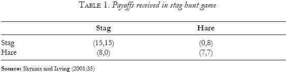
The game has two strategies that result in Nash equilibria: each hunter can hunt a stag and each hunter can hunt a hare. The equilibrium achieved when the two hunters go after a stag is the Pareto optimal, since there is no other game in which one of them improves his situation without negatively affecting the others.
Under the scheme described, the cooperation strategy guarantees the greatest payoffs, which represent the greatest level of well–being that players can obtain. Nevertheless, given the payoff structure, non–cooperation strategies are possible, and will lead to a loss in welfare.
In games with a single move and with simple strategies, both equilibria are possible. When more moves are allowed and some assumptions are changed, the results change. Zollman (2005) incorporates communication systems and eliminates the non–cooperation result. Macy and Flache (2002) analyze the prisoner dilemma, the chicken game and the hunter game, and introduce a learning element, indicating that in the latter game, cooperation is obtained more quickly than in the other two games.
The model can be applied to the case of surface waters if we consider that cooperation can emerge with the use of mechanisms that assure the best supply of water for both countries, whether by building and maintaining infrastructure, through cooperation for making better use of water or through financial assistance. Non–cooperation is manifested when each country appropriates all the water it can before it reaches its neighbor.
A possible cooperation strategy for the specific case of the region regulated by the Convention of 1906 would oblige Mexico to finance infrastructure in the United States for the appropriation of water in Mexico. This would reduce costs on the US side, and would permit inhabitants on the Mexican side to obtain greater volumes of water for various activities, thereby improving the level of welfare in the region. The payoffs for inhabitants of Mexico might not change if the expenditures made were equal to the profits generated by the water received. On the US side, however, a reduction in costs for supplying water would increase the payoffs received. Cooperation would mean an improvement in the non–cooperation arrangement, at least for one of the agents, maintaining the payoffs for the other at least at the same level, which increases efficiency and welfare from an economic point of view.
This type of arrangement has emerged in Mexico's northern border region, in places where clear regulations on water distribution are lacking. The case of the cities of Nogales in Mexico and Nogales in the United States is an example of this. A water treatment plant was built for taking care of wastewater from both populations, supplying surface water and helping to recharge underground water sources in Arizona (Dougman and García–Acevedo, 2005:263–269). The experience of cooperation in water management in the Mexico–US border region has been observed where there are sister cities and where communication is easier, in regions falling outside the existing treaties and where the main objective is to create urban infrastructure (Brown, 2001).
The model presents a simplification of the problem, since welfare in the region does not depend exclusively on the water distributed, but rather, there are other factors to consider. The policies followed by institutions in supplying water to users do not allow for the costs of providing this resource to be reflected in the tariff systems, and what is true is that the distribution of resources responds more to political factors than to economic factors.
The Convention of 1906 that granted sovereignty to the United States over the waters before Fort Quitman cancelled the possibility of cooperative agreements, since the transfer of water would represent a loss of sovereignty for the country that gave up the resource. Furthermore, because of the Convention, the states of Texas, Colorado and New Mexico developed agreements for the distribution of surface waters. Changes in these agreements would have high costs that would prevent any proposal along these lines. In this situation the existing strategy is one of non–cooperation, which is not optimal from an economic point of view. In the case in which evidence is found that suggests this is the prevailing strategy, it can be stated that existing institutions are moving away from economic efficiency.
This evidence can be found in the case in which the United States appropriates surface water, leaving only what is necessary to comply with the Convention of 1906. While the exact amount of water for Mexico is indicated, it is not actually the lowest point in the water transfers carried out by the United States, since they can be lower if there are extraordinary droughts or damages to the country's infrastructure.
To analyze this possibility, we will use water flow series in cubic meters per second (m3/sec) measured daily in El Paso, Texas from November 1889 to December 2005, and in Fort Quitman from January 1923 to December 2005. This information is available on the US Section of the IBWC (2006).
It can be maintained that the United States is using the strategy described if the El Paso series converges to a value equal to or less than the necessary level for fulfilling its commitments to Mexico. The series presents various problems before 1919. Specifically, there are years in which measurements were not taken, and some of the data with a value of zero does not correspond to what was observed in the same months during other years. This may be the result of possible deviations taking place upstream, the potential cause of conflicts between the two countries.4 Therefore, for statistical analysis purposes, the data prior to 1897 should be discarded, and it should be completed with another series. However, the original series will be described since it allows for observing peaks in the water flows.
The maximum value observed in the series is 669 m3/sec on June 14, 1905. Prior to that date, three important peaks were observed: one in 1891, another in 1897 and another in 1903. All of the peaks were above 450 m3/sec. After the maximum peak, another is observed, which is above 450 m3/sec in 1912 (see Diagram 2).
This information makes it possible to identify that there were flows above 450 m3/sec with a period of about six to seven years, in addition to the annual maximums that occurred between the months of May and July. The annual peaks were not under 100 cubic meters per year, with the exception of the years in which measurements marked zero. Up until 1909 it was possible to observe a relatively stable behavior of the peaks, with a period during which there was an important reduction in the peaks.
The amounts and dates of water delivery were scheduled in the 1906 Convention, and it was agreed that these deliveries would begin as soon as the construction of a dam near Eagle, New Mexico was completed. The last peak in the water flow above 450 cubic meters took place in 1912, and after that date one can see that the peaks tended to diminish, and levels such as those prior to 1912 were not observed again. After the Convention was ratified through the 1944 Treaty, the levels of the peaks were not above 170 m3/sec, and the peaks observed since 1959 have not been above 120 m3/sec.
If we look exclusively at the annual peaks in the water flows, we can see an increasingly greater appropriation of water by the United States, precisely after the conditions were created for the distribution of water in line with the Convention of 1906. According to the stag hunter game, there is evidence of a non–cooperation strategy. The Convention of 1906 put an end to the peaks, and assured a more uniform distribution of the water in line with scheduled deliveries. In the daily measurements of water flows, it is possible to observe greater distribution of water over time (Diagram 3).
At the beginning of the period we can observe major flows concentrated erratically on some days. From the time the Agreement went into effect, the distribution of flows over time is more uniform. This brought two benefits: it diminished the possibility of flooding and facilitated planning for water appropriation. The data demonstrate that these flows tend to stabilize, which can also serve as proof of the strategy used by the United States to appropriate the resource.
When we look at the daily data, it is difficult to manage the information and to clearly observe the amount of water delivered by the United States annually. The average flows in cubic metros per second for a period of a year, however, allow for estimating the amount of water delivered annually—the greater the average, the greater the amount of water delivered. It is estimated that in order to meet the requirement of delivering 74 Mm3 annually, an average flow of approximately 14 cubic meters per second is necessary. However, in the extraordinary circumstances stipulated in the Convention, lower averages are permitted.
The annual averages show a tendency to diminish beginning in 1912, with a peak in 1942, and stabilizing after 1956. Then, there is a slight tendency to increase beginning in 1986 when there is another peak (Diagram 4). To verify that the United States has a non–cooperation strategy and tends to keep the most water possible, the series must demonstrate: a) a tendency toward diminishing over time, and b) structural changes at the beginning and at the end of the series.
This verification was based on the time series analysis technique developed by Box and Jenkins, and used by Guerrero (1991). If we call / the average flow observed during year i, the first transformation used was 1/li. ; however the models found did not comply with the verification of assumptions. The next step was to use the transformation log (li), and the results for self–correlation and partial self–correlation functions were obtained.
It was determined that it is not necessary to apply differentiation operators to the series in order to make it stationary, and it was demonstrated that the series tends to stabilize at a certain level. Based on these functions it is possible to build autoregressive models of order 1 AR(1) or a combination of moving averages and autoregressive models of order 1, 1 ARMA (1,1). An AR(1) model was used with a constant that fulfilled most of the fundamental assumptions in an ARMA model:
ie= 2.78+0.57 let+1
where
let= logarithm base 10 of the flows observed in El Paso during year t.
The value of the estimator for the autoregressive part indicates convergence up to a value of 2.78, and a process of adaptation to existing conditions is observed.
In order to establish structural change, the original series was divided into two periods: from 1898 to 1955 and from 1956 to 2005; 1956 was selected as the point for dividing the series, since a stabilizing effect was observed beginning in that year. Since series with less variance are not used, the best models are not guaranteed, however we find that it is easier to describe behavior. The models obtained are the following:
For the period from 1898 to 1955 êpt = 24.80140012 + 0.3303601955 ept+l
For the period from 1956 to 2005 êpt = 14.91857786 + 0.6282485871 ept+l
where
ept+1 = the flow measured at El Paso during year t.
In the first model we can observe greater volume in the average flow and quicker stationalization. In the second model the series becomes stationalized at a value close to what was estimated as necessary for fulfilling the commitments stipulated in the Convention.
We have thus verified that there is a tendency toward the flow diminishing and stabilizing at a certain level, and that there is a structural change in the series. This may be due to the strategy identified; however it may also be due to factors related to population and economic growth. If the United States were seeking to appropriate as much water as possible, the two factors just mentioned would reinforce this strategy, and the latter would be verified in the consumption of water between El Paso and Fort Quitman.
Since the Convention went into effect, appropriators after El Paso have been obliged to adapt their consumption patterns to the amounts of water delivered, depending on the rainfall in the region. If we assume constant precipitation, the difference between the flow measured at El Paso and the flow measured at Fort Quitman would be a constant. In the case of favorable climatic conditions, consumption could be decreased, and consequently the difference would diminish. In the case of unfavorable conditions in the region, consumption of the water delivered would increase and so would the difference between the flows. Thus, if none of the exceptions contemplated in the Convention occurred, it would become evident that the difference is a constant, together with variations that should have a mean of zero, normal behavior and constant variance.
If the deliveries from the United States are the only source of water flows, the flow measured at Fort Quitman would be close to zero, since the appropriators in the region would use all the water available. If there is a new source of surface water, an increase in the flow at Fort Quitman would become apparent, as well as a decrease in the difference between the flows at El Paso and Fort Quitman. In the case of the exceptions stipulated in the Convention, the flow at Fort Quitman would be zero and the difference between flows would diminish, since the appropriators in the region would have a smaller amount of water.
The records at Fort Quitman begin in 1923 and end in 2005, and demonstrate that the tendencies in the flows at that location are similar to the flows at El Paso (Diagram 5). At the beginning of the series, we can observe a decrease in the flow, reaching practically zero in 1951. This tendency was maintained, with some ups and downs, until 1977, when there was an increase in the flow, and then a peak in 1986. The difference between the flows at El Paso and Fort Quitman indicates the following results: an average of 10.83 cubic meters per second, with a maximum of 20.27 and a minimum of 2 (Diagram 6). The average indicates less than strict compliance with the Convention, and the minimum suggests the exceptions stipulated in the Convention have been applied, specifically extraordinary drought conditions. The maximum can be considered atypical, since it occurred when there was a peak in the flow at El Paso. Apparently, the inhabitants there do not have the capacity to appropriate this amount of water.
The behavior in the series indicates two points in time: 1) from 1923 to 1950 there was greater compliance with US obligations. However 2) beginning in 1951, new conditions presented themselves, with greater variance in the series and a lower average corresponding to the differences between the two flows measured. The series indicates autoregressive behavior in the following manner:
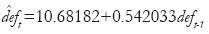
where
deft = the difference between the flow measured at El Paso and the flow measured at Fort Quitman during the year t.
The original series was used to determine the value where the series converges, although it was not the series that presented the least variance. If the model with data up until 1950 is considered, the autoregressive component disappears and a mean of 13.44 is obtained in the difference between the two flows, with a mean of zero in errors. In this model variance can be considered to be constant, although there was a large error in one year.
CONCLUSIONS
The results obtained indicate that the United States continues its strategy of appropriating as much water as possible. Up until 1950 US behavior was the closest to strict compliance with the Convention, however between 1950 and 1977 there are situations reflecting the use of exceptions for non–compliance with water deliveries. According to Wurbs (2004), the clauses of exception have been used in at least a third of the years since 1951.
After that period, the United States increased the water flow, but appropriators had apparently become accustomed to smaller amounts of water, and did not make use of all the resources available. The increase in the flow at Fort Quitman can possibly be explained by the introduction of new sources of surface water, such as those from the urban system in El Paso, Texas and Ciudad Juarez.
The conflicts between Mexico and the United States over the use of surface water created the need to reach an agreement on cooperation and led to the establishment of the Convention of 1906 for this part of the border. Nevertheless, this scheme cancels out any other arrangement from being made for the distribution of water or other cooperative solutions. And this allows the United States to keep as much water as possible for itself, claiming the use of exceptions, such as extraordinary drought, which in fact has never been defined.
The low precipitation that leads to low water availability, and the economic and population growth in the region, make it necessary to design policies requiring cooperation to be integrated into the region's surface water management. Experience in the border region demonstrates that participation by the governments of both countries at the different levels leads to better use of water. This has removed obstacles from the region's growth and can pave the way for an increase in welfare on both sides of the border.
The way that water has been appropriated means that low water availability is transformed into a permanent drought, accompanied by growing tension in the region in the urgency to obtain this resource.
It is necessary to reformulate the institutions currently operating, since the way in which they were created has not allowed for the emergence of cooperation and has limited the potential solutions for a type of water management that can guarantee the greatest possible level of welfare. Societies must urge states to move from a logic of relative gain to one of absolute gain, in order to improve the region's institutional framework and potential for development.
REFERENCES
Antal, Edit, 2004, Cambio climático: desacuerdo entre Estados Unidos y Europa, México, Plaza y Valdés. [ Links ]
Arias, Héctor M., 2000, "International Groundwaters: The Upper San Pedro River Basin Case. (The La Paz Symposium on Transboundary Groundwater Management on the U.S.–Mexico Border)", Natural Resources Journal, vol. 40, núm 2, pp. 191–221. [ Links ]
Barajas, Ismael A., 1999, "Interregional Transfer of Water in Northeastern Mexico: the Dispute over El Cuchillo. (Coping with Scarcity in the Rio Grande/Rio Bravo Drainage Basin: Lessons to Be Learned from the Droughts of 19931996)", Natural Resources Journal, vol. 39, núm. 1, pp. 65–98. [ Links ]
Benvenisti, Eyal, 2002, Sharing Freshwater, Nueva York, Cambridge University Press. [ Links ]
Brown, Christopher P., and Stephen Mumme, 2000, "Applied and Theorical Aspect of Binational Watershed Councils (Consejos de Cuenca) in the U.S. Mexico Borderland", Natural Resources Journal, vol. 40, núm 3, pp. 895–929. [ Links ]
Brown Parra, Laura, 2001, "El Banco de Desarrollo de América del Norte: avances y retos", Comercio Exterior, vol. 51, núm 6, pp. 3–16. [ Links ]
Buck, Susan, 1998, Global Commons: An Introduction, Island Press. [ Links ]
Chávez, Octavio E., 1999, "The 1994–1995 Drought, what did we Learn from it? The Mexican Perspective. (Coping with Scarcity in the Rio Grande/Rio Bravo Drainage Basin: Lessons to Be Learned from the Droughts of 1993–1996)", Natural Resources Journal, vol. 39, núm 1, pp. 35–60. [ Links ]
Chávez, Octavio E., 2000, "Mining of Internationally Shared Aquifers: The El Paso–Juarez Case. (The La Paz Symposium on Transboundary Groundwater Management on the U.S.–Mexico Border)", Natural Resources Journal, vol. 40, núm 2, pp. 237–260. [ Links ]
Comisión Nacional del Agua (CNA), 2003, Programa Hidráulico Regional 2002–2006. Río Bravo. Región VI, México, Comisión Nacional del Agua. [ Links ]
Convention for the Equitable Distribution of the Waters of the Rio Grande, 1906, May 21, in <http://www.ibwc.state.gov/Files/1906Conv.pdf>, consulted on December 14, 2007. [ Links ]
DeBuys, William, 2001, "Navigating the River of our Future: The Rio Poco Grande", Natural Resources Journal, vol. 41, núm. 2, pp. 265–281. [ Links ]
Durant, Robert F., and Michelle D. Holmes, 1985, "Thou shalt not covet thy Neighbor's Water: The Rio Grande Basin Regulatory Experience", Public Administration Review, vol. 45, p. 6. [ Links ]
Doughman, Pamela and María García–Acevedo, 2005, "Visiones contrastantes del agua y su impacto en el manejo del agua, la equidad social y la cooperación transfronteriza. El manejo de los recursos acuíferos en la frontera México–Estados Unidos"; en Alfonso Andrés Cortez Lara, Scott Whiteford y Manuel Chávez Márquez, coords., Seguridad,, aguay desarrollo. El futuro de lafrontera México–Estados Unidos, Tijuana, B.C., El Colegio de la Frontera Norte/Michigan State University, pp. 253–288. [ Links ]
Gantz, David A., 1996, "The North American Development Bank and the Border Environment Cooperation Commission: A New Approach to Pollution Abatement along the United States–Mexican Border. (Symposium: Free Trade Areas: The Challenge and Promise of Fair vs. Free Trade)", Law and Policy in International Business, 27, pp.1027–56. [ Links ]
Guerrero, Víctor M., 1991, Análisis estadístico de series de tiempo económicas, México, Universidad Autónoma Metropolitana. [ Links ]
Hume, Bill, 1999, "Big river, big issues. (Coping with Scarcity in the Rio Grande/ Rio Bravo Drainage Basin: Lessons to Be Learned from the Droughts of 1993–1996)", Natural Resources Journal, vol. 39, núm. 1, pp. 17–26. [ Links ]
Hume, Bill, 2000, "Water in the U.S.–Mexico Border Area. (The La Paz Symposium on Transboundary Groundwater Management on the U.S.–Mexico Border)", Natural Resources Journal, vol. 40, núm. 2, pp. 189–97. [ Links ]
Hurlburt, David, 2001, "The Good, the Bad, and the Arid. (Rio Grande Management, United States–Mexico)", Forum for Applied Research and Public Policy, vol. 16, núm. 1, p. 9. [ Links ]
International Boundary and Water Commission (IBWC), 2006, in <http://www.ibwc.state.gov/wad/histflo1.htm>, consulted on May 1, 2006. [ Links ]
IBWC, 2007, Transboundary Aquifers and Binational Ground Water Database, Rio Grande Historical Mean Daily Discharge Data, in <http://www.ibwc.gov/Water_Data/histflo1.htm>, consulted on November 5, 2007. [ Links ]
IBWC, 2008, project maps, in <http://gisdata.usgs.gov/website/IBWC/viewer.php>, consulted on July 21, 2008. [ Links ]
Ingram, Helen, 1999, "Lessons learned and recommendations for coping with Future Scarcity. (Coping with Scarcity in the Rio Grande/Rio Bravo Drainage Basin: Lessons to Be Learned from the Droughts of 1993–1996)", Natural Resources Journal, vol. 39, núm. 1, pp. 179–188. [ Links ]
Ingram, Helen and David R. White, 1993, "International Boundary and Water Commission: an Institutional Mismatch for Resolving Transboundary Water Problems", Natural Resources Journal, vol. 33, núm. 1, pp. 153–200. [ Links ]
Johnstone, Nick, 1995, "International Trade, Transfrontier Pollution, and Environmental Cooperation: A Case Study of the Mexican–American Border Region", Natural Resources Journal, vol. 35, núm. 1, pp. 33–62. [ Links ]
Jones, Celina A., 2002, "The Administration of the Middle Rio Grande Basin: 19562002. (New Mexico)", Natural Resources Journal, vol. 42, núm. 4, pp. 939–68. [ Links ]
Martinez, Eluid, 1999, "Coping with Water Scarcity on the Rio Grande/Rio Bravo. (Coping with Scarcity in the Rio Grande/Rio Bravo Drainage Basin: Lessons to Be Learned from the Droughts of 1993–1996)", Natural Resources Journal, vol. 39, núm. 1, pp. 117–119. [ Links ]
Mumme, Stephen P., 1999, "Managing Acute Water Scarcity on the U.S–Mexico Border: Institutional Issues Raised by 1990's Drought (Coping with Scarcity in the Rio Grande/Rio Bravo Drainage Basin: Lesson to be Learned from the Droughts of 1993–1996)", Natural Resources Journal, vol. 39, núm. 1, pp. 93–132. [ Links ]
Mumme, Stephen P., 2003, "Revising the 1994 Water Treaty: Reflections on the Rio Grande Drought Crises and other Matters", Journal of the Southwest, vol. 45, núm. 4, pp. 649–671. [ Links ]
Mumme, Stephen et al., 1993, "Innovation and Reform in Transboundary Resource Management: Critical Look at the International Boundary and Water Commission, United States and Mexico", Natural Resources Journal, vol. 33, núm. 1, pp. 93–132. [ Links ]
Macy, Michael W. and Andreas Flache, 2002, "Learning Dynamics in Social Dilemmas", PNAS, vol. 99, núm. 3, pp. 7229–7236. [ Links ]
North, Douglas C., 1993, Instituciones, cambio institucional y desempeño económico, México, Fondo de Cultura Económica. [ Links ]
Ostrom, Elinor, Roy Gardner, and James Walker, 1994, Rules, Games, & Commons–Pool Resources, The University of Michigan Press. [ Links ]
Schoik, Rick V et al, 2004, "Barriers and Bridges: Managing Water in the U.S.Mexican Border Region", Environment, vol. 46, núm. 1, pp. 26–42. [ Links ]
Secretaría del Medio Ambiente y Recursos Naturales (Semanart), "National Waters Act of 2004", Diario Oficial de la Federación, 29 de abril de 2004, en <http://www.diputados.gob.mx/LeyesBiblio/ref/lan/LAN_ref01_29abr04.doc>, consulted on March 18, 2008. [ Links ]
Skyrms, Brian and U. C. Irvine, 2001, "The Stag Hunt", Proceedings and Addresses of the American Philosophical Association, vol. 75, núm. 2, noviembre, pp. 31–41. [ Links ]
Solanes, Miguel and Andrei Jouravlev, 2005, Integrando economía, legislación y administración en la gestión del agua y sus servicios en América Latina y el Caribe, Santiago de Chile, División de Medio Ambiente y Asentamientos Humanos, Serie Recursos Humanos e Infraestructura, CEPAL. [ Links ]
Szekely, Alberto and Lucio Cabrera, 1993, "Emerging Boundary Environmental Challenges and Institutional Issues: Mexico and the United States", Natural Resources Journal, vol. 33, núm. 1, pp. 1–12. [ Links ]
Toledo, Alejandro, 2002, "El agua en México y el mundo", Gaceta Ecológica, núm. 64, julio–septiembre, pp. 9–18. [ Links ]
Utton, Albert E., 1999, "Coping with Drought on an International River under Stress: The Case of the Rio Grande/Rio Bravo.(Coping with Scarcity in the Rio Grande/Rio Bravo Drainage Basin: Lessons to Be Learned from the Droughts of 1993–1996)", Natural Resources Journal, vol. 39, núm. 1, pp. 27–34. [ Links ]
West, Krista, 2003, "Restoring the Rio: Efforts to keep the Rio Grande filled with Water", Scientific American, vol. 289, núm. 5, pp. 26–28. [ Links ]
Wurbs, Ralph, 2004, "Water Allocation Systems in Texas", Water Resource Development, vol. 20, núm. 2, pp. 229–242. [ Links ]
Yoskowitz, David W, 1999, "Spot Market for Water along the Texas Rio Grande: Opportunities for Water Management", Natural Resources Journal, vol. 39, núm. 2, pp. 345–355. [ Links ]
Zollman, Kevin J. S., 2005, "Talking to Neighbors: The Evolution of Regional Meaning", Philosophy of Science, núm. 72, february, pp. 69–85. [ Links ]
1 The salt can be removed from ocean water in coastal regions, however this is an expensive process that is used only when there is no other water source.
2 There is also a third agent: the producer who constructs repairs or carries out actions to assure the maintenance of the system of resources in the long term. This agent may be the same as the supplier.
3 Fort Quitman was a military installation during the 19th century, and is currently abandoned. It is located 129 kilometers from El Paso, Texas, down the Rio Grande.
4 One of the objectives mentioned in the Convention of 1906 is to "remove all causes of controversy" between the two countries.

