


 nueva página del texto (beta)
 Inglés (pdf)
 Artículo en XML
 Referencias del artículo
 Enviar artículo por email
 Citado por SciELO
  Similares en
SciELO
Similares en
SciELO 
 Permalink
Introduction
El Castillo pyramid is located in the archaeological zone of Chichen Itza (Figure 1A), in the southeastern lowlands of Mexico, within the Yucatan Peninsula (Figure 1B). This magnificent building is probably the most important edifice within the archaeological site (Figure 1C).
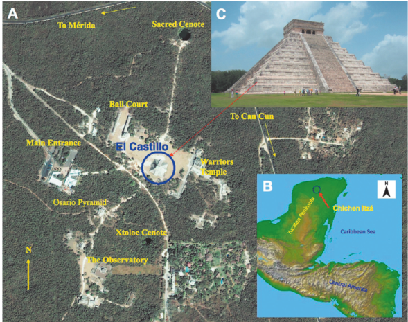
Figure 1 Image from the archaeological site of Chichen Itza taken by the IKONOS satellite in 2001 (A). The archaeological site is found towards the northern portion of the Yucatan Peninsula (B). The location of El Castillo pyramid (blue circle) at the center of this view and the nowadays structure are shown (C).
Traditionally, archaeologists have considered that this Mayan city was occupied by different ethnic groups in the time, moving from an “Older Chichén Itza” to a “New Chichen Itza”. Different constructive styles are found in the region, the Puuc would be developed in Chichen Itza towards the Late Classic and Terminal Classic periods (600-900 AD) and can be seen towards the southern part of the site. On the other hand, the architectural style called Maya-Toltec is related to the influence of groups coming from Central Mexico around 900 AD. Recent studies, based on petrographic analyzes and dating by the Thermoluminescence technique of ceramic samples, predominant in the region (Chung Seu, 2000) and relative dating (Schmidt, 1998; Osorio, 2004; Pérez Heredia, 2004), established the starting cultural sequence as:
• Episode I, 550-800 AD, arrival of the first ‘pure’ Mayas, reflecting in their materials a remarkable southern tradition of the Yucatan peninsula. This episode could be correlated with the Yabnal/Motul ceramic complex, related to the beginning of the urban development of the site.
• Episode II, 750-800 AD, the main period of development and expansion of Chichen Itza, maintaining a close relationship with the south and west of the peninsula (Tabasco and Chiapas). This episode could be correlated with the complexes Cehpech (associated with the “Puuc” style buildings) and Sotuta (associated directly with the maximum splendor of Chichen Itza and corresponding to the architecture called “Maya-Toltec”).
• Episode III, 1100-1300 AD, decay and arrival of another foreign group with cultural features from Central Mexico. This episode could be correlated with the Hocabá complex, recovered mainly in contexts of reoccupation of the site.
The two last constructive phases of the pyramid, the one we see nowadays and substructure 1, correspond to Episode II.
The edification of the actual pyramid is dated approximately between the years 900 and 1000 AD, while the first substructure, unveiled during the 1930’s, is dated around 850 AD. An edifice corresponding to Episode I has been a controversial topic among the Mayan specialists.
Therefore, the present research is devoted to explore the interior of El Castillo pyramid employing a non-conventional and non-invasive technology able to ‘illuminate’ the pyramid´s interior in order to define the constructive phases inside this pyramid.
Methodology
Sometimes, spatial conditions of the surveyed area do not allow deployment of conventional three-dimensional electric resistivity tomography (ERT-3D) geometries (Tejero et al., 2015). Such constraints are imposed by natural or anthropogenic ‘obstacles’, which are often the targets of the proposed survey (Trogu et al., 2011; Argote et al., 2013). Alternative arrays have to be improved to solve this problem. Chávez et al. (2015A), and Tejero et al. (2015) suggested novel geometries to characterize the subsoil beneath archaeological and urban zones. In this work, the ‘L’, ‘Corner’, and ‘Minimum Coupling’ arrays were employed, adding the so called ‘Gradient’ array. These non-conventional geometries attempted to ‘see’ the pyramid’s interior (Figure 2), where two electric arrays in ‘L’ and four ‘Corner’ arrays define a squared geometry that encloses the structure of interest. Such arrays are described in detail by Argote et al. (2013) and Tejero et al. (2015). They have also demonstrated that different settings developed for ERT-2D can be employed to identify different bodies present in the subsurface. Based in these 2D electric arrays, Dahlin and Zhou (2004) analyzed the possibilities of 10 different arrays as well as their resolution for different targets. Szalai et al. (2015) investigated different distances between electrodes for the Wenner-Gamma array and showed that small resistive bodies can be detected. Finally, Barker (1989) focused his investigation on the penetration depth for different Wenner arrays (alfa, beta, gamma) in comparison with quadrupole sets.
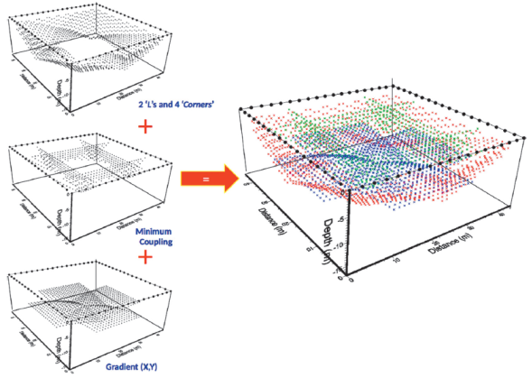
Figure 2 TRE-3D arrays employed to survey either El Castillo subsoil and its interior. Two ‘L’s, four ‘Corners’, Minimum Coupling (MC) and the Gradient arrays (left) were employed to cover the subsurface of each pyramid’s body (right). Observed resistivities for each array are shown as small black dots (left). The total number of observations are depicted in colored dots (right). Electrodes position are shown as black circles forming the squared geometry.
In the present investigation, the WennerSchlumberger array was selected to construct the ‘L’ array, since measured readings are less noisy, mainly towards the center of the square than those performed with dipolar settings. ‘Gradient’ and ‘Minimum Coupling’ arrays were employed to better resolve the inner and perimeter portions of the squared geometry.
The ERT-3D data were acquired employing a Syscal-Pro Resistivimeter (IRIS Instruments, France) with 48 channels with a switch box that allowed the addition of 48 additional electrodes. Distribution of the apparent resistivity observations at depth were computed with the software Electre-Pro (IRIS Instruments, 2010). The attribution points of each observed data were calculated employing an in-house software. (Tejero et al., 2015) describe in detail the procedure to compute the coordinates of the attribution points. (X, Y) coordinates are calculated employing the same process followed for two dimensional arrays. For the Z coordinate or depth of investigation, the depth of the median was considered where 50% of the current flows both above and below that point. Such calculation is based on the concept of the sensitivity function for specific arrays provided by Edwards (1977) and Barker (1989).
The inversion and modelling processes were carried out with the commercial software ERTLab-64 (Geoastier-Geophysics, 2012). Data inversion is mostly based on the method described by Constable et al. (1987), where an objective weighted function is minimized in the sense of a root mean square method (Tejero et al., 2002).
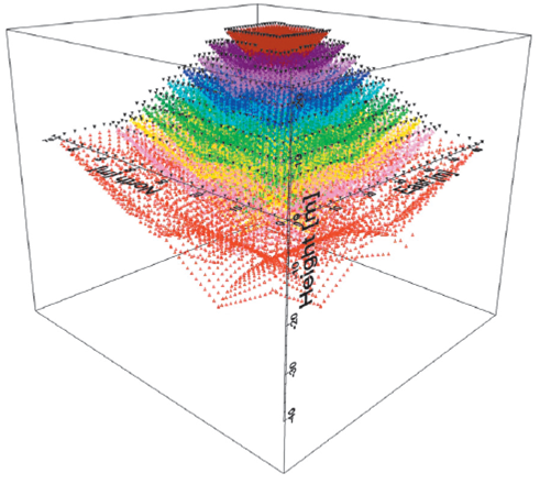
El Castillo pyramid consists of 9 levels (pyramidal bodies), plus a tenth level that corresponds to the ground level (Figure 3A). Flat electrodes were placed on each body of the pyramid, starting at the top and finishing at the bottom, as shown in Figure 3B. Special gel was applied on the contact area of each electrode to assure good electrical coupling between the plate and the surface (made of stucco) of each level. It has to be mentioned that a careful control on the position (x, y, z) of each electrode was done by employing a double-frequency GPS, consisting of a base and a portable unit. This last one is located on each electrode position and referenced with the base station.

Figure 3 Schematic depiction of the dimensions of El Castillo pyramid and the 10 bodies that make up this preHispanic building (A). The position of the electrodes deployed on each body is shown (B). Each electrode was deployed in the middle of each body.
Data were acquired for each body employing the electrical arrays already mentioned. Each data obtained was corrected for positioning and topographic effects. Finally, 37,520 observations were measured (Figure 4, colored dots). However, 19,400 apparent resistivity observations could be processed and inverted by selecting the levels 10, 9, 5, 4, and 3, since the computation capabilities available were not sufficient to compute the whole set of data. On the other hand, these bodies were inverted in order to obtain a more detailed view of the cavity beneath the pyramid, and to better resolve possible structures within El Castillo on those levels. Obviously, we will lose resolution at the top of the edifice.
Interpretation
The inverted model depicts most of the infill material employed by settlers to build the pyramid, with resistivity values around 700 Ohm-m (in green). Such materials are mostly limestone. Saturated areas (<60 Ohm-m) are depicted in blue (Figure 5A). It is important to mention that, although the apparent resistivity values measured in blocks 8, 7, 6, 2 and 1 were not inverted, their calculated topographic values in all observation levels were introduced during the inversion process for each electrode.
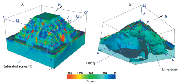
Figure 5 Side view of the southern and western faces (A) of El Castillo pyramid are depicted. In red the effects of the stairs are shown and in blue possible saturated zones. The spectacular geometry of the cavity partially filled with water is clearly seen (B), observing the model from its bottom part. Electrodes position are shown as red dots.
The inverted resistivity model viewed from its lower portion (Figure 5B) depicts the geometry of the cavity beneath El Castillo pyramid discovered in 2015 (Chavez et al., 2015B). Such feature is clearly revealed, with resistivity values ranging between 20 and 80 Ohm-m. As Chavez et al. (2015 B) pointed out, it is very likely that this feature is partially filled with water.
In the cross-section model (Figure 6), the X and Y directions at the central portion of the pyramid (crossing planes at X=36 m) are combined, from south to north (A) and east to west (B). The location of two resistive boundaries can be inferred. The yellow line outlines the substructure 1 discovered in 1934 (Erosa-Peniche, 1939). The white discontinuous line sketches the substructure 2 inferred by the geophysical data.
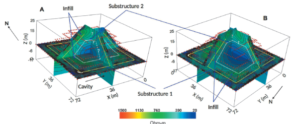
Figure 6 Detailed view of cross sections for X = 36 m and Y = 36 m and the plane Z=0 m at the base of the pyramid. Examining the resistivity gradients (values of 700 Ohm-m, approximately) for different directions in (south to north, A) and (east to west, B), it is possible to infer the location of substructure (1) (broken yellow line). Following the same process, substructure (2) can be sketched (broken white line). Notice that resistivity values for both substructures range between 80 Ohm-m (for substructure 1) and 40 to 20 Ohm-m (for substructure 2), indicating a high degree of saturation.
It is interesting to point out, that an important resistive gradient is observed that limits the structure of El Castillo pyramid and substructure (1), delimited by the dashed yellow line. The resistivity values in this portion are about 750 Ohm-m (green), probably related to fill material (limestone made as a mortar) employed to cover this older pyramid. Such an effect can be clearly observed on the horizontal slice, where an interesting resistivity gradient is found. A similar effect might be followed that makes possible to sketch the limits (dashed white line) of substructure (2). This is more evident in the horizontal slice, where again a slight resistive gradient (~750 Ohm-m, in green) can be observed.
The upper portions of both inner structures cannot be clearly defined (question marks), even if it is well known that at the top of substructure (1), a temple is found (a jaguarshaped throne and a Chac-Mol sculpture were found in it). Unfortunately, at this moment theupper levels have not been yet interpreted, then the resistivity model is unable to detect that structure.
It is important to mention that both inferred bodies have low resistivities, ranging between ~ 80 Ohm-m for substructure (1), and 40 to 20 Ohm-m for substructure (2), which could indicate a high degree of saturation (humidity) of the materials that constitute the interior of El Castillo pyramid. It is worth mentioning that the region where the site is settled has an annual rainfall ranging from 1000 to 1600 mm, therefore water might infiltrate the limestone rocks and soils saturating them.
Finally, a N-S ERT-2D profile was performed inside El Castillo pyramid and over its first substructure to confirm the results obtained with the ERT-3D study concerning the presence of a second substructure (Figure 7). A total of 67 electrodes were installed along the tunnel, staircase and temple. The separation between each flat electrode was about 1 m. The data were corrected by topographic effects, electrode positioning, and noisy data.

Figure 7 Geo-electric (ERT-2D) profile taken in a tunnel inside El Castillo pyramid, and over the stairway and temple of substructure (1) (Erosa-Peniche, 1939). The dotted lines show the boundary of substructure (2) covered by the infill material, on which the first one (dashed line) was built.
The infill material, over which substructure (1) is supported, is shown in green tones (values between 100 and 200 Ohm-m). Subsequently, a series of higher resistivity anomalies can be observed (between 350 and almost 1000 Ohm-m), which present a very particular behavior pattern. These anomalies seemed to delimit a resistivity contrast between two different materials (broken line). These could correspond to a coating of limestone blocks of a second substructure (substructure 2).
Towards the upper portion of the profile, at the top, two very interesting resistive anomalies can be observed. The first one corresponds to a tilted highly resistive body (> 2000 Ohm-m). This structure could be associated either to a poorly consolidated material, perhaps limestone material used to cover substructure (2) during the construction of substructure (1), or to a portion of a partially destroyed tall roof of the oldest temple that probably possessed some special decoration (all made with limestone rocks).
Commonly, Mayan temples of the Late Classic period had tall and wide rooftops, highly ornamented with large masks and sculptures representing deities and other decorations as can be seen in Ek Balam, an archaeological site located 50 km northeast of Chichén Itzá. This fact could explain the wide extension of the anomaly. This body possesses an average height of 12 m at X = 26 m, approximately.
Furthermore, below this high-resistivity anomaly, a medium-resistivity features (values ranging from 100 to 300 Ohm-m)can be seen forming a rectangular space. The geometry and the differences in the resistivity values could be reflecting the presence of a preserved temple´s chamber cover with infill material. When archaeologists in 1935 excavated and opened the main chambers of the temple corresponding to substructure (1), they were intact, only covered with infill material (Erosa Peniche, 1939). The same case could occur for the temple located on top of substructure (2).
The low-resistivity (<25 Ohm-m) anomalies located just below the temple of substructure (1) indicate areas of high humidity. It is important to mention that inside the temple of substructure (1) a high degree of moisture occurs, which infiltrates from the outside and is deposited in the floor, filling the pores of the stucco that covers it. This could be the cause of the water saturation at this point.
Conclusions
The capability of the three-dimensional Electrical Resistivity Tomography (ERT-3D) method applied to ‘illuminate’ El Castillo pyramid was demonstrated in this investigation. Mainly, because the geophysical method used is not invasive and does not disturb the historical context of the archaeological site. This type of experiment has been the first of its kind to be carried out in pre-Hispanic buildings, employing novel electrical arrays, then:
1. It was possible to design appropriate novel geo-electric arrays to ‘illuminate’ the pyramid’s interior. The presence of substructure (1) is very well defined and the ERT- 3D results suggest the presence of a second one (substructure 2), supported by the interpretation done in the ERT-2D profile.
2. The evidence provided about the existence of substructure (2) within El Castillo, suggests that at least three different constructive phases took place in the archaeological site of Chichen Itza.
3. As soon as the inversion process for the 10 levels will be completed, a better resolution will be reached for the upper portions of the resistivity model. More detailed characteristics of substructure (2) are then expected.

