


 nueva página del texto (beta)
 Inglés (pdf)
 Artículo en XML
 Referencias del artículo
 Enviar artículo por email
 Citado por SciELO
  Similares en
SciELO
Similares en
SciELO 
 Permalink
Introduction
A primary function of the U.S. Fish and Wildlife Service (USFWS) has been the development and maintenance of refuges that provide protected habitat for the conservation of fish and wildlife. Historically, individual refuges were established for a variety of specific management purposes but were not guided by a uniform mission statement (Schroeder 2008). The National Wildlife Refuge System Administration Act of 1966 (16 U.S. Code § 668dd) formally established the USFWS refuge system. The mission of the wildlife refuge system was clarified under the National Wildlife Refuge System Improvement Act of 1997 (Public Law 105-57. 111 Statute 1252) as the “conservation, management, and where appropriate, restoration of the fish, wildlife, and plant resources and their habitats”. Under this comprehensive mandate, the Fish and Wildlife Service is concerned with assessing the effects of refuge management practices on non-target wildlife.
Fish Springs National Wildlife Refuge (Figure 1) was established in 1959 specifically to create habitat for migratory waterfowl in an area of natural desert wetland in western Utah (U.S. Fish and Wildlife Service 2004). Between May 1961 and October 1964, the natural discharge from a series of existing geothermal springs was altered with the construction of dikes and canals resulting in a network of engineered wetland habitat managed through regulated flooding, prescribed burns, mowing, and herbicide treatments (U.S. Fish and Wildlife Service 2004).
Habitat manipulation for conservation and management purposes can have immediate impacts on the abundance and occurrence of small mammals (Zou et al. 1989; Mitchell et al. 1995; Fitzgerald et al. 2001). Because they are sensitive to changes in vegetation and microclimate and have short generation times and high reproductive potential, small mammals can be excellent indicators of landscape change and ecosystem health. However, species responses unfold over time through stages of development among management treatments that differentially shape the composition and structure of vegetation. Thus, the impacts reported in previous studies may only reflect short-term changes rather than long-term responses of small mammal populations and communities (Swihart and Slade 1990; Brady and Slade 2001; Fernández et al. 2021; Fuentes et al. 2020).
As an isolated wetland within the arid eastern Great Basin, Fish Springs provides important ecological services in supporting a range of biodiversity. As an area with a long and successful history of exclusive management directed toward one particular faunal group (birds), Fish Springs also provides an opportunity to study long-term effects of this management approach on other faunal groups. In this study, we use data from museum records and modern field surveys to examine how six decades of directed waterfowl management at Fish Springs has affected its mammal fauna.
Materials and methods
Study area and history. Fish Springs National Wildlife Refuge (hereafter “Fish Springs” or “refuge”) is located on the northeastern flank of the Fish Springs Range at the southern margin of the Great Salt Lake Desert in western Juab Co., Utah (Figure 1). The refuge encompasses 7,280 ha with elevations ranging from 1,305 m along the eastern boundary on the Fish Springs Flat to 1,450 m in the northeastern-most portion of the Fish Springs Range. A series of geothermal springs located along the eastern base of the Fish Spring Range have a combined annual discharge of approximately 32 million m3 (Gates and Kruer 1981). These springs support a marsh wetland with surrounding vegetated sand dunes on the west and south and desert playa to the north and east.
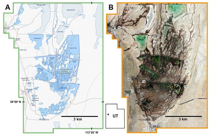
Figure 1 Fish Springs National Wildlife Refuge in western Utah (inset map). A) U.S. Geological Survey topographic map showing spring discharge and areas of open water in managed wetland (dark blue) and areas of managed meadow and seasonal playas (gray). B) Satellite image from Berkeley Mapper (Arctos) with trapping locations numbered as in Table 1.
Fish Springs is located within the Bonneville Basin, which defines the eastern-most portion of the Great Basin. The region was under water from about 26 Ka when Lake Bonneville began to fill (Grayson 2011) to about 11.4 Ka at the end of the Gilbert episode (Oviatt 2014) with the subsequent development of wetland habitat. Archaeological surveys of two Fish Springs cave sites indicate prehistoric occupancy by late Archaic peoples between 2.5 and 4.0 Ka based on radiocarbon dating of charcoal and associated archaic projectile points (Madsen 1982). Projectile points recovered from upper stratigraphic layers revealed occupation by post-Archaic people after 1800 BP.
Fish Springs is within the ancestral lands of the Goshute (Newe) people who were hunter-gatherers in this region until the early 1900s (USFWS 2004). The earliest documented occupation by Euro-Americans was in 1859 to 60 with the establishment of Pony Express and Overland Stage stations. In the 1890s, John J. Thomas established a cattle and horse ranch at Fish Springs, and in 1913, the Lincoln Highway was built to accommodate automobile travel (Joy 1916). The Fish Springs Livestock and Fur company was established in 1925 (USFWS 2004). These human activities involved direct exploitation of large game and other resources and direct habitat disturbance. In 1959, Fish Springs was purchased by the US Fish and Wildlife Service with subsequent major modifications to the marsh ecosystem as described above.
Habitats. The refuge includes five principal terrestrial habitats (Table 1) distinguished by vegetation and edaphic features (Robson and Rickart 2004; USFWS 2004; also see Bolen 1964; Emrick and Hill 1998).
Table 1 Small mammal (rodent and shrew) trapping data at sites in five major habitat types at Fish Springs National Wildlife Refuge, Juab County, Utah, USA. Data are from surveys conducted in 2002 and 2003 (UMNH records).
| Site number | Habitat type | Decimal latitude | Decimal longitude | Elev (m) | Total trap nights | Specimens collected | Animals released | Trap success (%) | |
|---|---|---|---|---|---|---|---|---|---|
| 1 | spring edge | 39.88758° | 113.41237° | 4,281 | 57 | 8 | 0 | 14.04 | |
| 10 | " | 39.90414° | 113.40073° | 4,281 | 62 | 14 | 0 | 22.58 | |
| 16 | " | 39.87831° | 113.37464° | 4,280 | 30 | 17 | 1 | 60.00 | |
| habitat totals | 149 | 39 | 1 | 26.85 | |||||
| 4 | marsh meadow | 39.88725° | 113.40827° | 4,305 | 112 | 1 | 0 | 0.89 | |
| 5 | " | 39.88758° | 113.41237° | 4,281 | 90 | 6 | 1 | 7.78 | |
| 14 | " | 39.84967° | 113.38392° | 4,301 | 30 | 3 | 0 | 10.00 | |
| 18 | " | 39.87877° | 113.37532° | 4,276 | 15 | 6 | 0 | 40.00 | |
| 22 | " | 39.85872° | 113.34547° | 4,296 | 10 | 1 | 0 | 10.00 | |
| habitat totals | 257 | 17 | 1 | 7.39 | |||||
| 7 | salt shrubland | 39.88449° | 113.41314° | 4,250 | 89 | 6 | 0 | 6.74 | |
| 19 | " | 39.87907° | 113.37540° | 4,278 | 30 | 1 | 3 | 13.33 | |
| 23 | " | 39.88207° | 113.36964° | 4,302 | 60 | 2 | 1 | 5.00 | |
| habitat totals | 179 | 9 | 4 | 7.26 | |||||
| 3 | sand dune | 39.82750° | 113.35964° | 4,311 | 80 | 9 | 0 | 11.25 | |
| 9 | " | 39.90428° | 113.40133° | 4,314 | 100 | 9 | 15 | 24.00 | |
| 13 | " | 39.84546° | 133.34512° | 4,306 | 60 | 3 | 0 | 5.00 | |
| 17 | " | 39.84134° | 133.39370° | 4,319 | 30 | 3 | 8 | 36.67 | |
| 20 | " | 39.85682° | 133.34330° | 4,295 | 38 | 3 | 4 | 18.42 | |
| 21 | " | 39.85969° | 133.34217° | 4,293 | 74 | 4 | 3 | 9.46 | |
| habitat totals | 382 | 31 | 30 | 15.97 | |||||
| 2 | mixed shrubland | 39.88458° | 113.41361° | 4,300 | 20 | 3 | 0 | 15.00 | |
| 6 | “ | 39.88389° | 113.41447° | 4,370 | 91 | 11 | 0 | 12.09 | |
| 11 | “ | 39.83839° | 113.39954° | 4,346 | 80 | 8 | 18 | 32.50 | |
| 15 | “ | 39.84927° | 113.39965° | 4,350 | 40 | 8 | 4 | 30.00 | |
| habitat totals | 231 | 30 | 22 | 22.51 | |||||
| grand totals | 1,198 | 126 | 58 | 15.36 |
Spring edge wetland. Areas surrounding the margins of natural springs with shallow water or saturated soils support vegetation dominated by common reed (Phragmites australis), cattails (Typha domingensis, T. latifolia), bulrushes (Scirpus acutus, S. americanus, and S. maritimus), Baltic rush (Juncus arcticus), saltgrass (Distichlis stricta), alkali sacaton (Sporobollus airoides), sea milkwort (Glaux maritima), alkali weed (Cressa truxillensis), and boraxweed (Nitrophila occidentalis).
Marsh meadow. Meadows adjacent to springs and water diversion are managed through periodic flooding, prescribed burns, and mowing. Vegetation in these areas is dominated by common reed, saltgrass, Baltic rush, and alkali sacaton.
Salt desert shrubland. Playa bottoms with seasonally saturated saline soils principally in the eastern and southern portions of the refuge support plant communities dominated by greasewood (Sarcobatus vermiculatus), iodine bush (Allenrolfea occidentalis), saltlover (Halogeton glomeratus), shadscale (Atriplex tridentata), greenmolly (Bassia americana), seepweed (Suaeda moquinii), pickleweed (Sarcocornia utahensis), and saltgrass.
Sand dune. Several groups of vegetated sand dunes are located along the refuge boundaries within areas of shrubland. Dominant plants included greasewood, shadscale, iodine bush, pickleweed, flatcrown buckwheat (Eriogonum deflexum), and saltgrass.
Mixed arid shrubland. On the western margin of the refuge, rocky slopes along the eastern base of the Fish Spring Mountains support vegetation dominated by Mormon tea (Ephedra nevadensis), fourwing saltbush (Atriplex canescens), shadscale, chamisa (Ericameria nauseosa), horsebrush (Tetrodymia spinosa and T. sp.), broom snakeweed (Gutierrezia sarothrae), Indian ricegrass (Achnatherum hymenoides), and cheatgrass (Bromus tectorum).
History of mammal collecting at Fish Springs. The earliest voucher specimens from Fish Springs (a series of muskrats) were obtained in 1934 by Vasco M. Tanner from Brigham Young University (BYU specimens). In June 1940 Stephen D. Durrant and Henry W. Setzer (University of Utah) trapped at localities in shrubland, grassland and marsh habitats where they documented eight rodent species (Natural History Museum of Utah [UMNH] specimens). In 1959, Guy Musser obtained specimens of fur-bearing mammals from a resident trapper at Fish Springs, documenting the occurrence of seven carnivoran species (UMNH specimens). Several other individuals including C. Lynn Hayward (BYU), Harold J. Egoscue and John B. Bushman (Dugway Proving Ground) added small mammal specimen records during the 1950’s and 60’s (BYU and UMNH specimens). In July 1992, Dana J. Shurtleff (BYU) collected mammals from the refuge and surrounding habitat, documenting 17 mammal species including shrews, bats, rodents and lagomorphs (BYU specimens). From September 2002 to October 2003, Shannen Robson (UMNH) trapped small mammals (rodents and shrews) at 21 locations in all major habitats at Fish Springs, documenting habitat associations and seasonal abundance of 12 species (Robson and Rickart 2004). From 2012 to 2018, Robson and Rickart continued to periodically survey small mammals at Fish Springs, documenting two additional species.
Recent Field Methods (2002-2018). Traplines consisting of Sherman live traps were baited with oatmeal and birdseed, and Museum Special and Victor Rat traps were baited with a mixture of oatmeal and peanut butter. We opened traps for 1 to 3 days and nights, closing them only during the midday to avoid extreme heat, and checked them at dawn and dusk. Additionally, we collected pocket gophers using Macabee traps. Bats were captured in mist nets set along the margin of North Spring for one night only. Some live-trapped individuals of the most common species were released at the point of capture after identification. All others were preserved as voucher specimens and deposited at the Natural History Museum of Utah, with records available through the Arctos Database Consortium (Cicero et al. 2024; https://arctos.database.museum/; accessed 17-11-2024).
Field surveys were conducted under permits from the US Fish and Wildlife Service (USFWS 65540-02004; 65440-201213) and the Utah Division of Wildlife Resources (UDWR 1COLL14). Field methods followed guidelines established by the American Society of Mammalogists (Gannon et al. 2007), and were approved by the University of Utah Institutional Animal Care and Use Committee (IACUC protocols 02-08003, 12-01001 and 15-02001).
Specimen Records. We compiled museum specimen records through Arctos and from the Global Biodiversity Information Facility (GBIF; http://www.gbif.org; accessed 14-09-2024) including all records for specimens collected from the Fish Springs National Wildlife Refuge (or simply “Fish Springs” for those collected before the establishment of the refuge).
To document the regional diversity of mammals within the eastern Great Basin, including species that have been reported to occur on the refuge or those that may occur there but are not represented by voucher specimens, we compiled regional museum specimen records from localities within a 200 km radius of Fish Springs in Juab, Millard and Tooele counties in Utah, and Elko and White Pine counties in Nevada (Figure 2). We selected single voucher specimens from the nearest localities to Fish Springs in each of the five counties, resulting in from 1 to 15 specimen records per species; sufficient to assess regional diversity of species, but not reflecting their broader distribution or relative abundance. For a few species that have been reported from the refuge on the basis of sightings, use of bat detectors, or capture and subsequent release but are not represented by regional specimens, we report the nearest specimen records beyond the defined region. For two species that lack vouchered records, we cite recent iNaturalist sightings from Fish Springs.
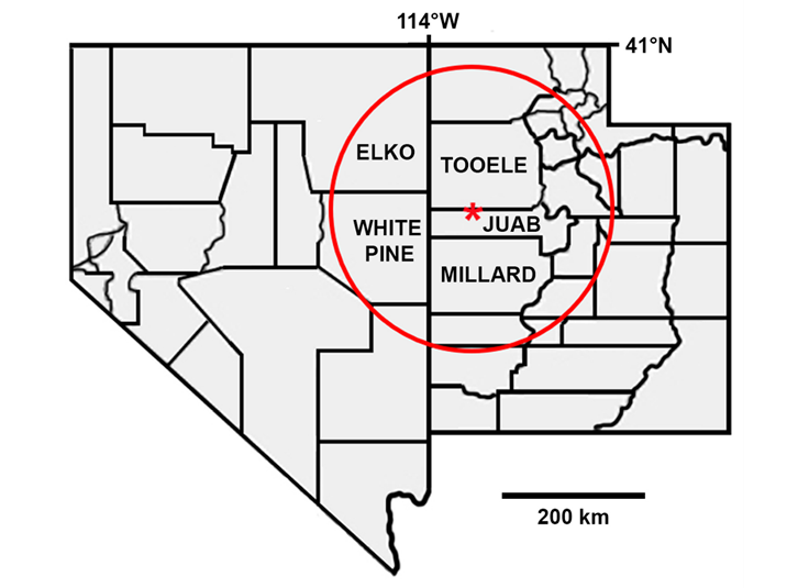
Figure 2 Map of Utah and Nevada showing location of Fish Springs (red star) in Juab County, Utah, and adjacent counties in both states. Red circle denotes the area within a 200 km radius of Fish Springs from which regional specimen records were retrieved.
We retrieved specimen records from the following institutions (with collection acronyms): Brigham Young University Life Science Museum (BYU), California State University, Long Beach (CSULB), Denver Museum of Nature and Science (DMNS), Cal Poly Humboldt Vertebrate Museum (HSUVM), Museum of Natural Science, Louisiana State University (LSUMZ), Museum of Southwestern Biology, University of New Mexico (MSB), Museum of Vertebrate Zoology, University of California, Berkeley (MVZ), Natural History Museum of Utah, University of Utah (UMNH), University of Montana Zoological Museum (UMZM), University of Nevada, Reno (UNR), Burke Museum of Natural History and Culture, University of Washington (UWBM), University of Wyoming Museum of Vertebrates (UWYMV). We verified the identification of all legacy specimens from UMNH. Duke S. Rogers verified identifications of legacy Fish Springs specimens from BYU. All specimen records are listed in Appendix 1.
Archaeological records. In 1979, test excavations were made at Barn Owl and Crab Caves located at the northern end of the Fish Springs Range within the northwestern margin of the refuge (Madsen 1982). Prehistoric faunal remains recovered by the Division of Utah State History Antiquities Division are housed in UMNH Anthropology collections. They include identified skeletal elements of 10 mammal species (Canis latrans, Antilocapra americana, Odocoileus hemionus, Ovis canadensis, Lepus californicus, Sylvilagus audubonii, Thomomys bottae, Neotoma sp. Microtus sp., and Ondatra zibethicus) dated between ca. 4000 and 1800 BP (Madsen 1982).
Species Accounts
Eulipotyphla
Soricidae (5 species, 2 of which are documented from the refuge)
Notiosorex crawfordi (Baird, 1877)
Crawford’s Gray Shrew
Fish Springs records. None.
Regional records. 4: Utah, Tooele County, Dugway Proving Grounds, site 18 C (BYU), Granite Mountain, Site 15 A (BYU), Wig Mountain (BYU), Sapphire Mountain (BYU). This species occurs in arid and semiarid habitats, including desert shrub, grassland, alkaline marsh and mud flats (Carraway and Timm 2000) all of which are extensive on the refuge and similar to habitat at the nearby regional localities in Tooele County. Its occurrence at Fish Springs is very likely.
Sorex merriami Dobson, 1890
Merriam’s Shrew
Fish Springs records. None.
Regional records. 5: Utah, Juab County, 10 mi. S Eureka (MSB); Tooele County, 6 mi. S Vernon (MSB); Nevada, Elko County, Adobe Hills (UMNH). White Pine County, 2 mi. S Baker (MVZ), Strawberry Canyon (UMNH). A widespread but uncommon species, often associated with sagebrush (Artemisia; Armstrong and Jones 1972). It may occur in the Fish Springs Range along the western margin of the refuge.
Sorex preblei Jackson, 1922
Preble’s Shrew
Fish Springs records. 1: vicinity of North Spring (UMNH).
Regional records. 3: Utah, Tooele County, Horseshoe Spring (BYU); Timpie Springs (UMNH); Nevada, Elko County, Ruby Valley USFS station (UMNH). This is an uncommon species found in a wide variety of habitats, including alkaline habitat dominated by halophytic plants (Tomasi and Hoffmann 1984; Cornely et al. 1992). The single specimen from Fish Springs was trapped in salt desert shrubland habitat dominated by saltgrass (Distichlis stricta) pickle weed (Allenrolfea occidentalis), and swampfire (Salicornia utahensis). This shrew may be present throughout much of the refuge in habitat dominated by halophytic plants.
Sorex tenellus Merriam, 1895
Inyo Shrew
Fish Springs records. None.
Regional records. 4: Utah, Juab County, Granite Creek Canyon (UMNH); Nevada, Elko County, Lamoille Canyon (UMNH); White Pine County, Lehman Creek (UMNH), Bald Mountain (UMNH). This is a poorly known species, generally found in talus and other rocky habitat across a broad elevational range (Hoffmann and Owen 1980; Rickart et al. 2017). It may occur in suitable rocky habitat along the western margin of the refuge.
Sorex vagrans Baird, 1857
Vagrant Shrew
Fish Springs records. 46: (BYU and UMNH).
Regional records. 7: Utah, Juab County, 3.6 km E, 3.5 km S summit Ibapah Peak, Deep Creek Range (BYU), Granite Creek Canyon (UMNH); Tooele County, Timpie Springs (UMNH), 7 mi N Iosepa (UMNH); Nevada, Elko County, Ruby Lake (MVZ); White Pine County, Cleveland Ranch (MVZ), Snake Range, mouth of Pole Canyon (UMNH). At Fish Springs, vagrant shrews are relatively abundant, but restricted to mesic habitats (Table 2).
Table 2 Small mammal (rodent and insectivore) occurrence records across five major habitat types at Fish Springs National Wildlife Refuge, Juab County, Utah, USA. Data from surveys conducted from 2002 to 2018 (UMNH records).
| Species | Spring edge wetland | Marsh meadow | Salt desert shrubland | Sand dune | Mixed arid shrubland | Totals | No. of occupied habitats |
| Ammospermophilus leucurus | 3 | 2 | 11 | 16 | 3 | ||
| Chaetodipus formosus | 18 | 18 | 1 | ||||
| Dipodomys microps | 3 | 24 | 8 | 35 | 3 | ||
| Dipodomys ordii | 4 | 1 | 5 | 2 | |||
| Microtus montanus | 34 | 4 | 1 | 1 | 40 | 4 | |
| Mus musculus | 22 | 6 | 2 | 1 | 31 | 4 | |
| Neotoma lepida | 13 | 13 | 1 | ||||
| Onychomys leucurus | 1 | 1 | 1 | ||||
| Peromyscus crinitus | 22 | 22 | 1 | ||||
| Peromyscus maniculatus | 16 | 1 | 10 | 53 | 24 | 104 | 5 |
| Reithrodontomys megalotis | 28 | 6 | 30 | 2 | 66 | 4 | |
| Sorex preblei | 1 | 1 | 1 | ||||
| Sorex vagrans | 32 | 13 | 45 | 2 | |||
| Total | 132 | 24 | 24 | 116 | 101 | 397 |
Chiroptera
Molossidae (1 regional species not documented from the refuge)
Tadarida brasiliensis (I. Geoffroy, 1824)
Brazilian Free-tailed Bat
Fish Springs records. None. Included in the Fish Springs species list (USFWS 2004) but there are no vouchered records.
Regional records. 7: Utah, Juab County, 4 mi N Nephi (CSULB); Millard County, Holden (UMNH); Tooele County, Dugway (UMNH), 4 mi E Camelback Mountain (UMNH), Cedar Mountains (UMNH); Nevada, White Pine County, Baker (UMNH), Snake Range, Rose Guano Cave (UMNH). This species is very widespread and roosts in both caves and buildings (Wilkins 1989). Given the proximity of regional records from Tooele County, this species likely occurs on the refuge.
Vespertilionidae (13 species, 5 of which are documented from the refuge)
Antrozous pallidus (LeConte, 1856)
Pallid Bat
Fish Springs records. None. Included in the Fish Springs species list (USFWS 2004) but there are no vouchered records.
Regional records. 5: Utah, Juab County, Callao (UMNH); Millard County, Desert Experimental Range Station (UWYMV); Tooele County, Dugway (UMNH), 2 mi NE Camelback Mountain (UMNH); Nevada, White Pine County, Rose Guano Cave (UMNH). As a widespread species associated with arid habitats, rocky outcrops and water sources (Hermanson and O’Shay 1983), it likely occurs at Fish Springs.
Corynorhinus townsendii (Cooper, 1837)
Townsend’s Big-eared Bat
Fish Springs records. None. Included in the Fish Springs species list (USFWS 2004) but there are no vouchered records.
Regional records. 9: Utah, Juab County, 12 mi W Fish Springs Wildlife Refuge (UMNH), Trout Creek Canyon (UMNH); Millard County, Gandy Mountain Cave (UMNH). Tooele County, Dugway Mountains (UMNH), Little Granite Mountain (UMNH), Gold Hill (UMNH); Nevada, Elko County, 1 mi N, 2 mi E Carlin (UNR); White Pine County, Schell Creek Range (UMNH), Cleveland Ranch (MVZ). This species is common throughout the region. It roosts in caves and mines (Kunz and Martin 1982) and is likely to forage and roost on or near the refuge.
Eptesicus fuscus (Palisot de Beauvois, 1796)
Big Brown Bat
Fish Springs records. None. Included in the Fish Springs species list (USFWS 2004) but there are no vouchered records.
Regional records. 7: Utah, Juab County, Callao (UMNH), Cherry Creek (LSUMZ); Millard County, Oak City (UMNH); Tooele County, 2 mi E Ibapah (UMNH), 0.5 mi W Johnsons Pass (UMNH); Nevada, Elko County, Ruby Valley USFS Station (UMNH); White Pine County, Baker (UMNH). This species is regionally common and frequently roosts in buildings but also uses mines and caves (Kurta and Baker 1990); it likely occurs on the refuge.
Lasionycteris noctivagans (LeConte, 1831)
Silver-haired Bat
Fish Springs records. 1: (UMNH).
Regional records. 4: Utah, Juab County, 4.5 km E, 5.4 km S summit Ibapah Peak, Deep Creek Range (BYU), Callao (UMNH); Millard County, Oak Creek Reservoir (UMNH); Tooele County, 2 mi NE Camelback Mountain (UMNH). This species is regionally common, and uses a wide variety of day roosts and hibernacula (Kunz 1982).
Lasiurus cinereus (Palisot de Beauvois, 1796)
Northern Hoary Bat
Fish Springs records. No specimen records; one recent iNaturalist record (2015; https://www.inaturalist.org/observations/2385480).
Regional records. 3: Utah. Juab County, 4.5 km E, 5.4 km S summit Ibapah Peak, Deep Creek Range (BYU); Tooele County, 3 mi N Iosepa (UMNH), Dugway Proving Grounds (BYU). This species principally roosts in trees (Shump and Shump 1982), and its occurrence on the refuge may be restricted by the lack of suitable roosts.
Myotis californicus (Audubon and Bachman, 1842)
California Myotis
Fish Springs records. None. Included in the Fish Springs species list (USFWS 2004) but there are no vouchered records.
Regional records. 3: Utah, Millard County, Muddy Spring, House Range (MSB); Tooele County, 5 mi N Ibapah (UMNH); Nevada, Elko County, Spruce Mountain (HSUVM). Distribution maps exclude this species from portions of the Great Basin (Zeveloff 1988; Simpson 1993), however nearby regional records from Tooele and Millard counties suggest that it likely occurs at Fish Springs.
Myotis ciliolabrum (Merriam, 1886)
Western Small-footed Myotis
Fish Springs records. 5: (BYU and UMNH).
Regional records. 7: Utah, Millard County, 4 mi E Oak City (UMNH); Tooele County, 1 mi E Ibapah (UMNH), Parrish Ranch, 5 mi N Ibapah (UMNH), 5 mi N Camelback Mountain (UMNH), south end of Cedar Mountains (UMNH); Nevada, Elko County, Ruby Lake (MVZ); White Pine County, Mt. Moriah (MVZ). Based on the number of specimens, this is the most abundant bat at Fish Springs.
Myotis evotis (H. Allen, 1864)
Long-eared Myotis
Fish Springs records. None. Included in the Fish Springs species list (USFWS 2004) but there are no vouchered records.
Regional records. 6: Utah, Juab County, Cherry Creek (LSUMZ); Millard County, Oak Creek Canyon (UMNH); Tooele County, Harker Canyon (BYU), southwest base of Stansbury Mountains (UMNH); Nevada, Elko County, Spruce Mountain (HSUVM); White Pine County, 2 mi W Smith Creek Cave, Mt. Moriah (MVZ). A common regional species that occurs in a wide range of habitats but is most common in forest (Manning and Jones 1989). It likely occurs on the refuge.
Myotis lucifugus (LeConte, 1831)
Little Brown Myotis
Fish Springs records. 2: (UMNH).
Regional records. 5: Utah, Juab County, 4.5 km E, 5.4 km S summit Ibapah Peak, Deep Creek Range (BYU), York (UMNH); Millard County, Pavant Range, Robins Valley (UMNH); Tooele County, Skull Valley (UMNH); Nevada, Elko County, Ruby Lake (MVZ). This is a common regional species.
Myotis thysanodes Miller, 1897
Fringed Myotis
Fish Springs records. None. Included in the refuge species list (USFWS 2004) but there are no vouchered records.
Regional records. None. There are no recorded specimen records for this species from within the Great Basin. The closest vouchered records are from Garfield (MSB), Utah (BYU), Washington (UMNH) and Wayne (MSB) counties in Utah, and Clark County, Nevada (CSULB and MSB). Although this species uses a wide variety of habitats including arid shrublands (O’Farrell and Studier 1980), the absence of regional specimen records suggests that it is unlikely to occur at Fish Springs.
Myotis volans (H. Allen, 1866)
Long-legged Myotis
Fish Springs records. 1: (BYU).
Regional records. 5: Utah, Juab County, Deep Creek Mountains, Basin Creek Pass (UMNH), Cherry Creek (LSUMV); Tooele County, Cedar Mountains (UMNH), Sheeprock Mountains (BYU); Nevada, Elko County, Spruce Mountain (HSUVM); White Pine County, 7 mi SE Mt Moriah (MVZ).
Myotis yumanensis (H. Allen, 1864)
Yuma Myotis
Fish Springs records. None. Included in the refuge species list (USFWS 2004) but there are no vouchered records.
Regional records. none. There are no recorded specimen records for this species from the eastern Great Basin, where they appear to be excluded in published range maps (Zeveloff 1988; Braun et al. 2015). The closest vouchered records in Utah are from Cache (BYU), Emery (BYU), Utah (BYU), Iron (UMNH) and Washington (UMNH) counties, plus additional records from Clark County, NV (MSB) and Owyhee County, ID (MVZ). This species is unlikely to occur at Fish Spring.
Parastrellus hesperus (H. Allen, 1864)
Canyon Bat
Fish Springs records. 4: (BYU and UMNH).
Regional records. 3: Utah, Tooele County, Staley Spring, Dugway Range (UMNH), 18 mi SW Orr’s Ranch, Skull Valley (UMNH), 3 mi E Camelback Mountain (UMNH). There are relatively few regional records for this species. Fish Springs is the only vouchered locality in Juab County.
Carnivora
Felidae (2 species, 1 of which is documented from the refuge)
Lynx rufus (Schreber, 1777)
Bobcat
Fish Springs records. 8: (UMNH).
Regional records. 10: Utah, Juab County, Trout Creek (UMNH), 7 mi W Joy (UMNH); Millard County, 4 mi S Gandy (MVZ), 30 mi W Delta (BYU); Tooele County, Gold Hill (UMNH), Dugway Valley (UMNH), Simpson Mountains (UMNH); Nevada, Elko County, Spruce Mountain (MVZ); White Pine County, Snake Range (UMNH), Duck Creek (MSB). This species is likely common as a predator of small and medium-sized mammals.
Puma concolor (Linnaeus, 1771)
Mountain Lion
Fish Springs records. None.
Regional records. 7: Utah, Juab County, Deep Creek Mountains, Granite Creek Canyon (UMNH), mouth of Red Cedar Canyon (UMNH); Millard County, Eightmile Creek (UMNH); Nevada, Elko County, Cold Creek, Ruby Mountains (MVZ); White Pine County, Snake Range, Chokecherry Creek (MVZ), Great Basin National Park, near Baker Creek (UMNH), Big Wash (UMNH). Although mountain lions are regionally common, they are dependent upon presence of native ungulate prey (Currier 1983), and their occurrence at Fish Springs would likely be sporadic.
Canidae (4 species, 2 of which are documented from the refuge)
Canis latrans Say, 1823
Coyote
Fish Springs records. 2: (UMNH).
Regional records. 8: Utah, Juab County, Cane Springs (UMNH), 7 mi W Joy (UMNH), Trout Creek (UMNH); Millard County, 6 mi W Deseret (MVZ), Garrison (MVZ); Tooele County, Grassy Mountains (UMNH). Nevada, Elko County, 5 mi W Wendover (UMNH); White Pine County, Steptoe Creek (MVZ). Coyotes are commonly observed in and around the refuge (USFWS 2004). Madsen (1982) reported prehistoric skeletal remains from Barn Owl Cave.
Urocyon cinereoargenteus (Schreber, 1775)
Gray Fox
Fish Springs records. None.
Regional records. 5: Utah, Juab County, between Callao and Trout Creek (UMNH); Tooele County, 5 mi S Gold Hill (UMNH); Nevada, White Pine County, Snake Creek (MVZ), Lexington Creek (MVZ), Stella Lake (UMNH). As a widespread habitat generalist (Fritzell and Haroldson 1982) with nearby regional specimen records, this species may occur on the refuge.
Vulpes macrotis Merriam, 1888
Kit Fox
Fish Springs records. 6: (UMNH).
Regional records. 10: Utah: Juab County, Topaz Mountain (UMNH), 1 mi SW Callao (UMNH); Millard County, Swasey Reservoir (BYU), 28 mi E NV border (BYU), Desert Experimental Range Station (UMNH); Tooele County, Dugway Valley (UMNH), 5 mi NE Granite Mountain (UMNH), 2 mi S Simpson Springs (UMNH); Nevada, Elko County, 3 mi E Silverzone Pass (UMNH); White Pine County, near Ely (BYU). Kit fox are common throughout the region as a small predator of rodents (Egoscue 1962).
Vulpes vulpes (Linnaeus, 1758)
Red Fox
Fish Springs records. None. Included in the Fish Springs species list (USFWS 2004) but there are no vouchered records.
Regional records. 1: Utah, Millard County, Garrison (UMNH). The Garrison specimen is the only Arctos record for this species within the eastern Great Basin, and distribution maps exclude it from the region (Barnes 1927; Durrant 1952; Hall 1981). As such, it’s occurrence at Fish Springs seems highly unlikely.
Mustelidae (2 species documented from the refuge)
Neogale frenata (Lichtenstein, 1831)
Long-tailed Weasel
Fish Springs records. 1: (UMNH).
Regional records. 9: Utah, Juab County, 3 mi N Nephi (UMNH); Millard County Deseret (MVZ), Pavant Range, Robins Valley (UMNH); Tooele County, Little Granite Mountain (UMNH), 4 mi N Wig Mountain (UMNH), Cedar Mountains (UMNH); Nevada, Elko County, East Humboldt Range, Jerry Crab Spring (UMNH); White Pine County, Baker Creek (MVZ), Steptoe Creek (MSB). This species is common throughout the region.
Taxidea taxus (Schreber, 1777)
American Badger
Fish Springs records. 2: (UMNH).
Regional records. 10: Utah, Juab County, 2 mi W Trout Creek (UMNH); Millard County, Conger Springs (BYU), 4 mi W Deseret (MVZ); Tooele County, Ibapah (UMNH), 8 mi SW Simpson Spring (UMNH), Wig Mountain (UMNH); Nevada, Elko County, Montello (MVZ), 25 mi S Wells (UMZM); White Pine County, 7 mi W Utah State line (UMNH), Lehman Creek (MVZ). This species is common throughout the region.
Mephitidae (2 species documented from the refuge)
Mephitis mephitis (Schreber, 1776)
Striped Skunk
Fish Springs records. 4: (UMNH).
Regional records. 6: Utah, Millard County, 1 mi S Deseret (UMNH), Black Rock (UMNH); Tooele County, 0.5 mi N Granite Mountain (UMNH); 4 mi N Camelback Mountain (UMNH); Nevada, Elko County, Mary’s River, 26 mi N Deeth (MVZ); White Pine County, Home Farm, 2.4 km N, 5.2 km W Baker (UMNH). This species is common throughout the region.
Spilogale gracilis Merriam, 1890
Western Spotted Skunk
Fish Springs records. 3: (UMNH).
Regional records. 9: Utah, Juab County, Callao (BYU), Deep Creek Range, Granite Creek Canyon (UMNH), above junction of Birch and Trout creeks (UMNH); Millard County, Confusion Range (UMNH), 16 mi N Deseret (MVZ); Tooele County, Granite Peak (BYU), Dugway Valley (UMNH); Nevada, Elko County, Ruby Mountains, vicinity of Flyn Spring (UMNH); White Pine County, McGill (UMZM). This species is common throughout the region.
Procyonidae (2 species, 1 of which is documented from the refuge)
Bassariscus astutus (Lichtenstein, 1830)
Ringtail
Fish Springs. 1: (UMNH).
Regional records. 4: Utah, Juab County, Deep Creek Mountains, Birch Creek Canyon (UMNH), mouth of Granite Creek Canyon (UMNH), mouth of Red Cedar Canyon (UMNH), Tooele County, South Willow Canyon (BYU); Nevada, White Pine County, Baker (UMNH). This species is likely common in rock outcrops along the eastern margin of Fish Springs Range adjacent to the refuge.
Procyon lotor (Linnaeus, 1758)
Raccoon
Fish Springs. No specimen records; one recent iNaturalist record (2019; https://www.inaturalist.org/observations/27973320).
Regional record. 1: Utah, Tooele County, Oquirrh Mountains, Middle Canyon (UMNH). Historically, the raccoon was considered rare in Utah (Durrant 1952), and distribution maps have excluded it from the region (Barnes 1927; Hall 1946, 1981; Zeveloff 1988). The specimen from Tooele County, collected in 1989, is the only Arctos record from the eastern Great Basin. In recent decades raccoons have expanded into western Utah as documented from state trapping records (Kamler et al. 2003). The 2019 iNaturalist record strongly suggests that this species either has or may become established at Fish Springs.
Perissodactyla
Equidae (1 regional species not documented from the refuge)
Equus caballus Linnaeus, 1758
Horse (feral)
Fish Springs records. None.
Regional records. none. Although there are no regional specimen records, feral horses are common in the region, with nearby herds that are managed by the US Bureau of Land Management (https://www.blm.gov/programs/wild-horse-and-burro/herd-management/herd-management-areas/utah). At least occasionally, feral horses likely occur at Fish Springs.
Artiodactyla
Antilocapridae (1 species documented from the refuge)
Antilocapra americana (Ord, 1815)
Pronghorn
Fish Springs records. No recent specimen records.
Regional records. 4: Utah, Millard County, Desert Experimental Range Station (UMNH); Tooele County, 8 mi SW Simpson Spring (UMNH), 5 mi N Camelback Mountain (UMNH), Dugway Valley (UMNH). Pronghorn are frequently observed along the western margin of the refuge (USFWS 2004). Prehistoric skeletal remains were reported from Barn Owl Cave (Madsen 1982).
Cervidae (1 species documented from the refuge)
Odocoileus hemionus (Rafinesque, 1817)
Mule Deer
Fish Springs records. No recent specimen records.
Regional records. 8: Utah, Juab County, 5 mi S Nephi (BYU); Millard County, 2 mi N Oak City (BYU); Tooele County, Candy Creek, Cedar Mountains (UMNH), Benmore Guard Station (UMNH); Nevada, Elko County, Ruby Mountains, Lamoille Canyon (UMNH); White Pine County, Lehman Creek (MVZ), Baker Creek (MVZ), Duck Creek Valley (MSB). Deer reportedly occur on or near the refuge during summer and autumn (USFWS 2004). Prehistoric skeletal remains were reported from Barn Owl and Crab Caves (Madsen 1982).
Bovidae (1 species documented from the refuge)
Ovis canadensis Shaw, 1804
Bighorn Sheep
Fish Springs records. No recent specimen records.
Regional records. 5: Utah, Tooele County, Granite Mountain (UMNH), Lakeside Mountains (UMNH); Nevada, White Pine County, Hendry Creek (MVZ), Baker Creek (MVZ), Stella Lake (MVZ). All regional records are based on salvaged specimens (heavily weathered partial skulls). Prehistoric skeletal remains were reported from Barn Owl Cave (Madsen 1982). Overhunting and/or disease transmission from domestic sheep probably eradicated bighorn sheep locally by the early 20th century (Besser et al. 2012; Cassirer et al. 2017) however regional reintroduction efforts (Utah Division of Wildlife Resources 2018) may eventually lead to their reestablishment in the Fish Springs Range.
Rodentia
Sciuridae (6 species, 1 of which is documented from the refuge)
Ammospermophilus leucurus (Merriam, 1889)
White-tailed Antelope Squirrel
Fish Springs records. 28: (BYU and UMNH).
Regional records. 12: Juab County, Fish Springs Range (UMNH), junction Snake Valley and Granite Creek roads (UMNH), 5.5 mi S, 7.8 mi E Callao (MVZ), 6.7 mi S, 5.3 mi E Callao (MSB), 1.5 mi N Topaz Mountain (UMNH); Millard County, Tule Valley (UWYMV), Marjum Pass (UMNH), Gandy Salt Marsh (BYU); Tooele County, Gold Hill (BYU), Granite Mountain (UMNH), Camelback Mountain (UMNH); Nevada, White Pine County, Baker (UMNH). This species is common and widespread on the refuge, particularly in mixed shrublands (Table 2).
Marmota flaviventris (Audubon and Bachman, 1841). Yellow-bellied Marmot
Fish Springs records. None.
Regional records. 5: Utah, Juab County, 4 mi W Eureka (UMNH); Tooele County, 9 mi S Vernon (BYU), Stansbury Mountains (UMNH); Nevada, Elko County, Lamoille Creek (MVZ) White Pine County, Baker Creek Canyon (UMNH). Reported (sighting) from Granite Creek Canyon, Deep Creek Range 35 km west of Fish Springs (Shippee and Egoscue 1958). Marmots may be present in the Fish Springs Range west of the refuge.
Neotamias dorsalis (Baird, 1855)
Cliff Chipmunk
Fish Springs records. None.
Regional records. 9: Utah, Juab County, Deep Creek Mountains, 4.0 km E, 4.4 km S Ibapah Peak (BYU), mouth of Indian Farm Canyon (UMNH), Cherry Creek (UMNH); Millard County, 1 mi N Sinbad Spring (UMNH); Tooele County, 1 mi N Gold Hill (UMNH), Granite Peak (UMNH), Indian Springs (UMNH); Nevada, Elko County, Ferguson Hills (UMNH); White Pine County, Mt. Moriah (MVZ). This species generally occurs in rocky areas in shrubland or woodland habitats (Hart 1992); it may occur in the western-most portions of the refuge.
Neotamias minimus (Bachman, 1839).
Least Chipmunk
Fish Springs records. None. Included in the Fish Springs species list (USFWS 2004) but there are no vouchered records.
Regional records. 14: Utah, Juab County, Deep Creek Mountains, Granite Creek Canyon (UMNH), mouth of Indian Farm Canyon (UMNH); Millard County, Gandy (MVZ). Pavant Range (UMNH); Tooele County, Clifton Flat (UMNH), NW of Granite Peak (UMNH), 8 mi SW Wig Mountain (UMNH), 3 mi W Camelback Mountain (UMNH); Nevada, Elko County, Dolly Varden Mountains (UMNH), Cherry Creek Mountains (DMNS), Spruce Mountain (HSUVM); White Pine County, Shellbourne Pass (MVZ), Steptoe Valley (MVZ), Strawberry Creek Canyon, Snake Range (UMNH). This species occurs in shrubland, generally in areas dominated by sagebrush (Verts and Carraway 2001). It may occur in mixed shrub habitat on the western portion of the refuge.
Urocitellus mollis (Kennicott, 1863)
Piute Ground Squirrel
Fish Springs records. None.
Regional records. 12: Utah, Juab County, 5 mi SE Fish Springs (UMNH), 0.7 mi N Black Rock Hills (UMNH), Thomas Range (UMNH), 2.5 mi E Topaz Mountain (UMNH); Millard County, Deseret (MVZ), 15 mi S, 6 mi E Garrison (UMNH); Tooele County, 2 mi S Ibapah (UMNH), 5.7 mi W Simpson Springs (UMNH); Nevada, Elko County, Currie (UWBM), Montello (MSB); White Pine County, Steptoe Valley (MVZ), Spring Valley (MVZ). This species may be present throughout much of Fish Springs Flat in the eastern portion of the refuge. It is dormant during most of the year, but active during the day above ground from late winter to late spring (Rickart 1987).
Otospermophilus variegatus (Erxleben, 1777)
Rock Squirrel
Fish Springs records. None.
Regional records. 10: Utah, Juab County, 7 mi S Callao (UWBM), Granite Creek Canyon, Deep Creek Mountains (UMNH), Ferner Valley (MSB); Millard County, Oak Creek Canyon (UMNH), Meadow (UMNH); Tooele County, Death Canyon, Simpson Mountains (UMNH), Little Valley Ranger Station, Sheeprock Mountains (UMNH); Nevada, White Pine County, Cherry Creek (MVZ), Cleve Creek, Schell Creek Range (MVZ). Snake Creek, Snake Range (UNR). This is a common regional species that may occur in the Fish Springs Range west of the refuge.
Heteromyidae (6 species, 3 of which are documented from the refuge)
Dipodomys microps (Merriam, 1904)
Chisel-toothed Kangaroo Rat
Fish Springs records. 55: (BYU and UMNH).
Regional records. 12: Utah, Juab County, south side Topaz Mountain (CSULB), junction Granite Creek Road and Snake Valley Road (BYU), Joy (BYU); Millard County, Tule Valley (UWYMV), 1 mi SE Gandy (MVZ); Tooele County, Dugway Proving Ground (MSB), Dugway Valley (UWBM), 3 mi SW Gold Hill (UMNH); Nevada, Elko County, Leppy Peak (UMNH); White Pine County, Steptoe Valley (MVZ), Spring Valley (MSB), Baker (UMNH). This widespread species is and abundant on the refuge, particularly in areas with Atriplex spp. (Table 2).
Dipodomys ordii Woodhouse, 1853
Ord’s Kangaroo Rat
Fish Springs records. 13: (BYU and UMNH).
Regional records. 14: Utah, Juab County, Sand Pass (UMNH), Callao (BYU), Topaz Mountain (CSULB), Joy (BYU), Trout Creek (MVZ); Millard County, Tule Valley (UWYMV), Gandy Salt Marsh (BYU); Tooele County, Dugway Proving Ground (MSB), 1 mi W Five Mile Hill (UMNH); Nevada, Elko County, Salt Spring (MVZ), Shanty Town (UMNH); White Pine County, Mt. Moriah (MVZ), Spring Valley (MSB), Baker (UMNH). Although regionally widespread, this species is much less abundant on the refuge than D. microps (Table 3).
Table 3 Number of small mammal (rodent and shrew) occurrence records and percent relative abundance of species from trapping surveys at Fish Springs National Wildlife Refuge, Juab County, Utah, USA. Records from BYU (1992) and UMNH (1940, 2002-2018).
| 1940 | 1992 | 2002-2003 | 2012 | 2015-2018 | |||||
|---|---|---|---|---|---|---|---|---|---|
| Species | n (% total) | n (% total) | n (% total) | n (% total) | n (% total) | ||||
| Ammospermophilus leucurus | 1 (2.7) | 6 (5.1) | 7 (3.8) | 9 (6.1) | 2 (2.0) | ||||
| Chaetodipus formosus | 0 | 0 | 16 (8.7) | 2 (1.3) | 3 (3.1) | ||||
| Dipodomys microps | 4 (10.8) | 18 (11.4) | 21 (11.4) | 10 (6.8) | 6 (6.1) | ||||
| Dipodomys ordii | 5 (13.5) | 4 (3.4) | 3 (1.6) | 1 (0.7) | 1 (1.0) | ||||
| Microtus montanus | 4 (10.8) | 2 (1.7) | 11 (6.0) | 8 (5.4) | 20 (20.4) | ||||
| Mus musculus | 0 | 8 (6.8) | 18 (9.8) | 13 (8.9) | 0 | ||||
| Neotoma lepida | 2 (5.4) | 0 | 4 (2.2) | 9 (6.1) | 3 (3.1) | ||||
| Onychomys leucurus | 0 | 1 (0.9) | 1 (0.5) | 0 | 0 | ||||
| Peromyscus crinitus | 0 | 0 | 7 (3.8) | 15 (10.1) | 0 | ||||
| Peromyscus maniculatus | 20 (54.1) | 45 (38.5) | 49 (26.6) | 37 (25.0) | 32 (32.7) | ||||
| Reithrodontomys megalotis | 1 (2.7) | 32 (27.4) | 26 (14.1) | 32 (21.6) | 18 (18.4) | ||||
| Sorex preblei | 0 | 0 | 0 | 0 | 1 (1.0) | ||||
| Sorex vagrans | 0 | 1 (0.9) | 21 (11.4) | 12 (8.1) | 12 (12.2) | ||||
| Total | 37 | 117 | 184 | 148 | 98 |
Microdipodops megacephalus Merriam, 1891
Dark Kangaroo Mouse
Fish Springs records. None.
Regional records. 15: Utah, Juab County, 3 mi SSW Fish Springs (UMNH), 5.5 mi S, 7.8 mi E Callao (MSB), 6.7 mi S, 5.3 mi E Callao (MSB), 7.7 mi N, 2.7 mi E Callao (MVZ), 4.5 mi NE Trout Creek (UMNH), 4 mi SW Trout Creek (UMNH); Millard County, Tule Valley (UWYMV), 5 mi S Gandy (MVZ); Tooele County, 8 mi E Granite Mountain (UMNH), 3 mi N Granite Mountain (UMNH), 2 mi NE Camelback Mountain (UMNH); Nevada, Elko County, Cobre (MVZ), Ruby Lake National Wildlife Refuge (UMNH); White Pine County, 7 mi SW Osceola (MVZ), 4 mi S Shoshone (MVZ). This is a Great Basin endemic species of conservation concern. Populations have been declining, and Fish Springs is near the eastern limit of the geographic range (Anderson et al. 2013; Light et al. 2013). Kangaroo mice may occur on the refuge in areas with suitable soil and plant cover.
Chaetodipus formosus (Merriam, 1899)
Long-tailed Pocket Mouse
Fish Springs records. 26: (BYU and UMNH).
Regional records 12: Utah, Juab County, 3 mi W Callao (UMNH), junction Granite Creek and Snake Valley roads (UMNH), Sand Pass (UMNH), Topaz Mountain (CSULB); Millard County, Swasey Springs (UMNH), Gandy Salt Marsh (BYU), Black Rock (UMNH); Tooele County, 3.0 km E, 0.4 km S Young Peak, Deep Creek Range (BYU), Dugway Mountains (UMNH); Nevada, Elko County, Goshute Mountains (MVZ), Leppy Peak (UMNH); White Pine County, Mt. Moriah (MVZ). This species is regionally abundant, and common in mixed arid shrubland along the western margin of the refuge (Table 2).
Perognathus longimembris (Coues, 1875)
Little Pocket Mouse
Fish Springs records. None.
Regional records. 15: Utah, Juab County, 1 mi S Callao (UMNH), 0.25 km E, 0.20 km S junction Granite Creek Road and Snake Valley Road (BYU), Trout Creek (UMNH), Leland Harris Spring (BYU), Sand Pass (UMNH), Joy (BYU); Millard County, Tule Valley (UWYMV), Desert Experimental Range (MSB); Tooele County, Table Mountain (UMNH), 4 mi NW Camelback Mountain (UMNH), 6 mi NE Granite Mountain (UMNH); Nevada, Elko County, 16 mi S Montello (UMNH), Ruby Lake National Wildlife Refuge (UMNH); White Pine County, Mt. Moriah (MVZ), 1.6 mi N Baker (MVZ). Regionally common, this species may occur in areas on the refuge with suitable soil and plant cover.
Perognathus mollipilosus (Coues, 1875)
Great Basin Pocket Mouse
Fish Springs records. None.
Regional records. 15: Utah, Juab County, Callao (BYU), Deep Creek Mountains, Granite Creek Canyon (UMNH), Joy (BYU); Millard County, House Range (UMNH), Marjum Pass, House Range (BYU), 7 mi SW Skull Rock Pass (MVZ); Tooele County, Dugway Mountains (UMNH), Simpson Mountains (UMNH), Clifton Flat (UMNH); Nevada, Elko County, Dolly Varden Mountains (UMNH), Spruce Mountain (MVZ), East Humboldt Range (UMNH); White Pine County, Mt. Moriah (MVZ), Schellbourne Pass (MVZ), Spring Valley (UMNH). This species occurs throughout the Great Basin and is common in arid habitat with sandy soil where sagebrush (Artemisia spp) is dominant (Verts and Kirkland 1988); it may occur in the northwestern portion of the refuge.
Geomyidae (1 species documented from the refuge)
Thomomys bottae (Eydoux and Gervais, 1836)
Botta’s Pocket Gopher
Fish Springs records. 30: (BYU and UMNH).
Regional records. 13: Utah, Juab County, Sand Pass (UMNH), Callao (UMNH), Trout Creek (UMNH); Millard County, Tule Valley (UWYMV), Swasey Spring (UMNH), Marjum Pass (UMNH); Tooele County, Dugway Range (UMNH), Five Mile Hill (UMNH), Granite Mountain (UMNH); Nevada, Elko County, Pilot Creek (UMNH); White Pine County, Mt. Moriah (MVZ), 2.5 mi E Baker (MVZ), Snake Creek Canyon (UMNH). Fish Springs is the type locality for the subspecies T. bottae bonnevillei Durrant,1946. This species is common throughout the region within which there are several recognized local subspecies (Patton 2005).
Cricetidae (10 species, 6 of which are documented from the refuge).
Lemmiscus curtatus (Cope, 1868)
Sagebrush Vole
Fish Springs records. None.
Regional records. 12: Utah, Juab County, Deep Creek Mountains, mouth of Indian Farm Canyon (UMNH), Queen of Sheba Canyon (UMNH), 2.7 km N, 1.3 km E Indian Springs (UMNH); Millard County, Marjum Pass, House Range (BYU); Tooele County, 7 mi SW Gold Hill (UMNH), Simpson Springs (UMNH); Nevada, Elko County, Dolly Varden Mountains (UMNH), Cobre (MVZ), 20 mi N Wells (UMNH); White Pine County, Mt. Moriah (MVZ), Schell Creek Range MVZ), 2 mi NW Sacramento Pass (UMNH). This species is usually found in association with sagebrush (Artemisia spp) in areas with well-drained soils (Carroll and Genoways 1980). It may occur in mixed shrubland in the northwestern part of the refuge that includes a portion of the Fish Springs Range.
Microtus longicaudus (Merriam, 1888)
Long-tailed Vole
Fish Springs records. None.
Regional records. 15: Utah, Juab County, Deep Creek Mountains, Indian Farm Canyon (UMNH), Tom’s Creek (HSUVM), Granite Creek Canyon (UMNH); Millard County, Sinbad Spring (UMNH), 4 mi E Oak City (UMNH), Fillmore (BYU); Tooele County, Simpson Springs (UMNH), Indian Springs (UMNH), Hard to Beat Canyon (BYU); Nevada, Elko County, 12.5 mi SW Wendover (UMNH), Debbs Creek, Pilot Range (BYU), Spruce Mountain (MVZ); White Pine County, Mt. Moriah (MVZ), Snake Range, mouth of Pole Canyon (UMNH), south fork Big Wash (UMNH). This species may occur in mesic habitat or arid grassland on the refuge.
Microtus montanus (Peale, 1848)
Montane Vole
Fish Springs records. 55: (BYU and UMNH).
Regional records. 10: Utah, Juab County, Callao (UMNH); Millard County, 5 mi S Garrison (MVZ); Tooele County, 1 mi E Ibapah (UMNH), 7.5 mi E Granite Mountain (UMNH); Nevada, Elko County, Ferguson Springs (UMNH), Salt Spring (MVZ), Currie (UWBM); White Pine County, Baker (UMNH), Cleveland Ranch (MVZ), 7 mi SW Osceola (MVZ). Montane voles are abundant on the refuge, but largely restricted to mesic habitat (Table 2).
Ondatra zibethicus (Linnaeus, 1766)
Muskrat
Fish Springs records. 88: (BYU and UMNH).
Regional records. 7: Utah, Juab County, Mills (UMNH); Millard County, 10 mi N Deseret (MVZ), 5 mi S Garrison (MVZ); Tooele County, Ibapah (UMNH), Horseshoe Springs (BYU); Nevada, Elko County, Ruby Lake (MVZ); White Pine County, Lehman Creek (UMNH). As a commercially valuable furbearer, this species has been introduced to many areas where it was not present historically (Hall 1946, 1981; Durrant 1952). The occurrence of muskrats at Fish Springs was first noted by Barnes (1927) where they were reported to have been introduced in 1925 (McCabe 1982; also see Bolen 1964), and therefore considered to be non-native (USFWS 2004). Introduced animals may have been sourced from the Bear River Migratory Bird Refuge where non-native muskrats from the eastern US were introduced to improve the size and quality of the pelts (Durrant 1952). Despite the probable introduction of non-native muskrats to Fish Springs, skeletal material from Barn Owl Cave documents prehistoric occurrence of native muskrats (Figure 3; Madsen 1982). Muskrats are abundant on the refuge and are considered beneficial in maintaining suitable habitat for waterfowl (USFWS 2004).
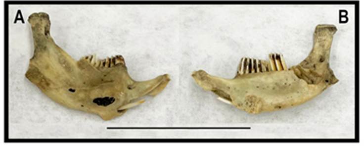
Figure 3 A) Labial and B) lingual views of a partial muskrat right hemimandible from Barn Owl Cave, Fish Springs National Monument dated between ca. 4000 and 1800 BP. UMNH archaeological collection (42Jb25 AS.78.28.5.11). Scale bar = 3 cm.
Neotoma lepida (Thomas, 1893)
Desert Woodrat
Fish Springs records. 27: (BYU and UMNH).
Regional records. 15: Utah, Juab County, Deep Creek Range, Granite Creek Canyon (UMNH), Trout Creek (BYU), south side Topaz Mountain (CSULB); Millard County, Tule Valley (UWYMV), Swasey Spring (UMNH), Gandy Salt Marsh (BYU); Tooele County, Cane Spring (MSB), Granite Peak (UMNH), Dugway Valley (UWBM); Nevada, Elko County, Ferguson Hills (UMNH). 9.8 km S, 4.4 km W West Wendover (UMNH), 1.5 mi SW Currie (MVZ); White Pine County, Mt. Moriah (MVZ), South Snake Ridge (UNR), Baker (MVZ). This species is common throughout the region, but most often found in rocky habitat. Most specimens from the refuge were trapped in arid shrubland along the base of the Fish Springs Range (Table 2).
Onychomys leucogaster (Wied-Neuwied, 1841)
Northern Grasshopper Mouse
Fish Springs records. 2: (BYU and UMNH).
Regional records. 15: Utah, Juab County, 7 mi S Fish Springs (UMNH), Trout Creek (UMNH), Little Sahara near Cherry Creek Wash (BYU); Millard County, Tule Valley (UWYMV), 4 mi S Gandy (MVZ), 7 km S Oak City (MSB); Tooele County, 2 mi N Fish Springs Mountains (UMNH), Dugway Valley (UWBM), 3 mi SW Gold Hill (UMNH); Nevada, Elko County, Tecoma (MVZ), Cobre (MVZ), Davis Spring (UMNH); White Pine County, Baker (UMNH), Spring Valley (MSB), Steptoe Creek (MVZ). The species occurs throughout the region, but is much less common locally than most other rodent species (Table 3).
Peromyscus crinitus (Merriam, 1891)
Canyon Mouse
Fish Springs records. 32: (BYU and UMNH).
Regional records. 14: Utah, Juab County, 7 mi S Fish Springs (UMNH). Granite Creek Canyon, Deep Creek Mountains (UMNH), confluence of Birch and Trout creeks (UMNH); Millard County, Gandy Salt Marsh (BYU), Marjum Pass (UMNH), west of Meadow (UMNH); Tooele County, Dugway Mountains (UMNH), Granite Peak Range (UMNH), 1 mi SW Gold Hill (UMNH); Nevada, Elko County, Leppy Peak (UMNH), 9.8 km S, 4.4 km W West Wendover (UMNH); White Pine County, Mt. Moriah (MVZ), Schell Creek Range (MVZ), Cherry Creek (MVZ). This species is a habitat specialist that occurs on rocky slopes. The species is restricted to the mixed arid shrubland along the western margin of the refuge where it is common (Table 2).
Peromyscus maniculatus (Wagner, 1845)
Deer Mouse
Fish Springs records. 117 (BYU and UMNH).
Regional records. 15: Utah, Juab County, Fish Springs Range (UMNH), Sand Pass (UMNH), Trout Creek (BYU); Millard County, 4 mi S Gandy (MVZ), Swasey Spring (UMNH), 7 mi SW Skull Rock Pass (MVZ); Tooele County, Clifton Flat (UMNH), 18 mi SW Orr’s Ranch (UMNH), Simpson Springs (MSB); Nevada, Elko County, Leppy Peak (UMNH), Dolly Varden Mountains (UMNH), Spruce Mountain (MVZ); White Pine County, Mt. Moriah (MVZ), Baker (UMNH), Pyramid Peak (UMNH). As an abundant ecological generalist, this is the only species that occurs in all habitats on the refuge and is the most abundant small mammal across all sampling periods (Tables 2 and 3).
Peromyscus truei (Shufeldt, 1885)
Pinyon Mouse
Fish Springs records. None. Included in the refuge species list (USFWS 2004) based on one record (below) from the adjacent Fish Springs Range.
Regional records 15: Utah, Juab County, Fish Springs Range (BYU), Indian Farm Canyon (BYU), confluence Birch and Trout creeks (UMNH); Millard County, Marjum Pass (BYU), 4 mi S Oak City (BYU), Desert Experimental Range Station (UMNH); Tooele County, 7 mi NE Granite Peak Range (UMNH), Dugway Proving Ground, Cane Spring (MSB), Simpson Springs (UMNH); Nevada, Elko County, Ferguson Hills (UMNH), Toano Peak (BYU), Debbs Creek, Pilot Peak (MVZ); White Pine County, Snake Creek Canyon (UNR), Schell Creek Range (MVZ), Cherry Creek (MVZ). The geographic range of pinyon mice is expanding in much of the intermountain west with the spread of pinyon-juniper woodland (Massey et al. 2017). The species is known from a nearby locality in the Fish Springs Range, and likely occurs on the northwestern margin of the refuge.
Reithrodontomys megalotis (Baird, 1857)
Western Harvest Mouse
Fish Springs records. 76: (BYU and UMNH).
Regional records 15: Utah, Juab County, Sand Pass (UMNH), 0.5 mi S Callao (UMNH), Granite Creek Canyon (UMNH); Millard County, Tule Valley (UWYMV), 1 mi SE Gandy (MVZ), Robinson Ranch (MVZ); Tooele County, Clifton Flat (UMNH), 7 mi NE Granite Peak Range (UMNH), Indian Springs (UMNH); Nevada, Elko County, Salt Springs (MVZ), Debbs Creek (BYU), Toano Peak (BYU); White Pine County, Mt. Moriah (MVZ), Baker (UMNH), Sacramento Pass (UMNH). Harvest mice are common throughout the region and occur in most habitats on the refuge (Table 2).
Muridae (1 species documented from the refuge)
Mus musculus Linnaeus, 1758
House Mouse
Fish Springs records. 36: (BYU and UMNH).
Regional records 7: Utah, Juab County, Eureka (BYU), 4 mi W Mona (UMNH); Tooele County, Dugway Proving Ground (UMNH), Parish Ranch (UMNH); Nevada, Elko County, 3 mi N Jarbidge (UNR); White Pine County, Baker (UMNH), 5.5 mi SE Ely (MVZ). The earliest specimen records for house mice at Fish Springs are from 1992 (Table 3), but they may have been present much earlier, perhaps dating from increased human traffic in the early 20th century. The earliest regional specimens are from Baker [1929] and Ely (1930) in Nevada, and from Ibapah [1942] and Mona [1951] in Utah (listed above). Although regional records are sparse, house mice have been relatively abundant at Fish Springs, occurring in disturbed and heavily managed habitat, as well as in areas dominated by native vegetation (Table 2). However, there appears to have been a population crash prior to the most recent survey period when none were recorded (Table 3).
Lagomorpha
Leporidae (3 species, 2 of which are documented from the refuge)
Brachylagus idahoensis (Merriam, 1891)
Pygmy rabbit
Fish Springs records. None. Included in the Fish Springs species list (USFWS 2004) but there are no vouchered records.
Regional records. 4: Utah, Tooele County, Ibapah (UMNH), 3 mi. SE Ibapah (UMNH); Nevada, Elko County, 10 mi N Wells (UMNH); White Pine County, Spring Valley (UMNH). This species is closely associated with dense shrub cover dominated by big sagebrush (Artemisia tridentata) in areas with sandy soil (Green and Flinders 1980; Gabler et al. 2001). Although present in the region, its occurrence in or near the refuge is highly unlikely given the lack of preferred sagebrush habitat.
Sylvilagus audubonii (Baird, 1858)
Desert Cottontail
Fish Springs records. 2: (BYU).
Regional records. 11: Utah, Juab County, Callao (UMNH), Mayfield Ranch (UMNH), Snake Valley (UMNH); Millard County, Gandy Salt Marsh (BYU), 6 mi N Delta (UMNH), Desert Experimental Range Station (UMNH); Tooele County, 2 mi W Willow Spring (UMNH), Clifton Flat (UMNH), 6 mi S Ibapah (UMNH); Nevada, White Pine County, SW of Baker (BYU), Snake Creek (UNR). This species is likely very common in desert shrubland habitat on the refuge. Prehistoric skeletal remains were reported from Barn Owl Cave (Madsen 1982).
Lepus californicus Gray, 1837
Black-tailed Jackrabbit
Fish Springs records. 1: (BYU).
Regional records. 8: Utah, Juab County, Boyd’s Ranch (UMNH). 6 mi SW Eureka (MSB); Millard County, E of House Range (UMNH); Tooele County, 4 mi NW Ibapah (BYU), 4 mi E Camelback Mountain (BYU); Nevada, White Pine County, 7.3 km W Baker (BYU), Willard Creek (UMNH), Duck Creek Valley (MSB). Madsen (1982) reported prehistoric skeletal remains from Barn Owl Cave and Crab Cave (Madsen 1982). This species is commonly observed on the refuge.
Results and Discussion
Legacy specimen records together with specimens from recent survey work document a total of 33 mammal species from Fish Springs. An additional 27 species were documented from regional specimen records within the eastern Great Basin region (Figure 4). This second group includes species with variable likelihood of occurrence on the refuge as addressed in the species accounts above and discussed below. Additional species include two bats (Myotis thysanodes and M. yumanensis) that are on the refuge mammal species list (USFWS 2004) but have no specimen records from within the eastern Great Basin, and one species (feral Equus caballus) that lacks regional specimen records but has been documented on or near the refuge.
Data quality and survey thoroughness. Our study is based almost entirely on records of occurrence from museum specimens. In analyses of relative abundance of rodents and shrews across habitat type and years (Tables 1 to 3), we included some individuals that were trapped and released after identification, but distribution records for all species are based on voucher specimens.
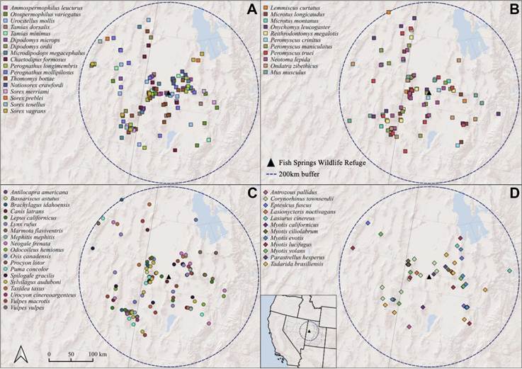
Figure 4 Maps of regional mammal specimen records from within 200 km of Fish Springs National Wildlife Refuge in western Utah (inset). A) small nonvolant species (shrews, small sciurid, heteromyid and geomyid rodents), B) small cricetid rodents, C) medium and large species (rodents, lagomorphs, ungulates and carnivorans), and D) bats.
Over the course of 85 years (1934 to 2018), specimen records have documented 33 mammal species on the Fish Springs Refuge, including some that were present in the past but may not occur there now (e. g., Ovis canadensis). A species accumulation curve across years (Figure 5) shows a stepwise increase due to the addition of multiple species during separate surveys, but it does not exhibit an extended asymptote indicating that future surveys would very likely document additional species.
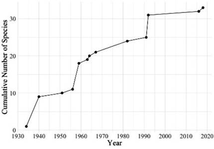
Figure 5 Cumulative number of mammal species documented over time at Fish Springs National Wildlife Refuge based on museum specimen records.
There are 27 species that either belong to the regional fauna or have been reported as occurring on the refuge but are not represented by vouchers (Table 4). More than half (15) appear in a list of mammals for the refuge in the Comprehensive Conservation Plan (USFWS 2004). Although there is no reference to the criteria for placement on the list, they presumably included sightings of diurnal species, presence of sign (tracks or scat), use of bat detectors, capture and release after field identification, and specimen records from near the refuge. The nearest vouchered regional records for these species, along with our assessment of habitat suitability on the refuge (as summarized in species accounts) provide the basis for evaluating the likelihood of occurrence at Fish Springs (Table 4).
Table 4 Mammal species without vouchered records from Fish Springs NWR, but either reported to occur there or having some likelihood of occurrence based on vouchered records elsewhere and presence of suitable habitat.
| Species | Included in FSNWR species list | Nearest voucher | Voucher distance (km) | Habitat suitability | Likelihood of occurrence |
|---|---|---|---|---|---|
| Notiosorex crawfordi | no | BYU:Mamm:33208 | 18 | high | high |
| Sorex merriami | no | MSB:Mamm:102731 | 75 | moderate | moderate |
| Sorex tenellus | no | UMNH:Mamm:37371 | 40 | moderate | moderate |
| Tadarida brasiliensis | yes | UMNH:Mamm:27275 | 50 | high | high |
| Antrozous pallidus | yes | UMNH:Mamm:27248 | 25 | high | high |
| Corynorhinus townsendii | yes | UMNH:Mamm:23958 | 20 | high | high |
| Eptesicus fuscus | no | UMNH:Mamm:27232 | 25 | high | high |
| Lasiurus cinereus | no | BYU:Mamm:36740 | 35 | moderate | moderate |
| Myotis californicus | yes | UMNH:Mamm:4424 | 55 | high | high |
| Myotis evotis | yes | BYU:Mamm:18086 | 75 | moderate | moderate |
| Myotis thysanodes | yes | BYU:Mamm:10439 | 180 | moderate | low |
| Myotis yumanensis | yes | BYU:Mamm:41155 | 140 | moderate | low |
| Puma concolor | no | UMNH:Mamm:5466 | 40 | moderate | moderate |
| Urocyon cinereoargenteus | no | UMNH:Mamm:25326 | 35 | moderate | moderate |
| Vulpes vulpes | yes | UMNH:Mamm:42254 | 110 | low | low |
| Procyon lotor | no | UMNH:Mamm:28778 | 120 | moderate | high |
| Marmota flaviventris | no | BYU:Mamm:5379 | 80 | low | low |
| Tamias dorsalis | no | UMNH:Mamm:26431 | 25 | high | high |
| Tamias minimus | yes | UMNH:Mamm:26423 | 30 | moderate | moderate |
| Urocitellus mollis | yes | UMNH:Mamm:24851 | 8 | high | high |
| Otospermophilus variegatus | no | UWBM:Mamm:42860 | 35 | moderate | moderate |
| Microdipodops megacephalus | yes | UMNH:Mamm:24772 | 5 | high | high |
| Perognathus longimembris | yes | UMNH:Mamm:25779 | 25 | high | high |
| Perognathus mollipilosus | yes | BYU:Mamm:3099 | 25 | high | high |
| Lemmiscus curtatus | no | UMNH:Mamm:25564 | 40 | moderate | moderate |
| Microtus longicaudus | no | UMNH:Mamm:26856 | 40 | moderate | moderate |
| Peromyscus truei | yes | BYU:Mamm:14698 | 4 | moderate | high |
| Brachylagus idahoensis | yes | UMNH:Mamm:7862 | 50 | low | low |
Recent survey efforts have utilized standard small mammal traps that are most effective in targeting rodents and the most common shrew species. In the future, a wider range of survey techniques would be most productive, including pitfall traps that are more effective in capturing many species of shrews (Williams and Braun 1983; Stephens and Anderson 2014), acoustical surveys of bats together with mist-netting for species identification and collection of voucher specimens, and camera trapping to document large species (carnivorans and ungulates).
Habitat disturbance and temporal trends. Fish Springs has a long history of disturbance, both prior to its establishment as a wildlife refuge and afterward due to wetland engineering and ongoing management practices. Small mammals most abundant in riparian habitat (e. g., Microtus montanus, Mus musculus, and Sorex vagrans; Table 2) probably benefited from these habitat modifications, whereas xeric species may have faced reductions in available habitat. Trapping surveys conducted from 1940 to 2018 (Table 3) show little change across time in relative abundance of the most common habitat generalist, Peromyscus maniculatus. Apparent variation in abundance of species most common in mesic habitat (Sorex vagrans and Microtus montanus) and arid shrubland (Chaetodipus formosus and Peromyscus crinitus) is probably an artifact of uneven survey effort across habitats.
Unfortunately, there is very little information on small mammals at Fish Springs before the refuge was established, only the results of a brief trapping survey by Stephen Durrant and Henry Setzer in June 1940 (Table 3). One noteworthy result of this early survey was nearly equal abundance of both Dipodomys species that were trapped together in habitat dominated by halophytic shrubs. Grayson (2011) highlighted D. microps and D. ordii as particularly good indicators of local habitat conditions. The former species is largely folivorous consuming succulent leaves of halophytic shrubs, particularly Atriplex (Kenagy 1973; Hayssen 1991), whereas the latter is granivorous and more of a habitat generalist (Garrison and Best 1990). Both species have coexisted on the refuge across time, but the greater abundance of D. microps in recent surveys reflects the extensive presence of halophytes, whereas D. ordii has remained relatively uncommon perhaps as a result of refuge management practices.
Non-native house mice were first collected on the refuge in 1992, but were likely introduced much earlier. As a non-native commensal species, feral house mice in temperate locations generally require access to human food resources associated with agriculture, as well as artificial shelter from seasonal weather extremes (Kaufman and Kaufman 1990, 2018). At Fish Springs, house mice were documented across a broad range of habitats (Table 2) and were most abundant around spring margins where geothermal heat may sustain continual plant growth and extend reproductive activity (Negus et al. 1986). House mice were relatively common from 1992 through 2012, but appear to have suffered a population crash prior to the most recent surveys (2015 to 2018) when none were recorded (Table 3). This may have resulted from extremely cold winter weather between 2012 and 2014.
Management. With the enactment of National Wildlife Refuge System Improvement Act of 1997, a Comprehensive Conservation Plan (CCP) was developed for the Fish Springs Refuge focusing on providing habitat for maximum wildlife diversity (USFWS 2004). Much of this plan focused on the Harrison Unit, the northwestern portion of the refuge receiving the discharge of North Spring (Figure 1). Goals of the CCP included restoring habitats on a portion of the refuge to conditions similar to those that existed prior to wetland engineering, and implementing ongoing monitoring of vegetation and wildlife.
The isolation of Fish Springs has limited the type of disturbance associated with heavy visitation and human encroachment that has impacted more accessible wildlife refuges. As such, Fish Springs offers a unique perspective on the environmental effects of targeted wildlife management practices. Our results suggest that environmental disturbance from decades of focused waterfowl management has had little impact on the mammal fauna. However, results also demonstrate that knowledge of the local fauna remains incomplete. There is need for additional surveys employing methods to target poorly represented groups, as well as ongoing monitoring to assess the results of habitat restoration and anticipated changes to habitat and wildlife that may arise from shifting human land use and future climate change.

