


 nueva página del texto (beta)
 Inglés (pdf)
 Artículo en XML
 Referencias del artículo
 Enviar artículo por email
 Citado por SciELO
  Similares en
SciELO
Similares en
SciELO 
 Permalink
Introduction
Tayassu pecari (jagüilla), known as Wari in Miskito, is one of the two types of wild peccaries (chanchos de monte) found in Honduras (Marineros and Martínez 1998). They belong to the family Tayassuidae and the order Artiodactyla. Their range extends from northern Argentina to southeastern México, with large populations in the Amazon rainforest (Altrichter et al. 2012). Group sizes can range from less than 10 to more than 300 individuals (Sowls 1997; Moreira Ramírez et al. 2015; Reyna Hurtado et al. 2016). Historically there are reports recording hundreds of peccaries roaming together in the Neotropical understory, however, habitat destruction and hunting have drastically affected group size (Reyna Hurtado et al. 2016). In addition, peccaries (Tayassu pecari) are a highly valued prey by poachers and subsistence hunters (Reyna Hurtado et al. 2016).
Currently its conservation status on the IUCN Red List is Vulnerable (VU) and in Honduras it is Critically Endangered (CR) according to WCS (2021). Forty-eight percent of its current distribution area remains, with reduced abundance and a low to medium probability of long-term survival. Significant range reductions have occurred in Argentina, Paraguay, southern Brazil, Colombia, Venezuela, northeastern Brazil, Guatemala, México, Costa Rica, Honduras, and Panama (Altrichter et al. 2012; Keuroghlian et al. 2013; Moreno and Meyer 2014; Portillo and Elvir 2016; Meyer et al. 2016).
According to an analysis by Altrichter et al. (2012) with data from 2005, the range distribution of the peccary (Tayassu pecari) had been reduced by 48 % compared to its historical distribution in the previous 100 years, for example, in El Salvador and Uruguay they have been declared extinct. According to Thorton et al. (2020), in a study were able to identify 29 populations of white-lipped peccaries scattered among seven countries of Mesoamerica. Twenty of the 29 populations showed a decreasing trend (69 %), four were classified as unknown (14 %) and four were stable (14 %). Only one population was apparently increasing (3 %). Most national populations were estimated as lower than 1,000 animals and in most of the cases current group sizes were estimated at fewer than 50 animals (Altrichter et al. 2012; Thorton et al. 2020).
For Honduras the records of jagüilla have been scarce and sporadic, there has not been a monitoring directed to know its populations in the country. The first data in official lists is presented by Goodwin (1942), however, he mentions it as Tagassu pecari ringens (Merriam), describing its type locality, being this: Apazote, near Yohaetum, Campeche, México and with a range of its distribution, from Campeche, Guatemala and mentions that probably Honduras (Goodwin 1942). However, Portillo and Elvir (2016), list records for jagüilla in Honduras, between the years 1994 to 2013, with different sources of origin. According to Portillo and Elvir (2016), the potential area for the distribution of jagüilla in Honduras is 6,126 km2 corresponding to 5.5 % of the country's territory. The potential area for this species is located in three sites, mainly: the Reserva del Hombre y La Biósfera del Río Plátano (RHBRP) protected area, with approximately 70 % of the predicted potential distribution (4,288 Km2), 20 % (1,225 Km2) in the indigenous territories of Rus Rus, Mocorón and Warunta and 10 % (613 Km2) in the Tawahka Asangni Biosphere Reserve (Portillo and Elvir 2016). The largest extension of the potential area is found in the department of Gracias a Dios in the broadleaf forest with approximately 95 % of the territory and 5 % between the departments of Colón and Olancho, this based on the 2014 forest cover map (Portillo and Elvir 2016). This species has lost from the 1900s to date, 81.2 % of its habitat represented in the tropical rainforest, which had a historical territorial extension of 26,378 km2 (Portillo and Elvir 2016). Currently, land use change, habitat fragmentation and hunting are the main causes of its decline (Portillo and Elvir 2016).
The objective of this work is to contribute to the prioritization of four sites that have been identified as evidence of small groups of jagüilla in the Sierra de Agalta National Park, the core zone and cultural zone of the RHBRP, and the Warunta Mountains, to protect their populations and habitat from the threats of deforestation, extensive cattle ranching and poaching.
Materials and methods
Area of analysis. The RHBRP (Figure 1) is one of the most important protected areas in the Mesoamerican Biological Corridor and the most important and largest in the Republic of Honduras. It was created in 1980 by Decree No. 977-80 and expanded in 1997 by Decree No. 170-97; it occupies a vast area of approximately 832,335 ha, which represents about 7 % of the national territory. In 1982, UNESCO, through the World Heritage Committee and at the request of our country, granted the reserve the category of World Natural Heritage Site of Humanity, with the identification No. 196, for its diverse composition of terrestrial, marine and cultural ecoregions and for its anthropological richness, incorporating it into the World Network of Biosphere Reserves, it is divided into three zones: the buffer zone (197,421 ha), the cultural zone (424,174 ha) and the core zone (210,734; Larsen 2019).
Sierra de Agalta National Park (NP) is located northeast of the department of Olancho and has an area of 73,924 hectares in a perimeter of 141.57 km. The ecosystems present are the following: Seasonal Tropical Evergreen Aciculifoliated Forest, Submontane, Upper Montane Tropical Evergreen Broadleaf Forest, Lower Montane Tropical Evergreen Broadleaf Forest, Lower Montane Tropical Evergreen Mixed Forest, Tropical Evergreen Mixed Forest, Alti montane and agricultural systems (Mejía and House 2001).
The Warunta Mountains is a mountainous massif situated in the department of Gracias a Dios, located within the territorial council of FINZMOS (Indigenous Federation of the Mocorón and Segovia area), with an approximate land area of 65,369 ha, and with a predominance of tropical evergreen seasonal broadleaf forest ecosystems in lowland undulating karst hills and riparian forest of the Rus Rus River (Mejía and House 2001; Portillo and Hernández 2011). This zone is proposed as a protected area under a national park category; however, this designation has not been implemented.
Data collection. To obtain jagüilla records we reviewed reports and scientific publications from different sources (Table 1) of biological monitoring that were conducted between the years 2012 to 2022, including only the reports with records of jagüilla. Most of the monitoring included the camera trap methodology (with efforts of more than 6,000 camera nights), which were installed in various locations of the Reserva del Hombre y La Biósfera del Río Plátano (buffer zone, cultural zone and the core zone; Larsen 2019; Martínez et al. 2022), trails in the Warunta Mountains, camera traps in the riparian forest in Rio Rus Rus, as well as the Tawahka Biosphere Reserve.
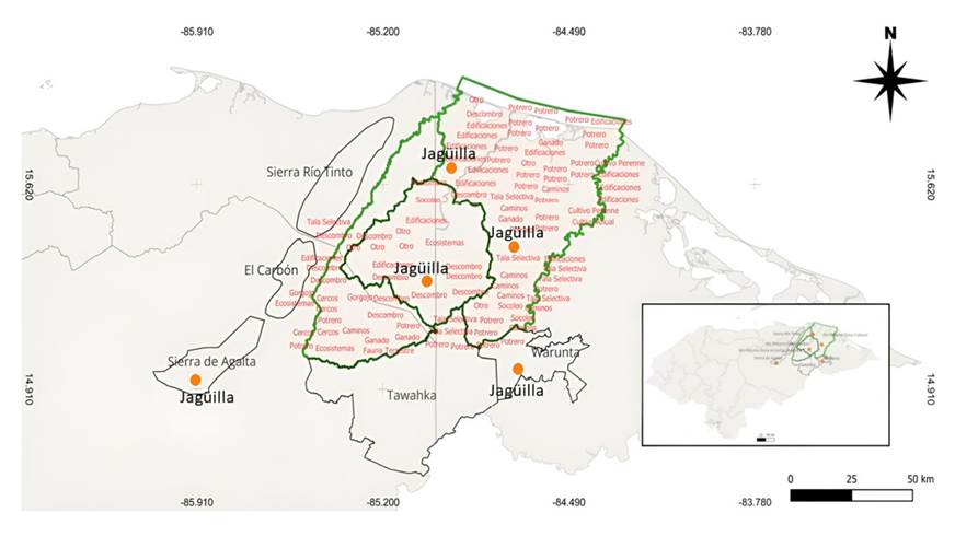
Figure 1 RHBRP, showing the three zones (ZN, ZC, ZA) with anthropogenic activities that are putting pressure on the stability of jagüilla populations. These activities include hunting, deforestation for cattle ranching, selective logging of mahogany, road construction, and infrastructure for ranches, among others. Similarly, the protected areas of Sierra de Agalta NP and the region in the Warunta Mountains have recently recorded jagüillas (Ssource: WCS 2023).
Results
In the RHBRP, jaguillas were registered in two of the three zones. In the core zone and the cultural zone, but not in the buffer zone. In these localities, thanks to biological monitoring using camera traps, groups of 2 to 45 individuals were recorded (Larsen 2019; Martínez et al. 2022).
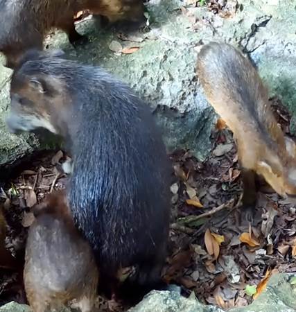
An important finding is the record of four individuals of jagüilla (Figure 2), a female and her three offsprings in Sierra de Agalta NP, municipality of Gualaco, department of Olancho; mentioning the relevance of these records as an opportunity for the conservation of this species.
Table 1 Results of jagüilla records in the RBHRP, this being the area of greatest importance for jagüilla, as it contains the largest records (Larsen 2019; Martínez et al. 2022).
| Year | Species | Site | Registration | Source |
|---|---|---|---|---|
| 2012 | Tayassu pecari | ZA RHBRP | 1 ind | report, ICF |
| 2016 | Tayassu pecari | ZC RHBRP | 2 ind | report, ICF |
| 2017 | Tayassu pecari | ZC RHBRP | 2 ind | report, ICF |
| 2019 | Tayassu pecari | ZN RHBRP | 2 ind | report, ICF |
| 2019 | Tayassu pecari | ZC RHBRP | 6 ind | report, ICF |
| 2019 | Tayassu pecari | ZN RHBRP | 16 ind | Larsen, H |
| 2019 | Tayassu pecari | ZN RHBRP | 3 ind | report, ICF |
| 2020 | Tayassu pecari | ZC RHBRP | 6 to 12 ind | report, ICF |
| 2021 | Tayassu pecari | ZN RHBRP | 1 ind | report, ICF |
| 2021 | Tayassu pecari | ZN RHBRP | 45 ind | report, ICF |
| 2021 | Tayassu pecari | Warunta | 50 ind | One Earth Conservation |
| 2022 | Tayassu pecari | Warunta | 100 ind | One Earth Conservation |
| 2022 | Tayassu pecari | PN Agalta | 4 ind | INCEBIO com. pers. |
For the Warunta region in the FINZMOS territory, tracks were observed, and photographic evidence was taken of a large group of approximately 50 to 100 individuals moving in this broadleaf forest territory. In different incursions in the years 2021, 2022, and 2023, local people have recorded the presence of many tracks on roads built by the movement of jagüilla troops.
Discussion
According to the potential distribution carried out by Portillo and Elvir (2016), the jagüilla distribution range was projected for the Moskitia region, specifically for the RHBRP, RB Tawahka, the Mocorón region, Rus Rus and Warunta. However, the total forest loss in the RHBRP in the last 23 years has been 87,212 ha; in the core zone 1,457 ha, in the buffer zone 31,168 ha and in the cultural zone 20,260 ha. For the Tawahka BR, the loss is 34,327 ha (WCS 2023). Similarly, forest loss in the eastern region (Warunta, Mocorón and Rus Rus) of the Moskitia in the eastern region is approximately 3,000 ha (Portillo and Hernández 2011; Portillo and Elvir 2016). Land use change has had an impact on jagüilla populations, as shown by biological monitoring reports for each zone of the RHBRP, Rus Rus Rus indigenous territory, and the Warunta Mountains. Even though specific monitoring has not been developed for the species, the evidence of forest loss and anthropogenic activities monitored in the RHBRP, and replicated in the rest of the Moskitia PAs, leads us to assume the negative impact on jagüilla populations throughout this region, considerably reducing spaces for reproduction, feeding and shelter (WCS 2023). The Warunta Mountains is the second site with the largest records of a troop of approximately 100 individuals, so it should be considered as one of the high priority sites for conservation. (Figure 3).
One of the important aspects of this work is to highlight the importance of Sierra de Agalta NP as a potential site for future research efforts, biological monitoring, patrols and operations for the development of conservation processes for the jagüilla as a conservation target of the park (Figure 2), since the last records of this species were recorded at the Quebrada del Sol site in Sierra de Agalta NP in 1994 (Marineros and Martínez 1998). Based on the above information, it could be assumed that a population was disaggregated in Sierra de Agalta NP, moving along an altitudinal gradient from 1,200 masl to 2,000 masl, moving between submontane evergreen tropical forest, montane and lower montane ecosystems. There may also be small groups of jagüilla within the declared protected area "Pech" Montaña El Carbón Anthropological and Forest Reserve and the proposed protected area Sierra del Río Tinto National Park, because the distances between the core zone of the RHBRP and Sierra del Río Tinto National Park is between 15 to 20 linear km, and the Anthropological and Forestry Reserve 'Pech Montaña El Carbon' and the proposed protected area Sierra del Rio Tinto National Park are part of the same mountainous continuum, but these protected areas do not appear in the modeling of the potential distribution of Tayassu pecari (Portillo and Elvir 2016).
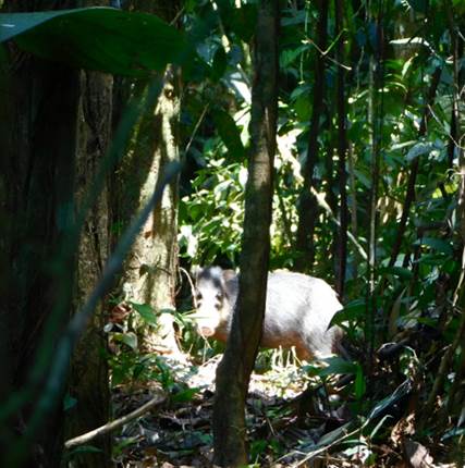
Figure 3 An adult jagüillas recorded in the Warunta Mountains, in the tropical evergreen lowland broadleaf evergreen forest, in the FINZMOS territorial council (photo by Wesly Lacuth).
It is of utmost importance to establish biological monitoring, patrols, and participatory conservation processes with the Miskito communities in the RHBRP, Warunta Mountains and with the local communities of Sierra de Agalta NP in order to know the conservation status of the jagüilla groups, to recover and stabilize the populations in these sites. It is a priority to protect and conserve the four sites mentioned in this work, one of them RHBRP, a World Heritage Site, in order to maintain the last registered populations of Tayassu pecari for Honduras, a species that is critically endangered in the IUCN red list for Honduras, with a strong perspective to become extinct in the coming years, if the necessary corrective measures for conservation and protection are not taken.

