


 nueva página del texto (beta)
 Inglés (pdf)
 Artículo en XML
 Referencias del artículo
 Enviar artículo por email
 Citado por SciELO
  Similares en
SciELO
Similares en
SciELO 
 Permalink
Introduction
The ocelot (Leopardus pardalis) is a medium-sized tropical feline that ranges from northeastern Argentina, northern Paraguay, and southern Brazil north to southern Texas and northwest to southeastern Arizona (Grigione et al. 2007; Paviolo et al. 2015; Rorabaugh et al. 2020; Amador-Alcala et al. 2022). Ocelots in Sonora have been found in different habitats, including tropical deciduous forest, thornscrub, desert grassland, oak woodland, and pine-oak forest, avoiding the driest areas in the Sonoran Desert (Brown and López-González 2001; López-González et al. 2003; Rorabaugh et al. 2020; Amador-Alcala et al. 2022). The state has a diverse physiography, from the heights of the Sierra Madre Occidental (SMO) in eastern Sonora and the isolated mountains in northeastern Sonora westward to the western lowlands and the Gulf of California (Castillo-Gámez et al. 2010). The SMO reaches its northern limit in the Sierra de Huachinera in northeastern Sonora (30.25° N). There are 55 isolated Island Mountain ranges or complexes of several ranges (González-León 2010) connected by oak woodland corridors in the Madrean Archipelago or Sky Island Region in northeastern Sonora between the SMO and the Mogollon Rim in central Arizona (Van Devender et al. 2013a). These Sky Islands crowned with oak woodland or pine-oak forest emerge from lowland ‘seas’ or inter-montane valleys with desert grassland, tropical deciduous forest (Figures 1 A and B), or foothills thornscrub (Figures 1 C and D). The principal rivers of the state, including the Ríos Bavispe and Río Aros which at their junction forms the Río Yaqui, which together with Río Mayo, drain the Sierra Madre Occidental; Río Sonora drains the Sky Island Region and southeastern Arizona tributaries. All these rivers are dispersal corridors through much of Sonora to the Gulf of California. The primary river corridors for the northward dispersal of ocelots are the Río Bavispe in the east, the Río Sonora in west, the Ríos Cocóspera, San Pedro, and Santa Cruz near the Arizona border, the Río Cuchujaqui (affluent of the Rio El Fuerte) is a corridor between the southern areas of Sonora and the SMO. In Sonora this tropical cat lives in habitats that range from tropical in the southern to temperate in the eastern and northeastern parts of the state.
The ocelot is listed as a least concern species by the IUCN due to its wide distribution in America (Paviolo et al. 2015); as an endangered species in the United States (US Fish and Wildlife Service 2022. https://ecos.fws.gov/ecp/species/4474) due to its restricted distribution. In Mexico, it is also listed as endangered “En Peligro” status under NOM-059-ECOL-2010, the Mexican endangered species law (López-González et al. 2003; Castillo-Gámez et al. 2010; Avila-Villegas and Lamberton-Moreno 2013; Gómez-Ramírez et al. 2017). Brown and López-González (2001) and López-González et al. (2003) reported ocelots from 28 localities in Sonora. Ocelots are rare in Arizona, with only six individuals seen between 2009 and 2021 (Culver 2016; Sabra Tonn, pers. comm. 2018). Apparently occasional ocelots reach Arizona from the Sonoran populations.
Interest in the current distribution and abundance of ocelots in Sonora was stimulated by the study of López-González et al. (2003) that presented a model of the ocelot distribution in Sonora, enhancing the understanding of their distribution in a variety of different habitats and relationship with the vegetation. The Project WILDCAT (PW) wildlife camera study in the lower Rio Bavispe Valley south of Granados (Figure 1D) just north of the Northern Jaguar Reserve (Gómez-Ramírez et al. 2017) and south of Nácori Chico yielded additional information on the general distribution of ocelots in Sonora. From 2015 to 2021, ocelots were photographed 180 times at 21 localities on six PW ranches. From 2016 to 2021, ocelots were photographed in Greater Good Charities’ (GGC) Madrean Discovery Expedition Wildlife project at 20 localities in the Sierras Alacrán, Aurora, Batamote, Huachinera, and Pajarito, and Rancho Chairababi near Cucurpe, Ranchos Pino Seco and San Manuel near Nacozari de García, and Ranchos Peñascal and Las Playitas near Bacoachi. Other projects that are currently going on in several areas of Sonora and have also provided records of ocelots as in the upper Bavispe, in Sierra de Huachinera and near Bacanora.
López-González et al. (2003) reported on a kitten from near Rosario de Tesopaco in southern Sonora. A female with a kitten was photographed on Rancho El Aribabi in February 2011 (Avila-Villegas and Lamberton-Moreno 2013; Rorabaugh et al. 2020). Here we report females with kittens photographed during Project WILDCAT on Rancho Carrizal (29.651° N) in January 2018 and three times in two localities on Pueblo Viejo (29.628° N) in November 2016 and May and November 2018 (Figure 4D). Breeding likely also occurs in the Nácori Chico area (29.419 to 29.479° N) as 21 images in nine widely spaced localities is too many for wandering individuals. Our goals are to summarize the distribution of ocelots in Sonora and analyze the relationships of vegetation type, the amount of rainfall, and altitude on distribution.
Previous mammal studies mention ocelots in Sonora. Ocelots are not specifically mentioned in Ignaz Pfefferkorn’s (2008) descriptive accounts of Sonora around 1756 to 1767 but were somehow mixed in with the description of bobcats (Lynx rufus). Burt (1938) reported ocelots at Güirocoba, south of Álamos. William Caire’s 1978 doctoral dissertation at the University of New Mexico on “The Distribution and Zoogeography of Mammals of Sonora, Mexico” mentions only two ocelot specimens from southern Sonora but gives a map of its probable distribution that reaches Arizona. His state of Sonora mammal checklist (Caire 1997) and doctoral dissertation publication (Caire 2019) also mentioned those records. A list of mammals in Schwalbe and Lowe (2000) on the amphibian and reptiles of the Sierra de Álamos region in southern Sonora included ocelots. Several ocelot records are mentioned in Brown and López-González (2001). López-González et al. (2003) reported early accounts of hunting of ocelots in Sonora and other records of the species, these authors summarized the distribution of ocelots in Sonora and included a Genetic Algorithm for Rule Set Production (GARP) model of their distribution. Ceballos and Oliva (2005) presented limited descriptions of Sonoran mammal species, including the distribution of ocelots. Castillo-Gámez et al. (2010) presented an updated ocelot distribution in Sonora mostly based on López-González et al. (2003) with several new records. Avila-Villegas and Lamberton-Moreno (2013) documented ocelots in oak woodland at Rancho El Aribabi, including the northernmost breeding population in Sonora. Coronel-Arellano et al. (2016) reported a camera image of an ocelot from the Sierra Los Ajos. Gómez-Ramírez et al. (2017) documented 33 individual ocelots on the Northern Jaguar Reserve and calculated their survival and density. Rorabaugh et al. (2020) on Rancho El Aribabi and Amador-Alcala et al. (2022) on Northern Jaguar Reserve discussed the ecology of ocelots, based on photographs obtained with camera traps.
Materials and methods
We analyzed 149 recent records of Sonoran ocelots compiled from wildlife camera and track studies in Sonora, including the Reserva Monte Mojino near Álamos (Figure 1B); the Sierra de Álamos; in the lower Río Bavispe Valley (Project WILDCAT) and south of Nácori Chico (Figure 1E); Madrean Discovery Expedition Wildlife cameras in the Sierras Alacrán (Figure 2B), Aurora, Batamote, Huachinera, and Pajarito (Figure 1F); Ranchos Peñascal and Las Playitas near Bacoachi, Ranchos Pino Seco and San Manuel near Nacozari de García, and Rancho Chairababi near Cucurpe; Universidad de la Sierra study areas near Moctezuma; CIAD-Guaymas study at Rancho Bamochi, Rancho Agua Caliente at Huachinera, Rancho Teiserobabi, and Rancho La Joya near Bacanora; other ranchos near Ures; near Santa Ana west of Yécora; Sierras Los Ajos Buenos Aires, and La Madera in APFF Bavispe; Rancho El Aribabi (Figure 2A) and the Río Cocóspera in Sierra Azul; and Cajón Bonito (Figure 2C) near the Arizona border. No camera traps were set up for ocelot distribution in areas where ocelots have never been reported like the dry western part of Sonora with a Sonoran desertscrub vegetation i. e. Hermosillo, Caborca, San Luis Río Colorado or at Desierto de Altar.
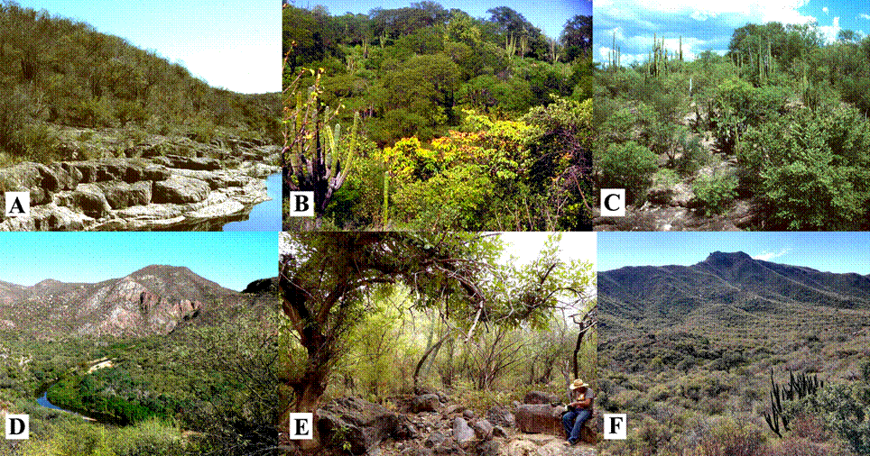
Figure 1 Tropical ocelot habitats in Sonora. A. Tropical deciduous forest along the Río Cuchujaqui east of Álamos. January 1984 (Photo T. R. Van Devender). B. Tropical deciduous forest near Álamos. Summer 1991. Hecho cacti (Pachycereus pecten-aboriginum) are prominent (Photo M. A. Dimmitt). C. Foothills thornscrub near Curea. September 1998. Organ pipe cacti/pitahaya (Stenocereus thurberi) are common (Photo T. R. Van Devender). D. Foothills thornscrub above the Río Bavispe on Rancho Pueblo Viejo east of Divisaderos. November 2016 (Photo T. R. Van Devender). E. J. M. Galaz-Galaz checking wildlife camera in foothills thornscrub on Rancho Pueblo Viejo. November 2016 (Photo A. L. Reina-Guerrero). F. Foothills thornscrub at Puerta del Sol, Sierra Pajarito east of Ures. November 2018. Visible on lower right are an organ pipe cactus and a fish poison tree/palo blanco (Piscidia mollis gray leaves) (Photo N. L. Villanueva-Gutiérrez).
Previous 28 ocelot records in Brown and López-González (2001) and López-González et al. (2003) were added to the Madrean Archipelago Biodiversity Assessment (MABA) database (accessible in the Madrean Discovery Expeditions [MDE] database). They were also used for this study. All the recent ocelot records and images in the present study are publicly available online in the MDE database (madreandiscovery.org). The Bavispe APFF monitoring records are in the Bavispe Flora and Fauna Protected Area database (accessible in the MDE database). And a single record from UNISIERRA database (http://csvcoll.org/portal/collections/harvestparams.php).
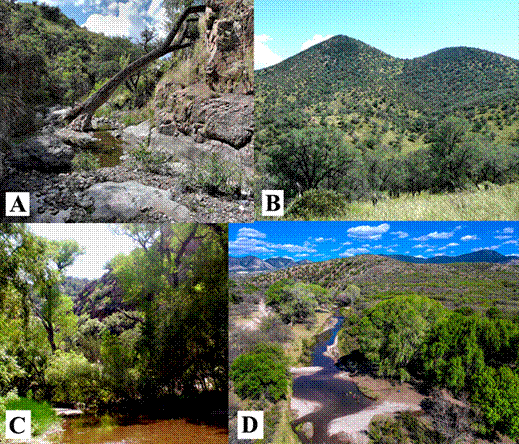
Figure 2 Temperate ocelot habitats in Sonora. A. Rocky stream canyon in oak woodland. Arroyo Las Palomas, Rancho El Aribabi, Sierra Azul, east-northeast of Ímuris. October 2015 (Photo J. C. Rorabaugh). B. Oak woodland dominated by Arizona white and Mexican blue oaks (Quercus arizonica, Q. oblongifolia). Sierra Alacrán southeast of Cananea. September 2018 (Photo A. L. Reina-Guerrero). C. Cottonwood-willow (Populus fremontii-Salix spp.) riparian deciduous forest, desert grassland on slopes. Cajón Bonito, Rancho los Ojos Calientes east of Agua Prieta. August 2007 (Photo T. R. Van Devender). D. Cottonwood-willow riparian gallery forest along Río Santa Cruz in desert grassland. Aerial view to the north of Paseo del Cajón northeast of San Lázaro. April 2019. Only 18 km south of the border, this is a likely corridor for ocelots to the Huachuca Mountains in Arizona (Photo L. Gutiérrez, NortePhoto, Inc).
Camera traps of different make were set either to take still photographs or in video mode; the majority of the cameras were set at an altitude of 70 to 100 cm, above ground, some of them were baited with a sardine-tomato mixture, some others were not baited and set in areas where other species were the objective, i. e. neotropical otters (Lontra longicaudis) in riparian habitats (Gallo-Reynoso et al. 2019). More than 100 places were used for the monitoring of ocelots, each site had a camera trap (to complete that number several cameras were moved to different locations along the study time), camera traps were set for the record of multiple species in most of the ranches and natural protected areas in which they were used for monitoring wildlife, ocelot records were extracted from those monitoring efforts.
We analyzed the frequency of observations effect of precipitation, vegetation type, and altitude on the distribution of L. pardalis in Sonora, the data set used for this analyzes comprised 175 out of 177 records that were complete having the four variables, of which we removed two duplicated records (curtailing the effect of multiple records produced by any camera trap). Original data were obtained from GPS location records with notes on the surrounding vegetation type in each one of the records. Precipitation was obtained from Gallo-Reynoso et al. (2018) armadillo (Dasypus novemcinctus) distribution in Sonora by superposing location data of Ocelots on the precipitation/ vegetation type SIG data of Sonora.
Results
The distribution of ocelot in Sonora is complex as shown by the distribution of the 175 records considered herein (Figure 3). These records represent five years (2015 to 2021) of camera trap studies, and 28 previous records of ocelots in Sonora (Brown and López-González 2001; López-González et al. 2003). Ocelots occur in the eastern half of Sonora, generally avoiding lower areas with less than 400 mm of annual rainfall and the arid Sonoran Desert, therefore records were found in the southeastern, central, and northeastern part of the state. There are 72 municipalities in Sonora, and ocelots have been documented in 28 of them: Agua Prieta, Álamos, Arizpe, Bacadéhuachi, Bacanora, Bacoachi, Cajeme, Cananea, Cucurpe, Cumpas, Divisaderos, Fronteras, Granados, Huachinera, Huásabas, Ímuris, Moctezuma, Nácori Chico, Nacozari de García, Navojoa, Quiriego, Rosario de Tesopaco, Sahuaripa, San Pedro de la Cueva, Soyopa, Suaqui Grande, Tepache, Ures, and Yécora. Ocelots are likely present in another 22 municipalities in southern and eastern Sonora.
Ocelot distribution in the study area were obtained on mean altitude above sea level (m) of 840 m (± 458 m, range: 53 to 2,151 m), its modal distribution was 1,326 m, although denoting some preference for higher areas over lower ones with 93 (53.1 %) occurrences in areas higher than 1,000 m, and with 82 (46.9 %) occurrences below 1,000 m. Their distribution on Sonora is affected by the amount of rainfall in the different areas of central and eastern Sonora, preferring areas with a mean of 515 mm of rain (± 107 mm, range: 400 to 800 mm), modal distribution was found at 500 mm of rain. No record was obtained in less than 400 mm of rain in the area occupied by Sonoran desertscrub (Figure 3). The areas preferentially occupied by ocelots in Sonora had different frequencies of occurrence related to the amount of rain (mm), 43 occurrences (24.6 %) between 400 to 499 mm of rain; 81 occurrences (46.3 %) between 500 to 599 mm of rain; 21 occurrences (12 %) between 600 to 699 mm of rain; 25 occurrences (14.3 %) between 700 to 799 mm of rain; there were only 5 occurrences (2.8 %) above 800 mm of rain, there were no records below 400 mm of rain.
Ocelots occur in tropical deciduous forest and foothills thornscrub in the southern Sonora (Figure 1 B and C) and desert grassland, oak woodland, and pine-oak forest in the east and northeast (Figure 2 B). The vegetation in which Ocelots occurred preferentially was Sierra Madrean woodlands and forests with 86 (49.1 %) occurrences, followed by foothills thornscrub with 47 (26.9 %) occurrences, tropical deciduous forest with 32 (18.3 %), grasslands / Chihuahuan desertscrub with 7 (4 %) occurrences and by Sonoran desertscrub with 3 (1.7 %) occurrences (Figure 1F).
Ocelots are commonly photographed in foothills thornscrub habitats at localities in the lower Río Bavispe Valley (Figure 1 A, B and D). Ocelots are also photographed with regularity as far north as Rancho El Aribabi in the Sierra Azul in oak woodland (Figure 2 A and B; Figure 4 E and F) and along the Río Cocóspera (30.856° N) in riparian habitats. Additionally, ocelots shift from tropical lowland habitats into upland desert grassland, oak woodland, and pine-oak forest north of the Neotropics. Ocelots have been recorded from 53 to 2,151 m (average 840 m) in Sonora but are not expected to be found near sea level in the southern coastal areas. Ocelots probably use riparian habitats to disperse between areas and vegetation types.
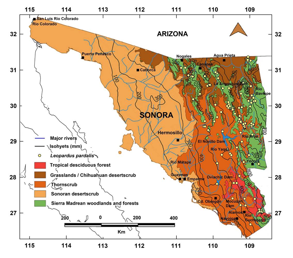
Figure 3 Distribution of ocelot records in Sonora and their occurrence in different vegetation types. Areas with a precipitation less than 400 mm are not occupied by ocelots, unless they occupy riparian habitats adjacent to canyons and rivers. Inter-montane valleys and riparian habitats are widely used for ocelot dispersal corridors.
Comparison by frequency analysis shows that precipitation above 400 mm (n = 132) explained the 75.4 % of the presence of Ocelots in Sonora. Vegetation type (Sierramadrean woodlands and forests (n = 86) explained the 49 %. Elevation above 800 m (n = 109) explained the 62.3 % of occurrences. Therefore, a combination of precipitation-elevation-vegetation type were the variables that defined the presence and distribution of Ocelots in Sonora (Figure 5). Unaccounted variables such as seasonality might also be important for the presence and distribution of Ocelots in Sonora but was not analyzed in this study.
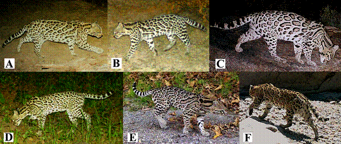
Figure 4 Ocelot images at different places. A. Arroyo Las Palomas 28 km ENE Ímuris November 2015 (Photo by J. C. Rorabaugh). B. Rancho Hoyo, Arroyo Bacadéhuachi east of Divisaderos. February 2016 (Photo by J. M. Galaz-Galaz). C. Puerta del Sol, Sierra Pajarito east of Ures, April 2019 (Photo by J. M. Cirett-Galván). D. Rancho Los Pescados south-southeast of Nácori Chico, August 2018 (Photo by J. M. Galaz-Galaz). E. Female with kitten. Pozo del Indio, Rancho Pueblo Viejo, November 2015 (Photo by J. M. Galaz-Galaz).
Discussion
The distribution of ocelot records is much wider than expected and occupies more geographic area than predicted by the GARP analysis in López-González et al. (2003), mostly based on tropical deciduous forest and thornscrub. Our records still fall inside the predicted area in their southern distribution but extend in other regions not reported previously that include several vegetation types such as desert grassland, oak woodland, and pine-oak forest to the north and northeast. The distribution of ocelots in Sonora follows the distribution of precipitation, similar to what has been demonstrated with armadillos in Sonora (Gallo-Reynoso et al. 2018).
There are still some gaps in their distribution in more remote areas in Sonora, where it needs to develop field surveys and assessment with the use of wildlife cameras. Also, ocelots are expected to occur in tropical deciduous forest in the foothills of the Sierra Madre Occidental from the Sinaloa border north through the Álamos area north to Yécora. Ocelots are also likely to occur in foothills thornscrub along the Río Yaqui from Ónavas to Tónichi north to San Felipe de la Cueva, Sahuaripa, and Mátape. They are also expected in foothills thornscrub in the Río Sonora Valley from the Sierra Aurora north to the Sierras Aconchi and Los Locos and to the Rancho El Charababi area just south of the Sierra Azul. To the west, they are likely to be in foothills thornscrub in the Sierra Bacatete east of Guaymas on Yaqui First Nation land, Sierra El Aguaje corridor to Sierra Libre north of Guaymas where an intermittent creek bears the name of “El Ocelote”, between Guaymas and Hermosillo. Considering the records of ocelots in Arizona, they likely also occur in Sonora close to the Arizona border in the Sierras Las Avispas, Chivato, Pinito, and San Antonio. Note that our report does not include recent records from the Northern Jaguar Reserve, although Gómez-Ramírez et al. (2017) reported 381 wildlife camera images of which 33 were individually identified ocelots during 2010-2012, and Amador-Alcalá et al. (2022) reported ocelot abundance and home range based in 54 camera traps stations, obtaining 135 photographic records of which 17 were individually identified ocelots during 2015.
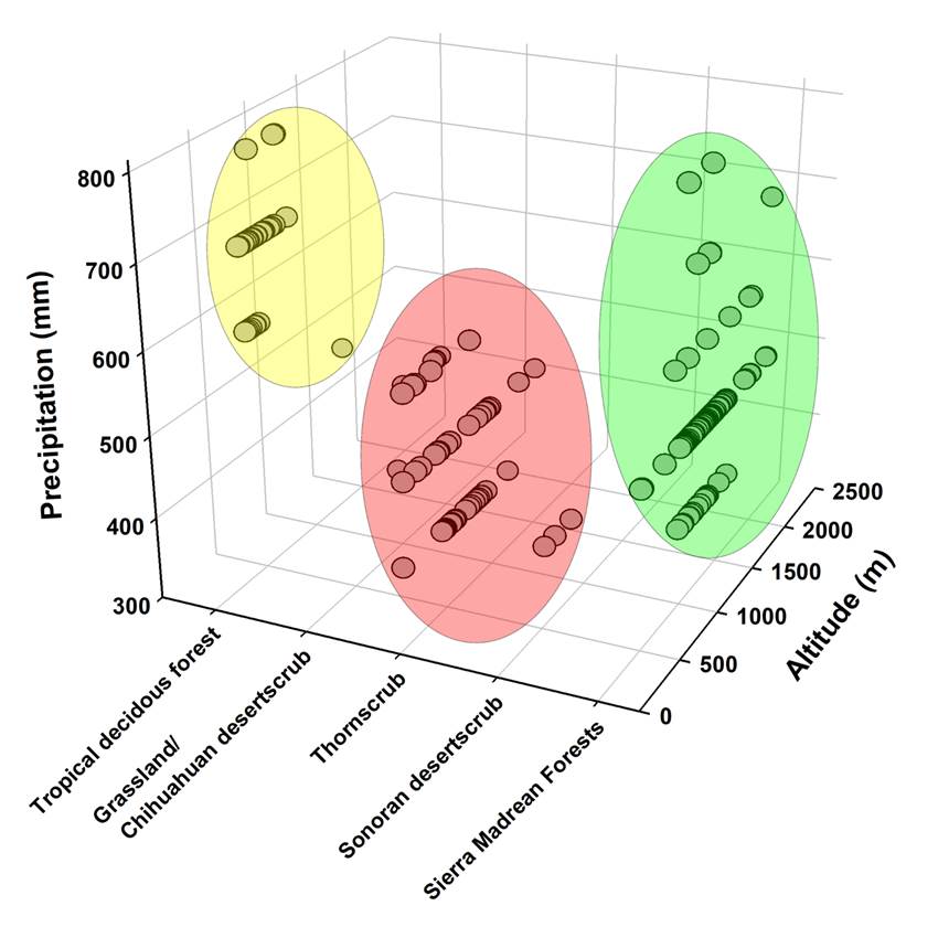
Figure 5 Influence of the vegetation type, rainfall, and elevation on the distribution frequency of Leopardus pardalis in Sonora. Vegetation types: Sierramadrean forests with 86 occurrences (49.1 %), Sonoran Thornscrub and desertscrub (Chihuahuan and Sonoran) with 57 occurrences (32.6 %), and tropical deciduous forest with 32 occurrences (18.3 %) were the type of vegetation more frequented by ocelots. Precipitation above 400 mm accounted for 132 occurrences (75.4 %), and 43 records in precipitation between 300 to 400 mm (24.6 %). Elevations from 800 to 2,200 m accounted for 109 records (62.3 %), 52 occurrences in elevations between 400 to 800 m (29.7 %) and 14 records in elevations less than 400 m (8 %).
Ocelots are present in the northernmost area of the SMO in the Sierra Huachinera. There is an observation of an individual in the SMO from the Río Maycoba east of Yécora near the Chihuahua border. Probably ocelots use riparian corridors to reach higher areas of the Sierra Madre Occidental, similar to a nine-banded armadillo (D. novemcinctus) record from Los Pilares in a nearby locality (Gallo-Reynoso et al. 2018) likely reached the area from tropical vegetation in the Río Mayo drainage near Moris, Chihuahua (36 km to the southeast), a route likely followed by ocelots. Wildlife camera-trap surveys in pine-oak forest in the Mesa Tres Ríos area in Sonora near the Chihuahua border were carried out in 2018 but did not find ocelots. López-González et al. (2015) added ocelots to the fauna of the SMO in Chihuahua based on a wildlife camera study on oak woodland east of Nuevo Casas Grandes. The extent of the ocelot distribution in the Sierra Madre Occidental (SMO) needs further detailed study.
Biogeography. Four different biotic provinces merge in the Madrean Archipelago in northeastern Sonora and southeastern Arizona - the Rocky Mountains, California Mediterranean, Great Plains/Chihuahuan Desert, and Sierra Madre Occidental, and there is also the transition zone between the Nearctic, and Neotropical Biogeographic regions (Van Devender et al. 2013a). Although the Tropic of Cancer (23.43° N) just north of Mazatlán, Sinaloa is often considered the northern limit of the New World Tropics, tropical deciduous forest extends 680 km to the northwest to the Sierra San Javier, Sonora (28.62° N; Van Devender et al. 2013a). The transition between the Neotropical and Nearctic provinces starts in Sonora. In southern Sonora, coastal thornscrub is transitional between tropical deciduous forest (Figure 1, A and B) and Sonoran desertscrub, and in central Sonora foothills thornscrub (Figure 1, C and D) is between Sonoran desertscrub and oak woodland. The northernmost thornscrub in Sonora is found near Arizpe in the Río Sonora Valley (30.35° N) and at Presa La Angostura on the Río Bavispe (30.44° N; Van Devender et al. 2013b). At its northern edge where thornscrub transitions into desert grassland, it is limited by freezing temperatures during fall - winter.
The distribution of ocelot in Sonora reflects the effect of precipitation and vegetation types mentioned above but does not occur in desertscrub in the Sonoran Desert. In Sonora, ocelots occur in areas with 400 mm or greater annual precipitation, unless they are in riparian habitats adjacent to canyons and rivers. Inter-montane valleys in this precipitation range regardless of their vegetation type are also occupied by ocelots, meaning that these riparian habitats are widely used for ocelot dispersal (Figure 2 C and D).
Many tropical species reach their northern distributional limits in desert grassland and oak woodland in northern Sonora or southern Arizona (Van Devender et al. 1994). Examples include Neotropical reptiles such as vine snake/bejuquillo (Oxybelis aeneus), and thornscrub hooknose snake (Gyalopion quadrangulare); and Neotropical plants such as coralbean/chilicote (Erythrina flabelliformis), and kidneywood/palo dulce (Eysenhardtia orthocarpa). The latitudinal wedge effect caused by increasing aridity at lower elevations and colder temperatures at higher elevations is a general biogeographic pattern in the western half of the continent. Neotropical otter (Lontra longicaudis; Gallo-Reynoso et al. 2019), Jaguar (Panthera onca), ocelot (L. pardalis), coati/cholugo (Nasua narica), collared peccary/ cochi jabalí (Pecari tajacu), Sonoran possum/ tlacuache (Didelphis virginiana californica; Babb et al. 2004) and nine-banded armadillo D. novemcinctus (Gallo-Reynoso et al. 2018) are Sonoran mammals that fit this pattern.
Foothills thornscrub in the Granados-Divisaderos area in the lower Río Bavispe Valley and the Bacadéhuachi-Nácori Chico area to the east, and the Río Sonora to the west are likely the sources for ocelots dispersing to the mountains of northern Sonora e. g., Sierras Huachinera, Buenos Aires, de Los Ajos, and Azul. From these areas, ocelots disperse into some areas of southeastern Arizona, including the Huachuca, Pajaritos, Santa Rita, and Whetstone Mountains (Culver 2016).
One important result of this study is the documentation of the use of riparian habitats by ocelots. River corridors for northward dispersal of ocelots are likely the Río Bavispe in the east, the Río Sonora in the west, the Río Mátape in the center, the Río Mayo and Río Cuchujaqui in the south, and Ríos Cocóspera, San Pedro, and Santa Cruz (Figure 2 D) near the Arizona border. However, considering that ocelots primarily live in tropical habitats in southern Sonora, habitat connectivity is more important than river corridors. They will likely thrive unless there is drastic habitat loss or unavailable prey. In northeastern Sonora where foothills thornscrub merges into desert grassland and ocelots move up into woodlands, river corridors are likely more important for their dispersal.
Near the Arizona border, ocelots are found in oak woodland in the Sierras Alacrán, Avispas, and Azul but were not found in the Sierra Chivato close to the border with Arizona, USA. In 1964, Sewell Goodwin killed an ocelot at 2,583 m elevation in a pine tree on the summit of Pat Scott Peak in the Huachuca Mountains, Arizona (Brown and López-González 2001). Recently, an ocelot was seen in the Huachuca Mountains in Arizona (A. Niels, pers. comm, 2021), it is probable that the ocelot dispersed from Sierra Chivato 35 km southwest of where the southern end of the Huachuca Mountains reaches the border. It is also possible that ocelots use the Río Santa Cruz as a dispersal corridor north into the San Rafael Valley or at Sierra El Pinito (not yet studied with camera-traps), near there are the Patagonia Mountains, a northern extension of the Sierra El Pinito and just south of the Santa Rita Mountains. The Canelo Hills at the north end of the San Rafael Valley is a woodland corridor between the Patagonia Mountains and the Huachuca Mountains to the east used by ocelots. The ocelot population in the Rancho Las Playitas area near Bacoachi, indicates that ocelots also live in desert grassland in the valley between the Sierra Azul and the Arizona mountains.
This remarkable connectivity of ocelot habitat depending on factors such as precipitation, vegetation type and elevation should be protected as corridors for the benefit of ocelots and other tropical Mexican endangered species such as jaguar (P. onca) that as well as ocelots reach their northern distribution limits in America in Sonora and/or southern Arizona.
T. R. Van Devender. Concept, data acquisition, compilation, and analyses, writing, reviewing, field work, fund acquisition. J. P. Gallo-Reynoso. Concept, writing, reviewing, data acquisition, compilation and analyses, mapping, field work, fund acquisition. J. C. Rorabaugh, data contribution and analyses, field work, reviewing. J. M. Cirett-Galán. N. L. Villanueva-Gutiérrez. G. Molina-Padilla. L. Lozano-Angulo. J. M. Galaz-Galaz. S. A. Amador-Alcalá. H. Silva-Kurumiya. F. I. Ochoa-Gutiérrez. J Schipper. M. de la P. Montañez-Armenta. G. Yanes-Arvayo. M. L. Acedo-Aguirre. R. E. Jimenez-Maldonado. R. W. Harrill, I. D. Barba-Acuña, and J. Égido-Villarreal, participated in fieldwork, camera trap settings, photo/video selection and data compilation.

