




 nueva página del texto (beta)
 Inglés (pdf)
 Artículo en XML
 Referencias del artículo
 Traducción automática
 Enviar artículo por email
 Citado por SciELO
  Similares en
SciELO
Similares en
SciELO 
 Permalink
1 Introduction
Understanding tourist flow dynamics is crucial for decision-making authorities in strategic tourism policy planning, infrastructure development, and natural resource management. This data enables informed decision-making to develop a sustainable tourism industry, promoting economic benefits while minimizing negative impacts on destinations.
However, the primary challenge lies in collecting data that helps analyze and understand the behavior and flow of tourists in the area [22].
Similarly, given the importance of the afore-mentioned points, the city of Saltos del Guairá, Paraguay, whose economy partially depends on the flow of tourists from Brazil [2], faces the same difficulties due to the lack of a mechanism to obtain data for analyzing the tourist flow entering the city.
Additionally, there is a challenge in addressing the need for a local company, ”MP Sales S.A.”, to maintain a historical record of the number of vehicles entering its premises. This is to study the flow of its customers and implement better marketing strategies to attract more customers during periods of low tourist activity.
There are several approaches to addressing the described issue, as observed in Benkhard [3, 12]. One of these approaches is monitoring vehicular traffic in cities.
A review of the methods utilized for vehicle traffic monitoring is given in this respect by the research done by Jain et al. [11], with image processing using computer vision techniques standing out as a particularly useful approach.
Thórhallsdóttir et al. in [21] have proposed a method for analyzing the number and distribution of tourists in Iceland. Their data collection strategy relies primarily on magnetic radar-based vehicle counters. However, this method may present some additional challenges, such as the limited range of the radars for vehicle detection and the need for periodic radar calibration to ensure their correct operation.
At the national level, in Paraguay, efforts have been made for the implementation of traffic monitoring systems, although these have been mainly focused on road safety aspects [10].
Therefore, considering all of the above, the main objective of this work is the design and implementation of a vehicle counting system using image processing by means of pre-trained machine learning (ML) models for the analysis of tourist flow in the city of Saltos del Guairá.
The proposal seeks to provide an affordable solution that can be adapted to the needs of the city and its road infrastructure.
2 Methodology
This work focuses on the design and implementation of a specific technological system, in this case, a vehicle counting system. In addition, existing knowledge and methods are applied to solve this problem. Therefore, this work can be classified as an applied technology research. The processes followed are detailed as follows:
2.1 ML model comparison
The purpose of this phase is to identify the most appropriate pre-trained ML model for vehicle detection in the context of the developed project. The selected model will be implemented on a Jetson Nano™ [15]. This device is ideal for Edge Computing and Internet of Things (IoT) projects. It offers a Linux-based development environment, ideal for implementing AI solutions on embedded devices with limited resources.
Two pre-trained object detection models were compared: TrafficCamNet [16], based on Detect-Net_v2 [19], and YOLOv7-tiny, a compact and efficient version of YOLOv7 [23, 24]. Object tracking algorithms were integrated into both models.
Initially, trials were conducted with the Traffic-CamNet model, implemented through the use of the Jetson Inference library, which makes it easy to build and train AI models in Jetson based environments [8]. This library incorporates, by default, an object tracking algorithm using the IoU (Intersection over Union) metric [6]. But tests have also been carried out by integrating the SORT tracking algorithm (Simple Online and Realtime Tracking) [5].
Similar tests was conducted using an optimized model based on YOLOv7-tiny but modified for execution using TensorRT [14]. This model was also integrated with the SORT tracking algorithm.
In order to determine the model to be used, the selection criteria to be considered were set out in the Table 1. In order to determine the performance of the models and meet the criteria C3 and C4, tests will be carried out using two separate pre-recorded videos.
Table 1 Machine learning model selection criteria
| ID | Criteria | Variable |
| C1 | Free license | License type |
| C2 | Must be optimized for the Jetson Nano™ without any further adjustments | Ease of implementation |
| C3 | Must allow smooth video processing, higher frames per second (FPS) | Inference speed |
| C4 | Must detect and identify as many vehicles as possible | Accuracy and precision |
2.2 Analysis and design
The system is composed of two main modules: the vehicle counter, developed and deployed at the Jetson Nano™, and a web application for the visualization and disclosure of data collected by the counter.
The functional requirements for the counter were defined based on the detection data that can be obtained from the selected ML model. The timestamp and location data were also recorded. Moreover, the requirements for the web application were established taking into account the data submitted by the counter, as well as the data transformations necessary for the graphical visualization of the number of vehicles counted.
The following artifacts were used to design the system:
2.3 Prototype building
The development process of the system was carried out using a methodology based on functionality-driven Development, as proposed in the work of Ruiz Diaz et al. [18]. This software development approach focuses on iterative delivery of functional features and includes several subprocesses, such as:
— Creation of repositories for the project.
— Definition of tasks for the implementation of functionalities.
— General tracking of the project through the review and integration of functionalities.
For the development of the vehicle counter, it was implemented within the Jetson Nano™ operating system itself, using the Python 3 programming language. As for the web application, the Laravel framework version 10 with PHP version 8 was used. In both cases, the data was stored using SQLite 3.
In parallel, the design and manufacture of the housing for the electronic components for the vehicle counter were carried out. The components are composed of a Jetson Nano™ minicomputer, a compatible camera, and others. Table 2 details the technical specifications of these components.
Table 2 Technical specifications of the prototype components
| Components | Technical information |
| Jetson Nano™ |
GPU: NVIDIA Maxwell™ architecture with 128 CUDA® cores CPU: Quad-core ARM® Cortex®-A57 MPCore processor Memoria RAM: 4 GB 64-bit LPDDR4 1600MHz - 25.6 GB/s Performance: 472 GFLOPs for running modern AI algorithms |
| High Quality Arducam Camera |
Resolution: 12.3 megapixels Optical Size: 1/2,3” Focal length: 6mm |
| Jetson Nano™ cooling fan |
Working voltage: 5V Connector: 4 pins Speed control: PWM |
| Power supply |
Input voltage: CA 100 120/200 240V 50 / 60HZ Output power: DC 5V 5A With high efficiency DC wave |
The manufacturing process of the casing involved modeling a 3D design of a structure to contain the equipment presented in Table 2. For this purpose, the open-source 3D modeling software FreeCAD version 0.21 was used [20]. The dimensions and technical specifications of the electronic components were considered in this process. The designed 3d model is available at https://github.com/FACITEC-INV/prototipoCarcaza.
Once the 3D model of the casing for the camera was obtained, it was printed on a 3D printer. The material used for printing was acrylonitrile butadiene styrene (ABS) filament, whose physical and thermal characteristics are suitable for this purpose [1].
2.4 Testing and deployment
During this stage, tests were conducted on both the vehicle counter and the web application. The constructed vehicle counting prototype will be installed at the main entrance of ”MP Sales S.A.”. At the selected location, it is possible to monitor the main access route for foreign tourists to the city of Saltos del Guairá.
The tests performed on the counter consisted of verifying the correct operation of the counting system, the integrity and persistence of the detection data, and the correct sending of the data to the web application server.
To carry out the tests on the counter, the Jetson Nano™ device was accessed remotely using VNC connections. It should be noted that for headless connections (without a physical screen), the use of an HDMI connection emulation device is necessary if you want to obtain an adequate screen resolution that can be adjusted.
For their part, the tests carried out on the web application included functionality tests of the exposed APIs and verification of the correct display of the data sent by the counter within the development environment.
Finally, the system deployment consisted of installing the vehicle counter and bringing the web application online.
3 Results
3.1 Evaluation of ML Models
As can be verified in the available documentation, both models meet the criterion of having free licenses. On the one hand, both the jetson-inference library project and the TrafficCamNet model are licensed under the MIT license type [8, 15]. This type of license allows free use of the software, even allowing modification and redistribution [17]. On the other hand, the YoloV7-tiny model is licensed under the GPL-3.0 license [24]. This type of open source licensing guarantees users the freedom to use, modify and distribute the software [9].
As for the optimization of the models for their use in the development environment used in this project, it can also be mentioned that both TrafficCamNet, implemented with Jetson Inference, and YoloV7-tiny, implemented with TensorRT, meet the criterion.
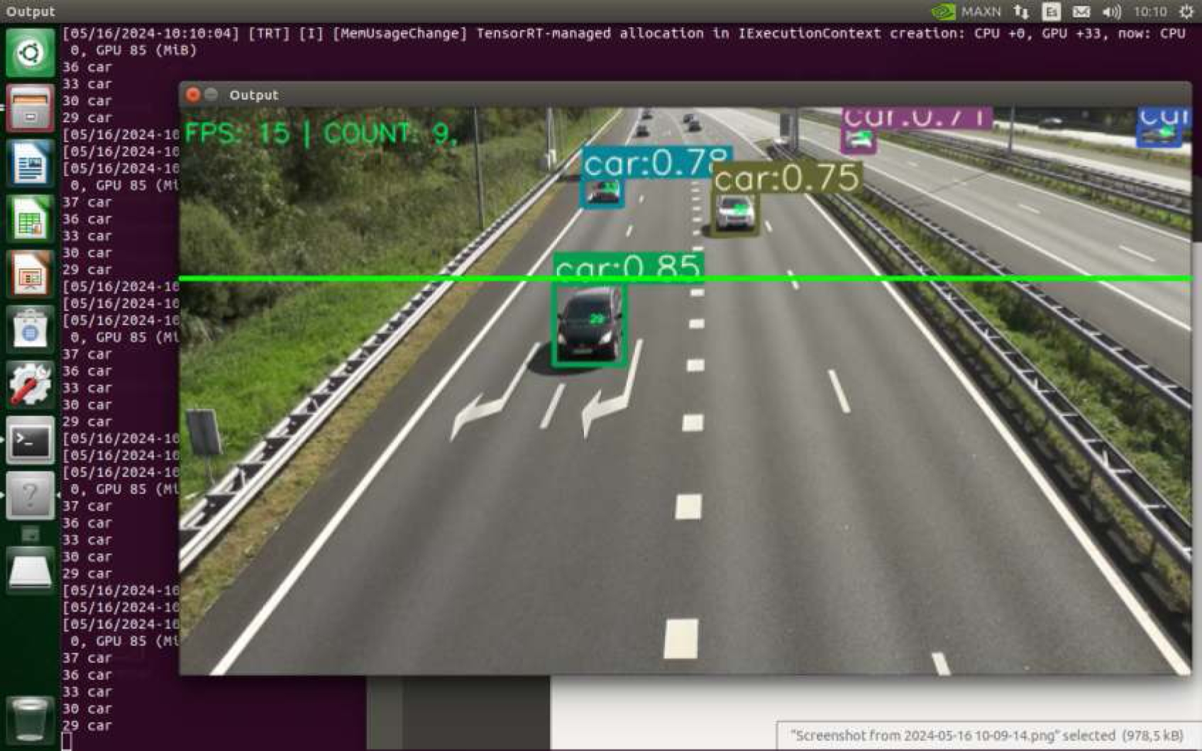
The jetson-inference library allows implementing various ML models in a simple and optimized way on Jenson devices, including the Jetson Nano™, as specified in the documentation [8]. As can be seen in Fig. 1, in the tests conducted with this library, it was possible to correctly implement object detection with the TrafficCamNet model.
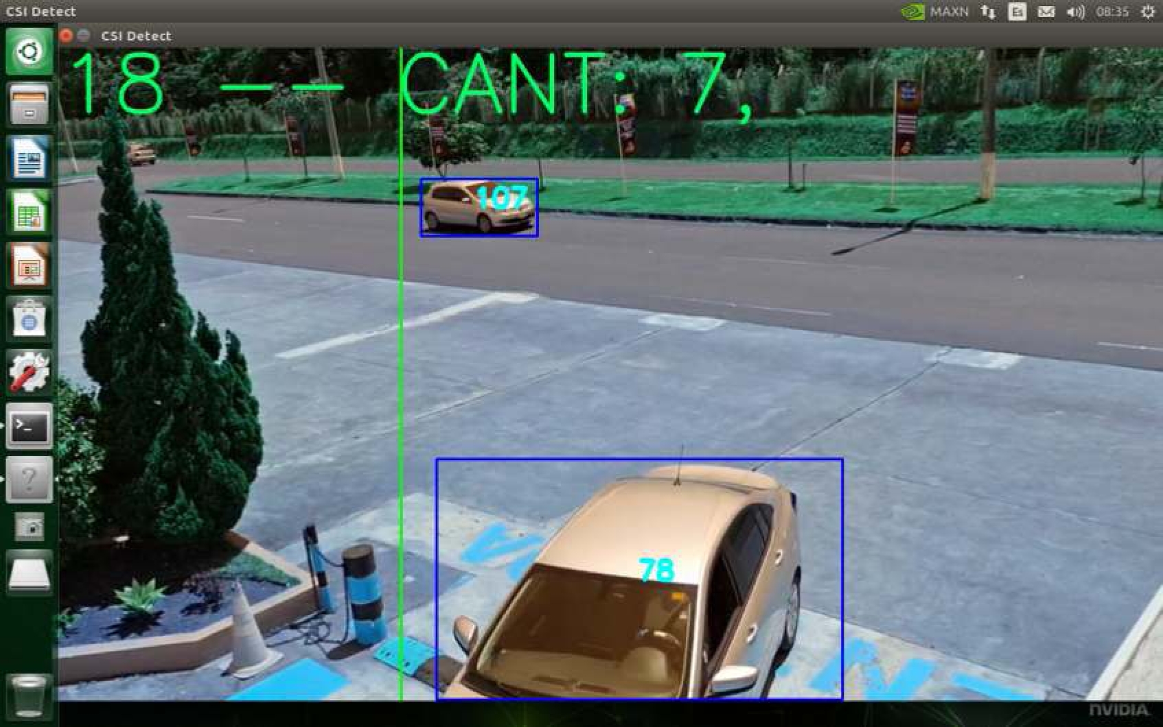
As mentioned by Nguyen et al. [13] with the use of TensorRT, it is possible to significantly improve the inference speeds of models such as YoloV7-tiny on equipment with limited computational resources, such as that used in this work. In Fig. 2, the detection tests performed with YoloV7-tiny for object detection on the Jetson Nano™ used in this project can be observed.
In the tests carried out, it was observed that both models achieved promising results in terms of inference speed, taking into account the resource restrictions of the Jetson Nano™. The TrafficCamNet model achieved an image processing rate of 18 FPS, while the YOLOv7-tiny model, implemented with TensorRT, reached a speed of 15 FPS. It should be noted that these values were obtained with the already integrated tracking algorithms. These results indicate that both models are capable of processing videos in real time with an acceptable level of efficiency.
As can be seen in Table 3, in the results obtained for vehicle counting, it can be observed that the YoloV7-tiny model integrated with the SORT detection algorithm obtained the best performance. In terms of detection algorithms, even in the tests performed with the TrafficCamNet model, the SORT algorithm obtained better results.
Table 3 Counting test results: percentage of vehicles counted
| Models | Video 1 | Video 2 |
| TrafficCamNet with jetson-inference tracking algorithm | 57% | 10% |
| TrafficCamNet with SORT tracking algo-rithm | 57% | 90% |
| YoloV7-tiny with SORT tracking algorithm | 100% | 90% |
In the tests carried out with the default tracking algorithm of jetson-inference, the vehicle count was very irregular. Problems with the correct tracking of objects can be observed. As can be seen in Table 3, in the test with video 1, 57% of the vehicles were counted, but with video 2, only 10% could be counted.
It is important to note that, as mentioned in [4], a good part of the accuracy in object tracking depends on the performance of object detection models. This may indicate that the YoloV7-tiny model implemented with TensorRT is the best option for object detection in the context of this work, however, more exhaustive studies on the subject are necessary.
Table 4 Data dictionary for vehicle counting application
| Column | Data Type | Description | |
| PK | id | int | Identification number |
| id_zona | varchar(10) | Identification of the detection location | |
| clase | varchar(10) | Type of object detected [car|truck] | |
| fecha | timestamp | Timestamp of the detection |
Based on the results obtained, it was decided to use the YoloV7-tiny model, implemented with TensorRT, for the development of the vehicle counting project proposed in this work.
3.2 System Design
Once the machine learning model to be used for counting vehicles detected by the system was defined, the system was designed. First, the data that needed to be stored to record the vehicle count was identified. This task was carried out using a data dictionary, as indicated in the previous section and illustrated in the Table 3.
This data dictionary makes it possible to understand what the main data structure will be that will be shared between the vehicle counter and the web application.
The representation of the system modules was essential to understand each part of the system and its interrelationships. The result of this analysis for the web application can be observed in Fig. 3.
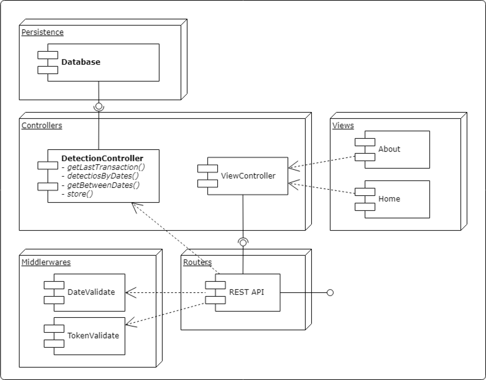
Basically, the web application implements a REST API, which is the input interface for data sent by the counter and for requests from internal modules, as well as for external systems. This approach contributes to the interoperability and integral functionality of the system as a whole [7].
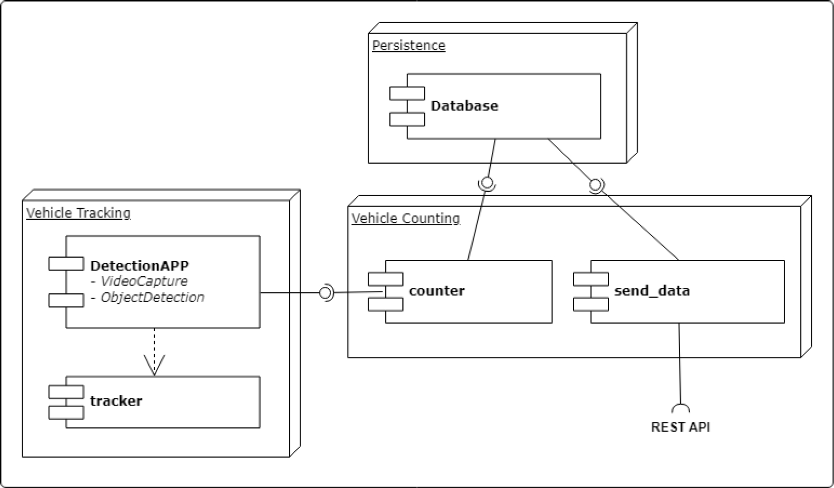
Fig. 4 presents the outcome of the vehicle counter design. The diagram shows the interaction of the components of the vehicle counting system, which will run on the Jetson Nano™ device. The system is divided into three main components: vehicle detection and tracking, vehicle counting, and sending data to the server. Data is sent to the server periodically (e.g., every 30 minutes), for which the local database records are consulted and the results are sent to the server through REST API requests.
An overview of the system design is provided in Fig. 5, which illustrates the entire system’s architecture, its physical and logical components, and the flow of the data through those components.
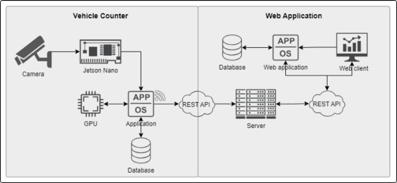
The illustration distinguishes the different parts that make up the entire system. On the left side are the vehicle counter components, which include the camera, the Jetson Nano™ minicomputer, the application that uses the selected ML model for detection, tracking, and counting, as well as data transmission and its respective database. Similarly, on the right side of the illustration are the components corresponding to the web application.
3.3 Prototype building
Regarding the prototype development, two results are presented. On the one hand, the results of the software development process and, on the other hand, the design and printing of the prototype of the housing for the electronic components for the vehicle counter.
The result of the development process, already described above, includes two main components: the software for the vehicle counter and the web application. The repositories with the source code can be found at the following links: for the vehicle counter at https://github.com/FACITEC-INV/jetson-yolov7, and for the web application at https://github.com/FACITEC-INV/vcounter_vista.
Figure 6 presents the prototype’s 3D design. One can see that it has several components, including the camera housing. The camera housing measures 280 millimeters in length, 110 millimeters in height, and 110 millimeters in width.
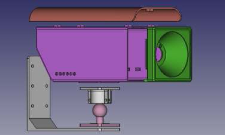
Once assembled, the design proved to be adequate to contain all the electronic components necessary for the operation of the vehicle counter system.
3.4 Testing and deployment
With the printed housing structure, the prototype was assembled and installed. Fig. 7, shows an image of the vehicle counting equipment installed at the entrance of ”MP Sales S.A.”.
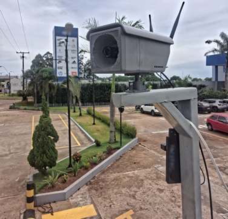
During the tests, the correct operation of the counting of vehicles circulating on the road was verified. In the same way, the collected data is sent periodically to the server. This data collected on the server is publicly available for access through a web application.
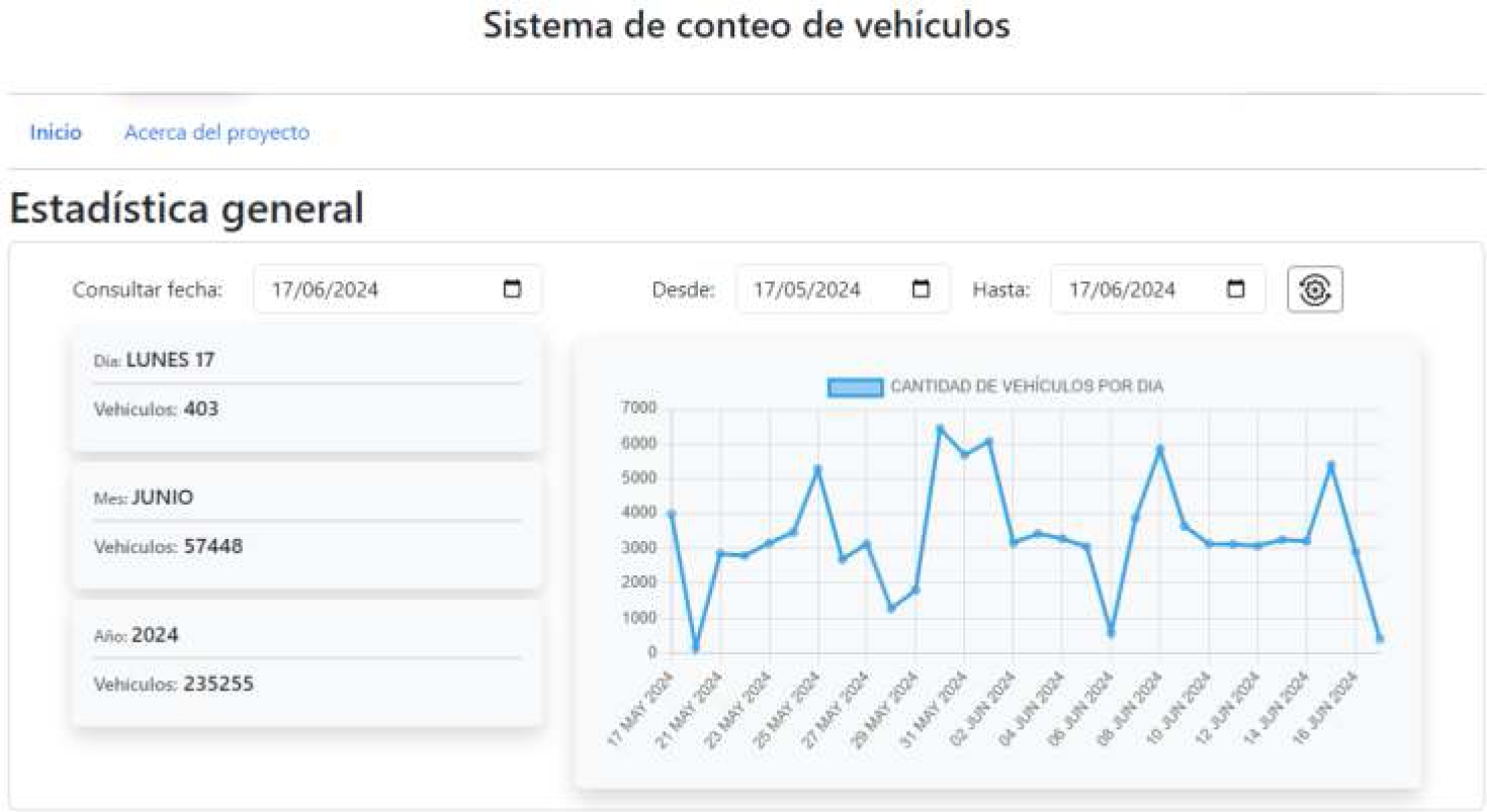
Finally, Fig. 8 shows the interface of the web application for querying the collected counting data. As can be seen in the illustration, this data can be viewed through a web application that is available for consultation, both in total value format and in a graph that allows visualizing the variations in vehicle flow over time. The application is available at the link https://appmapy.facitec.edu.py/.
4 Conclusions
In this work, a vehicle counting system based on machine learning models has been developed to analyze tourist flow in the city of Saltos del Guairá. Therefore, the system has the potential to address the needs of the local company ”MP Sales S.A.”. The system consists of two main components: a vehicle counter implemented on a Jetson Nano™, and a web application for visualizing and analyzing the collected data.
Based on the results obtained in the vehicle counting tests, the YoloV7-tiny model with SORT tracking algorithm was selected for the implementation of the counting system. This technology was the one that showed the best results among the evaluated models. It should be noted that more tests are required, since the TrafficCamNet model also showed good results when used with the SORT algorithm.
The choice of the ML model depends on the needs of the project. In other contexts with different needs, other, more suitable models can be considered. One way to increase the precision of models is by either retraining on them or developing specialized ones tailored for Edge Computing settings. Such spikes can include TensorRT among many others.
The model to be selected depends on the needs of the project and, therefore, in other case studies, other more suitable models can be considered. In order to improve the accuracy of the models, it is possible to retrain the models or train their own models, considering optimization for this type of Edge Computing environment, using tools such as TensorRT for this purpose.
The analysis and design of the system components, as well as the housing for the electronic components of the vehicle counter, enabled the development of two software applications that work together through an API. This API facilitates the interoperability and scalability of the system, allowing for the incorporation of new counting points for the collection of spatially distributed data.
It can be considered that the developed system offers a viable and affordable solution to the city of Saltos del Guairá, facilitating the monitoring of the flow of tourists entering the city. In addition, it serves as a basis for future improvements and adaptations of the system in other localities.
It is relevant to mention that the system developed could also serve the needs of the company “MP Sales S.A.”. This is because it also allows for the detection of vehicles entering the premises.

