


 nueva página del texto (beta)
 Inglés (pdf)
 Artículo en XML
 Referencias del artículo
 Enviar artículo por email
 Citado por SciELO
  Similares en
SciELO
Similares en
SciELO 
 Permalink
1. Introduction
Disasters caused by extreme precipitation events are increasing globally both in magnitude and frequency, more than any other climatic phenomenon (IPCC, 2021). According to the World Economic Forum (2022), extreme weather events have been declared the cause of significant damage to properties, infrastructure, and the environment, as well as the loss of human life. In mountain areas, geomorphological processes triggered by precipitation are one of the most common hazards faced by local populations (Guzzetti et al., 2007; Šilhán and Stoffel, 2015; Lambiel, et al., 2020). These events develop on spatio-temporal scales that cannot generally be monitored by conventional systems for monitoring rainfall, runoff and sediment discharge (Creutin and Borga, 2003).
Extreme precipitation events are defined as those caused by meteorological phenomena (tropical waves, squall lines, fronts, and tropical and extratropical cyclones, among others). The analysis of meteorological phenomena and extreme climatic events is complex because of the diversity of factors that intervene, such as local and regional atmospheric circulation, distance from the sea, elevation, landforms, and geomorphological processes. The definition of an extreme precipitation event is subjective because definitions vary by region. The maximum rainfall, however, does not necessarily cause floods or gravitational mass movement. These movements only occur if there are conditioning factors (geological, geomorphological, edaphic and land-cover) that, when combined with the characteristics of extraordinary precipitation events (magnitude, intensity, duration and antecedent precipitation), favor their occurrence (Chleborad, 2000; García-Pertierra, 2020).
Floods are recognized as one of the most important agents in landscape modeling since they shape mountain valleys, erode stream banks, beds, and adjacent slopes, deposit of transported material and adjust of vertically oscillating bedforms, such as pools, and riffles (Thompson and Croke, 2013; Hajdukiewicz et al., 2016; Šilhán et al.,, 2016). Mass movements also substantially change the morphology of valley slopes, promoting the modification of hydrological processes, such as infiltration and runoff, and eventually damming the water flows (Solís-Castillo et al., 2019). In general, a precipitation threshold is defined as the minimum accumulated precipitation in which a mass movement can be triggered, and these have been defined as global, regional, or local thresholds (Crosta and Frattini, 2001; Guzzetti et al., 2007).
The existence of reliable historical hydrometeorological data and observations allows the reconstruction of past event chronologies (Seneviratne et al., 2012; Böhner and Bechtel, 2017; Zeng et al.,, 2020). Current knowledge of the understanding of the dynamics and occurrences of hazardous events, based on meteorological, hydrological, and geomorphological data, provides general information. However, temporality and sparseness of the data increase uncertainty for management and planning decisions (Borga et al., 2014). Hazard assessment requires information on the intensity (or magnitude) and the probability of occurrence (or frequency) of an event, as well as the diagnosis of the geo-hydromechanical processes that cause it, its space-time evaluation, and its consequential damage (UNDRR, 2019).
The three most important limitations in carrying out hydrometeorological studies are: a ) the scarcity of data sampling points or measurement stations, b) the discontinuities in the measured data, and c) the quality of the temporal records (Scheel et al., 2011; Khalighi-Sigaroodi et al., 2019). These problems are observed in mountain areas, where measuring hydrological and precipitation parameters using traditional methods is difficult because of the topography, isolation, and great climatic variability. Despite these limitations, there are multiple techniques that can be used to characterize and understand the behavior of floods and landslides; among these is dendrochronology.
Dendrochronology is a technique that uses annual tree rings to date and infer past environmental conditions (Fritts, 1976; Speer, 2010), and it use in geomorphology is called dendrogeomorphology (Stoffel et al., 2010, 2013b; Mendoza et al., 2023). Tree-ring series represent one of the most valuable and precise natural archives for the reconstruction of natural and anthropogenic events, such as the reconstruction of the magnitude of floods and mass movements (Stoffel and Bollschweiler, 2009, 2010; Tichavský et al., 2017; Šilhán et al., 2018).
Although there are several review articles on the application of dendrochronology for evaluating these hazards, most have focused on applying this technique to analyze the dynamics and dating of geomorphological processes associated with these hazardous events (Tumajer and Treml, 2013; Ballesteros-Cánovas, et al., 2015a; Bodoque et al., 2015; Šilhán, 2020, 2021b; Bovi et al., 2022; Tichavský, 2023). No one has analyzed the literature regarding floods and mass movement events in relation to detailed knowledge of the physical-geographical characteristics of the areas where extreme precipitation events happen.
Therefore, the objective of this research is to analyze how dendrochronological techniques have been applied to predict hazards associated with rainfall events (floods and mass movements) in mountainous areas. The review demonstrates the potential that dendrochronological techniques possess for identifying needs and opportunities for future research on hydrogeomorphic processes, hazards, and associated disaster management.
2. Hydrogeomorphological hazards associated with extraordinary rainfall events in mountain areas
Mountain rivers are characterized by high stream gradients and coarse (gravel to boulder) stream-beds, and they generally run in confined valleys with rough banks and limited floodplains (Wohl and Merritt, 2008). Floods and mass movements depend on the following: a) the degree of inclination and orientation of the slope, b) soil type, c) land cover and land use, c) geological structure and rock composition, and d) the hydrogeological condition. In case of precipitation, historical behavior, intensity-duration, and previous accumulation must be taken into account (Finlay et al., 1997; Hong et al., 2006; Melchiorre and Frattini, 2012; Chen et al., 2019).
2.1. FLOODS
Understanding the physical processes leading to flooding and the probability of occurrence is one of the most complex areas of basin hydrology. These processes are controlled by the following: a) the precipitation regime, b) snow melting, c) the state of the basin, and d) its morphometric characteristics, as well as the interaction among them (Merz and Blöschl, 2003; Ghoneim and Foody, 2013).
The reconstruction of past events allows the flood-prone areas to be identified (Garrote et al., 2018). Floods can be sudden, as the result of intense rains in a short period of time, or progressive, lasting for several days or weeks when the riverbed cannot sustain the volume of water produced (Merz and Blöschl, 2003). In addition to the geomorphological processes, the magnitude of floods can also be classified based on the area of the basin that the flood reaches (Benito and Hudson, 2010; Figure 1).
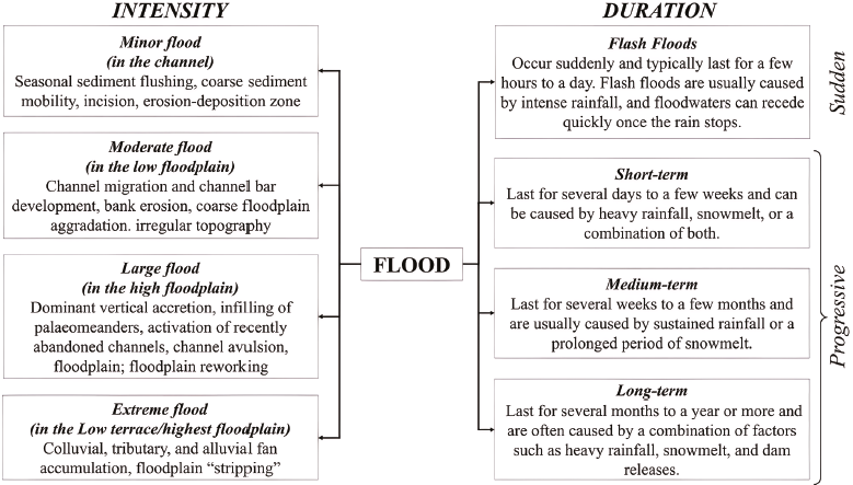
Source: Elaborated from Merz and Blöschl (2003) and Benito and Hudson (2010).
Figure 1 Classification of floods
2.2. MASS MOVEMENT
The mass movement refers to the mass transport of earth (consolidated and unconsolidated) and rock materials under the governing control of gravity (Günther, 2022). Gravitational mass movements are the main phenomena modeling the relief of mountain slopes and, simultaneously, are an important threat to peoples' lives and property (Malik et al., 2017).
The term landslide (defined as the movement of earth, debris and rock materials downslope under the direct influence of gravity (Cruden and Varnes, 1996) is commonly used synonymously with mass movement in the scientific literature. In recent years, however, a general agreement is that surficial and near-surface gravity-driven mass wasting processes, not necessarily attributed to sloping ground, should also be included in "mass movement," such as movements caused by near-surface ground subsidence or deep-seated gravitational slope deformations. In turn, gravity-driven movements of slope materials other than rock, debris, or soil may still be excluded from mass movements in a geomorphological sense (e.g., snow avalanches) (Günther, 2022).
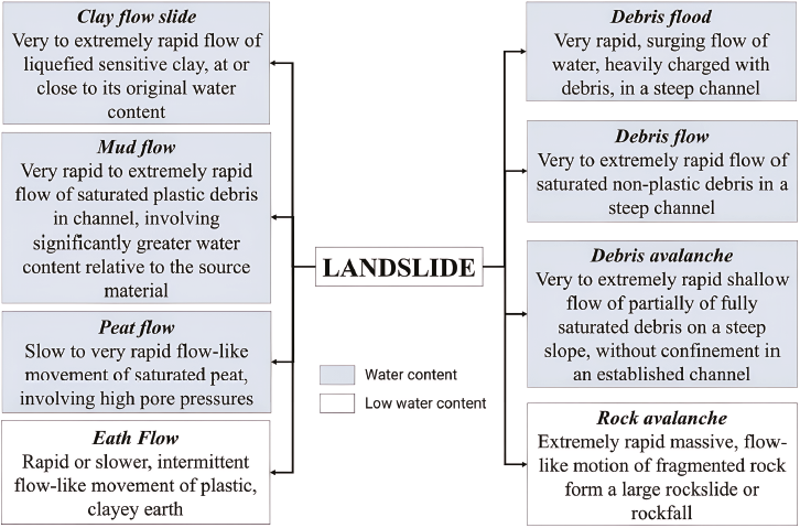
Landslides are natural geomorphic processes that modify the landscape and supply sediments to river channels; therefore, they are key in the dynamics of the Earth's surface (Ruiz-Villanueva et al., 2011; Sidle and Bogaard, 2016). According to Hungr et al., (2001), landslide phenomena can be usefully divided into the following classes: the flow type based on the material type, water content, presence of excess pore pressure or liquefaction at the source of the landslide, presence of a defined recurrent path (channel) and deposition area (fan), as well as velocity and peak discharge of the event. The classification based on the water content involved in the process is a relevant choice for this research, as it focuses specifically on hydrogeomorphological hazards triggered by rainfall (Figure 2).
Conversely, the term rockfall should be reserved for talus-forming independent rolling, fall, and bouncing of discrete rigid fragments, individually or in swarms (Hungr et al., 2001). Rockfalls are defined here as the free or bounding fall of rock debris down steep slopes varying in volume from individual small pebbles to catastrophic failures of several million cubic meters (Luckman, 2007). Triggering mechanisms of rockfalls include earthquakes, freeze-thaw cycles of interstitial water, and the thawing of permafrost or intense rainfall; rainfall can significantly influence rockfall by penetrating the rock mass and weakening the rock's mechanical properties (Stoffel et al., 2011).
There is no doubt that rockfall is a complex process dependent on many natural factors, including meteorological. This complexity makes it difficult to distinguish the relationship between precipitation series and meteorological elements; moreover, the uncertainties in microclimatic patterns at individual sites complicate the performance of effectiveness (Brázdil et al., 2012).
Lahars, which are fast-moving, destructive mudflows that occur in volcanic regions, can also significantly damage buildings, bridges, and other infrastructure, as well as bury entire communities under meters of mud and debris. Additionally, they can affect water quality by depositing sediment and other contaminants into streams and rivers. When volcanic materials become saturated with water, they can lose their stability and begin to flow downslope under the influence of gravity. These are typically composed of a mixture of volcanic ash, rocks, debris, and water, and these materials can travel at high speeds down valleys and slopes, often following river channels. They are typically triggered by volcanic activity, such as eruptions or the collapse of volcanic slopes, but they can also be caused by earthquakes, heavy rainfall, or other factors that destabilize the slopes of volcanoes (Vallance and Iverson, 2015).
2.3. ESTIMATION OF HAZARDS CAUSED BY EXTRAORDINARY RAINFALL EVENTS WITH DENDROCHRONOLOGY TECHNIQUES IN MOUNTAIN AREAS
Tree rings are a reliable tool for acquiring data about past events and understanding geomorphic processes for the assessment of natural hazards (Stoffel and Bollschweiler, 2008). The combination of dendrochronology with geomorphology (dendrogeomorphology) is based on the ability of trees affected by geomorphic processes to record external disturbances in ring-width sequences (Shroder, 1978). The use of dendrochronological techniques is helpful in areas with scarce instrumental data because it is an accurate method for creating a chronology of mass movement/flood events in forested basins (Tichavský et al., 2017).
The technique has great potential in identifying and dating disturbances recorded in the tree rings affected by different hydrogeomorphological processes (Stoffel et al., 2010; Stoffel and Corona, 2014). Consequently, dendrochronology is a useful tool for analyzing the frequency and magnitude of these events on an intra-annual scale in forested areas (Šilhán and Stoffel, 2015).
Dendrogeomorphological studies on hydrogeomorphological processes are generally based on the process-event-response model, defined by (Shroder, 1978). The model considers that affected trees may produce one or more responses in their morphology, such as reaction wood, growth suppression, growth release, growth termination, budding, succession, or various structural and morphological changes in the internal and external nature of the wood (Shroder, 1978; Díez-Herrero et al., 2013; Ballesteros-Cánovas et al., 2015b; Figure 3).
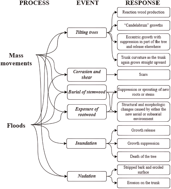
Source: Elaborated from Shroder (1978, 1980) and Ballesteros-Cánovas (2015b)
Figure 3 Process-event-response caused by landslides and floods on a tree-covered slope.
Following Butler et al. (1987), two general approaches can be discerned in the literature for tree-ring chronologies of catastrophic processes. One approach establishes the minimum age of tree growth so that the oldest dated trees provide a minimum estimate of the time since the occurrence of the event. A second approach examines the ring patterns of surviving trees for evidence of tissue growth over scarring and abrading caused by the geomorphic impact of floods, ice jams, landslides, or snow avalanches.
3. Materials and methods
Our search for publications focusing on the use of dendrochronological techniques to address hazards associated with extraordinary rainfall events in mountain areas before 2022 was performed in the Scopus and Web of Science databases. The criteria were based on the articles and book chapters published regarding the most recent advances and research strategies in the subject. Theoretical and methodological articles, as well as literature review articles, were not considered because only works where dendrochronology was applied were taken into account.
The search was performed using the following keywords: dendrochronology OR dendrogeomorphology AND hazard AND mountain AND rainfall OR precipitation.
The papers resulting from the searches were limited to case studies and filtered by selecting only the articles that fit the objectives of this research. The articles yielded various pieces of information, including the following: the papers' data (title, authors, year, journal, location of the database); types and number of hazards studied; the country and continent where the study area is located; the number of events identified in the timeline; and the study area's characteristics, such as its size, climate, elevation and rainfall thresholds considered for triggering hazardous processes. Additionally, the details of dendrochronological sampling were noted, including the number of trees used, the number and type of species, the number of samples (in wedges, slices, or cores), and the maximum and average age of the trees (Figure 4).
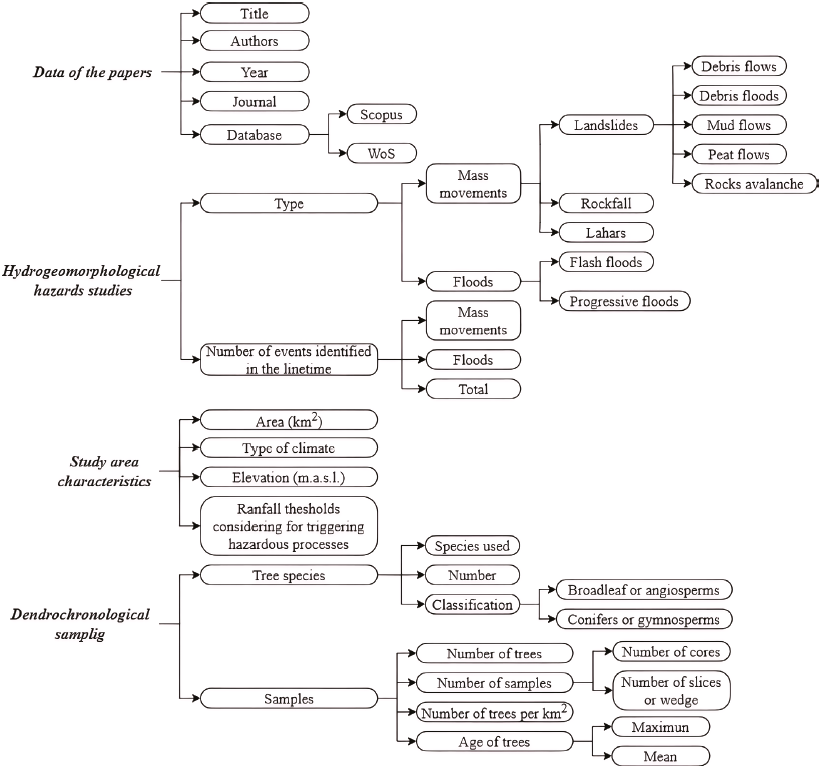
Figure 4 General structure of the database created for the analysis of the articles resulting from the search.
To determine the climate in each study area, a Köppen climate spatial distribution map was used for the period between 1901 and 2010 (Chen and Chen, 2013) and available at http://hanschen.org/koppen (Chen and Chen, 2023). The Köppen climate classification was developed based on the empirical relationship between climate and vegetation. This type of climate classification scheme provides an efficient way to describe climatic conditions defined by multiple variables and their seasonality with a single metric (Chen and Chen, 2013).
Trends in the use of dendrochronological techniques were analyzed using the Mann-Kendall statistical test, which is a non-parametric test that evaluates whether an time data set exhibits an increasing or decreasing trend, within a predetermined level of statistical significance. In this case, a p-value (α) of 0.05 is used (Hirsch et al., 1993; Mendoza et al., 2006).
4. Results
A total of 174 publications were retrieved from the search, with 24 (14%) found only in Scopus, 43 (23%) found only in WoS, and 110 (63%) works found in both databases.
Of the reviewed publications, 130 (74.7%) were exclusively related to the study of mass movement hazards, while 40 (23%) focused on floods. Four (2.3%) covered both topics. A total of 92% of the publications studied only one hazardous process, 6% studied two processes, and only 2% studied three processes.
It is important to note that many authors use the terms mass movement and landslide interchangeably. For example, 69% of the articles reviewed were related to landslides, although not all authors used this term in accordance with the classifications considered in this study. The general term, landslide was used in 55.8% of the papers related to landslides, while 38.3% were related to debris flow, 3.3% to debris floods, while peat flows, rock avalanches, and mud flows each represented 0.8%. The articles related to rockfalls, and lahars accounted for 14.9% and 4.5%, respectively. In relation to floods, 62.2% of the articles reviewed focused on progressive floods, while 37.8% studied flash floods (Figure 5).
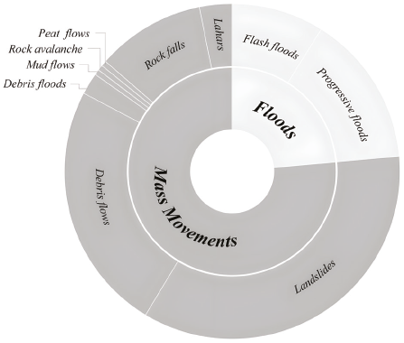
Figure 5 Revised publications related to the study of mass movements and floods hazards in mountainous areas through dendrochronology.
The earliest publication found that applied dendrochronology in the study of hazards related to extraordinary precipitation in mountain areas dates to 1986 and was related to mass movements. A significant upward trend (z = 5.9003) in the number of related publications, however, was noted starting in 2005, with a peak in 2017 and a secondary peak in 2021. Publications related only to mass movements had an increasing trend (z = 5.572). Studies related to flooding were found from 2009 onwards, with a significant upward trend (z = 5.1426) since that time, peaking in 2020 (Figure 6).
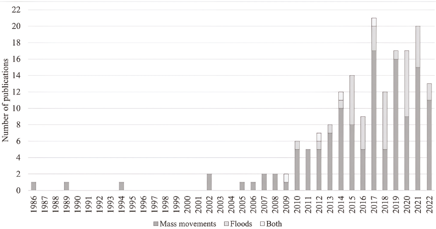
Figure 6 Number of publications per year related to the study of mass movements and flood hazards in mountain areas through the application of dendrochronology.
With respect to the number of events identified in chronologies through dendrochronological analysis, 11.5% of the works reviewed did not provide this information. The largest proportion of papers (25.8%) identified more than 20 events in their chronologies. Additionally, 20.2% identified between 11 and 20 events, 19.1% identified between 6 and 10 events, and 15.2% identified between 2 and 5 events. Only a small proportion of papers (8.4%) focused on the analysis of a single event (Figure 7).
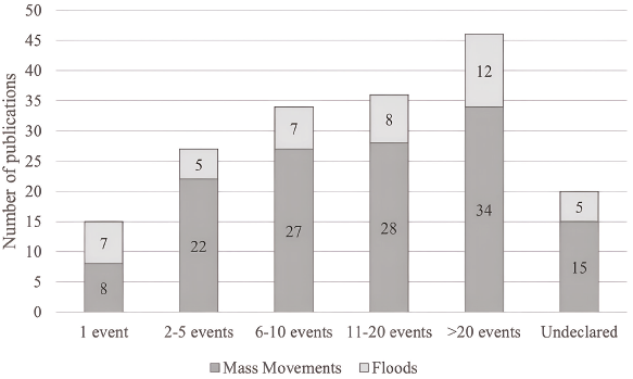
Figure 7 Number of events per publication related to the study of mass movements and flood hazards in mountain areas through the application of dendrochronology.
The analysis of the reviewed publications revealed that 48% of the works used a single species for their dendrochronological analysis. Most of the publications (52%), however, reported the use of more than one species in their research. Specifically, 19% of the works used two species, 13% used three species.
3 species, 9% used between 4 and 8 species, and 8% used between 9 and 12 species (Figure 8a). Regarding the species used in the studies, most (78%) used coniferous species in most of their sampling, while 16% used broadleaf species. Information regarding the species used was not provided in 6% of the works (Figure 8b).
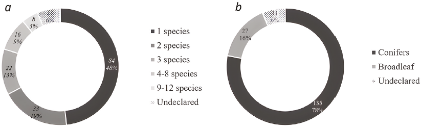
Figure 8 a) Number of species used and b) tree species classification of the publication related to the study of mass movements and flood hazards in mountain areas through the application of dendrochronology.
Observing the total number of works reviewed, the most frequently collected species were Picea abies (44.8%), Fagus sylvatica (12.6%) and Abies alba (9.8%). The most collected genera, though, were Picea (50%), Pinus (37.4%) and Acer (19.5%). The most used tree species in the studies of mass movements were Picea abies (35.6%), Fagus sylvatica (9.8%) and Larix decidua (9.2%) (Figure 9a), while, in studies on flood hazards, the most collected species were Picea abies (%), Pinus sylvestris (15.8%) and Alnus glutinosa (13.2%) (Figure 9b). In the flood hazard publications, 77 species were analyzed, while in the landslide publications, 41 species were involved.
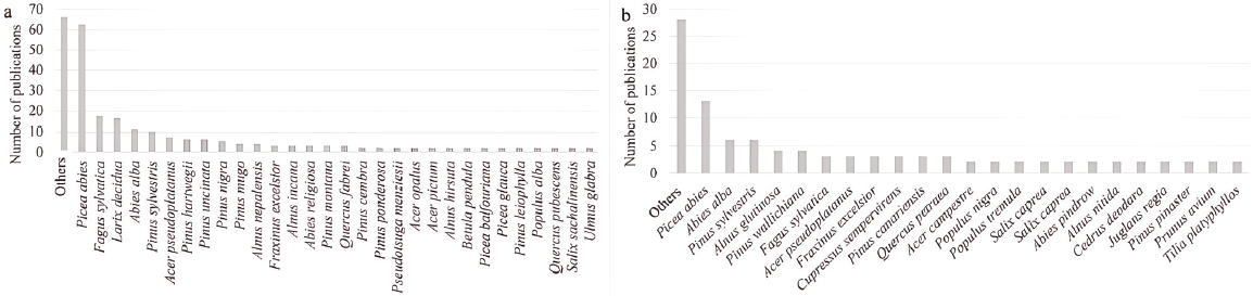
Figure 9 Tree species most used in studies associated with hazards from a) mass movements and b) floods caused by extraordinary rainfall events in mountain areas.
In most of the research, sampling was performed with a Pressler increment borer, and between 2 and 4 samples were collected per affected tree. In the cases where cross sections were collected, they were mostly taken from dead trees and roots exposed by mass movements and/or erosion. On average, 63 trees per km2 were sampled, with a maximum of 645 (Šilhán et al., 2022) and a minimum of 1 tree per km2. Nevertheless, it is important to note that 40% of the publications did not report the size of the study area, and 9% did not specify the number of trees used in their analysis. On average, the age of the trees used was 118 years (standard deviation: 55.7 years), with a maximum of 1,100 years (Speer et al., 2019), although 43.1% of the papers did not specify the trees' average age, and 37.9% did not declare the maximum age.
In the search, 25 countries were identified in which research had been conducted by applying only dendrochronological techniques for studying hydrometeorological hazards, mainly in snow and mild temperate zones. Most studies were developed in the Dfb climate (Snow, fully humid with warm summer) of European countries, from which most of the research originated (Figure 10).
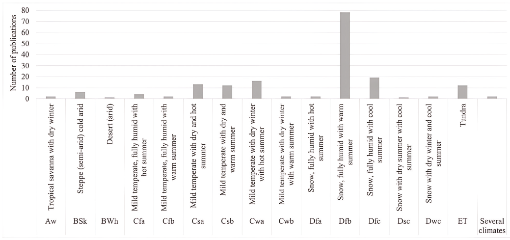
Figure 10 Type of climate according to Köppen's classification in which the studies were performed. "Several climates" refers to studies that were conducted in multiple regions or areas with distinct climatic conditions.
The reviewed articles' topics included the following: a) the determination of rainfall thresholds for the occurrence of hazardous events, b) the analysis and reconstruction of hydrogeomorphological processes, and c) the influence of meteorological, climatological conditions, as well as climate change phenomena on the occurrence of hazardous events in mountain areas.
In 78.7% of the reviewed studies, the precipitation threshold required to trigger hazardous events after or during hydrometeorological phenomena was not determined. These works usually only described the rainfall regime and the maximum rainfall recorded historically or during the occurrence of a hydrometeorological event that caused one of the studied hazards. Moreover, 15% of the studies reviewed in this research defined a daily rainfall threshold based on their local climate conditions; 2.3% of the studies established this threshold based on rainfall intensity or accumulation within a 1-hour period. Furthermore, 3.4% considered additional variables such as accumulated rainfall over 3 and 5 days, seasonal rainfall patterns, and accumulated rainfall from previous months.
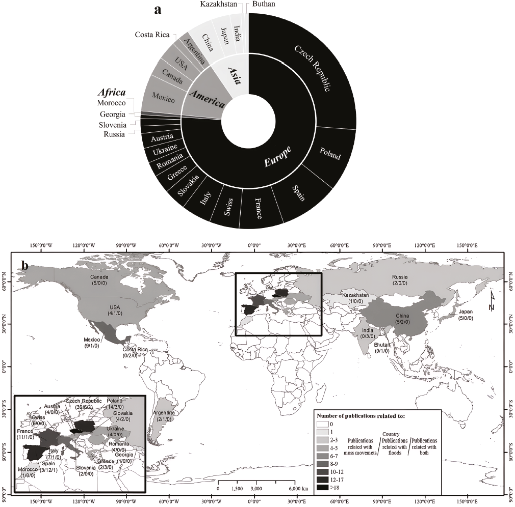
Because of the nature of the phenomena being analyzed, most publications have been developed at a local scale. Only 2.7% of the studies focused on regional analyses. It should be noted, however, that this percentage includes several studies that integrated local-level data from various areas into a regional analysis. First, the largest number of studies were concentrated in Europe (77%) and were performed mainly in the Czech Republic (47), Poland (17), Spain (16), France (12), Switzerland (8) and Italy (8). Second, studies conducted in the Americas accounted for 12.6% of the total, with the distribution as follows: Mexico (10), Canada (5), the United States (5), Argentina (3), and Costa Rica (2). Third, studies conducted in Asia accounted for 9.8% of the total, with the distribution as follows: China (7), Japan (5), India (3), Bhutan (1), and Kazakhstan (1). In Africa, only 1 paper was found in Morocco (Figure 11).
5. Discussion
Dendrochronological techniques have been applied since the early second half of the 20th century (Sigafoos, 1964), but their application in the study of hazardous events in mountain areas mainly began in the 1980s. This led to an increase in the understanding of the links between geomorphic and hydrological processes in these environments (Sidle and Onda, 2004).
In the past decade, there has been a notable increase in the number of studies describing hazards in mountain areas. The application of dendrochronological techniques in dendrogeomorphological studies is still limited (Goerl et al., 2012), especially when compared with other widely used techniques in complex environments like mountain areas where instrumental data is scarce. Moazami et al. (2016), for example, used hydrological modeling, including spatial interpolation, statistical regression, and precipitation estimation algorithms based on assimilated data from satellite imagery. Nevertheless, some of these methods may be highly uncertain.
5.1. ADVANTAGES AND DISADVANTAGES OF DENDROCHRONOLOGICAL TECHNIQUES IN HYDROGEOMORPHOLOGICAL HAZARD
Dendrochronology has provided extensive information on an event if there are witness trees, and its application can identify the geomorphological and hydrological dynamics that trigger the occurrence of hazardous events. Furthermore, it allows for better estimating the characteristics of the spatial extension and magnitude of the event.
The application of dendrochronological techniques is useful in relating botanical, geomorphological, and sedimentological evidence to past hazardous hydrometeorological and hydrogeomorphological events in mountainous areas. The damaged trees can provide long-term information about the frequency and magnitude of hazardous events, including mass movements and floods, which is essential for understanding the behavior of natural systems and making accurate predictions of future events. Tree rings also allow for the dating and/or a chronology of hazardous events, which can be difficult to achieve through other means. They also provide evidence of past environmental changes, such as climate variability and land-use changes, which can help improve our understanding of how these factors influence the occurrence of current and future hazardous events.
Dendrochronological techniques, however, can only be applied to trees and shrubs, which means that they are limited to areas where trees are present and are not useful for evaluating events that have occurred in areas without woody plants. Additionally, they can only be applied when trees are damaged or anatomically respond to a geomorphological event; in cases of high magnitude events where all trees are eliminated, dendrochronological techniques are not useful for evaluating such events (Ballesteros-Cánovas, et al., 2015b). In addition, the interpretation in science, specifically of dendrogeomorphological data, can be subjective and requires significant expertise, which can limit its use for some researchers or practitioners. Finally, the technique can also be time-consuming and expensive, especially in remote or difficult-to-access areas.
5.2. IDENTIFIED GAPS
Most of the tree species collected in the analyzed papers were species native to temperate and cold climates. Consequently, there is a lack of dendrochronological knowledge in intertropical mountain areas. Nevertheless, a few dendrogeomorphological studies have been performed in México and Costa Rica in recent years (Stoffel et al. 2011, Franco-Ramos et al., 2013, 2016; Quesada-Román et al., 2020; Figueroa-García et al., 2021).
Dendrochronological problems dating tropical tree species are responsible for a large gap in event reconstruction (Villalba et al., 1985). Despite encouraging progress in their use, it is still believed that most of these species do not produce anatomically distinctive annual growth rings that can be used for the development of extensive chronologies. This is why identifying those few species that are of great use for this field in the tropics remains a great challenge for tropical dendrochronology (Stahle, 1999). Until recently, tropical trees have been described as plants of rapid and continuous growth throughout their useful life, so the presence of annual growth rings in their wood was not recognized. Some authors, however, have managed to explain the periodicity in the formation of wood by linking physiology and anatomy (Détienne, 1989). Despite the great variability of tree rings in tropical regions, their annual nature has been proven for many species, opening up the possibility of applying the analytical studies of tree rings more widely in the tropics (Worbes, 2010; Roig et al., 2012; Acosta-Hernández et al., 2017).
These analyses are not simple, but they are a necessary challenge for understanding the dendrochronological potential of intertropical species in order to estimate the magnitude, frequency, and spatial distribution of hazardous events in mountain areas at latitudes less than 23° north and south because tropical and subtropical forests encompass nearly half of the tree density at the global scale (Crowther et al., 2015). Dendrochronology in the tropics is more complex than in temperate regions, because of the larger number of species, variety of habitats, variable cambial activity, and the complex phenology over the year in the absence of well-defined seasons (Silva et al., 2019). Some of the potential species to be analyzed in those geographic areas are Cedrela odorata, Carapa guianensi, Toona ciliata, Erisma calcaratum, and Abies guatemalensis, among others.
A common theme is the characterization of factors that trigger hazardous events and their association with climate variability and change, which are critical components in the analysis of threats. Changes in precipitation patterns over time and space significantly affect the hydrogeomorphological dynamics of sites (Lopez Saez et al., 2013; Stoffel et al., 2014). A more comprehensive understanding of the dynamics of hazardous events is essential for developing mitigation and management strategies for these risks (Benito and Díez-Herrero, 2015; van den Heuvel et al., 2016; Camarero and Ortega-Martínez, 2021).
Having detailed knowledge of the physical-geographical characteristics of the areas where extraordinary precipitation events occur. The maximum intensity of rain per hour, the duration of the storm, the accumulated precipitation and the precipitation preceding the event, as well as the characteristics of extraordinary precipitation events, play important roles in identifying and characterizing rainfall thresholds, after which dangerous events associated with them may occur (Ruiz-Villanueva et al., 2011; Borga et al., 2014). Only 21.3% of the reviewed publications, however, conducted this type of analysis. It is important to highlight that precipitation thresholds should not be assumed by region or by areas with similar characteristics to determine the occurrence of hazards. Each area has its own meteorological and climatological characteristics that influence the water regime, the modeling of the overland flow, and the calculation of return periods of the associated hazardous processes.
Forecasting the occurrence of landslides triggered by rainfall requires identifying the thresholds of the amount of rainfall, soil moisture, or hydrological conditions that cause them (Guzzetti et al., 2007; Stoffel et al., 2013a; Singh and Kumar, 2021). Precipitation thresholds allow calculating the probability of landslide occurrence, and these thresholds can be estimated on a physical basis (based on processes) or empirically (based on historical data or statistics) (Guzzetti et al., 2008).
Understanding both the geological and geomorphic characteristics, as well as the rainfall characterizing a given area, contributes substantially to the spatiotemporal evaluation of landslides and can minimize their effects (Sajinkumar et al., 2020). The rock types and its structure, landforms (specifically the slopes' tilt), and geotechnical properties vary less over time, while precipitation shows greater temporal variation (Gariano and Guzzetti, 2016). Some of these properties are modulated by rain; therefore, an understanding of precipitation patterns also provides key information about an impending landslide, which can help design ways to mitigate its effects (Šilhán, 2021a).
The lack of consensus within the scientific community regarding the terminology related to the type of process further contributes to the degree of confusion with these terms (Hungr et al., 2001). It is crucial for researchers to define the terms they use clearly in their investigations, especially when dealing with technical and scientific concepts. Inconsistent or ambiguous use of terminology can also create difficulties in comparing and synthesizing findings across different studies.
It is important to note that details of dendrochronological sampling are crucial; yet sometimes this information is partially or entirely omitted. Data reporting is an essential aspect of dendrochronological studies as it allows for transparency and the reproducibility of the results. It also ensures that the methods used are standardized and that the collected data are accurate and reliable. Proper data reporting, including the number and species of trees sampled, the location and size of the study area, as well as the age and number of events identified in the chronologies, is necessary for creating robust and accurate growth-ring chronologies. Additionally, contextual information, such as site characteristics, sample collection procedures, and climatic conditions during the growth period, can aid in the results' interpretation. Nevertheless, not all the publications included mentioned information.
The number of sampled trees can affect the total amount of hazardous events identified. If too few trees are sampled, it is possible that some hazardous events that were registered in unsampled trees may be missing. Therefore, a broader and more representative sample can help to identify a larger number of hazardous events, avoiding the noise produced by limited sampling. Additionally, the age of the trees can also be important. Hazardous events can leave marks on tree-growth rings that may persist for several decades or even centuries; sampling older trees can help identify hazardous events that occurred in the more distant past and cannot be identified in younger trees (Stoffel, et al., 2013b).
In general, the number of hazardous events identified in a dendrochronological study include several key factors, such as the number and age of sampled trees, the accuracy and temporal resolution of the growth-ring record, and the intensity and frequency of hazardous events in the studied region. Therefore, it is important to consider these factors when designing and conducting a dendrochronological study and interpreting its results. At an individual site, the choice of sampling design and selection of the trees to be sampled will depend on the purpose of the investigation and the processes or hazards being sampled (Stoffel et al., 2010), as well as the proper identification of damaged trees.
6. Conclusions
We carried out a broad and exhaustive review of the state of the art in the Scopus and Web of Science databases, performed through a rigorous selection method. The review of the state of the art allows generating a baseline of useful knowledge and identifying the approaches applied to the investigations, which are fundamental in increasing the clear understanding of hazardous events. It also corroborates the growing interest of researchers in this field. The integration of dendrochronological techniques in the study of hydrometeorological events has been useful in identifying the characteristics of the dynamics and influence of hydrological processes, as well as the reconstruction and evaluation of the magnitude of hazardous events mainly in European and North American mountain areas. This has generated an increase in the understanding of the processes and, therefore, the generate more efficient management and prevention recommendations.
Extraordinary rainfall events are one of the main triggers of floods and mass movements in mountain areas where records and measurements are scarce. Dendrochronological techniques have been useful in identifying areas with potential occurrence of disasters associated with these hazards. The developed studies have generated solid results in areas where direct measurements of meteorological and hydrological variables do not exist or are scarce. Knowing and understanding the precipitation thresholds from which hazards can also contribute to land-use planning and disaster risk reduction. Nevertheless, few studies have focused on identifying local rainfall thresholds.
The reviewed literature shows a marked trend towards the increase of dendrogeomorphological research regarding hazards associated with extraordinary rainfall events. However, there are few hazard estimation studies based on dendrochronology in intertropical zones, which have their own physical-geographic characteristics. Therefore, this situation constitutes a research line that must be developed to manage the hazard derived from hydrometeorological events and their associated risks in these poorly studied geographic areas.
Contributions of authors
(1) Conceptualization: DBR, MEM; (2) Analysis or data acquisition: DBR, MEM; (3) Methodologic/ technical development: DBR, MEM; (4) Writing of the original manuscript: DBR, MEM; (5) Writing of the corrected and edited manuscript: DBR, MEM, TCA, JVD; (6) Graphic design: DBR; (7) Interpretation: DBR, MEM, JVD; (8) Financing: MEM.
Financing
First author acknowledges CONACyT for her PhD grant. MEM would like to recognize financing through the UNAM projects PAPIIT IN11022 and IN108719, as well as through PASPA for his sabbatical grant of M.E.M.
Conflicts of interest
We declare that there is no conflict of interest.
Supplementary data
The data that support the findings of this study are available from the corresponding author, M.E.M., upon reasonable request.
Handling editor
Avto Gogichaishvili.

