


 nueva página del texto (beta)
 Inglés (pdf)
 Artículo en XML
 Referencias del artículo
 Enviar artículo por email
 Citado por SciELO
  Similares en
SciELO
Similares en
SciELO 
 Permalink
INTRODUCTION
Mineralogical studies constitute one of the main tools we possess to try to understand geological processes and the evolution of Mars (Ehlmann and Edwards, 2014). Different planetary missions have studied the geology of Mars by implementing an array of probing methods.
One of the first missions to map the Mars' surface were Viking 1 and 2 that returned images and conducted soil experiments (Soffen and Snyder, 1976) while Mars Global Surveyor mapped Mars and its topography (Albee et al., 2001). More recently, multispectral resolution has significantly increased, which allows the integration of detailed observations on geological formations. For example, the Observatoire pour la Minéralogie, l'Eau, les Glaces et l'Activité (OMEGA) imaging spectrometer on board Mars Express, has acquired data coverage of the Martian surface with spatial resolution varying between 300 m and 4.8 km (Bibring et al., 2004) and the Compact Reconnaissance Imaging Spectrometer for Mars (CRISM) with spectral range from ultraviolet (UV) to mid-wave infrared (MWIR), 383 nm to 3960 nm (Murchie et al., 2007). These studies allow the analysis of a wide range of geological processes and properties that are recorded in primary and secondary minerals.
Upcoming missions aim to deepen the research of the Martian geology to find evidence of life. One of these missions is ExoMars (Exobiology on Mars), a joint project of the European Space Agency (ESA) and the Russian Federal Space Agency (ROSCOSMOS) (Vago et al.,2017). ExoMars mission consists of an orbiter, the Trace Gas Orbiter (TGO), and the entry, descent, and landing demonstrator module (EDM). The main objective of TGO is to study in detail of atmospheric gases, including methane (CH4) and other minor components difficult to detect and observe on the surface, to hunt for signs of possible active processes (De Sanctis et al., 2022). ExoMars 2022 mission is composed of a lander and a rover. The rover includes a drill to collect samples and has a complex payload able to conduct detailed investigations of composition, search for organics, and recognize indicators of past or extant life (Vago et al. 2017). The Landing Site Selection Working Group recommended that Oxia Planum be considered as one of the two candidate landing sites for the launch opportunity in 2020, with a second to be selected from Aram Dorsum and Mawrth Vallis (Vago et al., 2015). About a year before the launch, ESA and Roscosmos will make the final decision of where to send the mission. It is probable that for political reasons, ROSCOSMOS will not participate in the program. ESA originally planned to cooperate with NASA on the ExoMars program but turned to Russia a decade ago when NASA pulled out of the program in 2028.
In this study, we collect and interpret the latest data of mineralogy of Oxia Planum and Mawrth Vallis. These regions are located in the northern hemisphere and belong to the martian quadrangle Oxia Palus, located at 0° to 45° west longitude and 0° to 30° north latitude (Figure 1). The region encompasses lands of the northern lowlands Chryse Planitia and Acidalia Planitia, and is delimited by the southern highlands, Xanthe Terra and Arabia Terra (Wyatt et al., 2003).
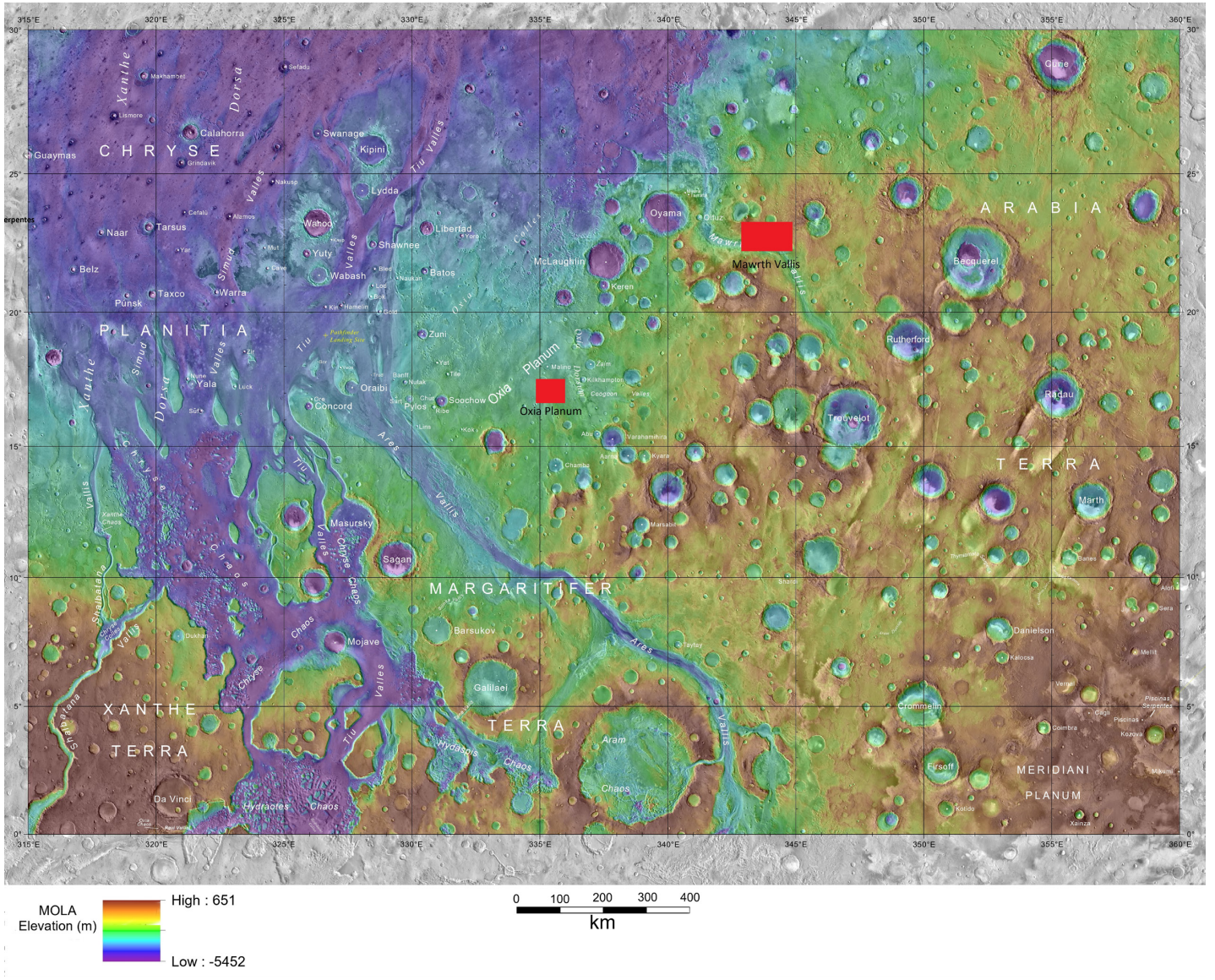
OXIA PLANUM AND MAWRTH VALLIS
Oxia Planum (17-20°N, 334-337°E) has a rich geological history and experienced diverse aqueous episodes, all dated to Noachian times, followed by late volcanic activity (Quantin-Nataf et al., 2021). The area is largely dominated by clays, and includes valley networks, Noachian channels, and what appears to be a delta (Mandon et al., 2021). An Amazonian lava flow covered the region, but wind through the Hesperian and the Amazonian exposed the surface that we see today (Quantin et al., 2014).
The zone exhibits remarkably uniform spectral features consistent with a type of Fe/Mg-rich phyllosilicates (Carter et al., 2016). Presence of Fe, Ca-rich carbonates is recognized by Brossier et al., (2022) with the absorption near 2.53 μm and the observation of a broad peak in the 3-4 μm range, supporting their co-occurrence with the clays in Oxia Planum and its catchment area. Using the final isochron iteration diagram for Martian craters 2004, which marks subdivisions of the eras according to the definition of Tanaka (1986), the age of Oxia Planum was estimated to correspond to the mid/late Noachian Period, between 3.5 billion years (Ga) and 4 Ga (Figure 2a), comparing these data with the table of Platz et al., (2013) for the Oxia Palus region (Loc-20), we observe that the age corresponds to the middle Noachian period (3.9 Ga).
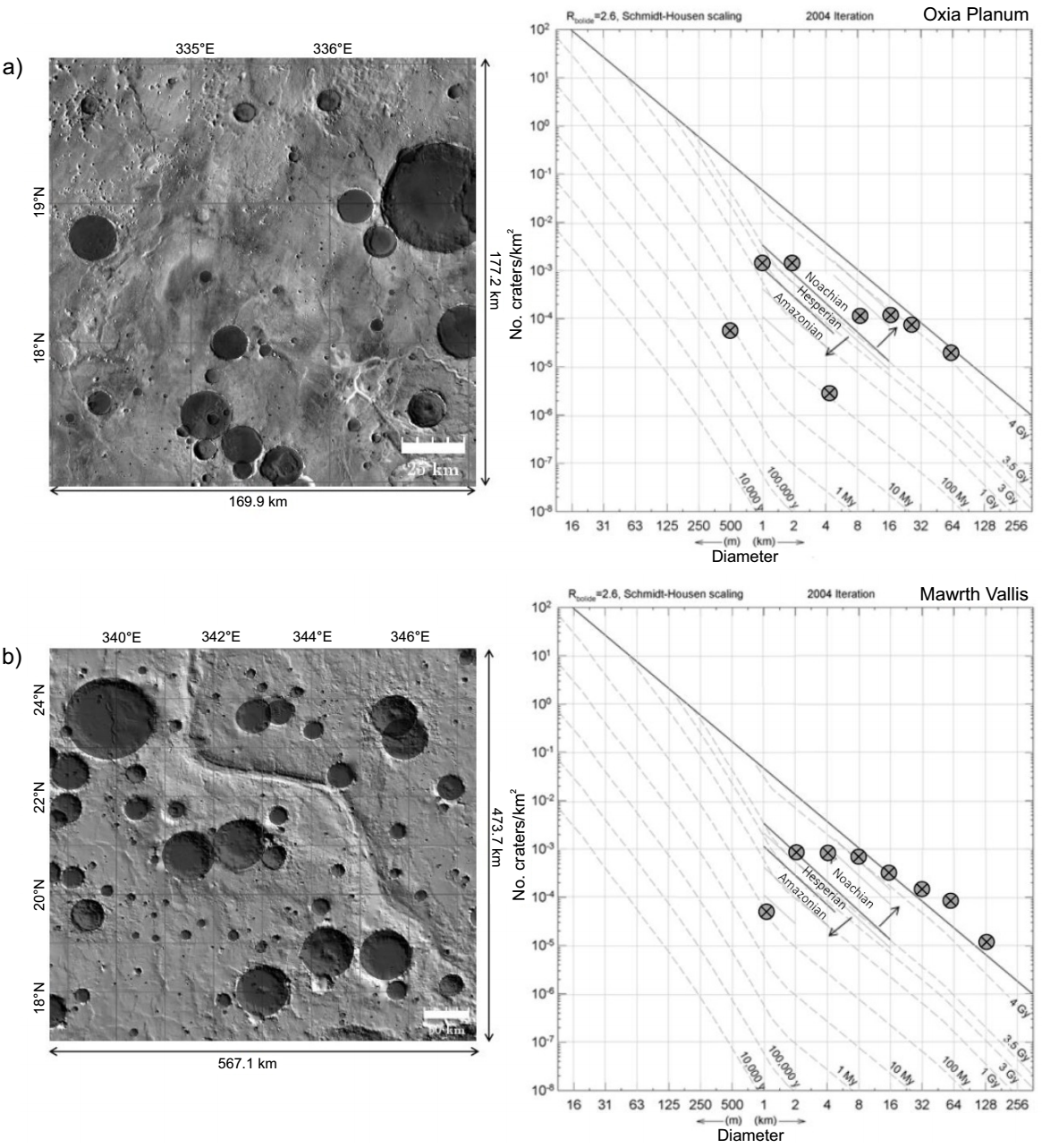
Figure 2 (a) Relative ages of Oxia Planum. The solid top-line marks the saturation balance. The shortest solid lines (1 km <D <16 km) mark divisions of the Amazonian, Hesperian, and Noachian epochs; lighter solid lines represent subdivisions of eras based on Tanaka's definitions (1986). (b) Relative ages of Mawrth Vallis. The solid top line indicates the saturation balance. The shortest solid lines (1 km <D <16 km) mark divisions of the Amazonian, Hesperian, and Noachian epochs. Lighter solid lines depict subdivisions of eras based on Tanaka’s definitions (1986).
The predominant fluvial landform in Mawrth Vallis is an outflow channel that crosscuts plateaus from the Noachian age, dated approximately to the Early Hesperian or Late Noachian epoch (Scott and Tanaka, 1986). By analyzing the morphology of the channel and a few streamlined islands, Loizeau et al., (2007) concluded that the water in the channel flowed from south to north. There are also small valleys at the bottom of the Oyama crater. Only few structural patterns are present in the region, the most important is a fault in the middle of the Oyama crater (Loizeau et al., 2007).
Around 14 mineral species, dominated by clays have been detected in Mawrth Vallis (e.g., Bishop et al., 2008, 2013, 2014; Bishop and Rampe 2016; Wray et al., 2010; Farrand et al., 2014; Michalski and Niles., 2011, McKeown et al., 2008, Lee and Park 2010, Viviano and Moersch 2013). According to the data used in the final isochron iteration diagram for Martian craters (2004), Mawrth Vallis age corresponds to the middle and late Noachian 3.5 Ga-4 Ga (Figure 2b).
We perform a comparative and interpretation study of the mineralogy of Oxia Planum and Mawrth Vallis. We highlight the impact that the presence of water could have had on the formation of the regions’ minerals and discuss the implications of the mineralogical associations for their formation, past environments, and presence of water in the region.
MATERIAL AND METHODS
Minerals detection maps
We use the Java Mission Planning and Analysis for Remote Sensing (JMARS) software, a Geospatial Information System to perform data analysis and mission planning; available at: www.jmars.asu.edu (Mars Space Flight Facility, Arizona State University, 2018), we collected maps and data from the Observatoire pour la Minéralogie, l'Eau, les Glaces et l'Activité (OMEGA) and the Thermal Emission Spectrometer (TES).
We use JMARS to acquire hydrated mineral abundance maps in the regions of Oxia Planum and Mawrth Vallis. In addition to hydrated minerals-the most important for this work, -other mineral classes have also been reported. These maps are available in this software and use data from the TES and the OMEGA instruments.
The OMEGA instrument has the capability to join these spatial and spectral scales through the direct measurement of high spectral (352 channels) and spatial (hundreds of meters to several kilometers) resolution of the uppermost fraction of the Martian surface. The wavelength range of OMEGA is 0.38-5.1 mm (Bibring et al., 2004).
The OMEGA instrument maps with the detection of hydrated minerals are used, marking one point per observation, regardless of the number of different hydrated mineral species found (Carter et al., 2013). In addition, the abundance maps for ferric oxide, olivine and pyroxene are included.
Meanwhile, the Thermal Emission Spectrometer carried on the Mars Global Surveyor (MGS) spacecraft consists of a Michelson interferometer along with solar albedo and broadband thermal channels. The spectrometer measures thermal emission between 200 and 1600 cm-1 with selectable nominal spectral resolutions of 5 and 10 cm-1. The individual pixels of the 2×3 detector array subtend 8.3 mrad (Conrath et al., 2000).
We use TES mineral maps abundance. Minerals were grouped by Bandfield (2002) into categories based on compositional and spectral similarity, with global concentration maps produced. We use amphibole, carbonates, potassium feldspar, hematite, plagioclase, quartz, sulphates, and olivine maps.
According to Bandfield, (2002), most surfaces are dominated by concentrations of 0-0.01 of each of quartz/amphibole mineral classes. Several separate, isolated regions have concentrations of each mineral group of 0.01-0.02; Regarding carbonates, most areas were dominated by concentrations of 0-5 % with the exception of equatorial low-albedo regions. These surfaces commonly indicate concentrations of 0.05-0.07. Feldspars were separated into two categories: potassium feldspars and plagioclases.
Hematite was identified above the detection limit in only two locations: Sinus Meridiani (0.10-0.20) and a single pixel within Aram Chaos (0.10-0.15). Most other locations show concentrations of 0-0.05, with the exception of northern hemisphere low-albedo regions that have some surfaces with concentrations of 0.05-0.10. Several areas show slightly elevated concentrations of olivine (?0.02-0.05), including areas coincident with high concentrations of hematite as well as an isolated region within north-eastern Syrtis Major and a low-albedo region immediately north of Argyre Basin. Several isolated pixels also display slightly higher concentrations in the far south (Bandfield, 2002).
High-Ca pyroxenes are identified in concentrations of 0.10-0.20 in equatorial low-albedo regions. High-latitude, low-albedo regions are characterized by concentrations of 0-0.10. Light regions have 0-0.05 high-Ca pyroxene concentrations. Only equatorial low-albedo regions have pyroxene concentrations above the detection limit. Low-calcium pyroxenes have primarily low concentrations (0-0.05) over the entire planet. Low-Ca pyroxenes remain under the detection limit (Bandfield, 2002).
The latest mineralogy data of Oxia Planum and Mawrth Vallis from the Compact Reconnaissance Imaging Spectrometer for Mars (CRISM) are integrated. CRISM is a hyperspectral imager launched on the MRO (Mars Reconnaissance Orbiter) spacecraft in August 2005. Spectral range spans the ultraviolet (UV) to the mid-wave infrared (MWIR), 383 nm to 3960 nm. The instrument utilizes a Ritchey-Chretien telescope with a 2.12° field-of-view (FOV) to focus light on the entrance slit of a dual spectrometer. Within the spectrometer, light is split by a dichroic into VNIR (visible-near-infrared, 383-1071 nm) and IR (infrared, 988-3960 nm) beams (Murchie et al., 2007).
Data from each instrument were compared and the mineral species were described (according to occurrence on Earth). The importance of describing the mineralogy in the study areas lies in the fact that the different minerals, such as those formed by water, by volcanic activity or by erosion, indicate which are the dominant geological processes that sculpt the planet and have given its current appearance.
RESULTS
Oxia Planum mineralogy
The amphibole in Oxia Planum has a minimal abundance, there are only a few points with evidence of this mineral group around the possible delta (Figure 3a).
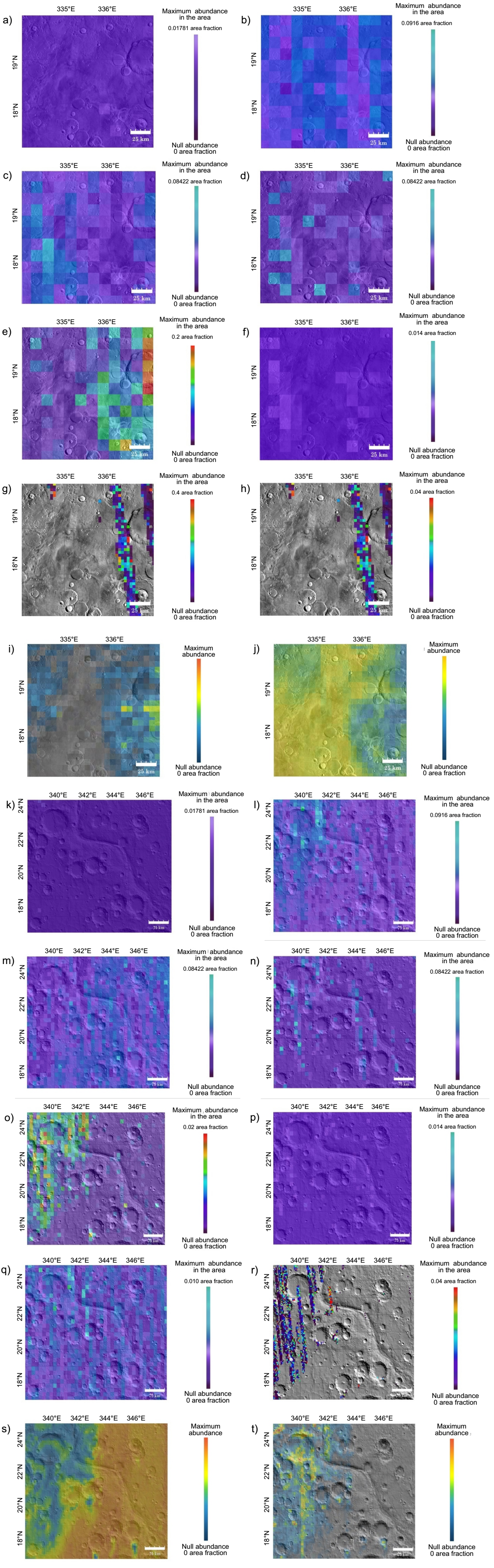
Figure 3 a) Abundance of amphibole detected with TES on Oxia Planum. Only a little of this mineral is observed around the possible delta. b) Carbonate abundance (calcite and dolomite) detected with TES on Oxia Planum. Purple tones indicate null abundance and blue tones indicate a greater detection of these minerals. c) Possible implications of potassium feldspar (microcline) detected with TES on Oxia Planum. The darker purple range of colors represents the lowest abundance and the brightest blues the highest abundance of this mineral on Oxia Planum. d) The map represents the surface abundance of hematite detected with TES on Oxia Planum, where purple tones indicate no hematite was detected in that area and blue tones indicate slight abundance. e) Surface abundance of plagioclase on Oxia Planum detected with TES. The color scale represents the abundance of plagioclase, from the lowest abundance in shades of purple to high (red). f) Silica (quartz) abundance detected with TES on Oxia Planum. There is a minimal, almost non-existent presence of this mineral which is seen as lighter shades of purple. g) Sulfate abundance (anhydrite and gypsum) detected with the TES instrument on Oxia Planum. h) Total olivine abundance on Oxia Planum for all forsterite (Mg2SiO4) compositions. Is observed that there is only olivine in the eastern part of the region. TES map. i) Pyroxene abundance on Oxia Planum detected with the OMEGA instrument. Pyroxenes are particularly widespread in the cratered highlands, pointing to some of the oldest parts of the planet's crust. j) Ferric oxide abundance on Oxia Planum detected with OMEGA. It is not specified which mineral, but it is probably hematite or magnetite. k) Amphibole abundance detected with TES on Mawrth Vallis. Is observed that there is practically nothing of this mineral in the area. l) Carbonate abundance (calcite and dolomite) with TES on Mawrth Vallis. Purple tones indicate null abundance and blue tones indicate a greater detection of these minerals. m) Surface abundance of potassium feldspar (microcline), detected with TES on Mawrth Vallis. The range of darker purple colors indicates the lowest abundance and the brightest blues the highest abundance of this mineral. (n) Surface abundance of hematite on Mawrth Vallis detected with TES. Purple tones indicate no hematite was detected in that area, and blue tones indicate slight abundance. There is little hematite content in the area, and it is evenly distributed. o) Surface abundance of plagioclase endmembers, detected with TES on Mawrth Vallis. It is in the western part where there is more content. p) Silica (quartz) abundance on Mawrth Vallis detected with TES. There is minimal to no presence of this mineral which is seen as lighter shades of purple. q) Sulfate abundance (anhydrite and gypsum) on Mawrth Vallis detected with TES. The abundance of sulphates is not very high; is in the northwestern part where the highest content is found. r) Olivine surface abundance on Mawrth Vallis, detected with TES, for all forsterite compositions (Mg2SiO4), it is observed that there is only olivine in the western part of the region. s) Ferric oxide abundance on Mawrth Vallis detected with OMEGA. It is not specified which mineral, but it is probably hematite or magnetite. t) Pyroxene abundance on Mawrth Vallis, detected with OMEGA. Pyroxenes are particularly widespread in the cratered highlands, pointing to some of the oldest parts of the planet's crust. The color scale represents the abundance of pyroxene, from low (blue) to high (red). a-j) THEMIS Day IR 100m Global Mosaic map; k-t) MOLA Shaded Relief Map (NE).
In the TES global map of abundance of carbonates, calcite (CaCO3) and dolomite (CaMg (CO3)2), weak signatures of these minerals can be observed (Figure 3b), however, they are important because they could indicate that the planet had a neutral or alkaline pH when these minerals were formed and that there were humid environments. There is presence of potassium feldspar (KAlSi3O8 microcline), a characteristic mineral of granites and syenites formed at great depth (Figure 3c).
Other minerals such as hematite (Figure 3d), plagioclase (Figure 3e), quartz (Figure3f), and some type of sulfate (Figure 3g) also generated TES maps of varied abundances.
There are olivine detections (Figure 3h) made with TES and pyroxenes (Figure 3i) with OMEGA data. We also found ferric oxide (Figure 3jj), it does not specify the mineral, but it is probably hematite or magnetite.
Comparing and integrating the mineralogy of the area detected in previous studies, we see that Quantin et al., (2014) and Quantin-Nataf et al., (2019) have detected mainly phyllosilicates in this area. Fe/Mg-rich phyllosilicates have previously been shown to occur extensively throughout the landing area (Mandon, et al., 2021). Oxia Planum has one of the largest clay units on Mars and was originally detected with data from the OMEGA instrument. Additional analyzes using the CRISM data (100-200 m/pix) have further refined the unit's contacts and mineralogy.
In the center of the region, absorption lines match values for vermiculite, saponite, and olivine and to the southeast of Oxia Planum, CRISM detected seven signatures matching those of minerals such as olivine, montmorillonite, kaolinite, saponite (absorptions bands 1.40-1.42 m, 2.30-2.32 m and 2.4 m) vermiculite (absorption bands at 1.42 m, 2.30-2.31 m, and 2.39 m), see Carter et al., (2013), nontronite and opal. Further south in the region, a mixture of jarosite, kaolinite, montmorillonite, nontronite, saponite, and vermiculite was detected.
Remarkably uniform spectral features consistent with an Fe/Mg-rich phyllosilicate type were observed in the study by Carter et al., (2016). The positions and shapes of the bands fit better with smectite (Fe-Mg rich saponite) or smectite/mica (e.g. vermiculite) type clays, but not nontronite (Al-Fe smectite). The latter is located further east at Mawrth Vallis.
According to De Sanctis, et al., (2022) the bedrock unit identified in Oxia Planum is one of the largest exposures of clays on Mars and belongs to a broader detection extending further westward in Arabia Terra and northward to Mawrth Vallis (Loizeau et al., 2007; Bishop et al., 2008; McKeown et al., 2009; Noe Dobrea et al., 2010). In some areas of Oxia Planum, HiRISE shows absorption bands at about 1.4, 1.9, 2.3, and 2.4 μm, interpreted as typical of Fe/Mg-rich phyllosilicate (smectite clays, likely Fe/Mg-rich saponite, or smectite/mica, e.g., vermiculite; Carter et al., 2016). In some locations, an additional spectral absorption near 2.5 μm has been identified and suggests the presence of other phyllosilicate minerals or carbonates (Brossier et al., 2022).
Although at the limit of sensitivity of orbital instruments the clays in Oxia Planum have been shown to be the most representative of Mars in terms of geographic distribution, many large clay units are richer in nontronite.
Mawrth Vallis mineralogy
The OMEGA and CRISM spectrometers have detected phyllosilicates in layered deposits around Mawrth Vallis. In this region of Mars, observed layer colors often correlate with different water-related minerals, so the diversity of colors seen in available images may reflect a dynamic environment at this location on early Mars, this supported by McKeown et al., (2009).
There are amphibole (Figure 3k) detections in Mawrth Vallis, this mineral practically does not exist in the area, but there are some points where a slight detection is observed.
An abundance of calcite and dolomite (Figure 3l) are observed in the TES global map, as mentioned above, they could indicate that the planet had a neutral or alkaline pH when these minerals were formed and that there were humid environments.
There are also slight signatures of minerals such as potassium feldspar (see Figure 3m) (KAlSi3O8 microcline), hematite (Figure 3n), plagioclase (Figure 3o), quartz (Figure3p) and sulphates (Figure 3q). Olivine is detected in the figure 3r (all forsterite compositions), ferric oxide (Figure 3s) and pyroxene (Figure 3t).
In previous studies the zone contains several mineral components including montmorillonite, opal, kaolinite/halloysite, and zeolite (Bishop et al., 2013). In Bishop and Rampe (2020) and Bishop et al., (2014, 2020) they detect allophane and imogolite. Wray et al., (2010) detected Ca-sulphate bassanite in the floor of the Mawrth Vallis channel. In the western part of Mawrth Vallis, Bishop et al., (2008) detected a large area (>10 km) with the presence of phyllosilicates in CRISM spectra. The bands coincide with smectites such as nontronite or hectorite. The possible presence of montmorillonite, illite, including chalcedony and glauconite is also reported used CRISM data covering the northern part of the Mawrth Vallis region to find a new exposure of jarosite and copiapita. Analyzing CRISM data, comparisons of these spectra with those of the spectral library indicate the presence of rozenite, melanterite, copiapite and ferricopiapite.
Allophane and imogolite are aluminosilicates commonly detected in well-drained soils derived from volcanic ash containing feldspar and pyroxene. Continued weathering of soils rich in these minerals can produce kaolinite/halloysite or montmorillonite, observed at Mawrth Vallis. CRISM spectra of the upper clay unit at Mawrth Vallis show variations in the 1.9 and 2.2 μm bands indicating the presence of multiple mineral phases. Many spectra are consistent with allophane or imogolite (Bishop et al., 2014).
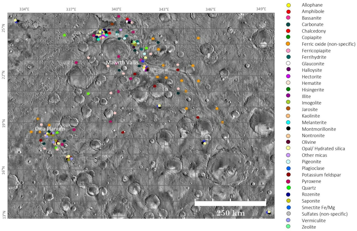
We register 35 mineral species-carbonates, oxides, sulphates, and silicates-detected with CRISM, OMEGA and TES (see Table 1). We produced a mineral map where we integrate the mineralogical species, included those that had been previously reported (Figure 4).
Table 1 List of the minerals identified in both studied zones in previous studies and the minerals observed in this study.
| Mineral | Oxia Planum | Mawrth Vallis | Detected by instrument | Reference |
|---|---|---|---|---|
| Allophane | yes | CRISM | Bishop et al.,(2013;2014) | |
| Amphibole | yes | yes | TES | JMARS Maps (this study) |
| Bassanite | yes | CRISM | Wray et al., (2010) | |
| Carbonate | yes | yes | TES | JMARS Maps (this study); Brossier et al., (2022) |
| Copiapite | yes | CRISM | Farrand et al., (2014) | |
| Ferricopiapite | yes | CRISM | Farrand et al., (2014) | |
| Ferrihydrite | yes | TES | Viviano & Moersch (2013) | |
| Glauconite | yes | CRISM | Bishop et al., (2008) | |
| Halloysite | yes | CRISM | Bishop et al., (2013) | |
| Hectorite | yes | CRISM | Bishop et al., (2008) | |
| Hematite | yes | yes | TES | JMARS Maps (this study) |
| Illite | yes | CRISM | Bishop et al., (2008) | |
| Imogolite | yes | CRISM | Bishop et al.,(2013;2014) | |
| Jarosite | yes | yes | CRISM, OMEGA | Quantin-Nataf et al., (2019); Farrand et al., (2014) |
| Kaolinite | yes | CRISM, OMEGA | Quantin-Nataf et al., (2019); Bishop et al., (2013) | |
| K-feldspar | yes | yes | TES | JMARS Maps (this study) |
| Melanterite | yes | CRISM | Farrand et al., (2014) | |
| Montmorillonite | yes | yes | CRISM, OMEGA | Quantin-Nataf et al., (2019); Bishop et al., (2013) |
| Nontronite | yes | yes | CRISM, OMEGA | Quantin-Nataf et al., (2019); Carter et al., (2016) Bishop et al., (2008) |
| Olivine | yes | yes | TES, OMEGA, CRISM | JMARS Maps (this study) |
| Opal | yes | CRISM, OMEGA | Quantin-Nataf et al., (2019); Bishop et al., (2013) | |
| Plagioclase | yes | yes | TES | JMARS Maps (this study) |
| Pyroxene | yes | yes | TES | JMARS Maps (this study) |
| Quartz | yes | yes | TES | JMARS Maps (this study) |
| Rozenite | yes | CRISM | Farrand et al., (2014) | |
| Saponite | yes | CRISM, OMEGA | Quantin-Nataf et al., (2019); Carter et al., (2016) | |
| Smectite | yes | OMEGA | Carter et al., (2016) | |
| Vermiculite | yes | CRISM, OMEGA | Quantin-Nataf et al., (2019); Carter et al., (2016) | |
| Zeolite | yes | CRISM | Bishop et al., (2013) |
DISCUSSION
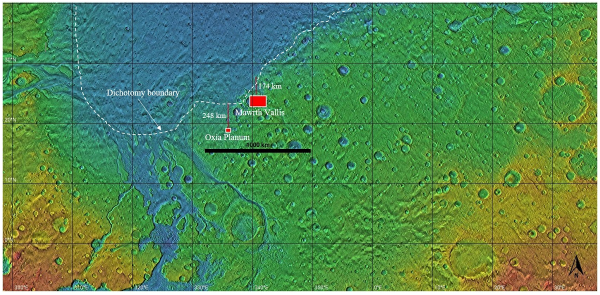
Sites located at the boundary of the dichotomy generally exhibit fluvial features and hydrated minerals (e.g. Farley et al., 2022). Observing Figure 5 is notable that Oxia Planum and Mawrth Vallis are located in this region (at a distance from the boundary of approximately 248 and 174 km respectively). What makes them sites of high interest to know the behaviour of the different Martian terrains.
Mineralogical significance and geological occurrence
The secondary minerals found in the study areas are the ones that give us the main clues about the conditions of ancient Mars, 3.5-4.0 Ga ago. Water must have been present in the surface and subsoils, causing direct precipitation and transformation to secondary minerals. For example, phyllosilicates in Noachian-age exposures preserve widespread evidence of hydrothermal and diagenetic aqueous environments.
According to occurrence on Earth and taking as reference the mineralogical classification of Klein, (2002), Figure 6 integrates the possible origins, pH, and under what type of paleoenvironments the reported minerals might have precipitated. A hydrothermal origin seems to be the most probable given the mineral associations observed in the study areas. Hydrothermal activity is likely to have been driven by impacts or magmatic processes, just as happens on Earth (Pirajno, 2009). Having evidence of a nearby impact (Oyama crater) reinforces the idea of impact-driven hydrothermal activity. Phyllosilicates and sulphates could have originated in this type of environment. Oyama sprung up from an impact on a Fe/Mg unit, which suggests that the deposits adjacent to the crater and near the channel may been impact-generated hydrothermal.
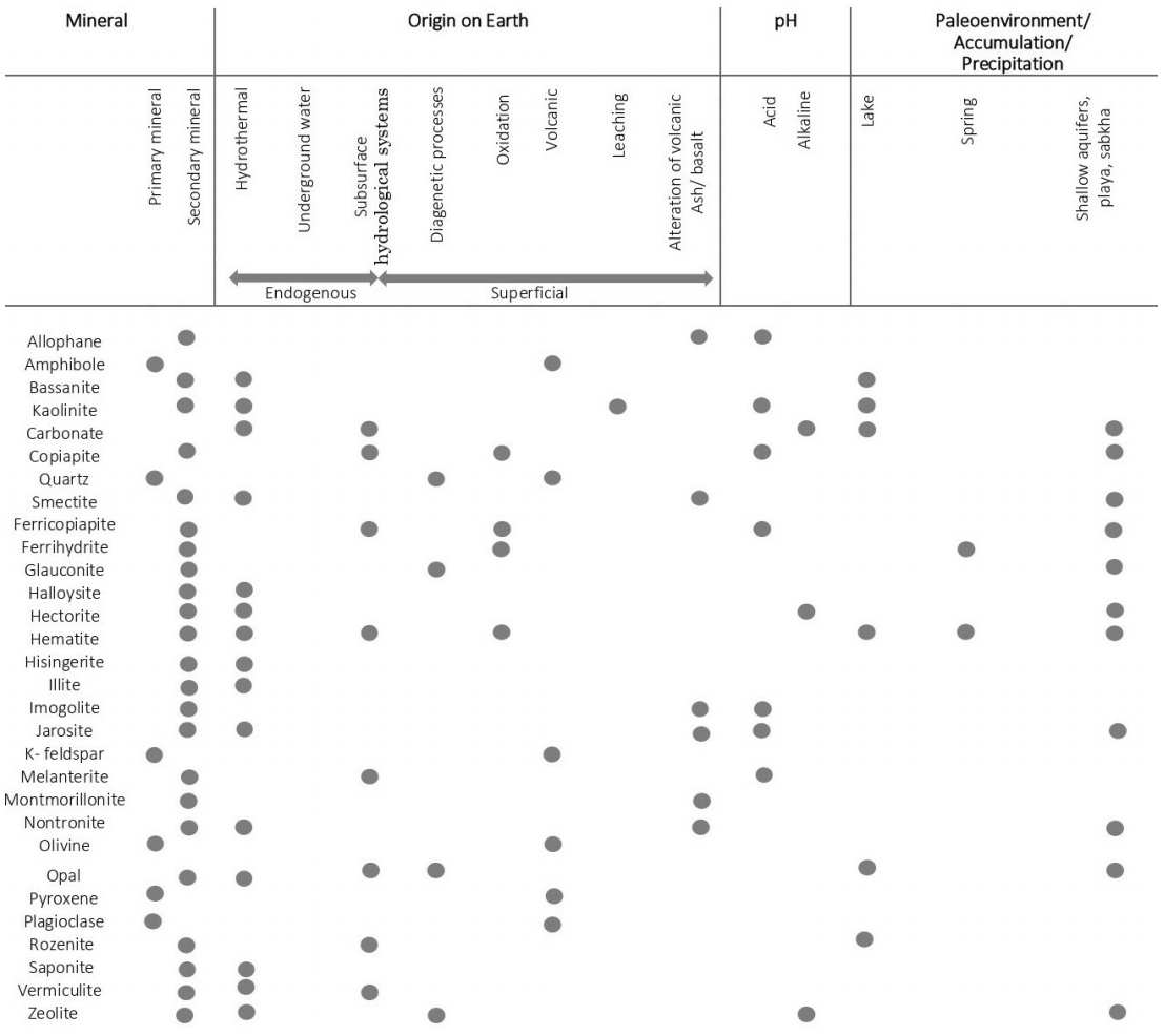
Figure 6 Diagram of the minerals found in Oxia Planum and Mawrth Vallis. Showing the most common origins, the pH, and where they accumulate or precipitate, according to Klein, (2002).
Over the surface, minerals might have been formed in sporadic, short-term, hot, and humid environments, during a generally cold period on early Mars. The Mawrth Vallis channel can be that kind of environment which, given its formation, only requires catastrophic water discharges during short periods of time (days or weeks). On the other hand, clays (e.g., nontronite) need long-term water-rock interaction. According to Michalski et al., (2022), most Martian palaeolakes date to the Noachian (>3.7 Ga) and probably lasted ~102-106 years, representing only a small fraction of the ~400 Ma of Noachian time. These described minerals potentially preserve features of the ancient atmosphere and climate.
Coexistence of carbonates, oxides, silicates and sulphates
Carbonates, sulphates, oxides and silicates do not usually form simultaneously. It is very likely that these minerals formed at different times, as climatic conditions changed. Another possibility is that they materialized simultaneously, but some of them in the subsoil of the planet and others, on its surface (Martínez-Frías et al., 2004).
Some minerals require very acidic pH conditions for their generation-below 6, like the jarosite (Farrand et al., 2009). The presence of jarosite would therefore be incompatible with that of carbonates, as the latter emerge in environments with alkaline pH. However, these associations appear even on Earth (eg. Jaroso, Spain) (Martínez-Frías et al., 2004).
According to Poulet et al., (2005) Earth-like conditions existed in early Mars (before 3.5 Ga). Later in Martian history, the surface became more acidic due to volcanism, which suppressed the formation of phyllosilicates and carbonates, leading to the formation of minerals that required acidic conditions -such as hematite and the detected sulphates.
The fact that these diverse types of minerals are present in the same outcrop is related to different hydrothermal and alteration stages (Martínez-Frías et al., 2004). In addition, this probably indicates the time overlap of sundry episodes and mineralogenetic processes.
Water presence
In all the scenarios where the afore mentioned minerals originate, liquid water is required. Within the boundaries of Oxia Planum and Mawrth Vallis, there is evidence of geoforms that include valley networks, overflow channels, even deltas, which support occurrence of episodic liquid water or releases of water from underground reservoirs.
In the subsurface and mostly out of contact with the atmosphere, the formation of phyllosilicates and other minerals took place, occasionally, at elevated temperatures. Furthermore, geomorphological evidence of late Noachian open-basin lakes, valley networks, and outlet channels demonstrate, the episodic presence of liquid water on the Martian surface (Ehlmann et al., 2011 and Bishop et al., 2020). The origin of the water is not clear, but it was considered possible that it could have derived from frozen, molten, and mobilized aquifers as a result of tectonism and/or magmatic heat (Pirajno., 2009).
On Earth, geological environments -where the minerals detected in this work commonly form and precipitate- include subaerial, underwater, and shallow subsurface hydrothermal systems, cold springs, alkaline lakes, sabkhas, and playas. These palaeoenvironments could probably have existed on Mars.
Astrobiological implications
Minerals are not only indicators of the physical-chemical configuration of different environments and their subsequent changes, but they can also play a crucial astrobiological role (Martínez-Frías et al., 2006). In the study sites, the dominant mineral group is the phyllosilicates. Some of these minerals like the smectites or illites, detected from the orbit of Mars, indicate they formed in a neutral pH environment, which would have been favourable for life. Albeit, there are also acidophilic microorganisms that can adapt in extreme pH conditions, similar to the conditions where some sulphates or oxides are formed.
Potential locations where primitive life could have emerged include spots where fossil or active hydrothermal systems may be present (Farmer, 2000). Life on Earth probably began in hydrothermal systems and, from the abundant proof of the existence of hydrothermal environments on Mars, it could be inferred, that life could have originated at the same time and in similar conditions (Osinski et al., 2013).
CONCLUSIONS
The study sites show an intriguing mineralogical diversity, with mineral species corresponding to the groups of carbonates, oxides, silicates, and sulphates. The dominant mineral group is the phyllosilicates. Some of these minerals like the smectites or illites also detected in Mars orbit indicate a neutral pH genesis environment. There is substantial uncertainty involved in any remote sensing study, and this must be recognized when considering the results of this study.
At both landing sites we describe the coexistence of minerals formed in both acidic and alkaline environments, suggesting that solution pH was likely heterogeneous throughout Martian history and dependent on the local environment. From this, we can extrapolate that initial conditions on Mars were like those on Earth with carbonates and phyllosilicates precipitating. During later Martian history, the surface appears to have become more acidic, suppressing the formation of phyllosilicates and carbonates, leading to the observed hematite and sulphates. In the Hesperian (3.9-2.7 Ga) episodic volcanism changed the Martian climate, creating acid rain due to the reaction of sulphur emitted by volcanoes in contact with water.
In the Oxia Planum and Mawrth Vallis vicinity, shallow subaerial, subaquatic, and subsurface hydrothermal systems, cold springs, alkaline lakes, sabkhas, and playas may have developed. Localized hydrothermal circulation could drive persistent groundwater outflow, which is consistent with the morphology and distribution of the valleys observed in the landing sites. This study contributes to the understanding of the mineralogy of Mars and the implications that water had on the formation of carbonates, oxides, silicates, and sulphates.

