Articles
Hydrological alterations in semi-arid river systems: an exploratory approach to natural and anthropogenic drivers
Alteraciones hidrológicas en sistemas fluviales semiáridos: un enfoque exploratorio sobre factores naturales y antropogénicos
Bastidas, Luis Bernardo*+
 http://orcid.org/0000-0002-8570-9734
Juan Vich, Alberto Ismael**
http://orcid.org/0000-0002-0477-2476
Henao, Ángela María***
http://orcid.org/0000-0002-7949-7018
http://orcid.org/0000-0002-8570-9734Juan Vich, Alberto Ismael**
http://orcid.org/0000-0002-0477-2476Henao, Ángela María***
http://orcid.org/0000-0002-7949-7018
-
Publication dates-
July 02, 2025
April , 2025
- Article in PDF
- Article in XML
- Automatic translation
- Send this article by e-mail
- Share this article +
Abstract
Given that the Atuel river falls under the jurisdiction of two provinces, water conflicts in this arid region have generated controversy for several years. Within the context of hydrographic analysis and the complexities of landscapes, geography becomes crucial as it links the fluvial and social dynamics and their interactions within the territory. This study aims to provide an exploratory approach to the river flows as they pass through the province of Mendoza, facilitating an understanding of the natural and anthropic effects on the river. Conventional exploratory data analysis tests (normality, randomness, independence, and homogeneity) were employed to analyze hydrological measurements, with the results being physically interpreted and related to the fluvial environment. The results confirmed the anthropic impacts contributing to the hydrographic alteration of the Atuel river, as evidenced by differences between the upstream and downstream stations affected by human activities. Thus, it can be inferred that the river regime and the landscapes towards the end of the water system in Pampean lands have been altered by consumptive water uses, in addition to storage in existing dams.
Keywords::
exploratory data analysis, water conflicts, anthropic impacts, arid zones, river regime alteration
INTRODUCTION
Hydrological alterations in rivers have been widely studied due to their impact on aquatic ecosystems and the availability of water resources for various human uses. It has been demonstrated that maintaining natural flow regimes is essential for preserving biodiversity and ensuring the functionality of river systems (Poff et al., 1997; Richter et al., 2003). Globally, several studies have analyzed the combined effects of natural and anthropogenic factors on river hydrology, including changes in flow regimes due to reservoir regulation, water diversion for irrigation, and the impacts of climate change (Nilsson et al., 2005; Döll & Zhang, 2010).
-
Richter et al., 2003Ecologically sustainable water management: managing river flows for ecological integrity. Ecological ApplicationsEcological Society of America, 2003
-
Nilsson et al., 2005Fragmentation and Flow Regulation of the World's Large River SystemsScience, 2005
-
Döll & Zhang, 2010Impact of climate change on freshwater ecosystems: a global-scale analysis of ecologically relevant river flow alterationsEuropean Geosciences Union, 2010
Several examples include the Colorado river in the United States, where dam construction has drastically reduced downstream flows, altering riparian ecosystems and affecting water-dependent communities (Christensen et al., 2004). Similarly, the Yangtze river in China has experienced significant changes in its flow regime due to the operation of the Three Gorges Dam, impacting aquatic biodiversity and sediment dynamics (Zhang et al., 2016). In South America, the Paraná river system has been affected by multiple hydroelectric dams, leading to disruptions in river connectivity and alterations in natural flooding patterns (Agostinho et al., 2008).
-
Christensen et al., 2004The Effects of Climate Change on the Hydrology and Water Resources of the Colorado River BasinClimatic Change, 2004
-
Zhang et al., 2016Impact of the Three Gorges Dam on the Hydrology and Ecology of the Yangtze RiverWater, 2016
-
Agostinho et al., 2008Dams and the fish fauna of the Neotropical region: impacts and management related to diversity and fisheriesBraz. J. Biol., 2008
In Argentina, a relevant case is the Ramsar site Lagunas de Guanacache, Desaguadero y del Bebedero, located in Mendoza and primarily fed by flows from the Mendoza and San Juan rivers. Since the colonial period, and especially after the construction of dams on both rivers, their flows have diminished, contributing to the economic development of irrigated oases at the expense of downstream riverine and wetland ecosystems (Ramsar site), resulting in evident anthropogenic hydrological alterations (Bastidas, 2023; Bastidas et al., 2024).
-
Bastidas, 2023Caudal ambiental en el sitio Ramsar Lagunas de Guanacache, Desaguadero y del Bebedero, Argentina, 2023
-
Bastidas et al., 2024Los descendientes de los Huarpes y su nexo con los humedales áridos de Cuyo, ArgentinaRevista Notas Históricas y Geográficas, 2024
Within the arid South American diagonal and the dry central-western region of Argentina, the Atuel river represents the third-largest flow in the region by discharge volume (Lauro et al., 2016). Its springs, located in the Andean foothills, allow it to be fed by melting snow and glaciers, providing perennial flows throughout the year under natural conditions (Sarafian, 2006; Cazevane, 2015).
-
Lauro et al., 2016Variabilidad del régimen fluvial en cuencas de la región de CuyoGeoacta, 2016
-
Sarafian, 2006Cuenca Del Atuel, 2006
-
Cazevane, 2015La cuenca del río Desaguadero: un caso de desertificación por acción antrópicaInterespaço, revista de Geografía e Interdisciplinaridade, 2015
Downstream from the mountain range, the river irrigates vast areas of cultivated land, passes through dry forests, marshlands (low wetlands of high ecological value), and salt flats before naturally flowing into the Colorado river, a tributary of the Atlantic Ocean (Cazevane, 2015). Politically and administratively, the Atuel crosses (in the direction of flow) the Argentine provinces of Mendoza and La Pampa.
-
Cazevane, 2015La cuenca del río Desaguadero: un caso de desertificación por acción antrópicaInterespaço, revista de Geografía e Interdisciplinaridade, 2015
The river's interprovincial nature and the conflicting interests between these provinces led to a decades-long legal dispute, culminating in a ruling by the National Supreme Court of Justice in July 2020 (CSJN, 2020). The court mandated that Mendoza must deliver a continuous flow of 3.2 m³/s (9.2 % of the mean annual daily flow) to La Pampa, requiring a cooperation agreement among the involved stakeholders. This ruling implies that the province of Mendoza must regulate its activities (such as irrigation and hydroelectricity) to allow the stipulated flow to reach La Pampa.
-
CSJN, 2020Fallo CSJ 243/2014 (50-L)/CS1, 2020
Although the issue extends beyond the stipulated flow and its adequacy, it underscores the importance of hydrological analysis and its connection with geography as a means of understanding and explaining natural phenomena, social dynamics, and their implications for the territory.
In this context, the aim is to provide an exploratory interpretation of the Atuel river flows as they pass through the province of Mendoza, to better understand its characteristics and their relationship with the surrounding environment. Although this study is exploratory, it is driven by several hypotheses that shaped the analytical approach. First, it is hypothesized that variations in the Atuel river's flow regime are significantly influenced by both natural factors (such as seasonal meltwater and precipitation patterns) and anthropogenic interventions (including water extraction for irrigation and the operation of hydroelectric plants). Second, it is expected that these alterations in flow dynamics have led to measurable ecological impacts on the surrounding areas.
Lastly, the study hypothesizes that the ongoing legal and political conflict between the provinces of Mendoza and La Pampa is, at least in part, a result of these hydrological changes, which affect water availability and riverine health. These hypotheses will be examined by exploratory-statistical methods that allow for a detailed analysis of the river’s flow characteristics and their broader implications.
METHODOLOGY
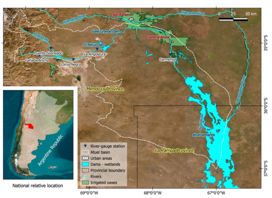
Regarding the study area, the Atuel river basin is part of the Colorado river hydrographic system. The basin, located to the east of the Andes mountain range, allows water to flow from west to east, thereby influencing the orientation of agricultural activities and urban settlements along the river's axis, which extends approximately 417 km on the Mendoza side and 220 km on the Pampean side.
The study area (Figure 1) is situated in the central-western region of Argentina, specifically between southern Mendoza province and northwestern La Pampa province, within the coordinates 34º27'42'' S to 37º00'02'' S and 70º04'26'' W to 66º45'04'' W.
Thumbnail
 Source of data: SIPHN (2019). Source: author's elaboration.
Figure 1
Hydrometric stations and hydrography. Atuel river basin.
Hydrometric stations and hydrography. Atuel river basin.
The basin was delineated to encompass the entire watershed, extending to the Atuel wetlands in La Pampa, without subdivision into sub-basins for each gauge station (Figure 1).
Four gauge stations were considered along the Atuel river: La Angostura (LAN), Puente El Sosneado (ESO), Loma Negra (LNE), and Carmensa (CAR), with the last one located downstream of the irrigated oasis. Additionally, the Cañada Ancha (CAN) gauge station, located on the Salado river (a tributary of the Atuel river), was also included. Average daily flows (Figure 1) were analyzed over a 34-year period, from 1985 to 2019 (except for the Carmensa station, which has 23 years of data, from 1996 to 2019). These daily measurement stations are part of the Integrated Hydrological Database managed by the Secretariat of Infrastructure and Water Policy of Argentina (SIPHN, 2019). The selected analysis period aims to maximize the length of data shared among the stations with the lowest percentage of missing data.
-
SIPHN, 2019Base de datos hidrológica integrada, 2019
Additionally, an Exploratory Data Analysis (EDA) was conducted, with the purpose of examining the data prior to applying any advanced statistical techniques (Hirsch et al., 1982). This process, in addition to verifying the properties and basic characteristics of the series used, allows the results to be linked with processes that may be associated with the nature of the data.
-
Hirsch et al., 1982Techniques of Trend Analysis for Monthly Water Quality dataWater Resources Research, 1982
Initially, daily missing data was estimated using different procedures depending on the length of the information gap. For gaps of up to three missing days, a third-degree Lagrange interpolating polynomial was employed (Gyau-Boakye and Schultz, 1994). If the gap extended between 4 and 20 days, a first-order autoregressive model with correction was applied (Gyau-Boakye, 1993). Finally, for gaps longer than 20 days, the MOVE (Maintenance of Variance Extension) method was used (Hirsch et al., 1982).
-
Gyau-Boakye and Schultz, 1994Filling gaps in runoff time series in West AfricaHydrological Sciences Journal, 1994
-
Gyau-Boakye, 1993Filling gaps in hydrological runoff data series in West Africa, 1993
-
Hirsch et al., 1982Techniques of Trend Analysis for Monthly Water Quality dataWater Resources Research, 1982
After filling in the missing data for each daily average flow series, average flow values were calculated for the 12 months of the year. Additionally, the four climatic seasons (winter [JJA], spring [SON], summer [DJF], and fall [MAM]), an annual runoff value, six percentiles of the flow duration curve (Q10, Q30, Q90, Q180, Q270, Q355), and two extreme values (minimum and maximum) were also considered. In total, 25 measurements were analyzed.
The tests were based on fundamental statistical assumptions, including the verification of normality, randomness, and independence, as well as homogeneity, which indicates the regularity of data around the mean, the fluctuations of the variable, and the statistical dependency ratio, respectively. Additionally, tests were conducted to detect outliers. These tests, applied in the hydrographic context, can reveal characteristics that may influence the intrinsic nature of the watercourse.
Normality, Randomness and Independence
To verify whether a data series is linked to a standard normal population distribution, the skewness and kurtosis tests were applied (Snedecor and Cochran, 1962, cited in Salas, 1992). Regarding randomness, the non-parametric Runs and Kendall tests were used (McGhee, 1985, cited in Adeloye and Montaseri, 2002), while for independence, the Bartlett (parametric) and Von Neumann (non-parametric) tests were applied (Kundzewicz and Robson, 2000). A significance level of 5 % was used for all tests. If either of the two tests rejects the null hypothesis, it is considered sufficient to accept the alternative hypothesis for each condition.
-
Salas, 1992Analysis and modelling of hydrologic time series, 1992
-
Adeloye and Montaseri, 2002Preliminary streamflow data analyses prior to water resources planning studyJournal of Hydrological Science, 2002
-
Kundzewicz and Robson, 2000Detecting Trend and Other Changes in Hydrological Data, 2000
Homogeneity analysis
For trend detection, both parametric and non-parametric tests were applied, considering the series conditions and the underlying assumptions of the tests. The tests used were the Student’s Parametric t-test (Remington & Schork, 1974), Spearman Rank Order Correlation (Kundzewicz and Robson, 2000), and Mann-Kendall (Hirsch et al., 1982; Westmacott & Burn, 1997). In all tests, a significance level of α = 0.05 was used.
-
Remington & Schork, 1974Estadística Biométrica y Sanitaria, 1974
-
Kundzewicz and Robson, 2000Detecting Trend and Other Changes in Hydrological Data, 2000
-
Hirsch et al., 1982Techniques of Trend Analysis for Monthly Water Quality dataWater Resources Research, 1982
-
Westmacott & Burn, 1997Climate change effects on the hydrologic regime within the Churchill-Nelson river BasinJournal of Hydrology, 1997
To detect the presence of abrupt changes in the flow series, the Student’s t parametric test and several non-parametric tests were applied, such as the Rank Sum or Mann-Whitney (1947), Pettitt (1979), Buishand (1982), and Worsley (1979). These tests detect a single point of change, and in some cases, the trend must be eliminated previously. The significance level for these tests was 5 %.
-
Mann-Whitney (1947)On a Test of Whether one of Two Random Variables is Stochastically Larger than the OtherThe Annals of Mathematical Statistics, 1947
-
Pettitt (1979)A nonparametric approach to the change-point problemApplied Statistics, 1979
-
Buishand (1982)Some methods for testing the homogeneity of rainfall recordsJ. Hydrology, 1982
-
Worsley (1979)On the likelihood ratio test for a shift in location of normal populationsJ. Am. Statistic As., 1979
Finally, regarding outliers, the Grubbs (EPA, 2000), Interagency Advisory Committee on Water Data (1982) (formerly WCR), Rosner (EPA, 2000), and MAD-score (median absolute deviation) tests (Leys et al., 2013; Bae and Ji, 2019) were used for the annual mean values of the measurements considered (except for the percentiles of the flow duration curve).
-
Leys et al., 2013Detecting outliers: Do not use standard deviation around the mean, use absolute deviation around the medianJournal of Experimental Social Psychology, 2013
-
Bae and Ji, 2019Outlier Detection and Smoothing Process for Water Level Data Measured by Ultrasonic Sensor in Stream FlowsWater, 2019
The MAD-score method, which uses the median instead of the mean, offers advantages in handling the sensitivity to outliers. Miller (1991) and Leys et al. (2013) establish three decision criteria, ranging from “low” to “very” conservative, providing greater robustness to the method.
-
Miller (1991)Reaction time analysis with outlier exclusion: Bias varies with sample sizeThe Quarterly Journal of Experimental Psychology, 1991
-
Leys et al. (2013)Detecting outliers: Do not use standard deviation around the mean, use absolute deviation around the medianJournal of Experimental Social Psychology, 2013
Given the advantages described for the MAD-score method, the other tests were applied to verify their results, corroborating the presence or absence of a value as an outlier.
RESULTS
Normality
The Puente El Sosneado, Loma Negra, and La Angostura stations exhibit significant normality in 70 % of the daily measurements considered. This percentage decreases to 40 % for the Cañada Ancha station (Salado river) and to 24 % at the Carmensa station (at the exit of the irrigation oasis) (Table 1). In the case of the Carmensa station, the lack of normality in most measurements may be attributed to the high level of water use in the Atuel river, which is at its maximum at the station's gauging point (the end of the irrigated oasis).
Table 1
Percentage of daily measurements with and without the presence of Normality, Randomness and Independence. Green color expresses the acceptation of Ho, while red means its rejection.
Percentage of daily measurements with and without the presence of Normality, Randomness and Independence. Green color expresses the acceptation of Ho, while red means its rejection.
| Normality | Randomness | Independence | ||||
| Gauge Station | % | % | % | % | % | % |
| ESO | 76 | 24 | 16 | 84 | 20 | 80 |
| LNE | 68 | 32 | 44 | 56 | 0 | 100 |
| LAN | 80 | 20 | 20 | 80 | 4 | 96 |
| CAN | 36 | 64 | 44 | 56 | 28 | 72 |
| CAR | 24 | 76 | 68 | 32 | 92 | 8 |
| Gauge Station | % | % | % | % | % | % |
| ESO | 76 | 24 | 16 | 84 | 20 | 80 |
| LNE | 68 | 32 | 44 | 56 | 0 | 100 |
| LAN | 80 | 20 | 20 | 80 | 4 | 96 |
| CAN | 36 | 64 | 44 | 56 | 28 | 72 |
| CAR | 24 | 76 | 68 | 32 | 92 | 8 |
Additionally, this station shows an irregular flow pattern, different from that of upstream stations on the same river, possibly due to anthropogenic activities. On the other hand, the situation at Cañada Ancha may be associated with the torrential regimes typical of a mountain river, such as the Salado river, and the hydrological variability it entails.
Randomness
According to the World Meteorological Organization (WMO, 2011), from a hydrological perspective, randomness implies that fluctuations in the variable are due to natural causes rather than anthropogenic effects. However, it is notable that the station with the greatest randomness in its measurements (68 %) is Carmensa. Although this station records the drainage from irrigated areas as well as the remaining flows released from upstream dams, the observed randomness may be attributed to the statistical inconsistency caused by this situation (Table 1).
On the one hand, the other Atuel river stations (upstream) exhibit more than 60 % lack of randomness in their measurements, particularly pronounced during the months with higher water demand in the irrigated oases (summer and spring). On the other hand, it is notable that all stations show an absence of randomness in the winter and annual measurements, highlighting the anthropogenic impact of water use in the area (reservoirs and irrigation).
Independence
The Puente El Sosneado, Loma Negra, and La Angostura stations reject the null hypothesis (presence of independence) in more than 80 % of the 25 measurements considered (Table 1). This situation may occur because these stations monitor the same river, which also has an upper basin with significant glacial reservoirs (Falaschi et al., 2018). In contrast, the Carmensa station exhibits independence in 92 % of the measurements.
-
Falaschi et al., 2018Balance de masa geodésico 2000-2011 de los glaciares de la cuenca del río Atuel, Andes Centrales de Mendoza (Argentina)Geoacta, 2018
Although Carmensa is located on the Atuel river, being at the exit of the irrigated oasis means that the flow of water (altered by anthropogenic activities) does not statistically depend on natural runoff, as observed at the upstream stations of the Atuel river. A notable aspect of Carmensa is the absence of independence in winter, likely due to it being the season with the lowest agricultural production, minimal water use, and thus the highest reliance on natural flows from the Atuel.
Additionally, the Cañada Ancha station shows 44 % independence in its measurements. Although this station is located upstream of the irrigation system, its basin is nearly three times smaller than the Atuel’s basin at Puente El Sosneado, resulting in a lower dependence on flows compared to the first three Atuel stations.
Table 2
Assumptions of normality, randomness and independence for the 25 measurements considered. Green color expresses the acceptation of Ho, while red means its rejection.
Assumptions of normality, randomness and independence for the 25 measurements considered. Green color expresses the acceptation of Ho, while red means its rejection.
| Randomness | River | G. Station | J | A | S | O | N | D | J | F | M | A | M | J | Win | Spr | Sum | Aut | Annual | Q10 | Q30 | Q90 | Q180 | Q270 | Q355 | Qmin | Qmax |
| Atuel | ESO | ||||||||||||||||||||||||||
| Atuel | LNE | ||||||||||||||||||||||||||
| Atuel | LAN | ||||||||||||||||||||||||||
| Salado | CAN | ||||||||||||||||||||||||||
| Atuel | CAR | ||||||||||||||||||||||||||
| Independence | River | G. Station | J | A | S | O | N | D | J | F | M | A | M | J | Win | Spr | Sum | Aut | Annual | Q10 | Q30 | Q90 | Q180 | Q270 | Q355 | Qmin | Qmax |
| Atuel | ESO | ||||||||||||||||||||||||||
| Atuel | LNE | ||||||||||||||||||||||||||
| Atuel | LAN | ||||||||||||||||||||||||||
| Salado | CAN | ||||||||||||||||||||||||||
| Atuel | CAR | ||||||||||||||||||||||||||
| Normality | River | G. Station | J | A | S | O | N | D | J | F | M | A | M | J | Win | Spr | Sum | Aut | Annual | Q10 | Q30 | Q90 | Q180 | Q270 | Q355 | Qmin | Qmax |
| Atuel | ESO | ||||||||||||||||||||||||||
| Atuel | LNE | ||||||||||||||||||||||||||
| Atuel | LAN | ||||||||||||||||||||||||||
| Salado | CAN | ||||||||||||||||||||||||||
| Atuel | CAR |
Homogeneity analysis
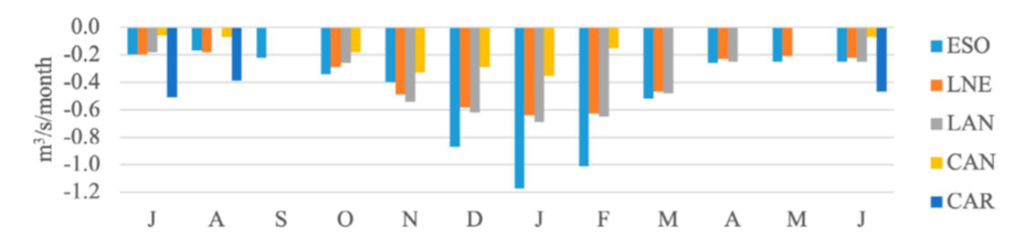
Trend tests indicate negative values for Puente El Sosneado, Loma Negra, and La Angostura in more than 96 % of their measurements. For Carmensa, there is an absence of trend in up to 72 % of its measurements, while Cañada Ancha shows a significant absence of trend in 48 % of its measurements.
It is important to emphasize the similarities among the stations, with maximum negative trends observed in summer (a period of higher evaporative and consumptive water demand from both natural processes and agricultural production) and minimum negative trends in the winter months (Figure 2). In any case, no significant positive trends were recorded for any variable or season.
Thumbnail
 Source: author's elaboration.
Figure 2
Kendall's significant monthly non-parametric linear trend values.
Kendall's significant monthly non-parametric linear trend values.
On the other hand, it is expected that the Carmensa station would exhibit a similar trend pattern to its upstream neighboring stations; however, it shows an absence of trends where the other stations register negative values (winter). This discrepancy may be due to the characteristics of the Atuel river at Carmensa, with drainage runoff from irrigated areas and remnants of upstream flows, indicating a higher level of anthropogenic impact in the basin.
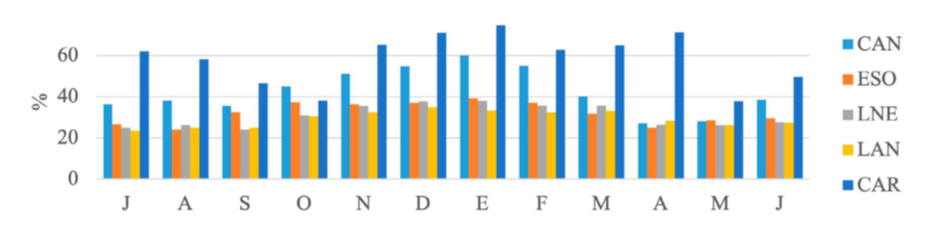
As shown in Figure 3, the annual differences range between 24 % and 74 %, remaining relatively constant across most of the stations except for Cañada Ancha and Carmensa. The latter exhibits the greatest differences between the two periods, ranging from 37.8 % to 74.6 %. For all seasons, the maximum values occurred in the December, January, and February quarter, while minimum values were observed during the winter months.
Thumbnail
 Source: author's elaboration.
Figure 3
Percentage decrease of the second period with respect to the first one in the years of the step change found (2007, 2008, 2009).
Percentage decrease of the second period with respect to the first one in the years of the step change found (2007, 2008, 2009).
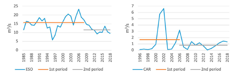
Regarding abrupt changes, the sequential Student’s t-test highlighted the main steps or abrupt changes in the series considered. Significant changes were found to be negative, indicating decreases in the means between the periods 1985-2008 and 2008-2019. The cutoff point was approximately in 2008; however, the period of change for all seasons and measurements occurred between 2007 and 2009.
Given that no dams were constructed in the area during this period, the observed step changes may be associated with climatic events. According to Mendoza’s Provincial Law No. 8318, the provincial government declared a water emergency due to expected low runoff for the 2010-2011 hydrological period, resulting from insufficient snowfall during the winter of 2010. This period also coincides with the beginning of the most recent phase of hydrological drought starting in 2009, linked to a negative El Niño Southern Oscillation (ENSO) event (Rivera, 2018).
-
Rivera, 2018La sequía provocada por “La Niña” en las montañas de Mendoza podría terminar, 2018
Figure 4 shows the percentage difference in step changes between the averages of the most recent block of years (2009-2019) and the previous block (1985-2008). For comparison, the stations Puente El Sosneado (ESO) and Carmensa were analyzed. The percentage of differences increases downstream, exceeding 70 % at Carmensa. This situation, primarily influenced by the onset of “La Niña” (negative ENSO), may have been exacerbated by anthropogenic activities, leading to reduced flows in the Atuel river as it passes through Carmensa and the irrigated oasis.
Thumbnail
 Source: author's elaboration.
Figure 4
Step changes for annual minimum flows in the gauge stations of the Atuel basin.
Step changes for annual minimum flows in the gauge stations of the Atuel basin.
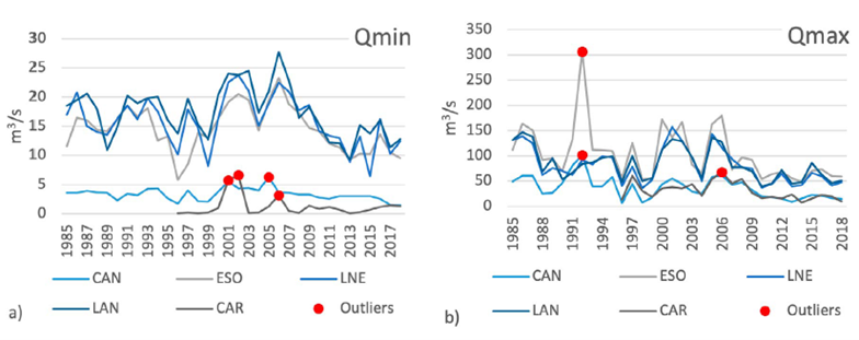
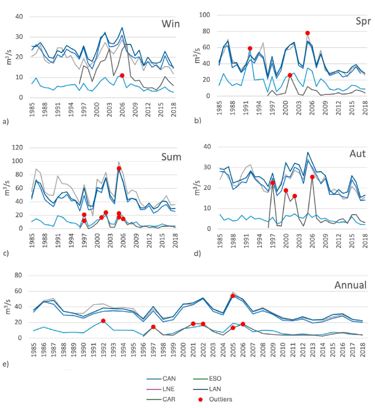
Regarding the results related to outliers, it is important to highlight that, since all stations are located within the same basin, the time series theoretically share similar characteristics concerning the magnitude and occurrence of extreme minimum and maximum events.
Thumbnail
 Source: author's elaboration.
Figure 5
Annual values out of range according to minimum (a) and maximum (b) flows.
Annual values out of range according to minimum (a) and maximum (b) flows.
Thumbnail
 Source: author's elaboration.
Figure 6
Annual values out of range by climatic stations - annual average and hydrometric station.
Annual values out of range by climatic stations - annual average and hydrometric station.
It should be noted that the tests used only detected outliers above the mean of the series, which are important for highlighting the hydrological response to external climatic events (such as ENSO). Outliers below the mean were not detected because there were no negative flow values. In this case, the identification of such outliers can be complemented by an analysis of hydrological droughts, where anomalies are more significant in terms of temporal and spatial references than in magnitude (for stations and values with zero flow records).
Analyzing outliers for ecosystems in the study area can be valuable, as they reveal the presence of periodic flood pulses, which are essential for maintaining healthy riparian and wetland environments. These flood pulses provide extraordinary water inputs that help control the salinization of such environments (Magnani, 2016), among other benefits.
-
Magnani, 2016Una visita a los desiertos del río Atuel, 2016
Although all the stations exhibited high outliers, their verification was performed by comparing all stations during the same reference periods. If one station presented an outlier, the others were expected to show either another outlier or, at a minimum, an increase in flows for the same period. Thus, there was no need to consult additional sources for verification or, in other cases, to exclude any data from the series.
Climatic and socio-economic context of the Atuel river basin
To better understand the above results, it is important to present the socio-natural context of the Atuel basin.
Regarding climatic characteristics, the basin's geographical position (intertropical zone and the southern hemisphere) on the slopes of the Andean mountain range and within the arid South American diagonal, means that the availability of water resources may be influenced by external events. These include the Föhn effect (in the rain shadow of the Andes), anticyclones, and humid winds from the Atlantic and Pacific Oceans (DGI, 2017).
-
DGI, 2017Aquabook, 2017
The Andean mountain range, as a natural barrier where Pacific winds deposit rain on the windward side, also acts as a retention and accumulation area for snow during the winter season. This snowmelt feeds the rivers with a permanent snowfall regime and represents a major source of groundwater recharge (Viale et al., 2019).
-
Viale et al., 2019Contrasting Climates at Both Sides of the Andes in Argentina and ChileFrontiers in Environ. Sci., 2019
As one of the main rivers in the region, the Atuel river's hydroelectric potential was recognized as early as the mid-1940s with the construction of dams. The Los Nihuiles complex, which serves multiple purposes (flood control, flow regulation, hydroelectric generation, and irrigation storage), consists of four dams with a combined storage capacity of nearly 431.7 hm³ (DGI, 2017).
-
DGI, 2017Aquabook, 2017
Regarding other anthropogenic factors and given the low rainfall, the economic potential of the basin is concentrated along the river axis, with greater emphasis downstream of the hydroelectric complex. In this area, agricultural activities are prominent (Southern Oasis), which, while shared with the neighboring Diamante river basin, are irrigated by the Atuel river over approximately 137,290 hectares. Table 3 presents the volumes and percentages of water allocated to various uses within the Atuel basin, according to the General Department of Irrigation (DGI, 2020), the provincial entity responsible for organizing and planning the use of water resources for agricultural purposes.
-
DGI, 2020Distribución estimada de agua superficial de los ríos. Temporada 19/20, ajustado a diciembre /19, 2020
Table 3
Estimated distribution of the surface water of the Atuel river Season 2019/2020.
Estimated distribution of the surface water of the Atuel river Season 2019/2020.
| Activity | Volume
|
Volume
|
| Total to be distributed | 415.4 | 100 |
| Water population supply | 5.3 | 1.3 |
| Agriculture | 406.4 | 97.8 |
| Industry | 0.3 | 0.1 |
| Mining and oil | 0.0 | 0.0 |
| Fracking | 0.0 | 0.0 |
| Recreational / environmental | 2.3 | 0.6 |
| Public use | 1.0 | 0.3 |
-
DGI (2020)Distribución estimada de agua superficial de los ríos. Temporada 19/20, ajustado a diciembre /19, 2020
The oases of Mendoza, such as those in the south (dominated by the Atuel and Diamante rivers), exemplify the local people's achievements in overcoming the region's natural desert conditions. These areas, situated on large alluvial deposits, have fertile soils, although their historical limitation has always been the lack of water for irrigation.
In 2019, the population of the Atuel basin was estimated at approximately 60,000 inhabitants (INDEC, 2020). This includes the populations of General Alvear (50,387 inhabitants, the capital of the homonymous department in the Province of Mendoza), Algarrobo de Águila (1,520 inhabitants, the capital of Chical Co department in the Province of La Pampa), and Santa Isabel (3,616 inhabitants, the capital of the Chalileo department in the Province of La Pampa).
-
INDEC, 2020Proyecciones 2010-2025 elaboradas en base a resultados del Censo Nacional de Población, Hogares y Viviendas 2010, 2020
Although the basin also extends into other departments of La Pampa province, such as Limay Mahuida and Puelín, and parts of Mendoza departments like San Rafael and Malargüe, it primarily encompasses the more populated areas of the departments. The rural population is significantly smaller than the urban areas indicated. Additionally, due to the concentration of population around the oases, the basin’s population is considerably smaller compared to the contiguous northern basin (Diamante river), which includes San Rafael, the largest and most dynamic city in southern Mendoza, with over 110,000 inhabitants.
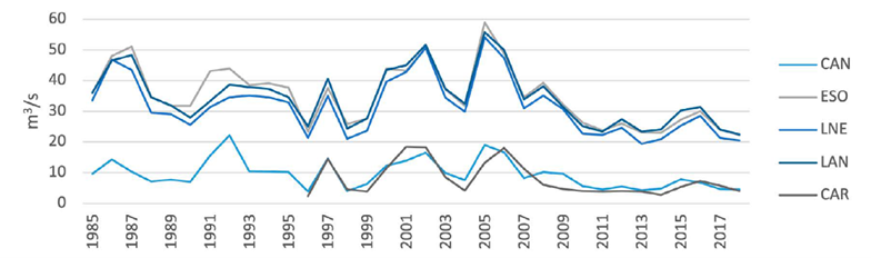
In this context and linking the above with the results from the normality, randomness, and independence tests, the basin exhibits a high level of water resource exploitation (evidenced by the absence of normality in 76 % of the measurements at the Carmensa station). This may suggest that most of the drained volume is utilized on the Mendoza side for the described purposes, leaving minimal or no runoff (Figure 7) for La Pampa (a situation resulting from the litigation).
Thumbnail
 Source: author's elaboration.
Figure 7
Annual runoff hydrograph for the stations under consideration.
Annual runoff hydrograph for the stations under consideration.
Furthermore, regarding randomness, human impacts on the basin are evident, with significant absences of this statistical characteristic in the months with higher irrigation demands. This is reinforced by the 92 % independence in measurements at Carmensa, indicating a disconnection from the natural river flows and a greater reliance on the remaining flows from upstream irrigated areas.
Figure 7 illustrates the differences in average annual flow between the upstream stations of the hydroelectric complexes (El Sosneado, Loma Negra, and La Angostura) and Carmensa, located downstream and near the end of the oasis.
The differences in runoff illustrate the decrease in flows from Mendoza to La Pampa. When considering additional natural demands such as evaporation and infiltration, these differences highlight the challenging reality faced by societies and ecosystems along the Atuel river in La Pampa territory for decades.
DISCUSSION
Results of Exploratory Data Analysis (EDA) are commonly used as preliminary tests to assess the statistical quality of data and to evaluate assumptions required for subsequent methodologies, such as normality, randomness, or independence (Hirsch et al., 1982). These methods provide a foundational approach to understanding hydrological variability and its drivers, particularly in basins where human intervention plays a significant role.
-
Hirsch et al., 1982Techniques of Trend Analysis for Monthly Water Quality dataWater Resources Research, 1982
Unlike previous research in the study area (Vich et al., 2013; Lauro et al., 2016; Lauro et al., 2018), which primarily describes the statistical conditions of the data series analyzed, this research aims to establish physical relationships (causality) based on the results (geographic principle of "relationship").
-
Vich et al., 2013Análisis regional de frecuencias de caudales de ríos pertenecientes a cuencas con nacientes en la cordillera de Los AndesMeteorologica, 2013
-
Lauro et al., 2016Variabilidad del régimen fluvial en cuencas de la región de CuyoGeoacta, 2016
-
Lauro et al., 2018Regional flood frequency analysis in the central‐western river basins of ArgentinaRiver Res Applic., 2018
The results from normality, randomness, and independence tests indicate anthropic intervention along the Mendoza axis of the Atuel river. While the river naturally exhibits irregular flow patterns typical of mountain systems, human activities contribute to significant hydrological alterations downstream, leading to increased randomness and independence of flows at the Carmensa station.
Given that the Carmensa station is the final gauge before the Atuel river enters the Pampean territory, the results suggest an altered state of the river upon entering the wetlands area, a situation contested by La Pampa in the lawsuit against Mendoza (Prieto, 1998; Rojas and Prieto, 2018; Barbosa, 2019; Rojas and Wagner, 2019).
-
Prieto, 1998Directora del Subproyecto Historia Ambiental en el marco del Estudio base cero Aprovechamiento Integral del Río Grande-Trasvase al Atuel, 1998
-
Barbosa, 2019Trayectoria del conflicto ambiental del río Atuel en la escala provincialBoletín de Estudios Geográficos, 2019
The quantitative results are consistent with previous studies in the area (Vich et al., 2013; Lauro et al., 2016; Lauro et al., 2018; López and Vich, 2018), showing significant normality, randomness, and independence in 70 %, 68 %, and 80 % of the measurements, respectively. Trend analysis indicates negative values like those found by the authors, except for the Carmensa station, which was not included in their studies.
-
Vich et al., 2013Análisis regional de frecuencias de caudales de ríos pertenecientes a cuencas con nacientes en la cordillera de Los AndesMeteorologica, 2013
-
Lauro et al., 2016Variabilidad del régimen fluvial en cuencas de la región de CuyoGeoacta, 2016
-
Lauro et al., 2018Regional flood frequency analysis in the central‐western river basins of ArgentinaRiver Res Applic., 2018
-
López and Vich, 2018Evaluación de deficiencia hídrica en ríos de Mendoza, 2018
In contrast, the findings related to abrupt changes differ from those as Lauro et al. (2016), as their methodologies’ position step changes based on the final date of the series considered. This research identifies significant abrupt changes consistent with a negative ENSO event in 2009 (Rivera, 2018).
-
Lauro et al. (2016)Variabilidad del régimen fluvial en cuencas de la región de CuyoGeoacta, 2016
-
Rivera, 2018La sequía provocada por “La Niña” en las montañas de Mendoza podría terminar, 2018
Finally, in agreement with Lauro et al. (2018), the maximum outliers in 1992 for El Sosneado and Cañada Ancha stations are highlighted (Figure 5b) as the highest peaks in all the time series analyzed. It is noteworthy that these outliers, along with others detected by the MAD-score, were corroborated among the stations analyzed, although not all peaks were classified as outliers.
-
Lauro et al. (2018)Regional flood frequency analysis in the central‐western river basins of ArgentinaRiver Res Applic., 2018
Unlike the methodologies used by the authors, MAD-score employs the monthly median measurements for each of the 12 months of the year, offering greater robustness to extreme events. This allows the detection of outliers where methods such as Rosner, WRC, or Grubbs may fail (Lauro et al., 2018). Notably, the atypical values related to summer floods in most seasons, particularly at Carmensa, with outliers in autumn (Figure 6d), reflect runoff from agricultural activities combined with years of water abundance in the region (Rivera, 2018).
-
Lauro et al., 2018Regional flood frequency analysis in the central‐western river basins of ArgentinaRiver Res Applic., 2018
-
Rivera, 2018La sequía provocada por “La Niña” en las montañas de Mendoza podría terminar, 2018
These findings contribute to the broader discourse on hydrological alterations in semi-arid and arid regions worldwide, where water scarcity exacerbates conflicts over resource allocation. In the case of the Atuel river, the interplay between water storage, consumption, and interprovincial governance adds another layer of complexity to hydrological and environmental management.
The hydrological alterations observed in the Atuel river are consistent with patterns reported in other semi-arid basins worldwide, like the Mendoza and San Juan rivers, which highlights how water management decisions in Andean basins, particularly through dam construction and irrigation, have led to the desiccation of wetlands and conflicts over resource allocation (Bastidas, 2023; Bastidas et al., 2024). Similar processes have been documented in the Colorado river (Christensen et al., 2004), where extensive damming and water diversion have significantly altered downstream hydrology, and in the Yangtze river, where the Three Gorges Dam has disrupted natural flow regimes and sediment transport (Zhang et al., 2016). In South America, the Paraná river basin has experienced hydrological alterations linked to hydroelectric development, leading to changes in flood dynamics and ecosystem connectivity (Agostinho et al., 2008).
-
Bastidas, 2023Caudal ambiental en el sitio Ramsar Lagunas de Guanacache, Desaguadero y del Bebedero, Argentina, 2023
-
Bastidas et al., 2024Los descendientes de los Huarpes y su nexo con los humedales áridos de Cuyo, ArgentinaRevista Notas Históricas y Geográficas, 2024
-
Christensen et al., 2004The Effects of Climate Change on the Hydrology and Water Resources of the Colorado River BasinClimatic Change, 2004
-
Zhang et al., 2016Impact of the Three Gorges Dam on the Hydrology and Ecology of the Yangtze RiverWater, 2016
-
Agostinho et al., 2008Dams and the fish fauna of the Neotropical region: impacts and management related to diversity and fisheriesBraz. J. Biol., 2008
While the methodology applied in this study is not entirely novel, its focus on establishing physical relationships and detecting abrupt changes in flow variability using a combination of statistical tests provides a more detailed understanding of the extent of human influence in the Atuel basin. This approach contributes to the broader discussion on water governance in semi-arid regions, where competing demands for water resources exacerbate environmental and socio-political tensions.
Future research should incorporate a multi-scalar approach that integrates hydroclimatic modeling with socioeconomic analyses to better understand the long-term implications of these alterations, which could provide valuable insights into mitigating the negative impacts observed in the Atuel river.
CONCLUSION
As the Atuel is one of the primary rivers in the region, both for its ecological importance in the arid zone and for the irrigation of oases, the human impacts on its flows are evident through exploratory approaches such as normality, randomness, and independence tests.
Exploratory analyses and the applied tests have verified the presence of anthropogenic impacts contributing to the river's hydrological alteration. This is evident from the similarities between the results of the upstream stations, located before the dam complex, and the Carmensa station, situated almost at the end of the Southern oasis and downstream of water usage. It can be inferred that water consumption and dam storage negatively affect the river's continuity and flow towards the Pampean territory.
Thus, human activities have a clear negative impact on river flows, facilitating the socioeconomic development of surrounding communities but with repercussions on downstream ecosystems and societies. The methodology used provides preliminary and exploratory evidence of the natural characteristics of the rivers, their hydrological conditions, and the human impacts on them.
The findings demonstrate that the region's aridity, combined with the natural characteristics of the rivers and human impacts on their hydrological regimes, creates a vulnerable situation for the ecosystems. This vulnerability has been evident for decades due to ongoing degradation.
Human presence in the territory alters the landscape and its resources, impacting both societies and natural spaces based on their location. Additionally, political-administrative differences (such as interprovincial boundaries) can be significant factors contributing to geographic alterations within the same basin.
In response to these differences, geography, as an integrative science of socio-natural elements in the territory, offers a diagnostic, analytical, and action-oriented approach to address problems, events, or phenomena in the regions.
Through its scientific branches (such as hydrography) and auxiliary sciences (such as statistics), exploratory analyses like the one conducted in this study enable the diagnosis of events along a river course such as the Atuel. The scope of current or future studies will depend on their relevance to the societies involved and the natural spaces affected (positively or negatively) in the human appropriation of the territory.
REFERENCES
- Adeloye, A., & Montaseri, M. (2002). Preliminary streamflow data analyses prior to water resources planning study. Journal of Hydrological Science, 47(5), 679-692. DOI: https://doi.org/10.1080/02626660209492973 Links
- Agostinho, A., Pelicice, F., & Gomes, L. (2008). Dams and the fish fauna of the Neotropical region: impacts and management related to diversity and fisheries. Braz. J. Biol. 68 (4 suppl). DOI: https://doi.org/10.1590/S1519-69842008000500019 Links
- Bae, I., & Ji, U. (2019). Outlier Detection and Smoothing Process for Water Level Data Measured by Ultrasonic Sensor in Stream Flows. Water, 11, 951. DOI: https://doi.org/10.3390/w11050951 Links
- Barbosa, L. (2019). Trayectoria del conflicto ambiental del río Atuel en la escala provincial. Boletín de Estudios Geográficos, (111), 95-119. Retrieved from https://revistas.uncu.edu.ar/ojs/index.php/beg/article/view/2492 Links
- Bastidas, L. (2023). Caudal ambiental en el sitio Ramsar Lagunas de Guanacache, Desaguadero y del Bebedero, Argentina. Tesis de Doctorado en Geografía. Universidad Nacional del Sur, Argentina. Retrieved from: https://repositoriodigital.uns.edu.ar/bitstream/handle/123456789/6415/BASTIDAS%20L.B._TESIS..pdf?sequence=1&isAllowed=y Links
- Bastidas, L., Piccolo, M., & Vich, A. (2024). Los descendientes de los Huarpes y su nexo con los humedales áridos de Cuyo, Argentina. Revista Notas Históricas y Geográficas, (33), 291-319. DOI: https://doi.org/10.58210/nhyg610 Links
- Bernal, J. (2012). Los principios del método geográfico. Retrieved from https://docplayer.es/20981393-Los-principios-del-metodo-geografico.html Links
- Buishand, T. (1982). Some methods for testing the homogeneity of rainfall records. J. Hydrology 58,11-17. DOI: https://doi.org/10.1016/0022-1694(82)90066-X Links
- Cazevane, H. (2015). La cuenca del río Desaguadero: un caso de desertificación por acción antrópica. Interespaço, revista de Geografía e Interdisciplinaridade, 1(2), 225-236. DOI: https://doi.org/10.18766/2446-6549/interespaco.v1n2p225-236 Links
- Christensen, N., Wood, A., & Voisin, N. (2004). The Effects of Climate Change on the Hydrology and Water Resources of the Colorado River Basin. Climatic Change, 62, 337-363. DOI: https://doi.org/10.1023/B:CLIM.0000013684.13621.1f Links
- Corte Suprema de Justicia de la Nación, CSJN. (2020). Fallo CSJ 243/2014 (50-L)/CS1, 16-07-2020. Retrieved from https://www.mendoza.gov.ar/prensa/wp-content/uploads/sites/5/2020/07/ADJ-0.341749001594918215.pdf Links
- Departamento General de Irrigación, DGI (2020). Distribución estimada de agua superficial de los ríos. Temporada 19/20, ajustado a diciembre /19. Retrieved from https://www.irrigacion.gov.ar/web/2020/02/05/estos-son-los-usos-del-agua-en-mendoza/ Links
- Departamento General de Irrigación, DGI. (2017). Aquabook. Software de información hídrica didáctica asociada al Departamento General de Irrigación. Retrieved from https://aquabook.agua.gob.ar/ Links
- Döll, P., & Zhang, J. (2010). Impact of climate change on freshwater ecosystems: a global-scale analysis of ecologically relevant river flow alterations. European Geosciences Union, 14(5). DOI: https://doi.org/10.5194/hess-14-783-2010 Links
- Falaschi, D., Lenzano, M., Tadono, T., Vich, A., & Lenzano, L. (2018). Balance de masa geodésico 2000-2011 de los glaciares de la cuenca del río Atuel, Andes Centrales de Mendoza (Argentina). Geoacta, 42(2), 7-22. Retrieved from https://ppct.caicyt.gov.ar/index.php/geoacta/article/download/11869/45454575757723 Links
- Gyau-Boakye, P. (1993). Filling gaps in hydrological runoff data series in West Africa. (PhD thesis). Ruhr-University Bochum, Germany. Links
- Gyau-boakye, P., & Schultz, G. (1994). Filling gaps in runoff time series in West Africa. Hydrological Sciences Journal, 39(6), 621-636. DOI: https://doi.org/10.1080/02626669409492784 Links
- Hirsch, R., Snack, J., & Smith, R. (1982). Techniques of Trend Analysis for Monthly Water Quality data. Water Resources Research, 18(1), 107-121. DOI: https://doi.org/10.1029/WR018i001p00107 Links
- Instituto Nacional de Estadística y Censos INDEC. (2020). Proyecciones 2010-2025 elaboradas en base a resultados del Censo Nacional de Población, Hogares y Viviendas 2010. Retrieved from https://sitioanterior.indec.gob.ar/nivel4_default.asp?id_tema_1=2&id_tema_2=24&id_tema_3=119 Links
- Interagency Advisory Committee on Water Data. (1982). Guidelines for Determining Flood Flow Frequency, Bulletin 17 B. U.S. Department of Interior, Geological Survey. Office of Water Data Coordination. Retrieved from https://water.usgs.gov/osw/bulletin17b/dl_flow.pdf Links
- Kundzewicz, Z., & Robson, A. (2000). Detecting Trend and Other Changes in Hydrological Data. World Climate Program Data and Monitoring. WMO/TD-No. 1013. Retrieved from https://library.wmo.int/doc_num.php?explnum_id=4183 Links
- Lauro, C., Vich, A., & Moreiras, S. (2016). Variabilidad del régimen fluvial en cuencas de la región de Cuyo. Geoacta, 40(2), 28-51. Retrieved from http://ppct.caicyt.gov.ar/index.php/geoacta/article/view/5385/7202 Links
- Lauro, C., Vich, A., & Moreiras, S. (2018). Regional flood frequency analysis in the central‐western river basins of Argentina. River Res Applic., 34(7), 1-13. DOI: https://doi.org/10.1002/rra.3319 Links
- Leys, C., Ley, C,. Klein, O., Bernard, P., & Licata, L. (2013). Detecting outliers: Do not use standard deviation around the mean, use absolute deviation around the median. Journal of Experimental Social Psychology 49, 764-766. DOI: https://doi.org/10.1016/j.jesp.2013.03.013 Links
- López, P., & Vich, A. (2018). Evaluación de deficiencia hídrica en ríos de Mendoza. XXVIII Congreso Latinoamericano de Hidráulica, Buenos Aires, Argentina, septiembre de 2018. Links
- Magnani, R. (2016). Una visita a los desiertos del río Atuel. Fundación Chadileuvú. Retrieved from http://www.chadileuvu.org.ar/fuchad/index.php/justicia-por-el-atuel/actualidad/153-una-visita-a-los-desiertos-del-rio-atuel Links
- Mann, H., & Whitney, D. (1947). On a Test of Whether one of Two Random Variables is Stochastically Larger than the Other. The Annals of Mathematical Statistics, 18(1), 50-60. DOI: https://doi.org/10.1214/aoms/1177730491 Links
- Miller, J. (1991). Reaction time analysis with outlier exclusion: Bias varies with sample size. The Quarterly Journal of Experimental Psychology, 43(4), 907-912. DOI: https://doi.org/10.1080/14640749108400962 Links
- Nilsson, C., Reidy, C., Dyneius, M., & Revenga, C. (2005). Fragmentation and Flow Regulation of the World's Large River Systems. Science, 308(5720), 405-208. DOI: https://doi.org/10.1126/science.1107887 Links
- Organización Meteorológica Mundial, OMM. (2011). Guía de prácticas hidrológicas. Volumen II. OMM-Nº 168 (6ª ed.). Retrieved from http://www.wmo.int/pages/prog/hwrp/publications/guide/spanish/168_Vol_II_es.pdf Links
- Pettitt, A. (1979). A nonparametric approach to the change-point problem. Applied Statistics, 28, 126-135. DOI: https://doi.org/10.1080/10.2307/2346729 Links
- Poff, N., Zimmerman, J. (2009). Ecological responses to altered flow regimes: a literature review to inform the science and management of environmental flows. Freswater Biology, 55(1), DOI: https://doi.org/10.1111/j.1365-2427.2009.02272.x Links
- Prieto, M. (1998). Directora del Subproyecto Historia Ambiental en el marco del Estudio base cero Aprovechamiento Integral del Río Grande-Trasvase al Atuel. Res 1721/98, Ministerio de Ambiente y Obras Públicas. Convenio CONICET-MAYOP-FUNC. CRICYT Links
- Remington, R., & Schork, M. (1974). Estadística Biométrica y Sanitaria. Prentice Hall Internacional. Links
- Richter, B., Mathews, R., Harrison, D. & Wigington, R. (2003). Ecologically sustainable water management: managing river flows for ecological integrity. Ecological Applications. Ecological Society of America, 13(1), 206-224. DOI: https://doi.org/10.1890/1051-0761(2003)013[0206:ESWMMR]2.0.CO;2 Links
- Rivera, J. (2018). La sequía provocada por “La Niña” en las montañas de Mendoza podría terminar. Retrieved September 27th, 2018, from Retrieved September 27th, 2018, from https://www.conicet.gov.ar/cientificos-advierten-que-la-sequia-provocada-por-la-nina-en-las-montanas-de-mendoza-podria-terminar/ Links
- Rojas, F., & Prieto, M. (2020). La variabilidad hídrica en la cuenca del río Atuel, desde la climatología histórica: siglo xviii a mediados del xx. Cuadernos de Geografía: Revista Colombiana de Geografía, 29(2), 326-353. DOI: https://doi.org/10.1080/10.15446/rcdg.v29n2.75960 Links
- Rojas, F., & Wagner, L. (2016). Conflicto por la apropiación del río Atuel entre Mendoza y La Pampa (Argentina). HALAC, VI(2), 278-297. Retrieved from https://halacsolcha.org/index.php/halac/article/view/252/247 Links
- Salas, J. (1992). Analysis and modelling of hydrologic time series. Handbook of Hydrology. MacGraw-Hill. Links
- Sarafian, P. (2006). Cuenca Del Atuel. Retrieved from http://www.hidricosargenti-na.gov.ar/59.pdf Links
- Schmidt, J., Webb, R., Valdez, R., Marzolf, R. & Stevens, L. (1998). Science and Values in River Restoration in the Grand Canyon: There is no restoration or rehabilitation strategy that will improve the status of every riverine resource. BioScience, 48(9), 735-747. DOI: https://doi.org/10.2307/1313336 Links
- Secretaría de Infraestructura y Política Hídrica de la Nación, SIPHN. (2019). Base de datos hidrológica integrada. Ministerio del Interior, Obras Públicas y Vivienda. República Argentina. Retrieved from https://snih.hidricosargentina.gob.ar/Filtros.aspx# Links
- Viale, M., Bianchi, E., Cara, L., Ruiz, L., Villalba, R., Pitte, P., Masiokas, M., Rivera, J., & Zalazar, L. (2019). Contrasting Climates at Both Sides of the Andes in Argentina and Chile. Frontiers in Environ. Sci., 7, 550-569. DOI: https://doi.org/10.3389/fenvs.2019.00069 Links
- Vich, A., Norte, F., & Lauro, C. (2013). Análisis regional de frecuencias de caudales de ríos pertenecientes a cuencas con nacientes en la cordillera de Los Andes. Meteorologica, 39(1,), 3-26. Retrieved from http://www.scielo.org.ar/pdf/meteoro/v39n1/v39n1a01.pdf Links
- Westmacott, J., & Burn, D. (1997). Climate change effects on the hydrologic regime within the Churchill-Nelson river Basin. Journal of Hydrology, 202, 263-279. Links
- Worsley, K. (1979). On the likelihood ratio test for a shift in location of normal populations. J. Am. Statistic As. 74, 365-367. DOI: https://doi.org/10.2307/2286336 Links
- Zhang, X., Dong, Z., Gupta, H., Wu, G., & Li, D. (2016). Impact of the Three Gorges Dam on the Hydrology and Ecology of the Yangtze River. Water, 8(12), 590. DOI: https://doi.org/10.3390/w8120590 Links