


 nueva página del texto (beta)
 Inglés (pdf)
 Artículo en XML
 Referencias del artículo
 Enviar artículo por email
 Citado por SciELO
  Similares en
SciELO
Similares en
SciELO 
 Permalink
1. Introduction
During the last four decades, several volcanic eruptions, many with tragic consequences, have increased awareness of the risks posed to human life and its activities by active volcanoes. Monitoring and studying the eruptive history of volcanoes likely to enter into an active state is essential to lessen these events' impact. In many countries, the presence of several volcanoes and limited resources for their study requires the prioritization of the volcanoes to consider. The criteria for selecting such structures are based on their previous eruptive history and the hazards they pose. Concerning the latter, the volcanoes in areas with significant population and activity in historical times should be of primary interest.
In the case of Mexico, it is generally agreed that about a dozen volcanoes can be cataloged as hazardous, as they have erupted in historical or geologically recent times. Due to a significant surrounding population, most of those posing the highest risk are monitored by a minimum of seismic stations. In addition, almost all of these volcanoes are of andesitic composition, and it would be expected that a period of premonitory activity would announce an impending eruption. Nevertheless, not all eruptions are preceded by a suitable period of premonitory events, as demonstrated by the 2002 eruption of the Reventador volcano in Ecuador, which caused substantial social and economic damage to the country (Hall et al., 2004). This situation is even more likely in basaltic volcanoes because, as stated by Houghton et al. (2004), "the rapid ascent rates of basaltic magma means that the warning time between the onset of unrest and eruption may be as short as a few hours." In agreement with the above, Cassidy et al. (2019) found, from petrologic studies of eruption products from Kelud volcano in Indonesia, that in the explosive eruptions of this volcano, magma ascended in a matter of minutes to hours, even when sourced from deep reservoirs. That is precisely the case of San Martin Tuxtla volcano (SMTV, -95° 11.905', 18° 33.692', 1661 masl.), rising amid the Los Tuxtlas volcanic field (LTVF) in the lowlands of eastern Mexico and western margin of the Gulf of Mexico (Figure 1). The SMTV is one of its largest volcanoes in the LTVF a monogenetic volcanic field of basaltic, mostly alkaline, composition.
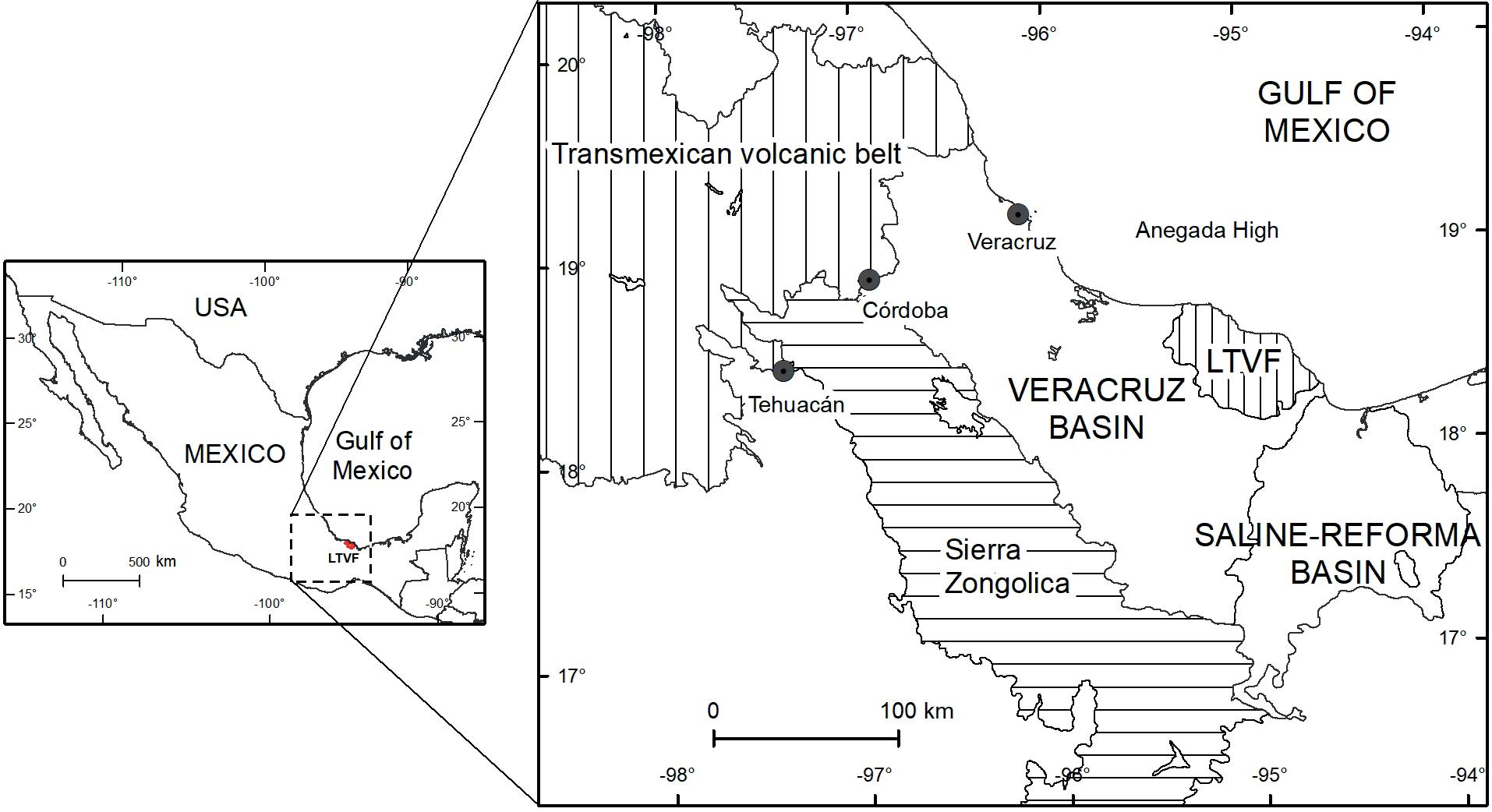
Figure 1 Location of the Veracruz Basin and the Los Tuxtlas Volcanic Field (modified after Prost and Aranda, 2001).
SMTV underwent its historical eruptions in 1664 and 1793. The latter's eruptive period lasted for several months, in which four main strong Strombolian phases, producing columns more than 10 km high, caused a widespread cover of ash. No human lives were lost during the eruptive period; however, because they began without any perceived premonitory activity, it surprised the surrounding population, causing general anxiety and hampering people's activities and livelihood. The explosive events were followed by almost a year of slow effusive activity that produced a long lava flow on the volcano's northern slope (Garcia, 1835). An eruption of similar intensity nowadays would certainly cause significantly more damage, as now there is a larger population dedicated mainly to agricultural, agro-industrial, cattle raising, and touristic activities; despite this, no entities are currently monitoring this volcano. Thus, it is evident that SMTV should be subjected to at least basic monitoring.
Nowadays, seismicity detection constitutes the backbone of most volcano monitoring systems. However, because the level of activity varies among active volcanoes, the interpretation of the seismicity is based on the changes in its pattern and the characteristics of the signals recorded. Therefore, knowledge of the background seismicity is fundamental to account for such changes, yet no such data is available for the SMTV.
Accordingly, to obtain information on the present level of seismicity, we deployed a set of stations around SMTV for about four years. We located the foci of the recorded events and obtained the focal mechanisms of some of them. Even though from such a small array, these results constitute helpful background information that provides basic background information about the seismicity associated with SMTV and offers guidelines for setting up a permanent network of monitoring seismic stations.
2. Geology and Tectonics of the San Martin Volcano Area
SMTV, as mentioned, is one of the largest volcanoes in the LTVF, also referred to as Los Tuxtlas Massif, and its presence is related to the history of this volcanic field. The first studies on the geology of the LTVF and SMTV volcano were carried out by Friedlaender and Sonder (1923). Further studies on the geochemistry of its rocks were published later by Pichler and Weyl (1976) and Thorpe (1977). Nelson and González-Caver (1992) and Nelson et al. (1995) carried out an ample study on the geochemistry and chronology of the rocks of the volcanic field and found a predominance of rocks of alkaline composition. From the age of the rocks, they concluded that the activity occurred in two periods separated by a pause of inactivity. Thus, they divided the volcanic field into the older and younger volcanic series (OVS and YVS, respectively). The rocks from the OVS have ages from 7 to 2.6 Ma and underlie the YVS. They crop out at the SE and W portions of the LTVF and include the large volcanoes of Santa Marta, San Martín Pajapan, and Cerro el Vigía. The rocks from the YVS were extruded from 0.8 Ma to the present and include San Martín volcano and a large number of scoria cones and maars (Reinhardt, 1991; Figure 2).
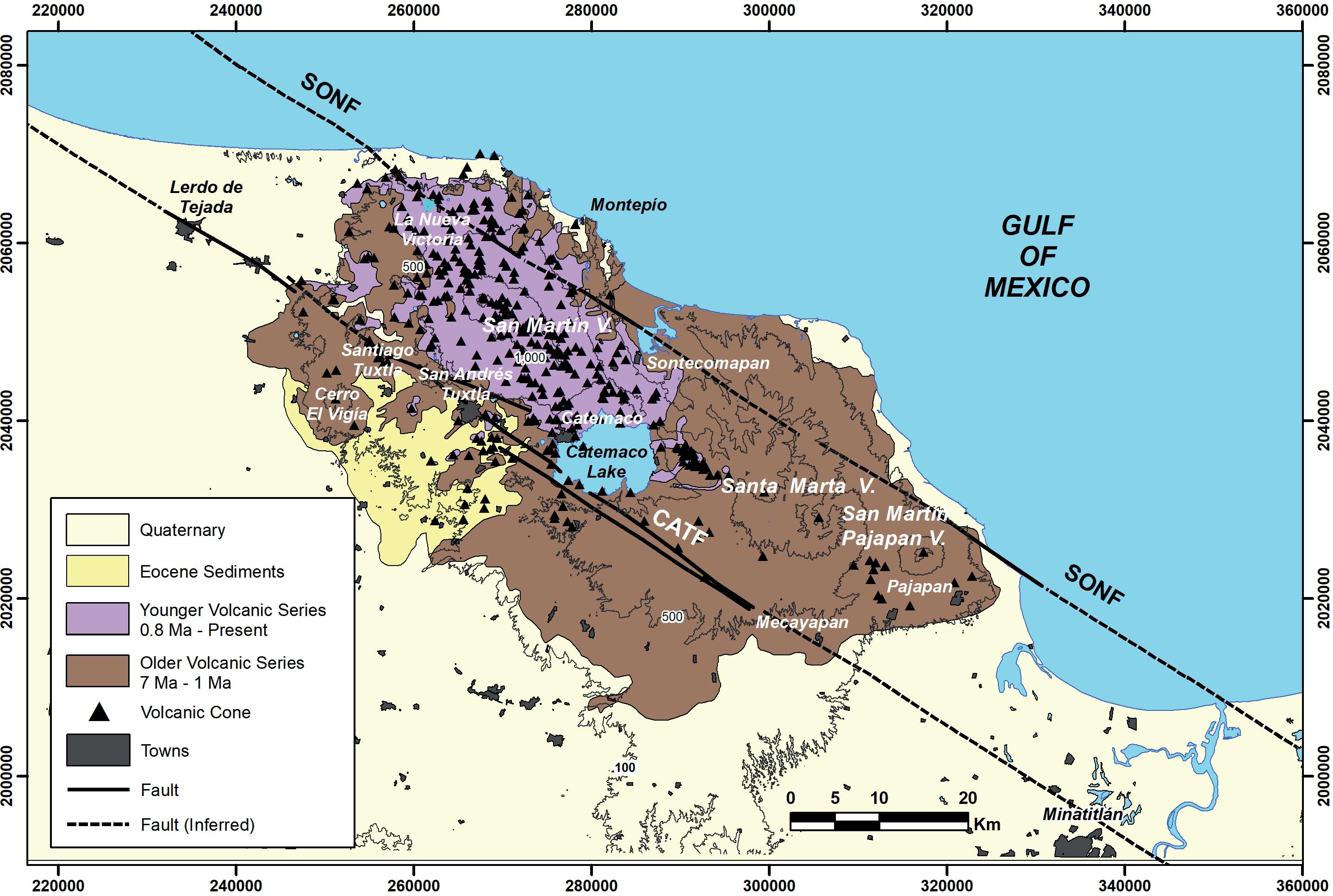
Figure 2 General view of the geology of the Tuxtlas Volcanic Field. SONF: Sontecomapan Fault. CATF: Catemaco Fault (modified after Espindola et al., 2016)
The LTVF is about 350 km from the Pacific Trench and some 110 km from the Mexican Volcanic Belt. The crust under the LTVF is about 30 km thick, with an interphase at about 12 km (Zamora-Camacho et al., 2010). There is no well-constrained position of the subducting Cocos slab under the LTVF, but an extrapolation of its bottom obtained from Receiver Functions places it beyond a depth of 100 km (Espíndola et al., 2017). Because of the distance to the Mexican Volcanic Belt and the particular composition of its rocks, there is no wholly agreed explanation of its origin. However, it shows affinity with rocks from a belt of alkaline mafic volcanic fields outcropping along the eastern margin of Mexico, forming the so-called Eastern Alkaline Province (Robin, 1976, 1982). Nevertheless, most researchers consider its origin as related to the subduction of the Cocos plate under the North American plate as some of its rocks are of calc-alkaline composition (e.g., Nelson et al., 1995).
Tectonically, the LTVF is part of the Veracruz Basin, a structure bounded to the north by the Trans-Mexican Volcanic Belt, to the west by the Sierra Zongolica fold-thrust belt, to the south by the Saline-Reforma Basin, and to the west by the Anegada high in the Gulf of México (Prost and Aranda, 2001, Figure 1). The TVF field spans an area of approximately 5000 km2. It is composed of four large volcanic edifices, Cerro El Vigía, San Martin Tuxtla, Sierra Santa Marta (composed of Santa Marta and Yohualtapan volcanoes), and San Martin Pajapan, along with about 353 distinct basaltic cones and some 42 maars. Andreani et al. (2008) have proposed that the two major NW-SE strike-slip faults identified in the Veracruz basin and the LTVF are connected at depth, forming a sizeable transpressive flower structure named the Veracruz fault. Thus, the fault system comprises the Sontecomapan and Catemaco faults and the Tres Zapotes fault zone. According to these authors, left-lateral transpressive deformation was initiated during the mid-Miocene and continues to the present. The traces of the faults are revealed in the LTVF by the principal alignment of volcanic cones; in particular, the Sontecomapan fault is inferred under the San Martin volcano area (Figure 2).
No intense seismicity occurs in the LTVF; however, from 1959 to 2021, nine events of moderate magnitude (4.8<Mw<6.4) have occurred to the NW and SE of the volcanic field and have been reviewed recently by Iglesias et al. (2024).
The LTVF is characterized by large positive gravity and geomagnetic anomalies that cover the whole volcanic field; however, the main volcanic edifices are not associated with particular positive or negative highs that can be identified as magma chambers. This indicates that, as in most monogenetic volcanic areas, they have been fed by a complex system of dikes, as have the rest of the monogenetic cones and maars (Espíndola et al., 2016).
3. The 1793 Eruption of San Martin Tuxtla Volcano
Details of the 1793 eruption of SMTV were given by Moziño (1870) and reviewed by Espindola et al. (2010; 2012); hereafter, we summarize its main characteristics.
In early March 1793, the San Martin Tuxtla volcano, located some 15 km from the town of Tuxtla (now Santiago Tuxtla), began a period of explosive activity that would last about eight months, causing general anxiety to the inhabitants of the surrounding towns. News of those events reached Count of Revillagigedo, Viceroy of the New Spain in Mexico City, who entrusted Don José Mariano Moziño, a naturalist from Mexico City, with investigating the events and reporting his observations. The naturalist arrived in the area on September 1793 and began his task by gathering the details of the activity from the area residents.
The report he wrote to the viceroy gives an account of his observations and inquiries among the region's inhabitants. Copies of his account were sent to Spain and are preserved in the Archives of the Indies (Archivo de Indias) in Seville, Spain. The report, almost verbatim, was published in Mexico by the Sociedad Mexicana de Geografía y Estadística in its Bulletin (Moziño, 1870). Here we present a translation of the account given by Moziño of the beginning of the eruption to emphasize the lack of premonitory activity:
"On March 2 of the present year [1793], at four o'clock in the afternoon in all villages, great blasts coming from the said mountain [San Martin Tuxtla volcano] were heard, which, despite arising from the underground, everybody mistook as coming from a thunderstorm, very frequent in the mountains. A heavy cloud cover surrounded the summit of the mountains so that a raging storm seemed to be approaching. At six o'clock, a large column of fire was observed towards the northeast of Tuxtla and the north of San Andres; many thunderbolts stemming from its center and swerving in different directions, frightening the eyewitnesses and rushing the crowds to their churches, imploring for divine mercy thinking that, if not the ruin of the universe, at least of the region was inevitable."
Although Moziño, who arrived in the area in early September of that year, did not witness this event, all the inhabitants of the surrounding villages experienced it, and it would be unlikely that they had omitted to mention the occurrence of earthquakes announcing the impending eruption. The same unexpected situation occurred before the following eruptive periods, on 22 May, 28 June, and 26 August 1793.
Although no felt earthquakes were reported preceding every eruptive phase, even the more explosive, it is reasonable to expect that some preceding seismicity could have been detected with modern instruments. During his inquiries in Los Tuxtlas, Moziño was told by the village elders a narrative passed down from their ancestors of a previous explosive eruption occurring in 1664, which was confirmed by José Aurelio Garcia (1835), who reported having read documents from the archives of the town of Santiago Tuxtla describing aspects of the eruption. It seems that this last eruption had similar characteristics in its abruptness, also causing intense panic among the population. Details of the 1793 eruption, such as the extent of the deposition of ashes in the area and the elevation of the eruptive cloud, have been considered by Espindola et al. (2007) and Espindola et al. (2012).
4. Data and Methods
To register the seismic activity close to the SMTV, we deployed three broadband Guralp CMG 6TD instruments from 2007 to 2013 (Figures 3 and 4, Table 1). These stations operated continuously, albeit with some vicissitudes, such as the substitution of station RATU for station SITU after the former was vandalized. The instruments operated with solar panels, storing the information in internal memories, which were downloaded periodically. Given the memory's relatively small capacity, the site's remoteness, and limited resources, the instruments were set to record continuously at 20 sps. This set of stations will hereafter be referred to as Los Tuxtlas Network (LTN).
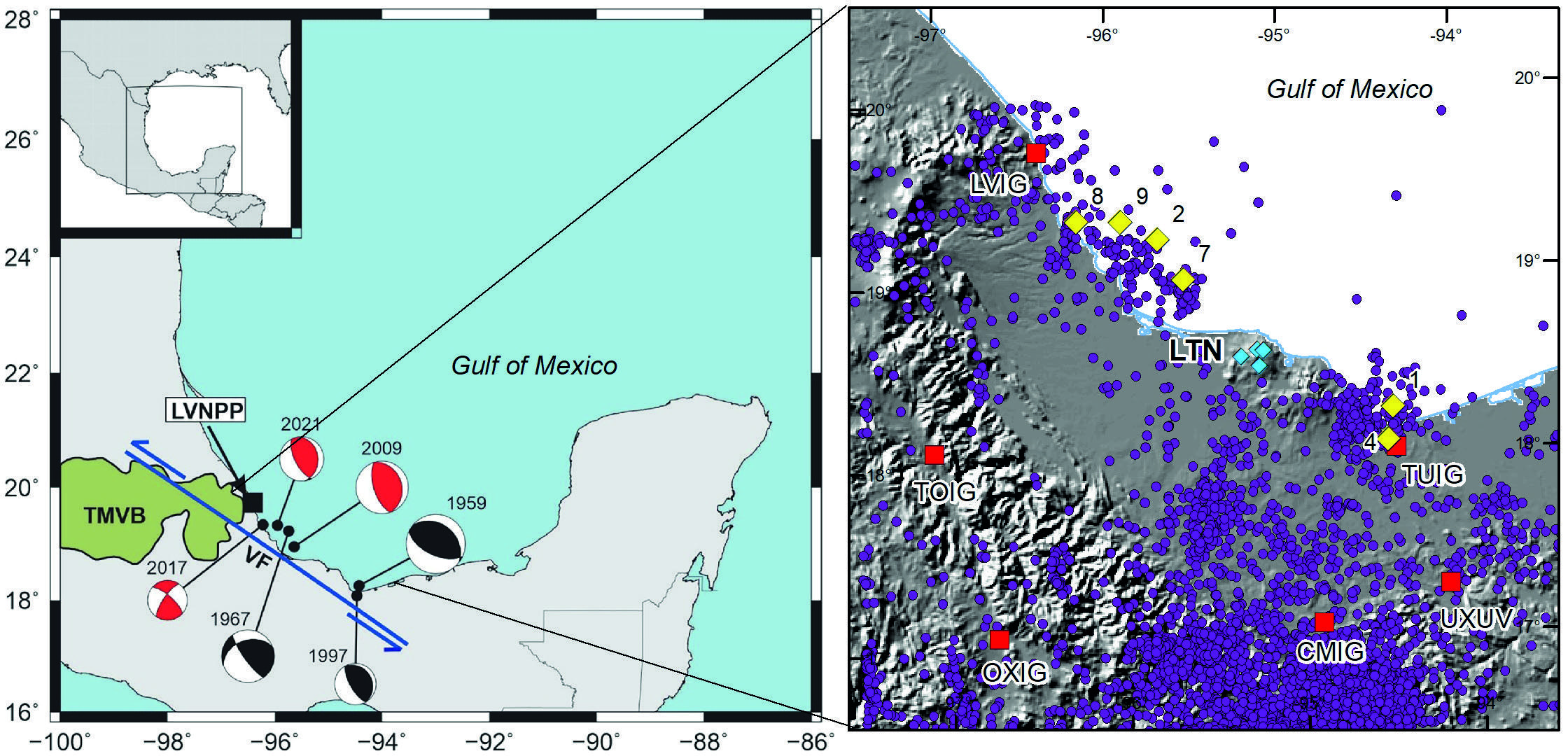
Figure 3 Left: Location and focal mechanism of six moderate earthquakes with foci near the LTVF (Yellow diamonds. Modified after Iglesias et al. (2024). Right: Seismic stations (red squares) close to the Tuxtla Volcanic Field. SSN Stations: LVIG, TUIG, TOIG, OXIG, CMIG. Station UXUV, from Universidad Veracruzana, shares its signals with SSN. Purple dots: Epicenters of events less than 40 km deep registered from 2000 to 2023. LTN: Stations of the Los Tuxtlas Network (Blue diamonds).
Table 1 Seismic Stations of the Los Tuxtla network (LTN).
| Name of station | Latitude | Longitude | Elevation (masl) | Sensor type | Start of recording | End of recording |
|---|---|---|---|---|---|---|
| RATU | 18.597 | -95.195 | 845 | Guralp 6TD | 7 March 2007 | 11 April 2011 |
| CHITU | 18.509 | -95.184 | 853 | Guralp 6TD | 8 March 2007 | 30 September 2013 |
| SITU | 18.565 | -95.286 | 772 | Guralp 6TD | 4 March 2009 | 28 September 2013 |
| MIHTU | 18.594° | -95.159° | 784 | Guralp 6TD | 5 May 2012 | 30 September 2013 |
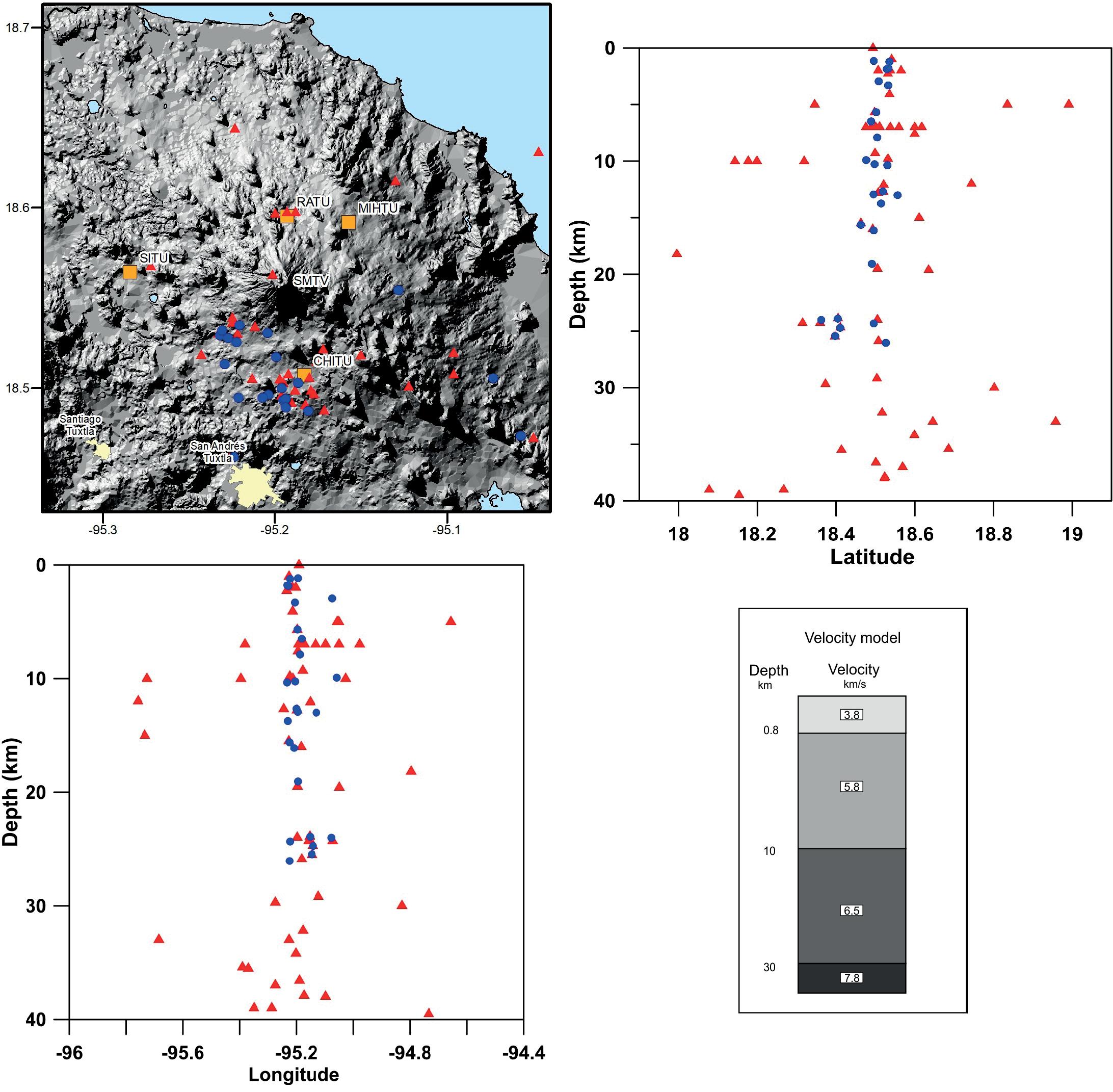
Figure 4 Hypocenters of the microearthquakes located with the LTN recordings and the velocity model shown at the bottom right (red triangles). The events relocated using the DD method are shown in blue circles. LTN Stations (orange squares): RATU, CHITU, SITU, MIHTU (see Supplementary Material for additional data).
The seismic events recorded in the LTN instruments were selected from the background noise and the P and S phase arrival times and coda lengths, determined on-screen and processed to obtain hypocenters with the software SEISAN (Ottemöller et al., 2013); which uses mostly Geiger’s and Galitzin´s methods for this purpose. The velocity model used to locate the events recorded was determined considering the receiver function analysis of Zamora et al. (2010); according to this, the Moho in the TVF region is found at depths between 28 and 34 km, with an intracrustal interface at a depth between 10 and 14 km. Such interface corresponds to the contact between the transitional crystalline crust at the base and a sedimentary layer present around the Gulf of Mexico. The zero level for the seismic stations was set at 800 masl, the average altitude at which they were deployed; thus, we considered a superficial layer of that thickness corresponding mainly to the rocks of the LTVF. We ran several tests varying the thickness of the layers between those stated above and found the smallest overall RMS with a crust of three layers with the velocities shown in Figure 4).
The magnitude of the events was computed from the formula used regularly by the SSN:
With the records from the LTN stations, we were able to relocate a group of events through the Double Difference technique of Waldhauser and Ellsworth (2000) (implemented in SEISAN). Not all events recorded were relocated, as the technique requires certain characteristics that depend, among other things, on the number of recording stations. Thus we were able to relocate 30 of the events recorded.
Because the small number of stations precluded the use of polarity of body waves to obtain focal mechanisms, we used the method of Singh et al. (2000) for this purpose. This technique requires fitting clear S phases to a theoretical S phase, which requires clear and ample waveforms to be used. This fact limits the number of events to be used and does not necessarily include those relocated with the double difference method. We used the polarity of the P-phase as a weak confirmation of the mechanism. Appendix C in the supplementary material shows the fittings and focal mechanisms obtained.
5. Results and Discussion
As background information on the seismicity at the LTVF and surrounding areas, we resorted to the SSN catalog of events for the period 2000-2023. We chose the events of this catalog with hypocenters up to 40 km to exclude events occurring below the crust since those are related to processes not directly related to the processes below SMTV. The epicenters appear in Figure 3 and are of small magnitude (1.9 < Mc < 5.5). The larger earthquakes studied by Iglesias et al. (2024) occur on the periphery of the volcanic field and are shown in the same figure.
Notice the relative scarcity of epicenters with a magnitude greater than 1.9 in the LTVF in 23 years. This feature cannot be explained by the location of the SSN stations since some stations to the west of the LTVF register events taking place on its eastern side. However, the LTN stations installed inside the volcanic field, close to the SMTV, recorded 60 microseisms occurring within the area (Figure 3).
The coda magnitudes of these events, determined with an RMS <0.8, fall in the interval 0.2<Mc<2.4 (see Appendix A in the Supplementary Material). Most of these events are not recorded by the stations of the SSN and had epicenters clustered in the proximity and to the south of the SMTV, with hypocenters above the 40 km depth.
To attain a more reliable assessment of the location of the hypocenters, we relocated the events using the DD method. Due to the requirements of this method, only 30 could be relocated and are also plotted in Figure 4. The epicenters of these events are relocated at about the same zone as the original locations; that is, they are clustered along the NW-SE direction that follows San Martin Volcano and the cinder cones on its SW side (see Appendix B in the Supplementary Material). The Sontecomapan and Catemaco Faults bound this area to the north and south respectively.
For nine of the above events with a clear S phase, we were able to obtain the focal mechanisms. The fittings of the S phases are shown in the Appendix C in the Supplementary Material, and the focal mechanisms in Figure 5.
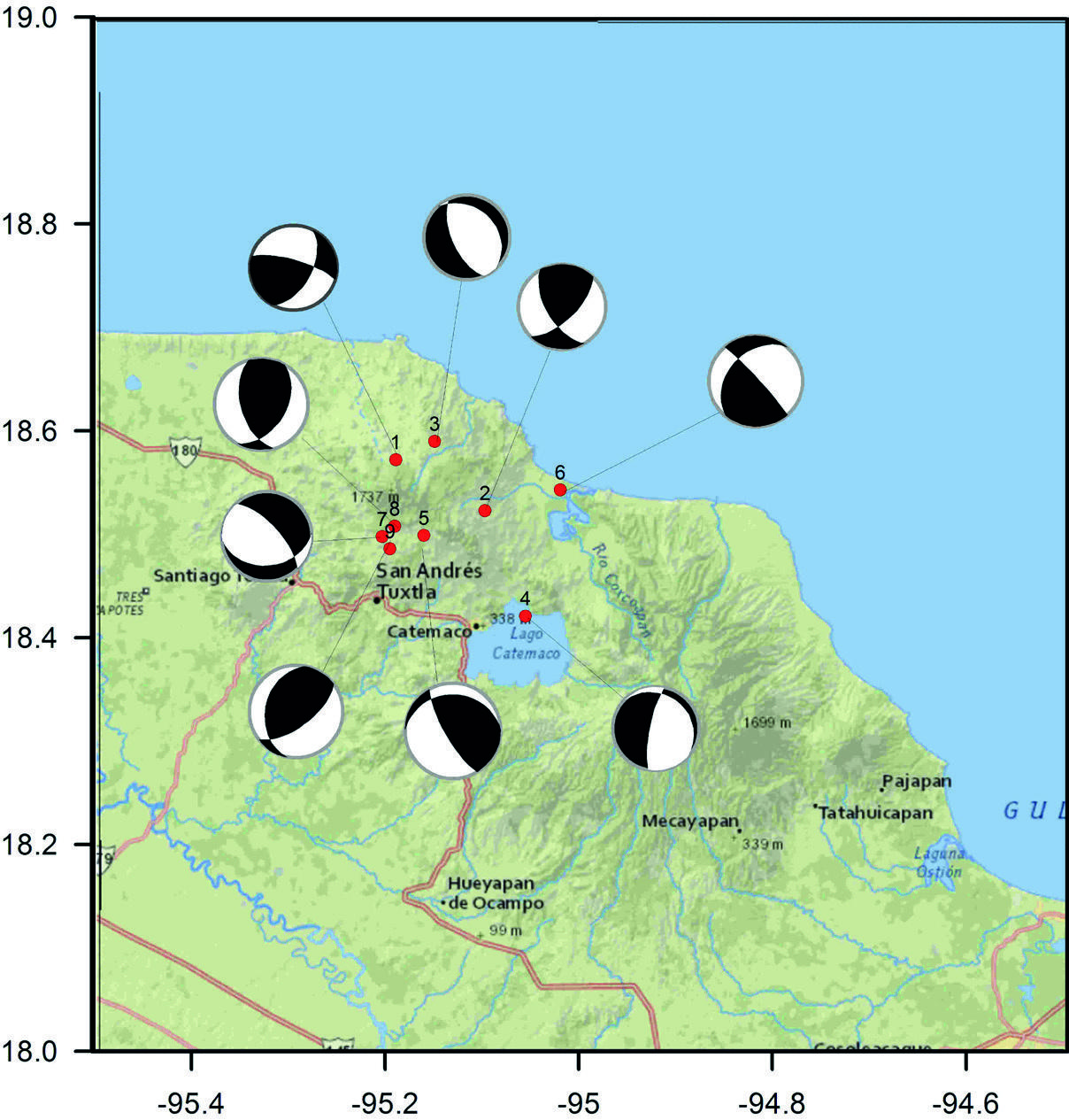
Figure 5 Focal Mechanism of nine events determined with S-wave fitting to signals from the LTN (Stations SITU, RATU, MITU, CHITU).
To have an overall view of all the focal mechanisms in the area, they are also plotted in a ternary diagram following the method of Frolich (1992).
Frolich's method consists of plotting in a ternary diagram the pressure (P), tension (T), and null axes (B) derived from the focal mechanisms as follows:
The dip angle with respect to the horizontal of the pressure (
Thus, the focal mechanism of a given event can be plotted uniquely in a ternary diagram with the following parameters:
Such a diagram for the events of Figure 5, together with the earthquakes analyzed by Iglesias et al. (2024), is displayed in Figure 6. The ternary diagram is divided into zones with the terminology used by Khalil and Al-Arifi (2019).
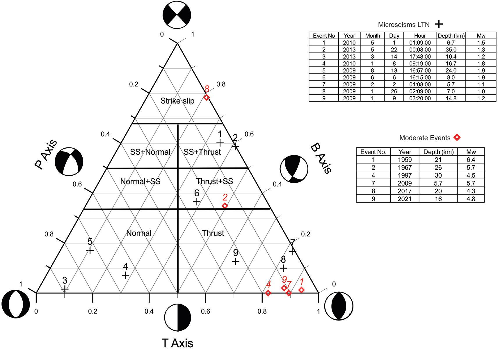
Figure 6 Ternary diagram for the focal mechanisms of moderate events (Iglesias et al., 2024) and those obtained with the events registered by the LVF, (Terminology of the mechanism zones after Khalil and Al-Arifi, 2019).
The diagram shows that the larger earthquakes associated with the regional stresses have different azimuths and some strike-slip components but are mainly of the inverse type, suggesting that the regional stress is compressional. In turn, most of the focal mechanisms of the microearthquakes fall in the same field of events with significant inverse components. Zhan et al. (2022) analyzed the focal mechanism of the events associated with the 2006 activity of Augustine volcano, Alaska, and found that they show the effect of the regional tectonic stress, the volcano's edifice loading, and the stresses exerted by the magmatic intrusion (see also Aoki, 2022). At some point before an eruption, the last of these stresses surpass the others, and there is a change in the focal mechanism of the events under the volcano.
The micro-earthquakes occur all along the crust in the vicinity of San Martin volcano and, as shown by the relocated events from Figure 3, are clustered to the SE of SMTV and its proximity. The volume of the edifice of SMTV and its recent eruptions indicate that the transfer of magma to the surface is facilitated under the volcano.
6. Conclusions
Unlike the many cones and maars of the LTVF, which have erupted a small volume of material in an episode, the volume of the edifice of SMTV has been built through several frequent episodes of activity. The recentness of its last eruptions indicates that the transfer of magma to the surface is facilitated under its edifice; thus, in spite of its apparent quiescence, is a hazardous volcano that can present strong Strombolian eruptions distributing its eruptive products in an ample region. The present seismic activity under the SMTV is minor in magnitude and rate of occurrence, but its epicenters cluster near the SMTV with foci along the length of the crust, suggesting that the zone is a favored path for magma transfer to the surface and, therefore, should be monitored closely. A wide dispersion of the eruptive products would occur in case of an explosive eruption, as in 1793. In such a case, the eruption would likely be preceded by a swarm of more abundant microseisms in this zone, probably with a rapid migration of the foci from depth to the surface and with a strong orientation of the focal mechanisms. The results presented in this work should serve as a sample of the background seismic activity. In terms of monitoring, a more comprehensive network of seismic stations could provide substantial information on the internal state of the volcano, as well as reliable information on the location of the hypocenters and their focal mechanism.

