Artículos
Sustainability of historic irrigation systems in the Ricote Valley. The Menjú hydraulic system (Murcia-Spain)

-
Publication dates-
September 08, 2025
Jul-Sep , 2025
- Article in PDF
- Article in XML
- Automatic translation
- Send this article by e-mail
- Share this article +
ABSTRACT:
In the Vega Alta del Segura (Murcia Region, Spain), a series of hydraulic systems of weirs and irrigation ditches have made it possible to divert the waters of the Segura River to create traditional and historic irrigated landscapes. Water-lifting wheels and electric motors have extended irrigation throughout the slopes of the valley and even beyond. These are cultural landscapes, built over the centuries, as the result of the relationship between man and environment, forming a rich hydraulic heritage [norias (water wheels) and motors], which is now threatened by the low economic profitability of the farms and by the high prices of energy. This represents a challenge to the sustainability of the orchard production system, to the value attributed to the tangible and intangible heritage and to the perception of the irrigated landscapes in this section of the Segura Valley. The Menjú System extends throughout the municipalities of Cieza, Abarán and Blanca and here we carry out a regional study of irrigation; both diachronic (evolutionary) and comparative (with other places), with reference to quantitative and qualitative research. Fieldwork included interviews with irrigators, to assess the situation of the various hydraulic systems and associated cultural landscapes. The diagnosis reflects strengths, such as the availability and quality of irrigation water and also weaknesses, such as the cost of energy for irrigation by elevation and the reduced size of most farms attempting to offer a commercial volume of product. We describe an agrosystem that is a candidate for Globally Important Agricultural Heritage Systems (GIAHS) that derives value from the hydraulic and cultural heritage manifested by the Menjú system, which will facilitate the local development of these municipalities.
Keywords::
cultural landscapes, irrigation weir-ditch, orchards, traditional irrigation, Vega Alta del Segura
INTRODUCTION
In the Segura Basin (Southeast of Spain), a series of hydraulic complexes of weirs and ditches that descend in steps following the slope of the river course, allow the waters to be diverted; thus creating the cultural landscapes of the orchards (Gil and Gómez, 2018).
-
Gil and Gómez, 2018Los paisajes patrimoniales del Valle de Ricote. Seña de identidad del medio rural en la Vega Alta del SeguraPaisajes patrimoniales de España, 2018
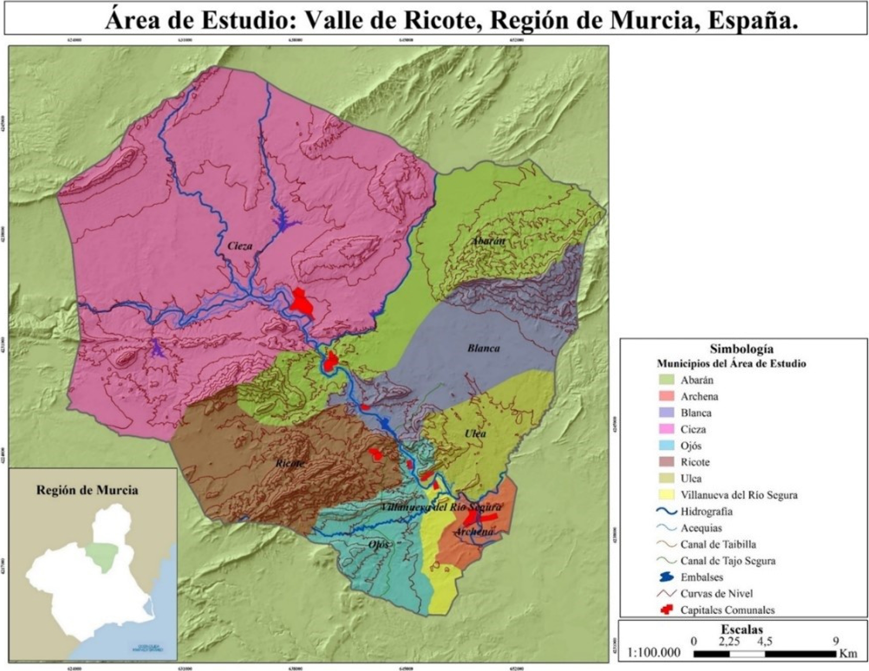
The Segura River, in the Vega Alta section known as the “Ricote Valley”, has taken advantage of a series of faults to cut through the Betic relief, which stretches from NE to SW in the central Murcia Region. Successive narrow channels cut through the mountain ranges (Menjú, Canales, Piedra Negra, Solvente, etc.), with other wider stretches passing through the intramontane depressions (Hoya de D. García, Abarán basin, Huerta de Arriba de Blanca, Huerta de Abajo de Blanca, etc.). The orchard is not continuous throughout the river valley; it is interrupted by rocky outcrops, so that the cultural landscape of the irrigation system forms a rosary of orchards, linked by the Segura River course (Gómez, 2015; Gil, 2015) (Figure 1).
-
Gómez, 2015La construcción y ampliación de los regadíos tradicionales e históricos en la Vega Alta del Segura: Sucesión de azudes y acequias, artilugios hidráulicos escalonados y motores de elevación de aguasIrrigation, Society and Landscape. Tribute Thomas F. Glick, 2015
-
Gil, 2015Paisajes culturales del regadío tradicional e histórico en la Vega Alta del SeguraIrrigation, Society and Landscape. Tribute Thomas F. Glick, 2015
Thumbnail
 Source: self-elaborated, by José Marcelo Bravo Sánchez, 2016.
Figure 1
Location of the Ricote Valley (Murcia region, Spain).
Location of the Ricote Valley (Murcia region, Spain).
Research consists of a regional geographical analysis of the hydraulic system (dam, intakes and pipelines), organized in the Menjú (Cieza area) and the authority in charge of water heritage and irrigation societies in the municipalities of Abarán and Blanca. We undertake a rural geographical study of irrigated areas that contrast markedly to the rest of the territory, which has a semi-arid environment like the Iberian Southeast (Gil, 2006). It is diachronic, because the analysis covers from 1613, the year when the Moors5 were expelled from the Ricote Valley, up to the current situation in 2023, assessing how the model for the diversion of perennial waters has evolved, focussed on a river course; nowadays regulated by a system of reservoirs, as occurs in the case of the Segura.
-
Gil, 2006Los paisajes agrarios de la Región de MurciaPapeles de Geografía, 2006
The study of this irrigation method divides into two types; the first uses water below the irrigation ditch and the other water that is elevated. On-foot.irrigation, using gates or below the ditch, is organized below the levels of the ditches, which adjust to the topography, in order to irrigate corners and groves along the river bank. The method that raises water from the river or from the ditches requires terracing the slopes of the river valley (with dry stone walls)6 and raising the water by means of traditional devices (water elevating hydraulic wheels of varying sizes), and by motors (steam engines, simple gas engines, diesel-oil engines and electric motors). These would spread throughout the valley, once hydroelectric plants, commonly known as light factories became established, supplying areas with electricity (the Menjú hydroelectric plant in Cieza, the Sagrados Corazones hydroelectric plant in Abarán, the Nicolás Gómez Tornero plant in Soto Damián, and the San Rafael hydroelectric plant in Blanca) (Gómez and Gil, 2014).
-
Gómez and Gil, 2014El patrimonio industrial del agua en la Cuenca de Segura. Recursos del Desarrollo territorial, 2014
The aim of this research was to undertake a regional geographic analysis of the Menjú agrosystem, hydraulic heritage, as well as native ethnobotany and biodiversity, and the associated cultural landscape7. Among the objectives of the research, was to indicate the difficulties-risks and the resources-potentialities, in order to propose sustainable strategies for the traditional and historical agrosocial irrigation model in the Vega Alta Segura.
Among relevant antecedents, we should mention publications by Glick on the Valencia orchard (Glick, 1988) and those by Herin on the Murcia orchards (Herin, 2012). Among the most recent works, those by Gómez and Gil on these irrigated areas and their governance stand out (Gómez, 2012; Gómez et al., 2022) and also those by Sanchis on adaption to climate change (Sanchis and Boelens, 2018; Sanchis et al., 2020, Sanchis et al., 2021).
-
Glick, 1988Regadío y Sociedad en la Valencia Medieval. Del Cenia al Segura, 1988
-
Herin, 2012Las huertas de Murcia, 2012
-
Gómez, 2012Elevación de aguas Para riego en la Cuenca del Segura. Cien años del Motor Resurrección (1912-2012), 2012
-
Gómez et al., 2022La gobernanza del agua de riego en la Región de MurciaCuadernos de Geografía, 2022
-
Sanchis and Boelens, 2018Gobernanza del agua y territorios hidrosociales: del análisis institucional a la ecología políticaCuadernos de Geografía, 2018
-
Sanchis et al., 2020Irrigation and water governanceWater Resources the Mediterranean Region, 2020
-
Sanchis et al., 2021El regadío mediterráneo y el cambio climático: un proceso de exaptaciónCambio climático en el Mediterráneo, 2021
THEORETICAL FRAMEWORK
The conceptual framework comprises cultural landscapes with traditional and historical irrigation (Hermosilla, 2010; Piqueras, 2013); concerning the link between irrigated agriculture and civilization (Palerm, 2002; Palerm and Martínez, 2009) write about the development of a culture of irrigation ditches (Rivera, 2009; Ponte, 2005); about water authorities (Palerm, 2015; Gimenez and Palerm, 2007; Gómez et al, 2022); on the heritage aspect (Hermosilla, 2011; Molinero and Tort, 2018); and likewise concerning the increase in cultural practices involving water management and procedures for the development of orchards in regions of North Africa, such as Testour in Tunisia (Hamrita and Rejeb, 2023).
-
Hermosilla, 2010Los regadíos históricos españoles. Paisajes culturales. Paisajes sostenibles, 2010
-
Piqueras, 2013Los paisajes culturales del agua. La cultura del agua en la Cuenca Mediterránea, 2013
-
Palerm, 2002Antología sobre pequeño riego, 2002
-
Palerm and Martínez, 2009Aventuras con el agua. La administración del agua de riego: historia y teoría, 2009
-
Rivera, 2009La cultura de la acequia. Agua y tierra y comunidad en el Suroeste de los Estados Unidos de América, 2009
-
Ponte, 2005De los caciques del agua a la Mendoza de las acequias. Cinco siglos de historia de acequias, zanjones y molinos, 2005
-
Palerm, 2015El Auto-Gobierno de Sistemas de Riego: Caracterización de la diversidad, 2015
-
Gimenez and Palerm, 2007Organizaciones tradicionales de gestión del agua: importancia de su reconocimiento legal para supervivencia. El caso de EspañaRegión y Sociedad, 2007
-
Gómez et al, 2022La gobernanza del agua de riego en la Región de MurciaCuadernos de Geografía, 2022
-
Hermosilla, 2011Atlas del Patrimonio Cultural Valenciano, 2011
-
Molinero and Tort, 2018Paisajes Patrimoniales de España, 2018
-
Hamrita and Rejeb, 2023Agua y patrimonio paisajístico morisco de Testour en Túnez, 2023
Two doctoral theses have recently been written on these historic irrigation systems. Bravo (2018) “Rural landscape and hydraulic heritage, outstanding examples from the rural culture of the Ricote Valley (Spain) and the Central zone of Chile” deals with the line of inheritance and seals of identity, as perceived by those who live in or visit the Ricote Valley. A seal of identity required by the water-elevating hydraulic wheels (the azudas) and the lesser hydraulic applications related to the milling industry stand out. These hydraulic devices are similar to those that exist in the central part of Chile (O’Higgins Region). Pastor’s (2018) “The historical and traditional irrigation systems of the Ricote Valley” focuses on irrigation culture and associated landscapes, with the history of irrigation by elevation in the section of the river valley between the Menjú and the Baños de Archena. It describes the construction of the Ricote raised garden, using water from a point of emission (the Fuente Grande) and water elevated from the Segura; focusing on the modernization process of the Huerta de Ricote, which conserves the inheritance of Water Heritage and the functionality of the Irrigation Community.
-
Bravo (2018)Paisaje rural y patrimonio hidráulico, referentes señeros presentes en la cultura rural del Valle de Ricote (España) y de la Zona Central de Chile, 2016
-
Pastor’s (2018)Los regadíos históricos y tradicionales del Valle de Ricote, 2018
METHODOLOGY
We initiate this study with an analysis of the bibliography and documentation from the Archive of the Hydrographic Confederation of Segura (AHCS), the General Archive of the Region of Murcia and the municipal archives of Abarán and Blanca. The bibliography included in the “cited literature” section was revised and consulted; this was complemented by field work in the section known as the Ricote Valley, in order to photograph the irrigation infrastructures and orchard landscapes that comprise the Menjú System. Several interviews were also undertaken with water managers (presidents of estates, societies and communities of irrigators) and also other irrigators, in order to perceive their opinion on the future of these historical irrigation systems. With this information, we undertook a diagnosis of strengths-weaknesses-opportunities-threats (SWOT), regarding irrigators and orchards. We had the opportunity to be in contact with experts in hydraulic and agronomic heritage, who seek to construct agricultural practice models, such as those of the Menjú System, recognized as a Globally Important Agricultural Heritage System (GIAHS)8.
The initial hypothesis is evidently correct; a crisis exists concerning the historical irrigation system, which even involves farms being abandoned, even though the water resources and heritage to sustain it still exist. Among the paramount objectives of the research are to present a model of perennial water diversion in a river such as the Segura River, to highlight the management of water for irrigation carried out by Heredamientos (estates with inherited rights), Water Societies and Irrigation Communities, to make a prognosis of the sustainability of these irrigation systems, with proposals for improvement to adapt and facilitate their continuity and future in climate change scenarios.
RESULTS
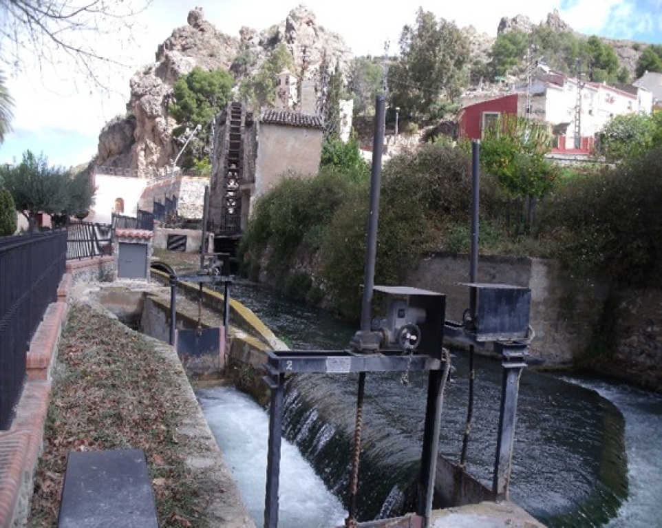
The Menjú hydraulic system is organized with reference to a dam on the Segura, which retains and raises the water to a sufficient height so that it can enter through the open intake to the extreme left end of the dam. Here the Abarán Canal initiated, which since 1805 has been the section that joins with the Blanca Canal, but which after the Molino Papel Division, divides once again to form the Principal Abarán and Principal or Mayor Blanca canals. The height of water created by the dam also made it possible to open the Charrara Canal intake on the right bank in 1727 (Figure 2).
Thumbnail
 Source: authors (15-03-2023).
Figure 2
Azud del Menjú dam on la Vega Alta of the River Segura (Cieza).
Azud del Menjú dam on la Vega Alta of the River Segura (Cieza).
The Report for the 1933 Hydrological Plan, describes the Menjú dam: “The Menjú Dam is located 215.65 kilometers from the source of the Segura River, in the Cieza area, but very close to the Abarán area. It is made of planks and dry stone, and stands at a height of one meter above the river bed. Two irrigation ditches emerge from this dam, one on each bank; these irrigate the Abarán and Blanca areas and some of the Cieza area, where it is located” (Arévalo, 1933). The water course on the left bank was thus described in 1933: “From the dam and on the left bank, the Abarán and Blanca irrigation ditch emerges, which runs first through the Cieza area for about 100 meters, crossing the Rambla del Moro by means of an aqueduct and then enters the Abarán area, where it irrigates directly and also by means of lifting devices. On reaching the paper mill, the irrigation ditch forks into two channels, known as the Principal de Abarán and Principal de Blanca, respectively. The Blanca irrigation ditch takes two thirds of the flow and the Abarán irrigation ditch the remaining third. The Abarán irrigation ditch tails off in the Barranco de La Carraila, where the Resurrección’s propulsion engines are located. The Blanca irrigation ditch ends in the river, near the Solvente dam” (Arévalo, 1933) (Figure 3).
-
Arévalo, 1933Memoria para el Plan Nacional de Obras Hidráulicas 1932/33, 1933
-
Arévalo, 1933Memoria para el Plan Nacional de Obras Hidráulicas 1932/33, 1933
Thumbnail
 Source: authors (30/11/2017).
Figure 3
Paper Mill diversion on the left bank of the Segura, Las Canales neighborhood.
Paper Mill diversion on the left bank of the Segura, Las Canales neighborhood.
From these channels (ditches) using a system of gates, opened and closed with planks, the land situated below the level of the ditch is irrigated; these constitute on-foot irrigation systems, using a gate or below a “ditch”. Land above the level of the ditch is irrigated with water raised by traditional devices such as hydraulic wheels (Banegas and Gómez, 1992) and also by propulsion motors, consisting of irrigation by elevation. In the water wheel census for agricultural use in 1929, 62 devices were included in the Azud del Menjú to the Azud del Solvente. Of these, 38 were water powered irrigation wheels, with some hand pumps; these raised water from the Abarán and Blanca ditches, on the left bank of the Segura (Figure 4); on the right bank, 21 devices were connected to the Charrara irrigation channel and 3 to the turbine of the Noria and Campillo heritage (Gómez, 2012). Some of these are still in operation (such as those of D. García, la Grande, Candelón and Ñorica; all in Abarán), declared a site of cultural interest, in the category of place of ethnographic interest (Official Bulletin of the Region of Murcia-BORM, 163, 2016). Procedures undertaken by “entrepreneurs” interested in irrigation and the availability of technological improvements such as electric motors, resulted in a large part of the traditional devices being replaced by motors by the end of the 19th century and during the first decades of the 20th century (Gómez, 1983; Gómez, 1983a). Having greater propulsion power, these motor pump conglomerations permitted more water to be pumped to a greater height. Irrigation societies were created with initiatives such as the Motor Resurrección. In 1912, the Estate of the Main Ditch of Abarán, yielded a flow of 200 liters/second, to be propelled to a geometric height of 134.10 meters by this motor, so as to irrigate more than 600 hectares of dry land of Casa Alcántara, Casa Matías, Barranco Molax, Casa Pelona, Hoya del Campo, Casa Marín, Cañaicas; places in the northeast of the Abarán municipality and far from the narrow reach of the river valley (Gómez, 2012).
-
Banegas and Gómez, 1992Consideraciones sobre el funcionamiento de ruedas de corriente elevadoras de agua en el tramo alto del Valle del SeguraPapeles de Geografía, 1992
-
Gómez, 2012Elevación de aguas Para riego en la Cuenca del Segura. Cien años del Motor Resurrección (1912-2012), 2012
-
Official Bulletin of the Region of Murcia-BORM, 163, 2016Resolución de 29 de junio de 2016 de la Dirección General de Bienes Culturales por la que se incoa procedimiento de declaración de bien de interés cultural, con categoría de lugar de interés etnográfico, a favor de las norias de Abarán, en los términos municipales de Abarán y Cieza, 2016
-
Gómez, 1983Abarán, centro de producción y comercialización de productos agrarios. Caja de Ahorros de Murcia. Caja de Ahorros de Alicante y Murcia, 1983
-
Gómez, 1983aLa huella del riego en el paisaje de Abarán. El regadío tradicional, 1983
-
Gómez, 2012Elevación de aguas Para riego en la Cuenca del Segura. Cien años del Motor Resurrección (1912-2012), 2012
Thumbnail
 Source: authors (15/03/2023).
Figure 4
Diversion towards the joint section of the Abarán and Blanca irrigation ditches, on the left bank of the Segura (Menjú-Cieza).
Diversion towards the joint section of the Abarán and Blanca irrigation ditches, on the left bank of the Segura (Menjú-Cieza).
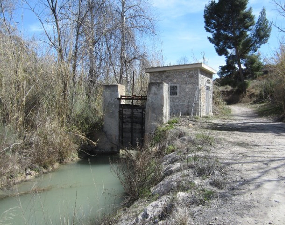
In the Water Registry of the Segura Basin, in February 2008, the Acequia Charrara diversion was recorded as having existed since 1727, directly from the right bank of the Segura River, flowing as a result of gravity and taking advantage of the elevation of the water that occurred at that point thanks to the Menjú Dam (Figure 5). This would reach a flow of 3.7 cubic hectometers per year to irrigate a crop surface of more than 500 hectares (that is, a maximum flow of 600 liters per second, approximately 7,525 cubic meters per hectare, per year). Along its route of approximately 9.5 kilometers, it had two historic low-flow water wheels that are still operating; the Candelón and Ñorica wheels.
Thumbnail
 Source: authors (11/03/2023).
Figure 5
Diversion of the Charrara Canal, on the right bank of the Segura (Menjú-Cieza).
Diversion of the Charrara Canal, on the right bank of the Segura (Menjú-Cieza).
In order to avoid replacing the weir used by the Blanca irrigation canal in Las Canales, which was destroyed in 1805 by a catastrophic flood that eliinated several weirs, in 1807 an agreement was reached between the estates of the Abarán and Blanca irrigation canals, to share the Menjú weir. Francisco Lician (a hydraulic works expert) was hired to expand the Peñasco mines and facilitate the passage of a greater volume of water through the section of irrigation canal connecting the Menjú and Las Canales. A water division was established between the two irrigation canals at the exit of the mines. He also designed a low-flow water-elevating wheel, La Noria Grande, which began to operate in 1807 (Figure 6). In the Las Canales area, the Molino de Papel industrial complex (paper mill, fulling mill and industrial sawmill) would also be developed, using water to create the energy (Gómez, 1991).
-
Gómez, 1991Tecnología del agua en la Región de Murcia: uso de ruedas de corriente, 1991
Thumbnail
 Source: authors (20/10/2017).
Figure 6
Low-flow waterwheel in Abarán, the Great Waterwheel or the Paper Mill.
Low-flow waterwheel in Abarán, the Great Waterwheel or the Paper Mill.
In 1850, irrigated land in the Segura river valley, in Abarán and Blanca consisted of 123 hectares; 44.77 and 78.26 hectares, respectively (Madoz, 1850). Most of this area was located on the left bank, and more than two thirds was irrigated by irrigation ditches.
-
Madoz, 1850Diccionario Geográfico-Estadístico-Histórico de España y sus posesiones de Ultramar. Edición facsímil, por la Consejería de Economía, Industria y Comercio de la CARM, de las voces referidas a Región de Murcia, 1850
One hundred and thirty years later, in 1980, 1,050 hectares were irrigated in Abarán with water from the Segura River and 375 in Blanca. Most of the land was irrigated by elevation; in the first area production predominantly consists of stone fruit trees with citrus trees in the second (Gil and Gómez, 1985; Avellaneda et al, 1983).
-
Gil and Gómez, 1985Modificaciones del paisaje rural en la Vega AltaAREAS, Revista de Ciencias Sociales, 1985
-
Avellaneda et al, 1983Riego y Agricultura en Abarán y Blanca, 1983
Today, in 2023, 1,190 hectares are irrigated on the left bank of the Segura, managed by 1,320 irrigators (Table 1). However, most of this corresponds to irrigation on the part of the Resurrección Motor and to Group 1,485, located outside the valley, in backcountry areas such as Hoya del Campo, Venta de la Aurora, Vergeles, Rellano, etc.
Table 1
Irrigated land on the left bank of the Segura (section between the Menjú dam and the Ojós dam), in the Abarán and Blanca areas.
Irrigated land on the left bank of the Segura (section between the Menjú dam and the Ojós dam), in the Abarán and Blanca areas.
| Community | Areas |
% | Irrigators |
% |
| Noria de la Hoya de D. García | 41.40 | 3.48 | 54 | 4.09 |
| Motor San Pablo | 14.00 | 1.18 | 42 | 3.18 |
| Noria Grande or the Paper Mill | 1.10 | 0.09 | 6 | 0.45 |
| Motor Resurrección | 640.50 | 53.82 | 663 | 50.23 |
| Motor Group 1485 | 220.00 | 18.49 | 260 | 19.70 |
| Motors of the Blanca Acequia (El Progreso, Saque and Navela, etc.) | 212.90 | 17.89 | 190 | 14.39 |
| On foot irrigation, using gates below a ditch | 60.10 | 5.05 | 105 | 7.96 |
| Total | 1,190.00 | 100.00 | 1,320 | 100.00 |
An analysis of traditionally irrigated areas, on the right bank of the Segura in 2023, estimated to be an irrigated area of 490 hectares, managed by 1,192 irrigators (Table 2).
Table 2
Irrigation on the right bank of the Segura (Abarán and Blanca terminals).
Irrigation on the right bank of the Segura (Abarán and Blanca terminals).
| Community | Areas |
% | Irrigators (number) | % |
| Noria de Candelón | 1.68 | 0.34 | 15 | 1.26 |
| Virgen del Oro Motor | 108.22 | 22.09 | 263 | 22.06 |
| Calvo Sotelo Motor | 28.00 | 5.72 | 125 | 10.49 |
| Ñorica | 0.80 | 0.16 | 1 | 0.008 |
| Santa Cecilia Motor | 24.00 | 4.90 | 139 | 11.66 |
| Asunción Motor | 47.00 | 9.59 | 162 | 13.59 |
| El Llano Motor | 1.50 | 0.31 | 10 | 0.84 |
| Triunfo Motor | 138.00 | 28.17 | 195 | 16.36 |
| Corona Motor | 36.00 | 7.35 | 104 | 8.72 |
| Barranco or the Conde Motor | 20.01 | 4.08 | 17 | 1.43 |
| Noria and Campillo Estate | 68.50 | 13.98 | 82 | 6.88 |
| On foot irrigation, using gates below a ditch | 16.20 | 3.331 | 79 | 6.63 |
| Total | 490.00 | 100.00 | 1,192 | 100.00 |
The structure of the agricultural holdings irrigated by the Menjú System shows the predominance of small farms of less than 1 hectare. On the right bank of the river, using irrigation by elevation, more than half of the irrigable area (55.33%) and five sixths of the irrigators (92.06%) correspond to farms of less than 1 hectare. Only the Triunfo Motor community and the Noria and Campillo communities have farms and irrigators within the irrigable area that combine farms of more than 5 hectares (Table 3).
Table 3
Structure of farms in the Menjú elevated irrigation system on the right bank of the Segura River.
Structure of farms in the Menjú elevated irrigation system on the right bank of the Segura River.
| Community | <1 ha | From 1 to 3 ha | From 3.01 to 5 ha | From 5.01 to 20 ha | Total | |||||||||
| Irrig | Area | Irrig | Area | Irrig | Area | Irrig | Area | Irrig | Area | |||||
| Motor Calvo Sotelo | 122 | 21.00 | 3 | 7.00 | - | - | - | - | 125 | 28.00 | ||||
| Virgen del Oro | 249 | 72.82 | 12 | 26.30 | 2 | 9.10 | - | - | 263 | 108.22 | ||||
| Motor Santa Cecilia | 136 | 20.55 | 3 | 4.45 | - | - | - | - | 139 | 25.00 | ||||
| Motor Asunción | 155 | 35.30 | 7 | 11.70 | - | - | - | - | 162 | 47.00 | ||||
| Motor El Triunfo | 159 | 51.79 | 29 | 44.65 | 3 | 10.74 | 4 | 31.72 | 195 | 139.90 | ||||
| Motor Corona | 94 | 20.50 | 10 | 16.30 | - | - | - | - | 104 | 36.80 | ||||
| Noria y Campillo | 70 | 28.40 | 6 | 10.19 | 1 | 4.00 | 5 | 26.00 | 82 | 68.59 | ||||
| Total | 985 | 250.36 | 74 | 120.59 | 6 | 23.84 | 9 | 57.72 | 1,070 | 452.51 | ||||
| % | 92.06 | 55.33 | 6.54 | 26.65 | 0.56 | 5.27 | 0.84 | 12.75 | 100.00 | 100.00 | ||||
On the left bank of the Segura, in the municipality of Abarán, the two irrigation communities with the largest farms are Motor Resurrección and Group 1,485, both with most of their irrigable surface outside the narrow limitations of the river valley. They have two large elevated water areas, fed from the tail of the Abarán Main Ditch, at a height of more than 140 meters, to Cabezo del Piricú or La Mina; from that summit, the water of the Segura reaches the land of places including Casa Alcántara, Barranco Molax, Hoya del Campo, Vergeles, Venta de La Aurora, Balsa Redonda, Casa Marín by gravity, etc. (Figure 7).
Thumbnail
 Source: authors (29/10/2016).
Figure 7
Electric motors of Group 1,485.
Electric motors of Group 1,485.
On the left bank, but in the Blanca area, the use of water for irrigation, for farms exceeding 5 hectares, by the I.C. (irrigation canal) of the Acequia de Blanca Estate (including those irrigated by the Motor Progreso) and above all, by the I.C. of Zone II (Blanca) of Vegas Alta and Media, (Table 4), also mainly outside the Segura valley.
Table 4
Layout of farms in the Acequia de Blanca Estate irrigated by the I.C. of Zone II (Blanca) Vegas Alta and Media (high and low).
Layout of farms in the Acequia de Blanca Estate irrigated by the I.C. of Zone II (Blanca) Vegas Alta and Media (high and low).
| Area | Ac. Blanca Estate | Zona II (Blanca) | |||||||
| Irrig | % | Ha | % | Irrig | % | Ha | % | ||
| Less than 1 ha | 6 | 31.58 | 3.54 | 1.46 | 225 | 46.78 | 107.34 | 3.63 | |
| From 1 to 3 ha | 2 | 10.53 | 4.11 | 1.69 | 121 | 25.16 | 215.88 | 7.27 | |
| From 3.01 to 5 ha | 2 | 10.53 | 8.57 | 3.53 | 36 | 7.48 | 145.03 | 4.90 | |
| From 5.01 to 20 ha | 6 | 31.58 | 46.01 | 19.94 | 69 | 14.34 | 658.90 | 22.26 | |
| From 20.01 or more | 3 | 15.79 | 180.70 | 74.39 | 30 | 6.24 | 1832.76 | 61.92 | |
| Total | 19 | 100.00 | 242.92 | 100.00 | 481 | 100.00 | 2951.91 | 100.00 | |
The I.C. of Zone II has among its water resources, a supply of water from the Segura (in the form of traditional irrigation), to which groundwater is added (especially from the Ascoy-Sopalmo aquifer, which was initially used for new irrigation projects). Since 1980, this has also been supplied by water from the Tajo-Segura Transfer, to which is added recycled water from the Blanca Wastewater Treatment Plant (WWTP). Given the decrease in water transfers from the Tajo Basin in recent years, the water mix has had to be topped up with desalinated water (Table 5).
Table 5
Origin of water used in the I.C. of Zone II (Blanca) Vegas Alta and Media.
Origin of water used in the I.C. of Zone II (Blanca) Vegas Alta and Media.
| Origin | Volume (m3) | % in terms of origin | Media |
| Water from Segura rivers | 21,319,077 | 50.94 | 4,263,815.4 |
| Trasvase Tajo-Segura | 10,066,799 | 24.05 | 2,013,355.8 |
| Aquifer wells | 4,625,001 | 11.05 | 925,000.2 |
| Recycled water (EDAR) | 1,955,000 | 4.67 | 391,000.0 |
| Assignment of rights and drought wells | 2,224,833 | 5.32 | 444,966.6 |
| Desalinated water | 1,662,983 | 3.97 | 332,596.6 |
| Total | 41,853,693 | 100.00 | 8,370,738.6 |
Rich biodiversity is characteristic of crops grown in the Ricote valley. Along with aerial crops, soil crops are also grown (vegetables and tubers, aromatic and medicinal plants, etc.), all adapted to the eco-topological conditions of the river valley and surrounding area and to historical cultural practices, which constitute the typical identity of the Moorish orchards. In terms of landscape, in the irrigated oases that dot the Betic relief, the date palm (Phoenix dactylifera L.) stands out as a predominant image along with the low-flow water wheels (azudas and norias).
In the geographical area of the Menjú System, among the range of uses, evidently soil crops predominate in the case of on-foot irrigation, whereas in the groves, corners and terraces close to the river’s course and dispersed throughout the area, there are date palms, orange, lemon, pear and medlar trees, etc. (Figure 8).
Thumbnail
 Source: authors (29/03/2023).
Figure 8
Soil crops with some aerial species in Cañada de Hidalgo, on the right bank of the Segura (municipal district of Abarán).
Soil crops with some aerial species in Cañada de Hidalgo, on the right bank of the Segura (municipal district of Abarán).
In the elevated irrigation system that has dominated the valley slopes (high river terraces and slopes), crops such as citrus and fruit trees predominate. In terms of their distribution, orientation is very important. If altitude reduces the risk of inversion frosts, orientation towards the sun favors ripening. Thus, in the sun of Sierra del Oro, early varieties of stone fruit are grown, which are put on the market a few days or weeks earlier. In Abarán, at a higher altitude and further north, where there are more hours of cold, stone fruit trees such as apricot and peach trees predominate (Figure 9). In Blanca, citrus trees are most common, especially lemon trees of the “Berna” and “Fino” varieties.
Thumbnail
 Source: authors (15/03/2023).
Figure 9
Stone fruit trees in bloom, in the San Pablo Motor irrigation system in the Hoya de D. García, on the left bank of the Segura (in the municipality of Abarán).
Stone fruit trees in bloom, in the San Pablo Motor irrigation system in the Hoya de D. García, on the left bank of the Segura (in the municipality of Abarán).
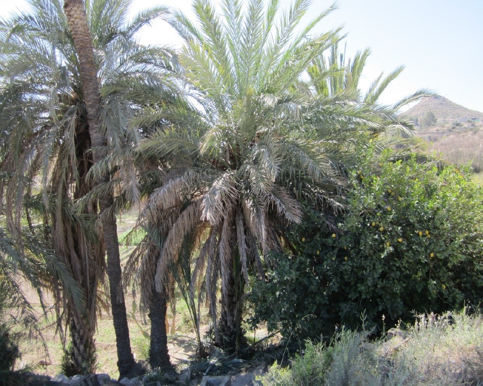
Varieties of citrus fruits, which must be Valricotes are still found here, as currently these are not found outside this area. These are citrus varieties that stand out for their aromatic properties, such as the bergamot (Citrus bergamis L.) and the citrus lemon (Citrus médica L.). The former is very aromatic, with a flattened lemon shape and very smooth skin. These are traditionally used in confectionery and even perfumery, as is the lemon, which is highly sought after by confectioners (Rivera and Obón, 1998) (Figure 10).
-
Rivera and Obón, 1998Las variedades tradicionales de frutales de la cuenca del río Segura. Catálogo etnobotánico. Cítricos, frutales carnosos y vides, 1998
Thumbnail
 Source: authors (29/03/2023).
Figure 10
Date palm and citrus lemon tree, irrigated by flooding with water from the Segura, by means of the Charrara Canal.
Date palm and citrus lemon tree, irrigated by flooding with water from the Segura, by means of the Charrara Canal.
DISCUSSION
Concerning the social organization of water distribution for irrigation, usage has been established in Water Estates, in Civil Property Societies and in Irrigation Communities. Distribution includes all those estates that receive water from the same intake, thus, in the Menjú System, on the right bank of the Segura River, one Estate consists of Users of the Charrara Ditch. In this case, the Civil Property Societies consist of groups of irrigators interested in elevating water for irrigation; an example is the Asunción Society. As regards the Irrigation Community, Water Law 29/1985 designates this as an organization that directs the collective uses of public waters that they share – both surface and underground –; for example the I.C. of Virgen del Oro.
Article 81 in the Revised Text of the Water Law (RTWL) specifies that “irrigation communities consist of organizations that have the autonomy to draft and approve their Statutes and Ordinances and to exploit public benefits inherent to their use”. Researchers Giménez and Palerm, 2007, affirm that these are autonomous and represent an example of functional decentralization; the State does not appoint their representatives, nor does it finance them (Giménez and Palerm, 2007). In a recent work by Gómez et al., 2022., they indicate that if the State protects them, “The Hydrographic Confederations will ensure they comply with statutes and ordinances” (Gómez et al., 2022).
-
Giménez and Palerm, 2007Organizaciones tradicionales de gestión del agua: importancia de su reconocimiento legal para supervivencia. El caso de EspañaRegión y Sociedad, 2007
-
Giménez and Palerm, 2007Organizaciones tradicionales de gestión del agua: importancia de su reconocimiento legal para supervivencia. El caso de EspañaRegión y Sociedad, 2007
-
Gómez et al., 2022La gobernanza del agua de riego en la Región de MurciaCuadernos de Geografía, 2022
-
Gómez et al., 2022La gobernanza del agua de riego en la Región de MurciaCuadernos de Geografía, 2022
This diagnosis manifests itself in the SWOT matrix (Table 6). In summary, weaknesses consist of: W1. Limited arable land; W2. Difficulties presented by the terrain; W3. Small farm size; Threats: T1. Low farming profitability; T. Fluctuations and increases in energy prices; T3. Expansion of urban land, at the expense of orchards. Strengths: S1. Availability of ample, good quality water; S2 Rich natural and cultural heritage; S3. Landscape variety and biodiversity. Opportunities: O1. Existence of funds for re-evaluating heritage; O2. Technology and energy efficiency; O3. Political and social support for the GIAHS proposal.
Table 6
SWOT analysis of landscape and heritage in the Ricote Valley.
SWOT analysis of landscape and heritage in the Ricote Valley.
| Weaknesses | Strengths |
| The layout of the relief and the course of the Segura River create an asymmetrical river valley in the shape of a rosary, where there are narrows and basins or hollows that necessitate compartmentalization into various systems of dams and irrigation ditches. | Availability of ample, good quality water for the rosary of orchards in the river valley and for the Ricote orchard-oasis. |
| The steep slope of the river valley's hillsides requires terracing (with dry stone walls) and pumping to raise the water with electric motors, requiring energy expenditure. | Rich natural and cultural heritage, with characteristic features such as low-flow wheels (azudas-norias) and dry stone walls (hormas). |
| The small size of most agricultural holdings results in limited supply of products and does not allow for full-time dedication on the part of the farmer-irrigator. | Traditional Moorish cultural landscape, with aerial crops and soil of ethnobotanical interest that promote biodiversity |
| Threats | Opportunities |
| Abandonment of agricultural plots due to the low profitability of the crop. Reduced participation, resulting in greater expenses to be shared between heirs and commoners. | Investments to recover the hydraulic and cultural heritage of the Ricote Valley, using funds such as Next Generation EU. |
| Fluctuations and increases in energy prices, accounting for more than half of the total operating costs of irrigation by elevation | Development of energy efficient projects for the Rural Development Programs in the Murcia Region (as contemplated in the 2014-2020 RDP) |
| Expansion of urban centers at the expense of orchards, with the consequent loss of fertile areas and hydraulic heritage. | Initiative which proposes the Ricote Valley as a Globally Important Agricultural Heritage System (GIAHS). |
In recent years, the agro-social systems created by the Menjú hydraulic complex (dam-ditches) for irrigation on both banks of the river have presented weaknesses and threats that have led to a significant reduction in irrigated area. This has happened with the Noria Grande or Molino Papel Estate, which irrigated more than 18 hectares in the mid-twentieth century due to the urban expansion of the Abarán nucleus, extended at the expense of the orchard, leaving scarcely more than 1 hectare under cultivation, causing the agricultural holdings in places such as Cañada de Morzaletes and Bajo Solana to disappear (Figure 11).
Thumbnail
 Source: authors (April, 2023).
Figure 11
Plan showing plots of irrigable land in the Segura river valley in the municipality of Abarán.
Plan showing plots of irrigable land in the Segura river valley in the municipality of Abarán.
Likewise, urban expansion in the Blanca core and the Azud de Ojós reservoir basin have eliminated a large part of the irrigated area under the Huerta Baja de Blanca irrigation ditch. This is the case in the irrigated area of the Ciecón or the Molino and that of the Rival irrigation ditch and even part of the Bayna orchard has experienced the disappearance of the old agricultural holdings, as they have been converted into service areas, such as the Municipal Sports Centre and the Parque de las Cuevas (Molina and Gómez, 2016) (Figure 12).
-
Molina and Gómez, 2016El riego tradicional e histórico de las acequias Principal de Abarán y de Blanca, en la margen izquierda del Segura, 2016
Thumbnail
 Source: authors (20/10/2017).
Figure 12
Blanca’s low-lying orchard threatened by urban expansion and the Azud de Ojós reservoir.
Blanca’s low-lying orchard threatened by urban expansion and the Azud de Ojós reservoir.
An increase in energy prices makes many traditional irrigation projects with electric motors economically unsustainable. In 2022, some of these irrigation companies paid 0.40 euros per cubic meter of water, more than half of which corresponded to the cost of electricity.
Modernize of irrigation is crucial (more than 1.5 million hectares have been modernized in Spain in the last fifty years); however preserving the heritage of traditional irrigation infrastructures and their functionality has occurred as part of the modernization carried out by the Ricote Irrigation Community (Baraja et al., 2006; Gómez, 2019).
-
Baraja et al., 2006Atlas de los regadíos de la cuenca del Duero, 2006
-
Gómez, 2019Modernización de regadíos en España: experiencias de control, ahorro y eficacia en el uso del agua para riegoAgua y Territorio, 2019
Among the strengths and opportunities, it is worth highlighting the availability of quantity and quality water (from surface resources of the Segura Basin) with allocations in terms of irrigation concessions, ranging from 4,500 m3/ ha/year, up to 7,500 m3/ha/year. The regulatory fee for the Segura Basin is affordable, with a cost of 14.44 euros/ha/year, for traditional irrigation ,prior to 1933 and 15.49 euros/ha/year, for those joining after 1933 (BORM, 2022). It is also worth highlighting the value attributed to hydraulic infrastructures and irrigated cultural landscapes, which form an attraction in terms of water routes, itineraries and hikes that attract visitors, such as the norias route or the route of flowers (Gil et al., 2020).
-
BORM, 2022Resolución de 29 de junio de 2016 de la Dirección General de Bienes Culturales por la que se incoa procedimiento de declaración de bien de interés cultural, con categoría de lugar de interés etnográfico, a favor de las norias de Abarán, en los términos municipales de Abarán y Cieza, 2016
-
Gil et al., 2020Las norias como recurso turístico y seña de identidad del Valle de Ricote (Región de Murcia-España)Gran Tour, Revista de Investigaciones Turísticas, 2020
From the Azud del Menjú to the Azud de Ojós, there is a network of hydraulic infrastructures (ditches, irrigation equipment, waterwheels, water pumping motors, aqueducts, siphons, etc.), which have been used to distribute the waters of the Segura River and create cultural landscapes of discontinuous and terraced irrigation, such as the Valricotie orchards (of Moorish origin). There is rich material heritage declared as a Site of Cultural Interest (BIC) that includes the water wheels, which combines with intangible knowledge of agricultural practices and about the biodiversity of crops, pertinent for aspiring to the System of Global Importance of Agricultural Heritage (GIAHS). These are aspects that the Food and Agriculture Organization of the United Nations (FAO) have already recognized in more than 60 places around the world.
CONCLUSIONS
Maintaining these applications and the landscapes generated requires seeking to make them sustainable for their users, posing challenges. One of these is the need to improve water storage, at the level of societies and communities of irrigators. On the right bank, only the Virgen del Oro Irrigation Community has two large-capacity reservoirs (70,000 m3 between them) and some irrigators of the Triunfo and Asunción Motors have their own reservoir. On the left bank, Motor Resurrección and Group 1,485 have large reservoirs (Moaire, Asomada and Casa Alcántara), but these are insufficient to fulfill the pressure requirements for local irrigation. There is a need to limit pumping and boost electricity during the hours of lowest cost (in 2022, this accounted for more than half the hourly cost of water and caused an increase in non-payments for irrigation distribution). In addition to reservoirs that dictate the irrigable perimeters, energy saving measures are necessary, in the form of power inverters, installations that avoid losses throughout the networks, while moving towards self-consumption, by using small photovoltaic energy parks, for example.
The size of the farms (small ones predominate) reduces the volume to be marketed after the harvest, meaning that production must be directed to nearby markets. Bureaucracy that has been imposed because of the need to assess product traceability; however long distances prohibit many traditional farmers from being able to market, as well as leaving them defenseless against marketing agents. Cooperative methods related to the creation of brands to identify these products can serve to increase their value (origin, quality, etc.) and make them more profitable. Production from most farms does not allow full-time dedication on the part of the farmer-irrigator and current production scarcely enters into foreign marketing circuits (exports). To encourage the preservation of these cultural landscapes and agro-social systems, the proposal for Globally Important Agricultural Heritage Systems (GIAHS) should contribute to the validity of local products and the tangible and intangible heritage of the cultural landscapes of the orchards of the Ricote Valley in the Vega Alta del Segura.
These constitute proposals for procedures that will benefit the environmental, social and economic sustainability of the weir-ditch model, with the aim of maintaining the orchards, while complying with the model for rural landscapes of heritage and cultural interest.
ACKNOWLEDGMENTS
This research has been carried out within the framework of the Grants for the Requalification of the Spanish University System, financed by the European Union - Next Generation EU.
REFERENCES
- Arévalo E. 1933. Memoria para el Plan Nacional de Obras Hidráulicas 1932/33. (Documento fotocopiado gracias a la generosidad de D. Julio Muñoz y D. Miguel Carrasco). Dirección de Obras Hidráulicas de Segura: Murcia, España. 346 p. Links
- Avellaneda DJ, García A, López S, Rodríguez A. 1983. Riego y Agricultura en Abarán y Blanca. Concejalía de Cultura del Ayuntamiento de Abarán: Cieza, España. 156 p. Links
- Banegas J, Gómez JM. 1992. Consideraciones sobre el funcionamiento de ruedas de corriente elevadoras de agua en el tramo alto del Valle del Segura. Papeles de Geografía, 18. 87-104. Links
- Baraja E. 2006. Atlas de los regadíos de la cuenca del Duero. Universidad de Valladolid: Valladolid, España, 339 p. Links
- BORM (Boletín Oficial de la Región de Murcia). 2016. Resolución de 29 de junio de 2016 de la Dirección General de Bienes Culturales por la que se incoa procedimiento de declaración de bien de interés cultural, con categoría de lugar de interés etnográfico, a favor de las norias de Abarán, en los términos municipales de Abarán y Cieza. pp: 22710-22718. Links
- Bravo JM. 2016. Paisaje rural y patrimonio hidráulico, referentes señeros presentes en la cultura rural del Valle de Ricote (España) y de la Zona Central de Chile. Tesis Doctoral. Universidad de Murcia: Murcia, España. Links
- Bravo JM, Gil E, Naranjo G. 2016. Relevancia de norias y molinos en la economía rural del Valle de Ricote. In: García, R, Alonso F, Belmonte F y Moreno D (eds). XV Coloquio Ibérico de Geografía. Retos y tendencias de la Geografía Ibérica. Universidad de Murcia, Asociación Española de Geógrafos (AGE), Asociación Portuguesa de Geógrafos (APG): Murcia, España, pp: 939-951. Links
- Cruz L. 2017. El agua como generador de paisajes culturales: Una visión desde el Plan Nacional del Paisaje Cultural. In: Paisajes Culturales del Agua. Servicio de Publicaciones de la Universidad de Extremadura: Cáceres, España; pp: 17-36. Links
- Gil E. 2015. Paisajes culturales del regadío tradicional e histórico en la Vega Alta del Segura. In: Irrigation, Society and Landscape. Tribute Thomas F. Glick. Universidad Politécnica de Valencia: Valencia, España, pp: 856-867. Links
- Gil E. 2006. Los paisajes agrarios de la Región de Murcia. Papeles de Geografía, (43). 19-30. Links
- Gil E, Gómez JM. 1985. Modificaciones del paisaje rural en la Vega Alta. AREAS, Revista de Ciencias Sociales, 5: 23-36. Links
- Gil E, Gómez JM. 2018. Los paisajes patrimoniales del Valle de Ricote. Seña de identidad del medio rural en la Vega Alta del Segura. In: Molinero F y Tort J (coords). Paisajes patrimoniales de España. Tomo III. Ministerio de Agricultura, Pesca y Alimentación. Ministerio para la Transición Ecológica. Universidad Autónoma de Madrid: Madrid, España; pp: 1136-1151. Links
- Gil E, Bravo JM, Bernabé MB, Gómez JM. 2020. Las norias como recurso turístico y seña de identidad del Valle de Ricote (Región de Murcia-España). Gran Tour, Revista de Investigaciones Turísticas, 22. 71-96. Links
- Giménez M, Palerm J. 2007. Organizaciones tradicionales de gestión del agua: importancia de su reconocimiento legal para supervivencia. El caso de España. Región y Sociedad, 19(38). 1-12. Links
- Glick TF. 1988. Regadío y Sociedad en la Valencia Medieval. Del Cenia al Segura. PUV: Valencia, España. 413 p. Links
- Gómez JG. 2023. Consideraciones sobre la inestabilidad de laderas en la Cuenca de Abarán-Blanca. Morfodinámica reciente y medidas adoptadas: las hormas o muros de piedra seca. In: II Congreso de Historia en torno a los Moriscos Expulsos: Ojós, España. pp: 355-372. Links
- Gómez JM. 1983. Abarán, centro de producción y comercialización de productos agrarios. Caja de Ahorros de Murcia. Caja de Ahorros de Alicante y Murcia. Ayuntamiento de Abarán: Molina de Segura, España. 145 p. Links
- Gómez JM. 1983a. La huella del riego en el paisaje de Abarán. El regadío tradicional. Edita Grupo “Abarán V Centenario”: Murcia, España. 18 p. Links
- Gómez JM. 1991. Tecnología del agua en la Región de Murcia: uso de ruedas de corriente. In: V Congreso de la Sociedad Española de Historia de las Ciencias y las Técnicas. DM y PPU: Murcia. España. pp: 337-353. Links
- Gómez JM. 2012. Elevación de aguas Para riego en la Cuenca del Segura. Cien años del Motor Resurrección (1912-2012). Regional Campus International Excellence “Campus Mare Nostrum”. Fundación Séneca, Comunidad de regantes Motor resurrección: Murcia, España. 143 p. Links
- Gómez JM. 2015. La construcción y ampliación de los regadíos tradicionales e históricos en la Vega Alta del Segura: Sucesión de azudes y acequias, artilugios hidráulicos escalonados y motores de elevación de aguas. In: Irrigation, Society and Landscape. Tribute Thomas F. Glick. Universidad Politécnica de Valencia. Valencia: Valencia, España. pp: 402-415. Links
- Gómez JM. 2019. Modernización de regadíos en España: experiencias de control, ahorro y eficacia en el uso del agua para riego. Agua y Territorio, 13. 69-76. Links
- Gómez JM, Gil E. 2014. El patrimonio industrial del agua en la Cuenca de Segura. Recursos del Desarrollo territorial. In: VII Congreso Internacional de Ordenación del Territorio (CIOT). Madrid, 27, 28 y 29 de noviembre de 2014. Madrid, España. Links
- Gómez JM, Gómez JM, Gil E. 2022. La gobernanza del agua de riego en la Región de Murcia. Cuadernos de Geografía, 108-109(1). 213-237. https://doi.org/10.7203/CGUV.108.23778. Links
- Hamrita A, Rejeb H. 2023. Agua y patrimonio paisajístico morisco de Testour en Túnez. In: VII Congreso Nacional y I Congreso Internacional de la Red de Investigadores Sociales sobre Agua (RISSA). La crisis del agua del siglo XXI: retos y perspectivas. Del 27 al 31 de marzo de 2023 en México. Links
- Herin R. 2012. Las huertas de Murcia. Real Academia Alfonso X El Sabio: Murcia, España. 215 p. Links
- Hermosilla J. 2010. Los regadíos históricos españoles. Paisajes culturales. Paisajes sostenibles. Ministerio de Medio Ambiente, Medio Rural y Marino: Madrid, España. 608 p. Links
- Hermosilla J. 2011. Atlas del Patrimonio Cultural Valenciano. Generalitat Valenciana: Valencia, España. 257 p. Links
- Madoz P. 1850. Diccionario Geográfico-Estadístico-Histórico de España y sus posesiones de Ultramar. Edición facsímil, por la Consejería de Economía, Industria y Comercio de la CARM, de las voces referidas a Región de Murcia). La Consejería de Economía, Industria y Comercio: Murcia, España. 200 p. Links
- Molina J, Gómez JM. 2016. El riego tradicional e histórico de las acequias Principal de Abarán y de Blanca, en la margen izquierda del Segura. In: García R, Alonso F, Belmonte F y Moreno D. (eds). XV Coloquio Ibérico de Geografía. Retos y tendencias de la Geografía Ibérica. Universidad de Murcia, Asociación Española de Geógrafos (AGE), Asociación Portuguesa de Geógrafos (APG): Murcia, España. pp: 988-997. Links
- Molinero F, Tort J. 2018. Paisajes Patrimoniales de España. Tomos I, II, III. Ministerio de Agricultura, Pesca y Alimentación y Ministerio de Transición Ecológica: Madrid, España. Links
- Palerm J. 2002. Antología sobre pequeño riego. Vol. III. Sistemas de riego no convencionales. Editores Plaza y Valdés, Colegio de Posgraduados: México. 372 p. Links
- Palerm J. 2015. El Auto-Gobierno de Sistemas de Riego: Caracterización de la diversidad. Academia Colombiana de Ciencias Exactas, Físicas y Naturales: Bogotá, Colombia. 141 p. Links
- Palerm J, Martínez T. 2009. Aventuras con el agua. La administración del agua de riego: historia y teoría. D.R. Colegio de Postgraduados: México. Links
- Pastor M. 2018. Los regadíos históricos y tradicionales del Valle de Ricote. Tesis Doctoral. Universidad de Murcia: Murcia, España. Links
- Piqueras J. 2013. Los paisajes culturales del agua. La cultura del agua en la Cuenca Mediterránea. In: III Seminario Internacional del CEMGAP. Valencia, España. pp: 9-48. Links
- Ponte JR. 2005. De los caciques del agua a la Mendoza de las acequias. Cinco siglos de historia de acequias, zanjones y molinos. Ediciones Ciudad y Territorio: Mendoza, Argentina. 442 p. Links
- Rivera JA. 2009. La cultura de la acequia. Agua y tierra y comunidad en el Suroeste de los Estados Unidos de América. PUV: Valencia, España. 309 p. Links
- Rivera D, Obón C. 1998. Las variedades tradicionales de frutales de la cuenca del río Segura. Catálogo etnobotánico. Cítricos, frutales carnosos y vides. Diego Marín Librero Editor: Murcia, España. 264 p. Links
- Sanchis C, Boelens R. 2018. Gobernanza del agua y territorios hidrosociales: del análisis institucional a la ecología política. Cuadernos de Geografía, 101: 13-28. Links
- Sanchis C, Molle F, Kuper M .2020. Irrigation and water governance. In: Zribi, M., Brocca L, Tramblay Y & Molle F. Water Resources the Mediterranean Region; Elsevier: Paises Bajos. pp: 77-106. Links
- Sanchis C, Ortega M, García M. 2021. El regadío mediterráneo y el cambio climático: un proceso de exaptación. In: Romero J y Olcina J. (eds). Cambio climático en el Mediterráneo; Tirant Humanidades: Valencia, España. pp: 237-262. Links
- Vilar, JB. 2011-2013. La inmigración morisca en Túnez. Su influencia en ámbito económico-cultural y en la conformación de la moderna nacionalidad tunecina. Sharq al-Andalus, 20. 535-551. Links