Artículos regulares
Early 19thCentury Geologic Studies of the Zimapán Region, Central Mexico
Estudios geológicos a inicios del siglo XIX en la región de Zimapán, México central

-
Publication dates-
August , 2016
Electronic publication (usually web, but also includes CD-ROM or other electronic only distribution) - Article in PDF
- Article in XML
- Automatic translation
- Send this article by e-mail
- Share this article +
Abstract
The region of Zimapán, central Mexico, was the focus of much geologic interest during the early 19th century because of its metal mining operations. As a result, some of the earliest published geological observations made in Mexico are of this region. The first ones were by scholars from the Real Seminario de Minería and coincided with Alexander von Humboldt's visit to Mexico in 1803-1804. All of their authors were graduates of the Freiberg mining school in Saxony and adherents of Abraham Gottlob Werner's theory of earth history, in which rocks were successively deposited in a primordial ocean as universal formations that can be recognized around the whole globe on the basis of lithology and superposition. The major contribution is the textual survey by Friedrich Traugott Sonneschmid in 1804, covering minerals, rocks, and ore deposits, which is based on field work and assaying of samples with a blowpipe and provides a nascent understanding of the regional lithostratigraphy based on the principles by Werner.
A second group of publications appeared in the 1820s and 1830s. These are also lithological studies by graduates of the Freiberg Bergakademie, based on Wernerian geognosy, and motivated by economic interests. The study about central Mexico by Friedrich Karl Joseph von Gerolt and Carlos de Berghes in 1827, which includes the Zimapán area, contains the earliest published geologic map and sections of any region in Mexico. The authors roughly define the distribution of volcanic, sedimentary, and ore-bearing rocks using five map units and follow Werner's concepts in their identification of the stratigraphic sequence. The geologic knowledge is much improved on the local level in 1836 by Joseph Burkart, who published a cross section of the Zimapán area based on his fieldwork there in 1828. The section provides much structural and stratigraphic detail such as map-scale folds, the red conglomerate of Zimapán, and detail in the sequence of volcanic rocks.
The earliest local geological map of the Zimapán region, a hand-colored lithograph with ten rock units, was published by Henri Guillaume Galeotti in 1838 based on field work there in 1836. Contrary to the researchers studying the Zimapán area before him, who all had a background in mining, Galeotti was a graduate of the Etablissement géographique Vandermaelen in Brussels and had a wide range of interests in natural history, mostly in biostratigraphy and botany. He assumes the limestone of the Zimapán area to be of Cretaceous age and interprets the texture of the limestone in the La Encarnación area to be the result of metamorphism. No further geologic studies seem to have been published about the Zimapán area after Galeotti's until the geologic maps by Mariano Bárcena.
Keywords::
Geognosy, Friedrich Traugott Sonneschmid, Joseph Burkart, Henri Guillaume Galeotti, Alexander von Humboldt, Deutsch-Amerikanischer Bergwerksverein
1. Introduction
The region of Zimapán (Figure 1), in central Mexico, was the focus of much geologic interest during the early 19th century because of its metal mining operations. As a result, some of the earliest published geological observations made in Mexico are of this region (del Río, 1803; Sonneschmid, 1804; von Humboldt, 1811), and somewhat later ones already include geologic maps and cross sections (von Gerolt and de Berghes, 1827; Burkart, 1836; Galeotti, 1838a, 1838b). Here, I review the content of these legacy publications, provide facsimiles of some of their key figures, and place these pioneering studies in a historical context.
-
del Río, 1803Discurso sobre las formaciones de las montañas de algunos Reales de MinasGaceta de México, 1803
-
Sonneschmid, 1804Mineralogische Beschreibung der vorzüglichsten Bergwerks-Reviere von Mexico oder Neuspanien, 1804
-
von Humboldt, 1811Essai politique sur le royaume de la Nouvelle Espagne avec un atlas physique et géographique, 1811
-
von Gerolt and de Berghes, 1827Geognostische Karte der vorzüglichsten Bergwerks-Districte des Staates von Mexico: nach astronomischen, barometrischen und mineralogischen Beobachtungen, 1827
-
Burkart, 1836Aufenthalt und Reisen in Mexico in den Jahren 1825 bis 1834; Bemerkungen über Land, Produkte, Leben und Sitten der Einwohner und Beobachtungen aus dem Gebiete der Mineralogie, Geognosie, Bergbaukunde, Meteorologie, Geographie, 1836
-
Galeotti, 1838aCarte géognostique des environs de Zimapan au MéxiqueBulletins de l'Académie Royale des Sciences et des Belles-Lettres de Bruxelles, 1838
-
1838bCarte géognostique des environs de Zimapan au MéxiqueBulletins de l'Académie Royale des Sciences et des Belles-Lettres de Bruxelles, 1838
Thumbnail
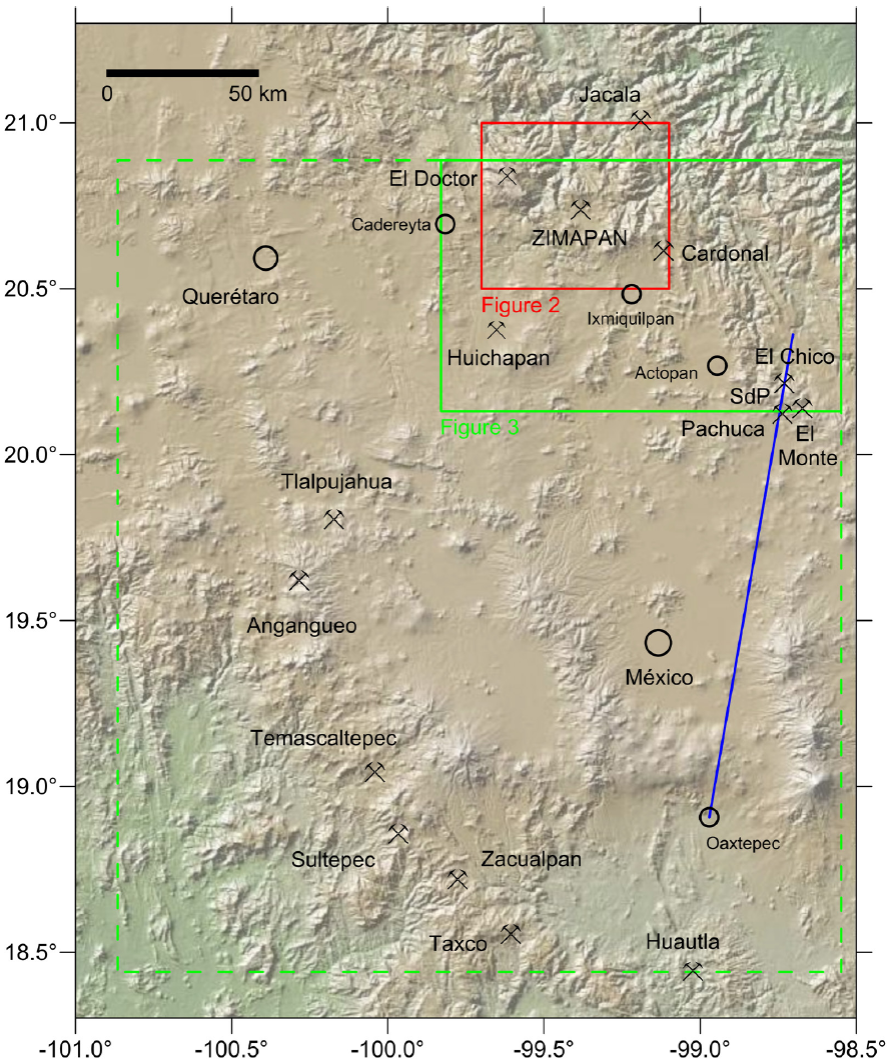
Figure 1
Shaded relief map of central Mexico, indicating the location of Zimapán and the approximate extent of the geologic map by von Gerolt and de Berghes (1827) (green dashed outline). Also indicated are the regions covered by Figure 2 (green solid outline) and Figure 3 (red outline). Also marked are major mining districts of the early 19th century and, in blue, the trace of the geologic section by von Humboldt (1834), constructed in 1803. SdP: Sierra de Pachuca.
Shaded relief map of central Mexico, indicating the location of Zimapán and the approximate extent of the geologic map by von Gerolt and de Berghes (1827) (green dashed outline). Also indicated are the regions covered by Figure 2 (green solid outline) and Figure 3 (red outline). Also marked are major mining districts of the early 19th century and, in blue, the trace of the geologic section by von Humboldt (1834), constructed in 1803. SdP: Sierra de Pachuca.
2. Early Colonial Mining
Silver has been mined in the Zimapán region since ~A.D. 1575 according to the Relación de las Minas de Cimapan (Acuña, 1985). This report, written in A.D. 1579 and preserved in the Archivo General de Indias in Seville, Spain (Gerhard, 1986), provides the response by the colonial government to a geographic questionnaire commissioned by the Spanish crown. Based on this Relación Geográfica, Zimapán was settled in A.D. 1575 by Spanish miners. Beside silver, the mines produced much margajita (marcasite, FeS2), caparrosa (copperas, FeSO4), and an overabundance of lead. The Relación de las Minas de Cimapanincludes a map (Acuña, 1985) that shows the toponyms "Minas del Monte", "Minas del Toliman", and "Minas de Santiago." Mines in the Sierra El Monte and in the Barranca de Tolimán (Figure 2), which are associated with monzonite intrusive bodies and dikes (Simons and Mapes, 1956), are still the principal metal production areas of the Zimapán mining district (Navarro-Barrera, 1982; García and Querol, 1991; Yta and Moreno-Tovar, 1997).
-
Acuña, 1985Relaciones Geográficas del Siglo XVI: México, 1985
-
Gerhard, 1986Geografía histórica de la Nueva España 1519-1821, 1986
-
Acuña, 1985Relaciones Geográficas del Siglo XVI: México, 1985
-
Simons and Mapes, 1956Geology and ore deposits of the Zimapán mining district, State of Hidalgo, Mexico, 1956
-
Navarro-Barrera, 1982Geología y operación minera del cuerpo Concordia NW, mina El Monte, distrito de Zimapán, Estado de HidalgoLibro-guía de la excursión geológica a la región de Zimapán y áreas circundantes, 1982
-
García and Querol, 1991Description of some deposits in the Zimapán district, HidalgoEconomic Geology of Mexico, 1991
-
Yta and Moreno-Tovar, 1997La mineralización en los distritos mineros Pachuca-Real del Monte y Zimapán-su papel en la evolución metalogénica del Estado de HidalgoII Convención sobre la Evolución Geológica de México, Pachuca, Hidalgo, Libro-guía de las excursiones geológicas, Excursión 3, 1997
Thumbnail
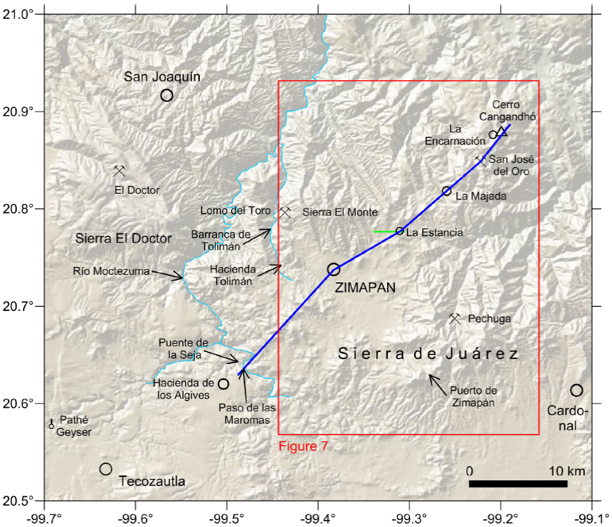
Figure 2
Outline map of the Zimapán area, indicating in blue the trace of the geologic section by Burkart (1836), reproduced in Figure 6. Red box: approximate extent of the geologic map by Galeotti (1838a), shown in Figure 7. Also indicated are several place names mentioned in the text.
Outline map of the Zimapán area, indicating in blue the trace of the geologic section by Burkart (1836), reproduced in Figure 6. Red box: approximate extent of the geologic map by Galeotti (1838a), shown in Figure 7. Also indicated are several place names mentioned in the text.
Since the Zimapán ore contains admixtures of lead-bearing minerals, the separation of silver from the base metal was done by smelting in a furnace rather than by the more efficient amalgamation with mercury. Some of the lead compounds were shipped to other mining camps such as Guanajuato and Pachuca, where they were used in the smelting process, whereas by demand of the Spanish Crown all silver was sent to Mexico City (Figure 1) for coinage at the royal mint (Brading, 1971 and references therein).
-
Brading, 1971Miners and merchants in Bourbon Mexico 1763-1810, 1971
3. Geologic Studies During the Colonial Period
The Real de Minas de Zimapán was visited in 1791 by the Comisión Científica Novohispana. This was a detached party by some members of the Malaspina expedition, a Spanish maritime naturalist journey. In the journal of his voyage, Alejandro Malaspina explicitly asked the Comisión Científica Novohispana, lead by naturalist Antonio Pineda y Ramírez, to focus its research on lithology (David et al., 2003). From late August 1791 on, this group of naturalists visited mining districts north of Mexico City, such as Pachuca and Guanajuato, for more than two months; a map of their itinerary can be found in González Claverán (1988, 1989). The expedition visited Zimapán in September of 1791, arriving from the lead mines at Real del Cardonal through Ixmiquilpan (Figure 1) and then moving on to Paso de las Maromas, Hacienda de los Algives and Santiago Tecozautla (Figure 2), from where they examined the nearby Pathé thermal baths (Engstrand, 1981; González Claverán, 1988). The travel diaries written by Antonio Pineda y Ramírez are conserved at the Archivo del Museo Naval, Madrid (manuscripts 562 and 563) and were partly transcribed by González Claverán (1988). Pineda notes that Ixmiquilpan is located in a scrubby terrain on limestone, and that he crossed near town gravel composed of limestone and porphyry pebbles with a red surface. He describes the ore smelting and refining process at Zimapán in detail and documents it with drawings. Pineda also visited the Santa Clara and San Vicente mines, located northwest of Zimapán, near the Barranca de Tolimán (Simons and Mapes, 1956), from where he reports that the dikes in the Santa Clara mine are oriented east-west and intruded in limestone and that the dikes at the portal of the San Vicente mine bifurcate.
-
David et al., 2003The Malaspina Expedition 1789-1794, Journal of the Voyage by Alejandro Malaspina, 2003
-
González Claverán (1988La expedición científica de Malaspina en Nueva España 1789-1794, 1988
-
1989)Malaspina en Acapulco, 1989
-
Engstrand, 1981Spanish scientists in the New World, The eighteenth-century expeditions, 1981
-
González Claverán, 1988La expedición científica de Malaspina en Nueva España 1789-1794, 1988
-
González Claverán (1988)La expedición científica de Malaspina en Nueva España 1789-1794, 1988
-
Simons and Mapes, 1956Geology and ore deposits of the Zimapán mining district, State of Hidalgo, Mexico, 1956
More importantly, the Zimapán Mining district attracted, in the very early 19th century, scholars from the Real Seminario de Minería (Quelle, 1937; Pferdekamp, 1938; Trabulse, 1994; Azuela, 2005, 2009; Ramos Lara, 2012), such as Andrés Manuel del Río (Amorós Portolés, 1985; Rubinóvich, 1992; Puche Riart and Ayala Carcedo, 1993; Trabulse, 1984, 1994 and references therein), Friedrich (Federico) Traugott Sonneschmid (Liesegang, 1949; von Mentz, 1982; Trabulse, 1984; Strulik, 1988 and references therein), and Alexander von Humboldt, who was a visiting scholar at the Real Seminario de Minería in 1803 - 1804 (Beck, 1958, 1966; Beck and Bonacker, 1969; Rubinóvich and Lozano, 1997; Leitner, 2000). All three of them were graduates of the Freiberg mining academy (Bergakademie Freiberg) in Saxony (Quelle, 1937; Strulik, 1988) and much-influenced by the teaching of Abraham Gottlob Werner. In Werner's account of earth history, which dominated geology until the 1820s, rocks were successively deposited in a primordial ocean as universal formations that could be recognized around the whole globe on the basis of lithology and superposition (Laudan, 1987). This theory is echoed by del Río (1803) in his "Discurso sobre las formaciones de las montañas de algunos Reales de minas", when he writes
-
Quelle, 1937Das "Colegio de Minería" in Mexiko unter deutschem wissenschaftlichen EinflussIbero-Amerikanisches Archiv, 1937
-
Pferdekamp, 1938Deutsche im frühen Mexiko, 1938
-
Trabulse, 1994Historia de la ciencia en México (versión abreviada), 1994
-
Azuela, 2005De las minas al laboratorio: La demarcación de la geología en la Escuela Nacional de Ingenieros (1795-1895): Geografía para el Siglo XXI, 2005
-
2009La geología en México en el siglo XIX: entre las aplicaciones prácticas y la investigación básicaRevista Geológica de América Central, 2009
-
Ramos Lara, 2012Intercambio de ideas científicas y técnicas en la formación de los ingenieros de minas mexicanos antes, durante y después de la IndependenciaAmérica Latina: La autonomía de una región, 2012
-
Amorós Portolés, 1985Andrés del Río y su obraElementos de Orictognosia o del conocimiento de los fósiles, dispuestos, según los principios de A.G. Werner, para el Uso del Real Seminario de Minería de México, 1795 & 1805, 19851985
-
Rubinóvich, 1992Andrés del Río y sus Elementos de Orictognosia de 1795-1805Elementos de Orictognosia o del conocimiento de los fósiles, dispuestos, según los principios de A.G. Werner, para el Uso del Real Seminario de Minería de México, 1795 & 1805, facsimile edition, 1992
-
Puche Riart and Ayala Carcedo, 1993La 'Orygthología' de Juan José Elhúyar (1754-1796) y la 'Orictognosia' de Andrés Manuel del Río (1764-1849), primeros tratados geológicos, escritos por españoles en AméricaBoletín Geológico y Minero, 1993
-
Trabulse, 1984Historia de la ciencia en México, quinta parte, apéndices e índices, 1984
-
1994Historia de la ciencia en México (versión abreviada), 1994
-
Liesegang, 1949Deutsche Berg- und Hüttenleute in Süd- und Mittel-Amerika, 1949
-
von Mentz, 1982México en el siglo XIX visto por los Alemanes, 1982
-
Trabulse, 1984Historia de la ciencia en México, quinta parte, apéndices e índices, 1984
-
Strulik, 1988Acerca do papel dos licenciados da Academia de Minas de Freiberg na história da indústria mineira e metalúrgica no México até o fim do século XIXO conhecimento geológico na América Latina: Questões de história e teoria, 1988
-
Beck, 1958Alexander von Humboldts "Essay de Pasigraphie", Mexico 1803/04Forschungen und Fortschritte, 1958
-
1966Alexander von Humboldt und Mexiko, 1966
-
Beck and Bonacker, 1969Atlas géographique et physique du royaume de la Nouvelle-Espagne. Vom Verfasser auch kurz benannt: Mexico-Atlas. Neudruck des 1811 in Paris erschienenen Werkes, vermehrt um die "Introduction geographique" des "Essai politique du royaume de la Nouvelle-Espagne", die jede Tafel des "Mexiko-Atlasses" erläutert, sowie um 7 Karten des "Atlas géographique et physique des régions équinoxiales du nouveau continent (Paris, 1814-l834) und eine Bildtafel aus den "Vues des Cordillères" (Paris, 1813) die Mexico betreffen, 1969
-
Rubinóvich and Lozano, 1997La aventura geológica de Humboldt en la Nueva España, in Alejandro de Humboldt en México, 1997
-
Leitner, 2000Humboldt's work on MexicoQuipu, 2000
-
Quelle, 1937Das "Colegio de Minería" in Mexiko unter deutschem wissenschaftlichen EinflussIbero-Amerikanisches Archiv, 1937
-
Strulik, 1988Acerca do papel dos licenciados da Academia de Minas de Freiberg na história da indústria mineira e metalúrgica no México até o fim do século XIXO conhecimento geológico na América Latina: Questões de história e teoria, 1988
-
Laudan, 1987From mineralogy to geology: the foundations of a science, 1650-1830, 1987
-
del Río (1803)Discurso sobre las formaciones de las montañas de algunos Reales de MinasGaceta de México, 1803
"...las montañas... están dispuestas y colocadas regularmente unas sobre otras, é estratificadas con mucho órden, y que la relacion de su estratificación, ó la sucesion de sus laxas y capas, lejos de estar circunscripta á cada punto de la superficie del globo, y ser diversa en cada parage, es al contrario idéntica, y se repite muchas veces en paises muy distantes unos de otros, y tan constantemente, que se puede determinar hasta su diversa antigüedad."
Based on the same concept, von Humboldt (1805) designs and correlates stratigraphic columns of the American and European continents in his Introducción a la pasigrafía geológica, which forms part of del Río's textbook "Elementos de Orictognosia" (del Río, 1805, 1985, 1992), and on which he eventually elaborates in his Geognostischer Versuch über die Lagerung der Gebirgsarten in beiden Erdhälften (Ensayo geognóstico sobre la superposición de las rocas en los dos hemisferios) (von Humboldt, 1823).
-
von Humboldt (1805)Introducción a la pasigrafía geológicaElementos de Orictognosia o del conocimiento de los fósiles dispuestos, según los principios de A.G. Werner, para el uso del Real Seminario de Minería de México, 1805
-
del Río, 1805Elementos de Orictognosia o del conocimiento de los fósiles, dispuestos, según los principios de A.G. Werner, para el Uso del Real Seminario de Minería de México, 1805
-
1985Elementos de Orictognosia o del conocimiento de los fósiles, dispuestos, según los principios de A.G. Werner, para el Uso del Real Seminario de Minería de México, 1795 & 1805, 1985
-
1992Elementos de Orictognosia o del conocimiento de los fósiles, dispuestos, según los principios de A.G. Werner, para el Uso del Real Seminario de Minería de México, 1795 & 1805, 1992
-
von Humboldt, 1823Geognostischer Versuch über die Lagerung der Gebirgsarten in beiden Erdhälften, 1823
What we now would call the geological sciences had, at that time, three major divisions: orictognosy, the identification and classification of minerals; geognosy, the formation and history of rocks and minerals; and mineral geography, the distribution of rocks and minerals both above and below ground (Laudan, 1992).
-
Laudan, 1992Book review: Andres Manuel del Río, Elementos de Orictognosia 1795-1805, facsimilar edition edited and introduced by R. Rubinóvich Kogan, Mexico City, Universidad Nacional Autónoma de México, Instituto de Geología, 1992Quipu, 1992
A textual description of some outcrops near Zimapán (along Barranca de Tolimán, in the Sierra El Monte region, and in the mountain range between Zimapán and Ixmiquilpan; Figure 2) is given by del Río (1803), based on quoted field observations by Sonneschmid and samples from the Seminario de Minería rock collection. Del Río, who is better known for his discovery of the element vanadium (Caswell, 2003) and his chemical analyses of minerals (e.g., del Río, 1835a; 1835b; Trabulse, 1984, 1994, and references therein), describes sediments such as fossil-bearing limestone with chert intercalations, greywacke, slate, shale, and marl, occasionally indicating their strike and dip. His description also includes several types of igneous rocks and their mineral composition, as well as economic mineral deposits and their locations. However, his study is difficult to verify or compare with more recent observations, since it does not include maps or sections. Del Río (1803) also compares the lithologies of the Zimapán region with those at other nearby mining centers such as Real del Doctor, Xacala, Real del Oro, Pechuga, or Real del Cardonal (Figures 1 and 2).
-
del Río (1803)Discurso sobre las formaciones de las montañas de algunos Reales de MinasGaceta de México, 1803
-
Caswell, 2003Andrés del Río, Alexander von Humboldt, and the twice-discovered elementBulletin for the History of Chemistry, 2003
-
Río, 1835aElementos de orictognosia o del conocimiento de los fósiles según el sistema de Bercelio, y según los principios de Abraham Gottlob Werner, con la sinonimia inglesa, alemana y francesa para el uso del Seminario Nacional de Minería de México, parte práctica, 1835
-
1835bDel ZimapanioRevista Mexicana, Periódico Científico y Literario, Ignacio Cumplido, 1835
-
Trabulse, 1984Historia de la ciencia en México, quinta parte, apéndices e índices, 1984
-
1994Historia de la ciencia en México (versión abreviada), 1994
-
Del Río (1803)Discurso sobre las formaciones de las montañas de algunos Reales de MinasGaceta de México, 1803
A note in del Río (1803), for which he gives credit to von Humboldt, is
-
del Río (1803)Discurso sobre las formaciones de las montañas de algunos Reales de MinasGaceta de México, 1803
"El rumbo y el echado de las laxas y capas no sigue de ningun modo como se creía la direccion ni el declive de las cordilleras."
His observation was probably puzzling to von Humboldt because in Werner's theory, inclined strata were deposited on the continental slope of an inactive earth. His way of reasoning is, at the same time, an early use of the principle of falsificationism (Cleland, 2001).
-
Cleland, 2001Historical science, experimental science, and the scientific methodGeology, 2001
A very similar but much more detailed account of the outcrops in the Zimapán region is given by Sonneschmid (1804), in his review of the minerals and rocks of the major mining districts in Mexico. This treatise was relied upon and credited in Alexander von Humboldt's work as well as that of Joseph Burkart (see below). However, contrary to von Humboldt's work, the book by Sonneschmid is virtually unknown (von Mentz, 1982); it has escaped attention in reviews of the history of geologic studies in Mexico (e.g., Aguilera, 1904; de Cserna, 1990). Sonneschmid stayed in Mexico for 12 years, where he was employed at the Real Seminario de Minería. He returned to Germany in 1800, before von Humboldt's visit. His report about the Zimapán region is based on 100 days of field work there, barometric readings, and assaying some of his samples with a blowpipe (for a discussion of this technique, see Newcomb, 2009). However, like del Río's 1803 account, the work by Sonneschmid (1804) is difficult to assess, not only because it is not supported by maps or sections, but also because of the geological complexity of that region (see maps in Simons and Mapes, 1956) and because of the now obsolete stratigraphic concept and names for rocks used by Sonneschmid. Del Río and Sonneschmid followed Werner's identification of the sequence of rocks, in which a "primitive class of rock formations" (predominantly granite and gneiss but also porphyry, slate, and sediments) is overlain by the "transition rocks" (mostly limestone and greywacke), followed in sequence by the "secondary class of rock formations" (such as sandstone, limestone, and gypsum) and alluvium (Laudan, 1987; Oldroyd, 2013).
-
Sonneschmid (1804)Mineralogische Beschreibung der vorzüglichsten Bergwerks-Reviere von Mexico oder Neuspanien, 1804
-
von Mentz, 1982México en el siglo XIX visto por los Alemanes, 1982
-
Aguilera, 1904Reseña del desarrollo de la geología en MéxicoBoletín de la Sociedad Geológica Mexicana, 1904
-
de Cserna, 1990La evolución de la geología en México (~1500-1929)Revista del Instituto de Geología, 1990
-
Newcomb, 2009The world in a crucible: laboratory practice and geological theory at the beginning of geology, 2009
-
del Río's 1803Discurso sobre las formaciones de las montañas de algunos Reales de MinasGaceta de México, 1803
-
Sonneschmid (1804)Mineralogische Beschreibung der vorzüglichsten Bergwerks-Reviere von Mexico oder Neuspanien, 1804
-
Simons and Mapes, 1956Geology and ore deposits of the Zimapán mining district, State of Hidalgo, Mexico, 1956
-
Laudan, 1987From mineralogy to geology: the foundations of a science, 1650-1830, 1987
-
Oldroyd, 2013Maps as pictures or diagrams: The early development of geological mapsRethinking the Fabric of Geology, 2013
The geology of the Zimapán region is also mentioned cursorily by von Humboldt (1811) in his Essai politique sur le royaume de la Nouvelle Espagne and in Geognostischer Versuch über die Lagerung der Gebirgsarten in beiden Erdhälften (Ensayo geognóstico sobre la superposición de las rocas en los dos hemisferios) (von Humboldt, 1823). Like del Río's (1803), Humboldt's work about the Zimapán region, which he did not visit, is based on Sonneschmid (1804).
-
von Humboldt (1811)Essai politique sur le royaume de la Nouvelle Espagne avec un atlas physique et géographique, 1811
-
von Humboldt, 1823Geognostischer Versuch über die Lagerung der Gebirgsarten in beiden Erdhälften, 1823
-
del Río's (1803)Discurso sobre las formaciones de las montañas de algunos Reales de MinasGaceta de México, 1803
-
Sonneschmid (1804)Mineralogische Beschreibung der vorzüglichsten Bergwerks-Reviere von Mexico oder Neuspanien, 1804
4. Geologic Studies after Mexico's Gain of Independence from Spain
In order to stimulate the debilitated economy in the aftermath of the revolutionary war, several mining corporations relying on British, German, and American capital investment and technology were formed after Mexico's gain of independence in 1821 (Kruse, 1923; Strulik, 1988). As a result, the published geologic information about the mining regions increased and included, for the first time, geologic maps and cross sections (von Gerolt and de Berghes, 1827; Burkart, 1836). In the Zimapán region, most mines were leased by the German-American Mining Corporation (Deutsch-Amerikanischer Bergwerksverein, Sociedad Minera Alemana-Americana) (Kruse, 1923; Pferdekamp, 1958). An exception was the Lomo del Toro lead mine (Figure 2), which was leased by the British Real del Monte Company (Randall, 1972). Thomas Coulter, a renowned Irish botanist, was in charge of the mine up to 1829 (Coville, 1895; Nelson, 1988). Unrelated to the mining companies, the Belgian naturalist Henri Guillaume Galeotti also did geologic field work in the Zimapán region during this time. In what follows, I document, in chronological order, the maps and cross sections of the Zimapán region published during this period by von Gerolt and de Berghes (1827), Burkart (1836), and Galeotti (1838a, 1838b).
-
Kruse, 1923Deutsche Briefe aus Mexiko mit einer Geschichte des Deutsch-Amerikanischen Bergwerksvereins 1824-1838Veröffentlichungen des Archivs für Rheinisch-Westfälische Wirtschaftsgeschichte, 1923
-
Strulik, 1988Acerca do papel dos licenciados da Academia de Minas de Freiberg na história da indústria mineira e metalúrgica no México até o fim do século XIXO conhecimento geológico na América Latina: Questões de história e teoria, 1988
-
von Gerolt and de Berghes, 1827Geognostische Karte der vorzüglichsten Bergwerks-Districte des Staates von Mexico: nach astronomischen, barometrischen und mineralogischen Beobachtungen, 1827
-
Burkart, 1836Aufenthalt und Reisen in Mexico in den Jahren 1825 bis 1834; Bemerkungen über Land, Produkte, Leben und Sitten der Einwohner und Beobachtungen aus dem Gebiete der Mineralogie, Geognosie, Bergbaukunde, Meteorologie, Geographie, 1836
-
Kruse, 1923Deutsche Briefe aus Mexiko mit einer Geschichte des Deutsch-Amerikanischen Bergwerksvereins 1824-1838Veröffentlichungen des Archivs für Rheinisch-Westfälische Wirtschaftsgeschichte, 1923
-
Pferdekamp, 1958Auf Humboldts Spuren, Deutsche im jungen Mexiko, 1958
-
Randall, 1972Real del Monte, a British mining venture in Mexico, 1972
-
Coville, 1895The botanical explorations of Thomas Coulter in Mexico and CaliforniaBotanical Gazette, 1895
-
Nelson, 1988Trinity's miner-botanist Dr. Thomas Coulter (1793-1843)Hermathena, 1988
-
von Gerolt and de Berghes (1827)Geognostische Karte der vorzüglichsten Bergwerks-Districte des Staates von Mexico: nach astronomischen, barometrischen und mineralogischen Beobachtungen, 1827
-
Burkart (1836)Aufenthalt und Reisen in Mexico in den Jahren 1825 bis 1834; Bemerkungen über Land, Produkte, Leben und Sitten der Einwohner und Beobachtungen aus dem Gebiete der Mineralogie, Geognosie, Bergbaukunde, Meteorologie, Geographie, 1836
-
Galeotti (1838aCarte géognostique des environs de Zimapan au MéxiqueBulletins de l'Académie Royale des Sciences et des Belles-Lettres de Bruxelles, 1838
-
1838bNotice géologique sur les environs de San José del OroBulletins de l'Académie Royale des Sciences et des Belles-Lettres de Bruxelles, 1838
4.1. The Map and Sections by von Gerolt and de Berghes
The earliest geologic map and sections of central Mexico, including the Zimapán region, were published in 1827 by Friedrich Karl Joseph von Gerolt and Carlos de Berghes, who were employed by the German-Mexican Mining Corporation and, like the scholars of the Real Seminario de Minería, were graduates of the Bergakademie Freiberg in Saxony (Kruse, 1923; Liesegang, 1949; Pferdekamp, 1958). This is the earliest published geologic map of any region in Mexico and among the earliest known regional geologic maps in Mexico after the 1803 geologic-topographic map of the Guanajuato area by Alexander von Humboldt (published in 1834; facsimile in Beck and Bonacker, 1969) and the 1826 geologic map, with five lithologic units, of the San Francisco (Alta California) Bay area by Edward Belcher, published in 1839 (Beidleman, 2006; Norris and Webb, 1990). The map by von Gerolt and de Berghes (1827) is practically unknown today; like the 1803 map of the Guanajuato area by Alexander von Humboldt, it has mostly escaped attention in reviews of early geologic maps (e.g., Oldroyd, 2013).
-
Kruse, 1923Deutsche Briefe aus Mexiko mit einer Geschichte des Deutsch-Amerikanischen Bergwerksvereins 1824-1838Veröffentlichungen des Archivs für Rheinisch-Westfälische Wirtschaftsgeschichte, 1923
-
Liesegang, 1949Deutsche Berg- und Hüttenleute in Süd- und Mittel-Amerika, 1949
-
Pferdekamp, 1958Auf Humboldts Spuren, Deutsche im jungen Mexiko, 1958
-
von Humboldt (published in 1834Atlas géographique et physique des régions équinoxiales du Nouveau Continent, 1834
-
Beck and Bonacker, 1969)Atlas géographique et physique du royaume de la Nouvelle-Espagne. Vom Verfasser auch kurz benannt: Mexico-Atlas. Neudruck des 1811 in Paris erschienenen Werkes, vermehrt um die "Introduction geographique" des "Essai politique du royaume de la Nouvelle-Espagne", die jede Tafel des "Mexiko-Atlasses" erläutert, sowie um 7 Karten des "Atlas géographique et physique des régions équinoxiales du nouveau continent (Paris, 1814-l834) und eine Bildtafel aus den "Vues des Cordillères" (Paris, 1813) die Mexico betreffen, 1969
-
Beidleman, 2006California's frontier naturalists, 2006
-
Norris and Webb, 1990Geology of California, 1990
-
von Gerolt and de Berghes (1827)Geognostische Karte der vorzüglichsten Bergwerks-Districte des Staates von Mexico: nach astronomischen, barometrischen und mineralogischen Beobachtungen, 1827
-
Oldroyd, 2013Maps as pictures or diagrams: The early development of geological mapsRethinking the Fabric of Geology, 2013
With the meridian of Mexico City as its origin, the map extends from 1° E to 1.5° W longitude of Mexico City and from about 18.4° to 21° N latitude (Figure 1). It builds on the previous topographic maps of central Mexico by Alexander von Humboldt (1811) (Beck and Bonacker, 1969), which were locally based on a detailed unpublished map of the region between Real del Doctor and Zimapán by Manuel Mascaró.
-
Alexander von Humboldt (1811)Essai politique sur le royaume de la Nouvelle Espagne avec un atlas physique et géographique, 1811
-
Beck and Bonacker, 1969Atlas géographique et physique du royaume de la Nouvelle-Espagne. Vom Verfasser auch kurz benannt: Mexico-Atlas. Neudruck des 1811 in Paris erschienenen Werkes, vermehrt um die "Introduction geographique" des "Essai politique du royaume de la Nouvelle-Espagne", die jede Tafel des "Mexiko-Atlasses" erläutert, sowie um 7 Karten des "Atlas géographique et physique des régions équinoxiales du nouveau continent (Paris, 1814-l834) und eine Bildtafel aus den "Vues des Cordillères" (Paris, 1813) die Mexico betreffen, 1969
The map covers the mining districts worked by the German-American Mining Corporation (Figure 1): El Chico in the east; San José del Oro and Zimapán in the north; Tlalpujahua and Angangueo in the west; and Temascaltepec and Sultepec in the southwest. In the south, the map reaches until the mining district of Huautla.
The map went through several editions. The original edition was published in German (von Gerolt and de Berghes, 1827). It included a topographic map sheet, a sheet with the geology overlain on the same base map, four sheets with profiles, and an explanatory pamphlet that mostly refers to ore deposits. Detailed contemporary reviews were provided by Nöggerath (1828) and Berghaus (1828). A second edition was published in French in 1828 (von Gerolt and de Berghes, 1828). A third edition appeared in English in 1864 (von Gerolt and de Berghes, 1864). It was edited by Friedrich Wilhelm von Egloffstein, a prominent German-American cartographer, who had participated in the Frémont, Gunnison, and Ives western expeditions (Rowan, 2012). Von Egloffstein arranged the map and 11 sections on one single plate, using a scale 1:760320 or 12 miles to the inch. The map looks very modern. Whereas Alexander von Humboldt had used hachures to indicate the topographic relief, von Egloffstein uses shading, with the source of light being located in the northwest. He also uses a new half-tone printing process that he invented and patented (Rowan, 2012).
-
von Gerolt and de Berghes, 1827Geognostische Karte der vorzüglichsten Bergwerks-Districte des Staates von Mexico: nach astronomischen, barometrischen und mineralogischen Beobachtungen, 1827
-
Nöggerath (1828)Literarische Anzeige, Carta geognostica de los principales distritos minerales del Estado de Mexico etc., hechas por Federico de Gerolt y Carlos de BerghesJournal für Chemie und Physik, 1828
-
Berghaus (1828)Carta geognostica de los principales distritos minerales del estado de Mejiko, formadas sobre observaciones astronomicas, barometricas y mineralogicas, hechas por Federico de Gerolt y Carlos de Berghes. Anno de 1827Hertha, Zeitschrift für Erd-, Völker- und Staatenkunde, 1828
-
von Gerolt and de Berghes, 1828Carte géognostique des principaux districts de mines de l'état de Mexico: dressée d'après des observations astronomiques, barométriques et minéralogiques par Frédéric de Gerolt et Charles de Berghes, formant une carte de deux planches et dix coupes géognostiques en quatre planches, 1828
-
von Gerolt and de Berghes, 1864Contributions to the geology and the physical geography of Mexico including a geological and topographical map with profiles of some of the principle mining districts, 1864
-
Rowan, 2012The Baron in the Grand Canyon: Friedrich Wilhelm von Egloffstein in the West, 2012
-
Rowan, 2012The Baron in the Grand Canyon: Friedrich Wilhelm von Egloffstein in the West, 2012
An excerpt from the map covering the Zimapán area (Figure 3) and two cross sections passing through Zimapán (Figures 4 and 5) are reproduced here from the von Egloffstein edition. The map uses five lithologic units. Like del Río and Sonneschmid twenty-five years before them, von Gerolt and de Berghes follow Werner's concepts in their identification of the sequence of rocks in central Mexico. Furthermore, their work is likely to have been guided by von Humboldt (1823), who verbally describes a section across the trans-Mexican volcanic belt between Huastepec (now Oaxtepec) in the south and the Sierra de Pachuca in the north (trace on Figure 1). According to Beck and Bonacker (1969), this is the earliest geologic section of a region outside Europe. It was constructed by von Humboldt in 1803, during his stay in Mexico, but only published in 1834, in his Atlas géographique et physique des régions équinoxiales du Nouveau Continent(von Humboldt, 1834, 2009; facsimile in Beck and Bonacker, 1969).
-
von Humboldt (1823)Geognostischer Versuch über die Lagerung der Gebirgsarten in beiden Erdhälften, 1823
-
Beck and Bonacker (1969)Atlas géographique et physique du royaume de la Nouvelle-Espagne. Vom Verfasser auch kurz benannt: Mexico-Atlas. Neudruck des 1811 in Paris erschienenen Werkes, vermehrt um die "Introduction geographique" des "Essai politique du royaume de la Nouvelle-Espagne", die jede Tafel des "Mexiko-Atlasses" erläutert, sowie um 7 Karten des "Atlas géographique et physique des régions équinoxiales du nouveau continent (Paris, 1814-l834) und eine Bildtafel aus den "Vues des Cordillères" (Paris, 1813) die Mexico betreffen, 1969
-
von Humboldt, 1834Atlas géographique et physique des régions équinoxiales du Nouveau Continent, 1834
-
2009Geographischer und physischer Atlas der Äquinoktial-Gegenden des neuen Kontinents, 2009
-
Beck and Bonacker, 1969Atlas géographique et physique du royaume de la Nouvelle-Espagne. Vom Verfasser auch kurz benannt: Mexico-Atlas. Neudruck des 1811 in Paris erschienenen Werkes, vermehrt um die "Introduction geographique" des "Essai politique du royaume de la Nouvelle-Espagne", die jede Tafel des "Mexiko-Atlasses" erläutert, sowie um 7 Karten des "Atlas géographique et physique des régions équinoxiales du nouveau continent (Paris, 1814-l834) und eine Bildtafel aus den "Vues des Cordillères" (Paris, 1813) die Mexico betreffen, 1969
Thumbnail
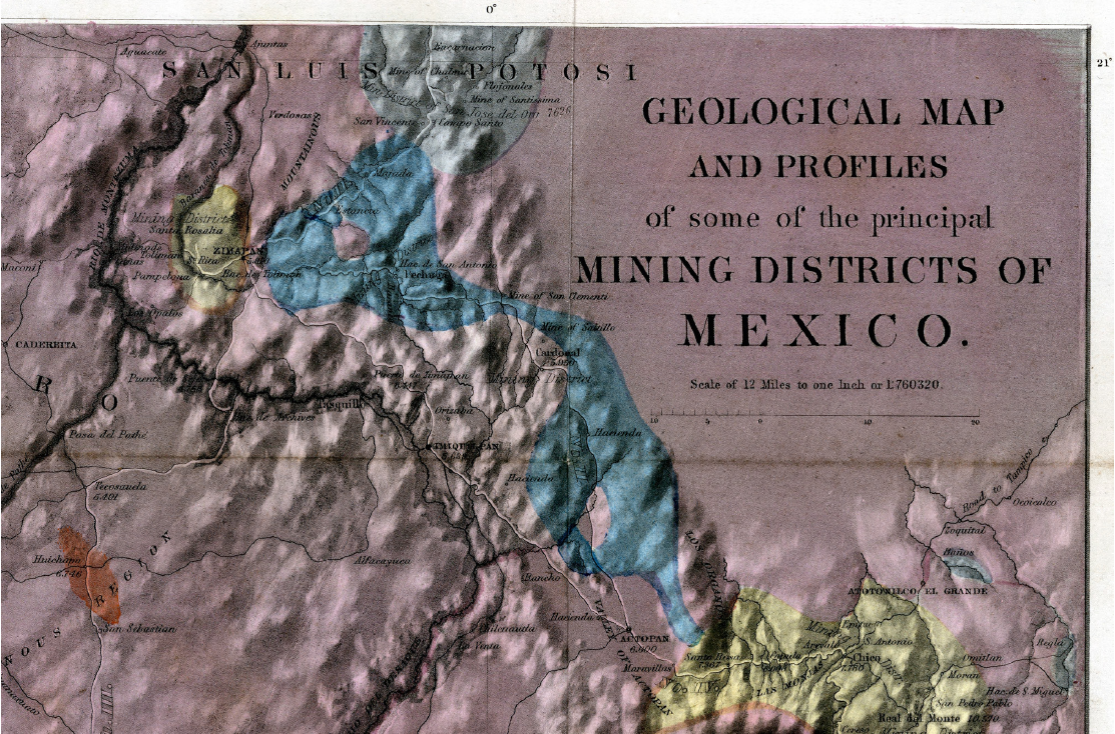
Figure 3
Excerpt of the 1827 geognostic map of central Mexico by von Gerolt and de Berghes (1864 edition), covering the Zimapán region.
Excerpt of the 1827 geognostic map of central Mexico by von Gerolt and de Berghes (1864 edition), covering the Zimapán region.
Thumbnail
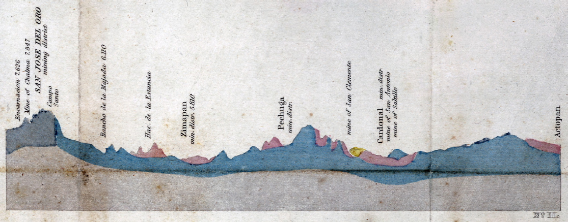
Figure 4
N-S geologic section from La Encarnación through Zimapán to Actopan by von Gerolt and de Berghes (1827), from the 1864 edition (profile II). The section trace, which is not a straight line, is indicated on Figure 3 by a partly white, partly black line, marked No. II. The topographic base of the sections is at 3000 feet. The vertical exaggeration is 15x.
N-S geologic section from La Encarnación through Zimapán to Actopan by von Gerolt and de Berghes (1827), from the 1864 edition (profile II). The section trace, which is not a straight line, is indicated on Figure 3 by a partly white, partly black line, marked No. II. The topographic base of the sections is at 3000 feet. The vertical exaggeration is 15x.
Thumbnail
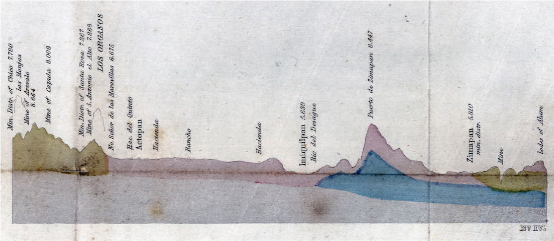
Figure 5
SE-NW geologic section from El Chico (Figure 1) through Actopan to Zimapán by von Gerolt and de Berghes (1827), from the 1864 edition (profile IV). The section trace is indicated on Figure 3 by a white line, marked No. IV. The topographic base of the sections is at 3000 feet. The vertical exaggeration is 15x.
SE-NW geologic section from El Chico (Figure 1) through Actopan to Zimapán by von Gerolt and de Berghes (1827), from the 1864 edition (profile IV). The section trace is indicated on Figure 3 by a white line, marked No. IV. The topographic base of the sections is at 3000 feet. The vertical exaggeration is 15x.
The oldest map unit, colored in grey, is termed "primitive limestone and syenite". In the Zimapán region (Figures 3 and 4), this unit covers the area south of La Encarnación, including the San José del Oro mining district with the Chalma and Santísima Trinidad gold mines. In our present understanding, these are Eocene dioritic stocks (Kiyokawa, 1982) and limestone of the Cretaceous El Abra Formation (Suter et al., 1997, fig. 2).
-
Kiyokawa, 1982Geological survey of the Pachuca-Zimapán area, central Mexico, phase III, 1982
-
Suter et al., 1997Structure of the Sierra Madre Oriental fold-thrust belt in east-central MexicoII Convención sobre la Evolución Geológica de México, Pachuca, Hidalgo, Libro-guía de las excursiones geológicas, Excursión 2, 1997
The second map unit from the base, colored in blue, is termed "Silurian Slate Formation (metalliferous)." According to von Gerolt and de Berghes (1827), this unit forms the basement of much of central Mexico, including the mining districts of Tlalpujahua, Temascaltepec, and Sultepec (Figure 2). On their map, this slate unit covers the area east of Zimapán, where they describe it as calcareous and siliceous slate, as well as the area north and east of Cardonal, where they describe it as calcareous slate with limestone (Figures 3 and 4). East of Zimapán, it corresponds, in our present understanding, to the Upper Jurassic-Lower Cretaceous Las Trancas Formation as well as the Upper Cretaceous Soyatal and Méndez Formations (Suter et al., 1997, fig. 2). Whereas the contact between their limestone-syenite and slate units is vertical on their profile (Figure 4), von Gerolt and de Berghes (1827) report that at Camposanto (Figure 3) the slate unit rests horizontally upon the limestone-syenite unit.
-
von Gerolt and de Berghes (1827)Geognostische Karte der vorzüglichsten Bergwerks-Districte des Staates von Mexico: nach astronomischen, barometrischen und mineralogischen Beobachtungen, 1827
-
Suter et al., 1997Structure of the Sierra Madre Oriental fold-thrust belt in east-central MexicoII Convención sobre la Evolución Geológica de México, Pachuca, Hidalgo, Libro-guía de las excursiones geológicas, Excursión 2, 1997
-
von Gerolt and de Berghes (1827)Geognostische Karte der vorzüglichsten Bergwerks-Districte des Staates von Mexico: nach astronomischen, barometrischen und mineralogischen Beobachtungen, 1827
Upsection follow the map unit termed "Metalliferous Porphyries," colored in yellow, and an equivalent unit of non-metalliferous volcanic rocks, colored in purple, which covers most of the map. According to von Gerolt and de Berghes (1827), these units are located everywhere upsection of the slate unit (Figures 4 and 5), specifically north of Zimapán, in the Barranca de Tolimán (Figure 4) and in the valley of the Moctezuma River, at Puente de la Seja (Figures 2 and 3; built in 1800 and now flooded by the reservoir of the Presa Hidráulica Zimapán). However, these outcrops are omitted from the map, possibly because of their small size. Neither do von Gerolt and de Berghes (1827) include the observations by Sonneschmid (1804) of limestone covering the Sierra El Doctor, west of the Moctezuma River (Figure 2), and the Sierra El Monte north of Zimapán, which they map as belonging to this volcanic unit. On the other hand, like del Río (1803) and Sonneschmid (1804) before them, they describe the high mountain range (with peak elevations > 3000 m above sea level), located southeast of Zimapán (Figure 3), now known as Sierra de Juárez (Figure 2), as being composed of volcanic rocks. In our present understanding, the rocks of these two map units partly belong to the silicic volcanic province of the Sierra Madre Occidental and partly to the trans-Mexican volcanic belt. The volcanic rocks of the Sierra de Juárez, mapped as Pachuca Group by Segerstrom (1962), belong to the former; the Pachuca Group has K-Ar ages between 25 and 27 Ma in the Sierra de Juárez (Kiyokawa, 1982) and ≥ 21 Ma in the Sierra de Pachuca (Figure 1; Dreier, 2005).
-
von Gerolt and de Berghes (1827)Geognostische Karte der vorzüglichsten Bergwerks-Districte des Staates von Mexico: nach astronomischen, barometrischen und mineralogischen Beobachtungen, 1827
-
von Gerolt and de Berghes (1827)Geognostische Karte der vorzüglichsten Bergwerks-Districte des Staates von Mexico: nach astronomischen, barometrischen und mineralogischen Beobachtungen, 1827
-
Sonneschmid (1804Mineralogische Beschreibung der vorzüglichsten Bergwerks-Reviere von Mexico oder Neuspanien, 1804
-
del Río (1803)Discurso sobre las formaciones de las montañas de algunos Reales de MinasGaceta de México, 1803
-
Segerstrom (1962)Geology of south-central Hidalgo and northeastern México, MexicoU.S. Geological Survey Bulletin, 1962
-
Kiyokawa, 1982Geological survey of the Pachuca-Zimapán area, central Mexico, phase III, 1982
-
Dreier, 2005The environment of vein formation and ore deposition in the Purisima-Colon vein system, Pachuca Real del Monte district, Hidalgo, MexicoEconomic Geology, 2005
The youngest unit on the map by von Gerolt and de Berghes (1827), colored in red, are young volcanoes and their deposits, such as Nevado de Toluca, Popocatépetl, and Iztaccíhuatl. The Huichapan region is included in this unit (Figures 1 and 3), and from there they report extensive deposits of pumice, extracted by subterraneous mining. In our present understanding, these pumice deposits have a 4.2 Ma age and form part of the Donguinyó-Huichapan caldera complex (Aguirre-Díaz and López-Martínez, 2009).
-
von Gerolt and de Berghes (1827)Geognostische Karte der vorzüglichsten Bergwerks-Districte des Staates von Mexico: nach astronomischen, barometrischen und mineralogischen Beobachtungen, 1827
-
Aguirre-Díaz and López-Martínez, 2009Geologic evolution of the Donguinyó-Huichapan caldera complex, central Mexican Volcanic Belt, MexicoJournal of Volcanology and Geothermal Research, 2009
4.2. The Cross Section by Hermann Joseph Burkart
Hermann Joseph Burkart was the technical director of the British Tlalpujahua Company 1825-1828 and occupied the same position in the British Bolaños Company 1828-1834, for which he worked in Zacatecas (Pferdekamp, 1958). In the time between these two assignments, Burkart visited the mining districts in central Mexico, including Zimapán. After his return to Germany, he published a book about the geology of central Mexico (Burkart, 1836). According to von Mentz (1982), Burkart tried to emulate von Humboldt, to whom he dedicated his work. The book includes a geologic map of the Zacatecas region. Previously, Burkart (1832) had already published the earliest geologic map and cross sections of a part of Michoacán State.
-
Pferdekamp, 1958Auf Humboldts Spuren, Deutsche im jungen Mexiko, 1958
-
Burkart, 1836Aufenthalt und Reisen in Mexico in den Jahren 1825 bis 1834; Bemerkungen über Land, Produkte, Leben und Sitten der Einwohner und Beobachtungen aus dem Gebiete der Mineralogie, Geognosie, Bergbaukunde, Meteorologie, Geographie, 1836
-
von Mentz (1982)México en el siglo XIX visto por los Alemanes, 1982
-
Burkart (1832)Geognostische Bemerkungen, gesammelt auf einer Reise von Tlalpujahua nach Huetamo, dem Jorullo, Patzcuaro und Valladolid, im Staate von MichoacanKarsten's Archiv für Mineralogie, Geognosie, Bergbau und Hüttenkunde, 1832
Burkart visited Zimapán in 1828. Like the Comisión Científica Novohispana in 1791, he approached Zimapán from Ixmiquilpan and left by way of Paso de las Maromas (located somewhat upstream of Puente de la Seja, Figure 2) to Tecozautla, Pathé, and Cadereyta (Figures 1 and 2). Burkart (1836, plate V) provides a very detailed cross section of the Zimapán area, which is based on his geological excursions. It is among the earliest published geologic cross sections of a region in Mexico after the sections by von Gerolt and de Berghes (1827, Figures 4 and 5), the Michoacán sections by Burkart (1832) mentioned above, and the cross section of the trans-Mexican volcanic belt drafted by Alexander von Humboldt in 1803 but only published in 1834, shortly before Burkart's book (von Humboldt, 1834, 2009; Beck and Bonacker, 1969).
-
Burkart (1836, plate V)Aufenthalt und Reisen in Mexico in den Jahren 1825 bis 1834; Bemerkungen über Land, Produkte, Leben und Sitten der Einwohner und Beobachtungen aus dem Gebiete der Mineralogie, Geognosie, Bergbaukunde, Meteorologie, Geographie, 1836
-
von Gerolt and de Berghes (1827Geognostische Karte der vorzüglichsten Bergwerks-Districte des Staates von Mexico: nach astronomischen, barometrischen und mineralogischen Beobachtungen, 1827
-
Burkart (1832)Geognostische Bemerkungen, gesammelt auf einer Reise von Tlalpujahua nach Huetamo, dem Jorullo, Patzcuaro und Valladolid, im Staate von MichoacanKarsten's Archiv für Mineralogie, Geognosie, Bergbau und Hüttenkunde, 1832
-
von Humboldt, 1834Atlas géographique et physique des régions équinoxiales du Nouveau Continent, 1834
-
2009Geographischer und physischer Atlas der Äquinoktial-Gegenden des neuen Kontinents, 2009
-
Beck and Bonacker, 1969Atlas géographique et physique du royaume de la Nouvelle-Espagne. Vom Verfasser auch kurz benannt: Mexico-Atlas. Neudruck des 1811 in Paris erschienenen Werkes, vermehrt um die "Introduction geographique" des "Essai politique du royaume de la Nouvelle-Espagne", die jede Tafel des "Mexiko-Atlasses" erläutert, sowie um 7 Karten des "Atlas géographique et physique des régions équinoxiales du nouveau continent (Paris, 1814-l834) und eine Bildtafel aus den "Vues des Cordillères" (Paris, 1813) die Mexico betreffen, 1969
Burkart (1836) provides a detailed description of the geology along the trail from Ixmiquilpan to Zimapán, which at that time passed the Sierra de Juárez mountain range at Puerto de Zimapán (Figures 2 and 3), approximately 5 km east of the present Highway 85. From the Ixmiquilpan region and the lower part of the ascent to Puerto de Zimapán, he reports limestone and fine-grained sandstone with some intercalated conglomerate layers, which in our present understanding are part of the Pliocene-Pleistocene Tarango Formation (Segerstrom, 1962; Kowallis et al., 1998). Higher up the trail, he describes dense, thin-layered limestone with thin chert intercalations, which he calls "Bergkalk". In our present understanding, this limestone belongs to the Tamaulipas Formation and is located in the western flank of the Bonanza anticline (Suter et al., 1997, fig. 1). The higher part of the mountain range, near Puerto de Zimapán, he describes as a hornblende-bearing feldspar-porphyry.
-
Burkart (1836)Aufenthalt und Reisen in Mexico in den Jahren 1825 bis 1834; Bemerkungen über Land, Produkte, Leben und Sitten der Einwohner und Beobachtungen aus dem Gebiete der Mineralogie, Geognosie, Bergbaukunde, Meteorologie, Geographie, 1836
-
Segerstrom, 1962Geology of south-central Hidalgo and northeastern México, MexicoU.S. Geological Survey Bulletin, 1962
-
Kowallis et al., 1998Fission-track and single crystal 40Ar/39Ar laser fusion ages from volcanic ash layers in fossil-bearing Pliocene sediments in central MexicoRevista Mexicana de Ciencias Geológicas, 1998
-
Suter et al., 1997Structure of the Sierra Madre Oriental fold-thrust belt in east-central MexicoII Convención sobre la Evolución Geológica de México, Pachuca, Hidalgo, Libro-guía de las excursiones geológicas, Excursión 2, 1997
Burkart's (1836) major section of the Zimapán - La Encarnación region, here reproduced as Figure 6, extends from the Moctezuma River in the southwest to Cerro Cangandhó in the northeast, passing through Zimapán, Estancia, and San José del Oro. The approximate trace is marked on Figure 2. The legend indicates that the length scale of the section is amplified three times with respect to the length scale of the related map, which, however, Burkart did not include. The profile (Figure 6) shows much stratigraphic and structural detail, which he describes in the text. In the southwest, trachyte prorphyry overlies slate on either side of the Moctezuma River canyon. In our present understanding, these are volcanic rocks of the Las Espinas Formation overlying sediments of the Upper Cretaceous Soyatal Formation (Carrillo-Martínez, 2000). Towards the northeast, the section indicates porphyritic dikes intruded in slate near San Antonio, followed by a stock in the Tolimán River valley, and a red conglomerate overlying folded slate and limestone with an erosional unconformity near Zimapán (Figure 6). This configuration is comparable to the ones on the map by Carrillo-Martínez (2000) and on the locally more detailed map by Simons and Mapes (1956), who were apparently both unaware of the work by Burkart (1836). The red conglomerate is now known as the El Morro Formation (Carrasco-Velázquez et al., 2009 and references therein). Burkart infers the red conglomerate to be older than the many dikes by which it is intruded. The age of these dikes remains unstudied. The El Morro Formation has to be older than the Las Espinas volcanic rocks, which overlie conformably the El Morro Formation and interfinger with it locally (Simons and Mapes, 1956). Rocks of the Las Espinas Formation yielded a K-Ar age of 16 Ma near Puerto de la Estancia, close to their contact with the El Morro Formation (Suter et al., 1997, fig. 2).
-
Burkart's (1836)Aufenthalt und Reisen in Mexico in den Jahren 1825 bis 1834; Bemerkungen über Land, Produkte, Leben und Sitten der Einwohner und Beobachtungen aus dem Gebiete der Mineralogie, Geognosie, Bergbaukunde, Meteorologie, Geographie, 1836
-
Carrillo-Martínez, 2000Geología de la Hoja 14Q-e(7) Zimapán, Estados de Hidalgo y Querétaro, 2000
-
Carrillo-Martínez (2000)Geología de la Hoja 14Q-e(7) Zimapán, Estados de Hidalgo y Querétaro, 2000
-
Simons and Mapes (1956)Geology and ore deposits of the Zimapán mining district, State of Hidalgo, Mexico, 1956
-
Burkart (1836)Aufenthalt und Reisen in Mexico in den Jahren 1825 bis 1834; Bemerkungen über Land, Produkte, Leben und Sitten der Einwohner und Beobachtungen aus dem Gebiete der Mineralogie, Geognosie, Bergbaukunde, Meteorologie, Geographie, 1836
-
Carrasco-Velázquez et al., 2009Estratigrafía de la Formación El Morro del Paleoceno-Eoceno en Zimapán, HidalgoBoletín de la Sociedad Geológica Mexicana, 2009
-
Suter et al., 1997Structure of the Sierra Madre Oriental fold-thrust belt in east-central MexicoII Convención sobre la Evolución Geológica de México, Pachuca, Hidalgo, Libro-guía de las excursiones geológicas, Excursión 2, 1997
Thumbnail
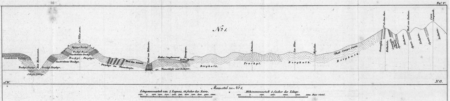
Figure 6
Geologic cross section between Zimapán and Cerro Cangandhó (La Encarnación) by Burkart (1836). The approximate trace of the section is marked on Figure 2 in blue.
Geologic cross section between Zimapán and Cerro Cangandhó (La Encarnación) by Burkart (1836). The approximate trace of the section is marked on Figure 2 in blue.
Farther northeast, between Zimapán and Cerro de San José, the section by Burkart (1836) passes within folded "Bergkalk" and locally at La Estancia in trachyte (Figure 6). What Burkart mapped as "Bergkalk" belongs, in our present understanding, to the Lower Cretaceous Tamaulipas and El Abra Formations and the Upper Jurassic-Lower Cretaceous Las Trancas Formation, whereas the trachyte near La Estancia is now part of the Miocene Las Espinas Formation (Suter et al., 1997). Between Cerro de San José and Cerro Cangandhó, Burkart's section indicates massive limestone intruded by several major dikes of garnet-bearing syenite (Figure 6). In our present understanding, these are two Eocene stocks intruded into limestone of the El Abra Formation, which forms several roof pendants (Suter et al., 1997, fig. 2).
-
Burkart (1836)Aufenthalt und Reisen in Mexico in den Jahren 1825 bis 1834; Bemerkungen über Land, Produkte, Leben und Sitten der Einwohner und Beobachtungen aus dem Gebiete der Mineralogie, Geognosie, Bergbaukunde, Meteorologie, Geographie, 1836
-
Suter et al., 1997Structure of the Sierra Madre Oriental fold-thrust belt in east-central MexicoII Convención sobre la Evolución Geológica de México, Pachuca, Hidalgo, Libro-guía de las excursiones geológicas, Excursión 2, 1997
-
Suter et al., 1997Structure of the Sierra Madre Oriental fold-thrust belt in east-central MexicoII Convención sobre la Evolución Geológica de México, Pachuca, Hidalgo, Libro-guía de las excursiones geológicas, Excursión 2, 1997
After leaving Zimapán, Burkart (1836) passed the El Pathé geyser (Figures 2 and 3), where he measured a temperature of 96 °C and observed an east-west alignment of nine springs on either side of the San Juan River valley. In our present understanding, these springs line up along an active fault of the Aljibes half-graben (Carrillo-Martínez, 1998, 2000).
-
Burkart (1836)Aufenthalt und Reisen in Mexico in den Jahren 1825 bis 1834; Bemerkungen über Land, Produkte, Leben und Sitten der Einwohner und Beobachtungen aus dem Gebiete der Mineralogie, Geognosie, Bergbaukunde, Meteorologie, Geographie, 1836
-
Carrillo-Martínez, 1998Normal faulting in the Pathé geothermal area, central MexicoGeofísica Internacional, 1998
-
2000Geología de la Hoja 14Q-e(7) Zimapán, Estados de Hidalgo y Querétaro, 2000
4.3. The Contributions by Henri Guillaume Galeotti
Galeotti did field work in Mexico 1835-1840, sponsored by the Etablissement géographique Vandermaelen in Brussels, of which he was a graduate (Lasègue, 1845, p. 209-211; Quetelet, 1859). Contrary to the researchers studying the Zimapán area before him, who all had a background in mining, Galeotti had a wide range of interests in natural history, but is mostly remembered for his botanical studies (McVaugh, 1978; Diagre, 2004). His geological notes from Mexico cover earthquakes (Galeotti, 1841); the biostratigraphy of invertebrates (Nyst and Galeotti, 1840) including Cretaceous foraminifers (Galeotti, 1839a); ore deposits (Galeotti, 1838c, 1838d); and geological maps and profiles from the Lake Chapala (Galeotti, 1839b) and Zimapán (Galeotti, 1838a, 1838b) regions. His biostratigraphic studies are the earliest ones in Mexico (Alencaster Ybarra, 2013). Galeotti (1839b) seems prescient when he cursorily mentions the existence of active faults in the Lake Chapala region:
-
Lasègue, 1845Musée botanique de M. Benjamin Delessert, Notices sur les collections de plantes et la bibliothèque qui le composent; contenant en outre des documents sur les principaux herbiers d'Europe et l'exposé des voyages entrepris dans l'intérêt de la botanique, 1845
-
Quetelet, 1859Notice sur Henri-Guillaume Galeotti, correspondant de l'AcadémieAnnuaire de l'Académie royale des Sciences, des Lettres et des Beaux-Arts de Belgique, 1859
-
McVaugh, 1978Galeotti's botanical work in Mexico: the numbering of his collections and a brief itineraryContributions from the University of Michigan Herbarium, 1978
-
Diagre, 2004Michel Scheidweiler y Henri Galeotti, los padres del género Ariocarpus(Cactaceae), 2004
-
Galeotti, 1841Sur les tremblements de terre et les étoiles filantesBulletin de l'Académie Royale des Sciences et des Belles-Lettres de Bruxelles, 1841
-
Nyst and Galeotti, 1840Sur quelques fossiles du calcaire jurassique de Tehuacan, au MexiqueBulletin de l'Académie Royale des Sciences et Belles-Lettres de Bruxelles, 1840
-
Galeotti, 1839aNotice sur le calcaire crétacé des environs de Jalapa, au MexiqueBulletin de la Société Géologique de France, 1839
-
Galeotti, 1838cNotice géognostique sur les mines d'alun de la Barranca de Toliman, au MexiqueBulletins de l'Académie Royale des Sciences et des Belles-Lettres de Bruxelles, 1838
-
1838dNotice sur un gîte de mercure dans le sol tertiaire récent du Gigante, au MexiqueBulletins de l'Académie Royale des Sciences et des Belles-Lettres de Bruxelles, 1838
-
Galeotti, 1839bCoup d'oeil sur la Laguna de Chapala au Mexique, avec notes géognostiquesBulletins de l'Académie Royale des Sciences et des Belles-Lettres de Bruxelles, 1839
-
Galeotti, 1838aCarte géognostique des environs de Zimapan au MéxiqueBulletins de l'Académie Royale des Sciences et des Belles-Lettres de Bruxelles, 1838
-
1838bNotice géologique sur les environs de San José del OroBulletins de l'Académie Royale des Sciences et des Belles-Lettres de Bruxelles, 1838
-
Alencaster Ybarra, 2013Contribución de la mujer al desarrollo de la paleontología en MéxicoNuestra Tierra, 2013
-
Galeotti (1839b)Coup d'oeil sur la Laguna de Chapala au Mexique, avec notes géognostiquesBulletins de l'Académie Royale des Sciences et des Belles-Lettres de Bruxelles, 1839
"La carte géologique qui accompagne ce mémoire a été dressée en partie sur les cartes existantes et en partie sur nos propres observations. ... Il n'existe probablement pas de carte géographique du pays pour indiquer les accidents du sol soulevé Ã une immense hauteur par d'assez récens phénomènes, fracturé en tous sens..."
Here, his map and sections of the Zimapán region, which are hand-colored lithographs, are reproduced as Figures 7 and 8, respectively (Galeotti, 1838a). Contrary to the map by von Gerolt and de Berghes (1827), neither a reference system nor a scale is indicated. The map uses shading (source of light in the north), which together with the drainage helps to visualize the relief. The map shows details along the trail from north of Ixmiquilpan over Puerto de Zimapán to Zimapán and on to Hacienda Tolimán (Figure 2), and between Zimapán and La Encarnación. The upper section (No. 1) on Figure 8 extends between Zimapán in the southwest and Cerro Cangandhó in the northeast; its trace is practically identical to the trace of Burkart's (1836) section (Figure 6) between these two locations (Figure 2). The lower section (No. 2) on Figure 8 is a local east-west section passing through Hacienda de la Estancia (Figure 7).
-
Galeotti, 1838aCarte géognostique des environs de Zimapan au MéxiqueBulletins de l'Académie Royale des Sciences et des Belles-Lettres de Bruxelles, 1838
-
von Gerolt and de Berghes (1827)Geognostische Karte der vorzüglichsten Bergwerks-Districte des Staates von Mexico: nach astronomischen, barometrischen und mineralogischen Beobachtungen, 1827
-
Burkart's (1836)Aufenthalt und Reisen in Mexico in den Jahren 1825 bis 1834; Bemerkungen über Land, Produkte, Leben und Sitten der Einwohner und Beobachtungen aus dem Gebiete der Mineralogie, Geognosie, Bergbaukunde, Meteorologie, Geographie, 1836
Thumbnail
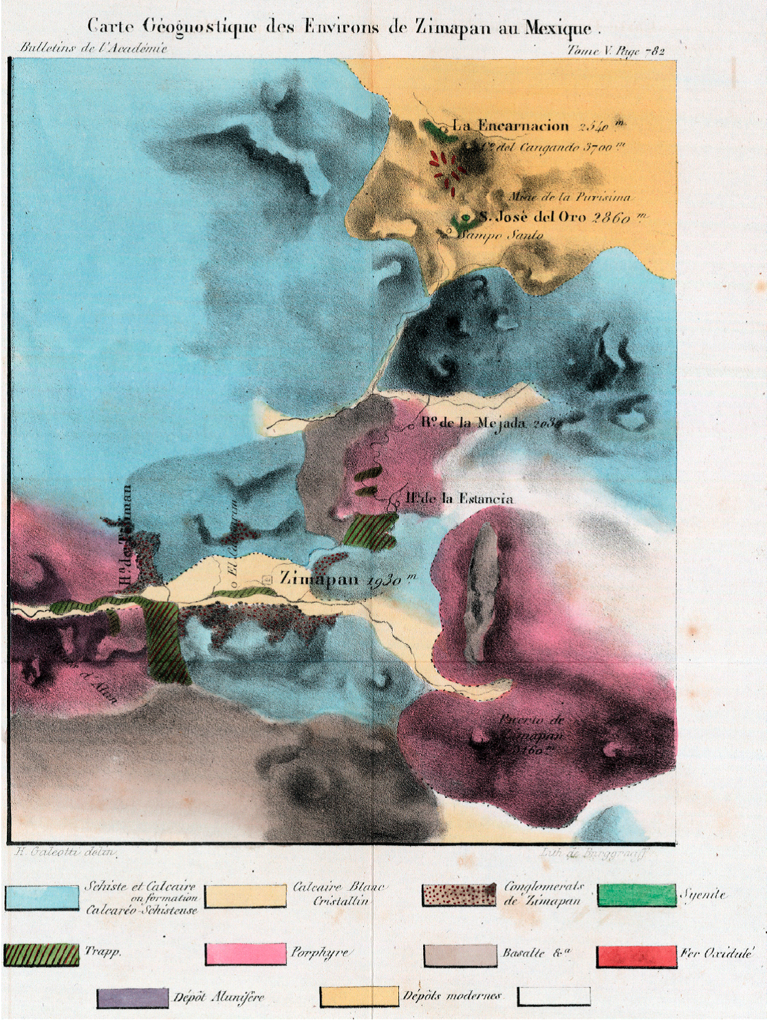
Figure 7
Geognostic map of the Zimapán region by Galeotti (1838a).
Geognostic map of the Zimapán region by Galeotti (1838a).
Thumbnail
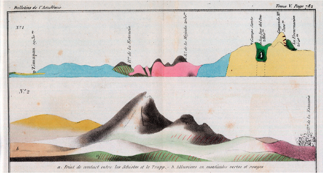
Figure 8
Geognostic cross sections of the Zimapán region by Galeotti (1838a). The trace of No. 1, which is a regional section, has an approximate northeast-southwest orientation. Its trace coincides with the northeastern part of the trace of the section by Burkart (Figure 6), which is marked in blue on Figure 2. No. 2, which is a local section, has an approximate east-west orientation and passes through Hacienda de la Estancia (trace marked in green on Figure 2).
Geognostic cross sections of the Zimapán region by Galeotti (1838a). The trace of No. 1, which is a regional section, has an approximate northeast-southwest orientation. Its trace coincides with the northeastern part of the trace of the section by Burkart (Figure 6), which is marked in blue on Figure 2. No. 2, which is a local section, has an approximate east-west orientation and passes through Hacienda de la Estancia (trace marked in green on Figure 2).
Galeotti distinguishes ten lithological units (Figures 7 and 8), which he describes in the text (Galeotti, 1838b) and in the companion note about an alum deposit in the Barranca de Tolimán (Galeotti, 1838c). In the northeastern part of his map, he delimits two syenite stocks intruded into a unit of white crystalline limestone. He separates this unit from a limestone-slate unit on the remainder of the map, but interprets the white crystalline limestone to have been originally part of the limestone-slate unit before becoming metamorphosed by the intrusions. Based on specimens of the Seminario Nacional de Minería collection, he assumes the limestone to be of Cretaceous age ("étages supérieurs des terrains intermédiaires"). Furthermore, Galeotti distinguishes three volcanic units: a unit of fine-grained mafic rock (trapp) at the base, overlain sequentially by porphyry and basalt. A fairly detailed distribution of these three units is given for the Hacienda de la Estancia - Rancho de la Mejada area (Figures 7 and 8). Moreover, Galeotti mapped the red conglomerate of Zimapán and alluvium, as well as the magnetic iron ore deposits of the La Encarnación region and the alum deposit of Barranca de Tolimán. The map by Galeotti is much more detailed than the previous one by von Gerolt and de Berghes (1827, Figure 3). On the other hand, with exception of the Hacienda de la Estancia region (Figure 2), Galeotti's map is less detailed than the study by Burkart (Figure 6). However, given his wide background, Galeotti seems to have had a better grasp of the regional geology than Burkart, especially regarding stratigraphy. Galeotti (1838b) refers to the work by von Gerolt and de Berghes (1827) but was evidently unaware of the work by Burkart, which was published in Germany in 1836, whereas Galeotti arrived in Mexico in December of 1835 and did field work in the Zimapán area during the summer of 1836 (Quetelet, 1859; McVaugh, 1978).
-
Galeotti, 1838bNotice géologique sur les environs de San José del OroBulletins de l'Académie Royale des Sciences et des Belles-Lettres de Bruxelles, 1838
-
Galeotti, 1838cNotice géognostique sur les mines d'alun de la Barranca de Toliman, au MexiqueBulletins de l'Académie Royale des Sciences et des Belles-Lettres de Bruxelles, 1838
-
von Gerolt and de Berghes (1827Geognostische Karte der vorzüglichsten Bergwerks-Districte des Staates von Mexico: nach astronomischen, barometrischen und mineralogischen Beobachtungen, 1827
-
Galeotti (1838b)Notice géologique sur les environs de San José del OroBulletins de l'Académie Royale des Sciences et des Belles-Lettres de Bruxelles, 1838
-
von Gerolt and de Berghes (1827)Geognostische Karte der vorzüglichsten Bergwerks-Districte des Staates von Mexico: nach astronomischen, barometrischen und mineralogischen Beobachtungen, 1827
-
Quetelet, 1859Notice sur Henri-Guillaume Galeotti, correspondant de l'AcadémieAnnuaire de l'Académie royale des Sciences, des Lettres et des Beaux-Arts de Belgique, 1859
-
McVaugh, 1978Galeotti's botanical work in Mexico: the numbering of his collections and a brief itineraryContributions from the University of Michigan Herbarium, 1978
5. Discussion
The early publications about the Zimapán area are first textual surveys and from 1827 on maps and sections with a gradually increasing level of detail. With exception of the work by Galeotti, these are lithological maps made by graduates of the Freiberg Bergakademie, based on Wernerian geognosy, and motivated by economic interests.
In his section, Burkart (1836) documents map-scale folds in the limestone of the Zimapán area (Figure 6), and from the profiles by von Gerolt and de Berghes (1827), it could be inferred that the slate and porphyry units are involved in map-scale folds between Pechuga and Cardonal (Figure 4) and in the Puerto de Zimapán region (Figure 5). However, these authors do not ponder mountain building. Werner's system did not recognize motions of the continental crust as a cause of inclined strata. An increasing amount of observations of map-scale folds and faults and their geomechanical explanation would only happen some 20 years later, in the middle of the 19th century (e.g., Darwin, 1840), and shortening by large-scale thrust faults of the Sierra Madre Oriental fold-thrust belt (Carrillo-Martínez and Suter, 1982; Suter, 1987; Suter et al., 1997; Contreras and Suter, 2015) and crustal extension by a system of major Cenozoic normal faults (Aljibes half-graben, Suter et al., 1995) would, in the Zimapán area, only be recognized in the late 20th century.
-
Burkart (1836)Aufenthalt und Reisen in Mexico in den Jahren 1825 bis 1834; Bemerkungen über Land, Produkte, Leben und Sitten der Einwohner und Beobachtungen aus dem Gebiete der Mineralogie, Geognosie, Bergbaukunde, Meteorologie, Geographie, 1836
-
von Gerolt and de Berghes (1827)Geognostische Karte der vorzüglichsten Bergwerks-Districte des Staates von Mexico: nach astronomischen, barometrischen und mineralogischen Beobachtungen, 1827
-
Darwin, 1840On the connexion of certain volcanic phenomena in South America; and on the formation of mountain chains and volcanos, as the effects of the same power by which continents are elevatedTransactions of the Geological Society of London, 1840
-
Carrillo-Martínez and Suter, 1982Tectónica de los alrededores de Zimapán, HidalgoLibro-guía de la excursión geológica a la región de Zimapán y áreas circundantesSociedad Geológica Mexicana, 1982
-
Suter, 1987Structural traverse across the Sierra Madre Oriental fold-thrust belt in east-central MexicoGeological Society of America Bulletin, 1987
-
Suter et al., 1997Structure of the Sierra Madre Oriental fold-thrust belt in east-central MexicoII Convención sobre la Evolución Geológica de México, Pachuca, Hidalgo, Libro-guía de las excursiones geológicas, Excursión 2, 1997
-
Contreras and Suter, 2015Mechanical stability model of progradational carbonate platform margins under tectonic loads: Deformation of Cretaceous carbonate platforms in the Sierra Madre Oriental fold-thrust belt (east-central Mexico)Journal of Geophysical Research, 2015
-
Suter et al., 1995The Aljibes half-graben - active extension at the boundary between the trans-Mexican volcanic belt and the southern Basin and Range provinceGeological Society of America Bulletin, 1995
No further geologic studies seem to have been published about the Zimapán area after Galeotti's until the last third of the 19th century, a time of scientific renovation. Education and research were fomented by the scientific positivism of the time and became institutionalized during the governments of Benito Juárez and Porfirio Díaz (Trabulse, 1994; Saldaña and Cuevas Cardona, 1999; Morelos Rodríguez, 2012). The Comisión Geográfico-Exploradora (the national mapping agency of its time) was formed in 1877 and added a natural history section in 1879 (Cuevas Cardona, 2009). It is only during this period, beyond the scope of this review, that renewed studies of the Zimapán area were undertaken, such as the geologic mapping by Mariano Bárcena of the Zimapán region (Bárcena, 1877) and nearby parts of Querétaro State (Bárcena, 1873).
-
Trabulse, 1994Historia de la ciencia en México (versión abreviada), 1994
-
Saldaña and Cuevas Cardona, 1999La invención en México de la investigación científica profesional: El Museo Nacional 1868-1908Quipu, 1999
-
Morelos Rodríguez, 2012La geología mexicana en el siglo XIX, Una revisión histórica de las obras de Antonio del Castillo, Santiago Ramírez y Mariano Bárcena, 2012
-
Cuevas Cardona, 2009Estudios naturalistas de la Secretaría de Fomento: la Sección de Historia Natural de la Comisión Geográfico-Exploradora de México (1882-1915)Geografía e Historia Natural: hacia una historia comparada. Estudio a través de Argentina, México, Costa Rica y Paraguay, 2009
-
Bárcena, 1877)Noticia científica de una parte del Estado de HidalgoAnales del Ministerio de Fomento de la República Mexicana, 1877
-
Bárcena, 1873Memoria presentada al señor Don Blas Balcárcel, director de la Escuela Especial de Ingenieros: Memoria que el Encargado de la Secretaría de Justicia e Instrucción Pública presenta al Congreso de la Unión el 15 de septiembre de 1873, 1873
6. Conclusions
In the early 19th century, possibly no other region in Mexico was studied more geologically, and by more authors, than the Zimapán area. These studies occurred in two spurts; the first one in the early 1800s, and the second one in the 1820s to 1830s. Both seem to have been inspired by Alexander von Humboldt and were much constrained by political and economic circumstances.
The first group of publications about the Zimapán area was by scholars from the Real Seminario de Minería, coincided with Alexander von Humboldt's visit in Mexico 1803-1804, and marked an important step in the establishment of a geologic tradition in Mexico. All of the authors were graduates of the Freiberg mining school in Saxony and adherents of the theory of earth history by Abraham Gottlob Werner. The major contribution is the textual survey of the Zimapán area by Sonneschmid (1804) covering minerals, rocks, and ore deposits, which is based on field work and assaying of samples with a blowpipe and provides a nascent understanding of the regional lithostratigraphy based on the principles by Werner. The contributions by del Río (1803) and von Humboldt (1811) about the Zimapán region mostly rely on Sonneschmid (1804). The issue of the second part of the classical mineralogy textbook by del Río (1805), with a contribution by von Humboldt (1805) about the construction and use of geologic maps and sections, also falls into this period. This flourishing period was terminated by the war of independence and the related economic breakdown.
-
Sonneschmid (1804)Mineralogische Beschreibung der vorzüglichsten Bergwerks-Reviere von Mexico oder Neuspanien, 1804
-
del Río (1803Discurso sobre las formaciones de las montañas de algunos Reales de MinasGaceta de México, 1803
-
von Humboldt (1811)Essai politique sur le royaume de la Nouvelle Espagne avec un atlas physique et géographique, 1811
-
del Río (1805)Elementos de Orictognosia o del conocimiento de los fósiles, dispuestos, según los principios de A.G. Werner, para el Uso del Real Seminario de Minería de México, 1805
-
von Humboldt (1805)Introducción a la pasigrafía geológicaElementos de Orictognosia o del conocimiento de los fósiles dispuestos, según los principios de A.G. Werner, para el uso del Real Seminario de Minería de México, 1805
Mexico's need for foreign investment after gaining independence led to a legal opening, which resulted in a period of activity of German and British mining companies that, in turn, led to a new series of publications about the Zimapán area. These were not limited to textual surveys anymore, but included, for the first time, maps and sections. The ones of central Mexico by von Gerolt and de Berghes (1827) not only cover the Zimapán region but are also the earliest published geologic map and sections of any region in Mexico. Their base map builds on the previous topographic maps of central Mexico by Alexander von Humboldt (1811). Von Gerolt and de Berghes (1827) follow Werner's concepts in their identification of the sequence of rocks in central Mexico. On their geologic map, they roughly define the distribution of volcanic, sedimentary, and ore-bearing rocks based on a crude lithostratigraphy made up of five units. Their work is likely to have been guided by von Humboldt (1823), who verbally describes a section across the trans-Mexican volcanic belt between Oaxtepec in the south and the Sierra de Pachuca in the north (Figure 1).
-
von Gerolt and de Berghes (1827)Geognostische Karte der vorzüglichsten Bergwerks-Districte des Staates von Mexico: nach astronomischen, barometrischen und mineralogischen Beobachtungen, 1827
-
von Humboldt (1811)Essai politique sur le royaume de la Nouvelle Espagne avec un atlas physique et géographique, 1811
-
Von Gerolt and de Berghes (1827)Geognostische Karte der vorzüglichsten Bergwerks-Districte des Staates von Mexico: nach astronomischen, barometrischen und mineralogischen Beobachtungen, 1827
-
von Humboldt (1823)Geognostischer Versuch über die Lagerung der Gebirgsarten in beiden Erdhälften, 1823
This level of geologic knowledge is much improved locally by Burkart (1836), who published a cross section of the Zimapán area based on his fieldwork there in 1828. The section provides much structural and stratigraphic detail such as map-scale folds, the red conglomerate of Zimapán, and detail in the sequence of volcanic rocks. This period not only contains the publication of the 1803 section across the trans-Mexican volcanic belt by von Humboldt (1834), whom Burkart tried to emulate and to whom he dedicated his 1836 book, but also a second, much revised edition of the 1805 mineralogy textbook by del Río (1835a). These two contributions mark, somehow, the end of Wernerian geognosy in central Mexico.
-
Burkart (1836)Aufenthalt und Reisen in Mexico in den Jahren 1825 bis 1834; Bemerkungen über Land, Produkte, Leben und Sitten der Einwohner und Beobachtungen aus dem Gebiete der Mineralogie, Geognosie, Bergbaukunde, Meteorologie, Geographie, 1836
-
von Humboldt (1834)Atlas géographique et physique des régions équinoxiales du Nouveau Continent, 1834
-
del Río (1835a)Elementos de orictognosia o del conocimiento de los fósiles según el sistema de Bercelio, y según los principios de Abraham Gottlob Werner, con la sinonimia inglesa, alemana y francesa para el uso del Seminario Nacional de Minería de México, parte práctica, 1835
The first local geologic map of the Zimapán region, a hand-colored lithograph with ten rock units, was published in 1838 by Galeotti together with cross sections and an explanatory text (Galeotti, 1838a, 1838b). It is based on his field work during the summer of 1836. The map has mostly less resolution than the 1836 section by Burkart. An exception is the Hacienda de La Estancia region, where Galeotti distinguishes three volcanic units: a unit of fine-grained mafic rock (trapp) at the base, overlain sequentially by porphyry and basalt. Contrary to the researchers studying the Zimapán area before him, who all had a background in mining, Galeotti had a wide range of interests in natural history. Consequently, his study introduces new concepts to the regional geology of the Zimapán area, such as biostratigraphy and metamorphism. No further geologic studies seem to have been published about the Zimapán area after Galeotti's until the geologic mapping by Mariano Bárcena during the last third of the 19th century.
-
Galeotti, 1838aCarte géognostique des environs de Zimapan au MéxiqueBulletins de l'Académie Royale des Sciences et des Belles-Lettres de Bruxelles, 1838
-
1838bNotice géologique sur les environs de San José del OroBulletins de l'Académie Royale des Sciences et des Belles-Lettres de Bruxelles, 1838
Acknowledgements
This paper is dedicated to the memory of Zoltan de Cserna [1928-2014], who chaperoned my early steps in Mexico nearly forty years ago. I am thankful to my son Christopher Yuichi and Antonio Augusto De Paz Palacios for their editorial assistance. The staff at the Universitätsbibliothek Basel provided digital reproductions of the map and sections by H.G. Galeotti and the section by J. Burkart. The shaded relief underlying Figures 1 and 2 was downloaded from the GMRT (Global Multi-Resolution Topography) compilation <http://www.geomapapp.org> (Ryan et al., 2009). Many of the primary sources used in this study are available online, albeit without the plates, from Google Books <http://books.google.com>, and the 1803 essay by A.M. del Río from Hemeroteca Digital, Biblioteca Nacional de España <http://www.bne.es/es/Catalogos/HemerotecaDigital>. Copies of the 1827 geologic map and sections by F.K.J. von Gerolt and C. de Berghes (1864 edition by F.W. von Egloffstein) can be downloaded from the David Rumsey Map Collection <http://www.davidrumsey.com>. High-resolution images of the facsimiles included in this paper have been uploaded on my ResearchGate data repository <https://www.researchgate.net/profile/Max_Suter>.
-
Ryan et al., 2009Global Multi-Resolution Topography synthesisGeochemistry, Geophysics, Geosystems, 2009
-
von Gerolt and C. de Berghes (1864 edition by F.W. von EgloffsteinContributions to the geology and the physical geography of Mexico including a geological and topographical map with profiles of some of the principle mining districts, 1864
References
- Acuña, R., 1985, Relaciones Geográficas del Siglo XVI: México, tomo primero: México, D. F., Universidad Nacional Autónoma de México, Instituto de Investigaciones Antropológicas, Serie Antropológica, 63, 400 p. Links
- Aguilera, J.G., 1904, Reseña del desarrollo de la geología en México: Boletín de la Sociedad Geológica Mexicana, 1, 35-117. Links
- Aguirre-Díaz, G.J., López-Martínez, M., 2009, Geologic evolution of the Donguinyó-Huichapan caldera complex, central Mexican Volcanic Belt, Mexico: Journal of Volcanology and Geothermal Research, 179 (1-2), 133-148. Links
- Alencaster Ybarra, G., 2013, Contribución de la mujer al desarrollo de la paleontología en México: Nuestra Tierra, órgano de Difusión de la Estación Regional del Noroeste, UNAM, 19, 3-9. Links
- Amorós Portolés, J.L., 1985, Andrés del Río y su obra, in del Río, A.M., 1985, Elementos de Orictognosia o del conocimiento de los fósiles, dispuestos, según los principios de A.G. Werner, para el Uso del Real Seminario de Minería de México, 1795 & 1805: Madrid, Universidad Complutense, 13-62. Links
- Azuela, L.F., 2005, De las minas al laboratorio: La demarcación de la geología en la Escuela Nacional de Ingenieros (1795-1895): Geografía para el Siglo XXI: México, D.F., Serie libros de investigación, Número 1, Universidad Nacional Autónoma de México, Instituto de Geografía and Facultad de Ingeniería, 186 p. Links
- Azuela, L.F., 2009, La geología en México en el siglo XIX: entre las aplicaciones prácticas y la investigación básica: Revista Geológica de América Central, 41, 99-110. Links
- Bárcena, M., 1873, Memoria presentada al señor Don Blas Balcárcel, director de la Escuela Especial de Ingenieros: Memoria que el Encargado de la Secretaría de Justicia e Instrucción Pública presenta al Congreso de la Unión el 15 de septiembre de 1873, 201-227. Links
- Bárcena, M., 1877, Noticia científica de una parte del Estado de Hidalgo: Anales del Ministerio de Fomento de la República Mexicana, 1, 331-378. Links
- Beck, H., 1958, Alexander von Humboldts "Essay de Pasigraphie", Mexico 1803/04: Forschungen und Fortschritte, 32, 33-39. Links
- Beck, H., 1966, Alexander von Humboldt und Mexiko: Bad Godesberg, Germany, Inter Nationes, 58 p. Links
- Beck, H., Bonacker, W., 1969, Atlas géographique et physique du royaume de la Nouvelle-Espagne. Vom Verfasser auch kurz benannt: Mexico-Atlas. Neudruck des 1811 in Paris erschienenen Werkes, vermehrt um die "Introduction geographique" des "Essai politique du royaume de la Nouvelle-Espagne", die jede Tafel des "Mexiko-Atlasses" erläutert, sowie um 7 Karten des "Atlas géographique et physique des régions équinoxiales du nouveau continent (Paris, 1814-l834) und eine Bildtafel aus den "Vues des Cordillères" (Paris, 1813) die Mexico betreffen: Stuttgart, Brockhaus, 34 and XCII p. Links
- Beidleman, R.G., 2006, California's frontier naturalists: Berkeley, California, University of California Press, 484 p. Links
- Berghaus, H., 1828, Carta geognostica de los principales distritos minerales del estado de Mejiko, formadas sobre observaciones astronomicas, barometricas y mineralogicas, hechas por Federico de Gerolt y Carlos de Berghes. Anno de 1827: Hertha, Zeitschrift für Erd-, Völker- und Staatenkunde, 12, 400-409. Links
- Brading, D.A., 1971, Miners and merchants in Bourbon Mexico 1763-1810: Cambridge, United Kingdom, Cambridge University Press, 382 p. Links
- Burkart, J., 1832, Geognostische Bemerkungen, gesammelt auf einer Reise von Tlalpujahua nach Huetamo, dem Jorullo, Patzcuaro und Valladolid, im Staate von Michoacan: Karsten's Archiv für Mineralogie, Geognosie, Bergbau und Hüttenkunde, 5, 160-207. Links
- Burkart, J., 1836, Aufenthalt und Reisen in Mexico in den Jahren 1825 bis 1834; Bemerkungen über Land, Produkte, Leben und Sitten der Einwohner und Beobachtungen aus dem Gebiete der Mineralogie, Geognosie, Bergbaukunde, Meteorologie, Geographie: Stuttgart, Verlag Schweizerbarth, 1, 392 p.; 2, 286 p. Links
- Carrasco-Velázquez, B.E., Martínez-Hernández, E., Ramírez-Arriaga, E., 2009, Estratigrafía de la Formación El Morro del Paleoceno-Eoceno en Zimapán, Hidalgo: Boletín de la Sociedad Geológica Mexicana, 61 (3), 403-417. Links
- Carrillo Martínez, M., 1998, Normal faulting in the Pathé geothermal area, central Mexico: Geofísica Internacional, 37 (2), 103-111. Links
- Carrillo-Martínez, M., 2000, Geología de la Hoja 14Q-e(7) Zimapán, Estados de Hidalgo y Querétaro: México, D.F., Universidad Nacional Autónoma de México, Instituto de Geología, Carta geológica de México, serie 1:100000, map explanations, 33 p. Links
- Carrillo-Martínez, M., Suter, M., 1982, Tectónica de los alrededores de Zimapán, Hidalgo, in Alcayde, M., de Cserna, Z. (eds.), Libro-guía de la excursión geológica a la región de Zimapán y áreas circundantes: México, D.F., Sociedad Geológica Mexicana, VI Convención Geológica Nacional, 1-20. Links
- Caswell, L.R., 2003, Andrés del Río, Alexander von Humboldt, and the twice-discovered element: Bulletin for the History of Chemistry, 28(1), 35-41. Links
- Cleland, C.E., 2001, Historical science, experimental science, and the scientific method: Geology, 29(11), 987-990. Links
- Contreras, J., Suter, M., 2015, Mechanical stability model of progradational carbonate platform margins under tectonic loads: Deformation of Cretaceous carbonate platforms in the Sierra Madre Oriental fold-thrust belt (east-central Mexico): Journal of Geophysical Research, 120 (2), 1288-1308. doi:10.1002/2014JB011495. Links
- Coville, F.V., 1895, The botanical explorations of Thomas Coulter in Mexico and California: Botanical Gazette, 20 (12), 519-531. Links
- Cuevas Cardona, C., 2009, Estudios naturalistas de la Secretaría de Fomento: la Sección de Historia Natural de la Comisión Geográfico-Exploradora de México (1882-1915), in Lértora Mendoza, C.A. (ed.), Geografía e Historia Natural: hacia una historia comparada. Estudio a través de Argentina, México, Costa Rica y Paraguay: Buenos Aires, Argentina, Ediciones FEPAI, 159-178. Links
- Darwin, C., 1840, On the connexion of certain volcanic phenomena in South America; and on the formation of mountain chains and volcanos, as the effects of the same power by which continents are elevated: Transactions of the Geological Society of London, ser. 2, 5, 601-631. Links
- David, A., Fernández-Armesto, F., Novi, C., Williams, G. (eds.), 2003, The Malaspina Expedition 1789-1794, Journal of the Voyage by Alejandro Malaspina, vol. 2: Panama to the Philippines: London, United Kingdom, The Hakluyt Society, 511 p. Links
- de Cserna, Z., 1990, La evolución de la geología en México (~1500-1929): Revista del Instituto de Geología, Universidad Nacional Autónoma de México, 9, 1-20. Links
- del Río, A.M., 1803, Discurso sobre las formaciones de las montañas de algunos Reales de Minas: Gaceta de México, 11, 411-420. Links
- del Río, A.M., 1805, Elementos de Orictognosia o del conocimiento de los fósiles, dispuestos, según los principios de A.G. Werner, para el Uso del Real Seminario de Minería de México, segunda parte: México, Imprenta de Don Mariano de Zúñiga y Ontiveros, XII and 200 p. Links
- del Río, A.M., 1835a, Elementos de orictognosia o del conocimiento de los fósiles según el sistema de Bercelio, y según los principios de Abraham Gottlob Werner, con la sinonimia inglesa, alemana y francesa para el uso del Seminario Nacional de Minería de México, parte práctica, segunda edición: Filadelfia, Estados Unidos de América, Imprenta de Juan F. Hurtel, 683 p. Links
- del Río, A.M., 1835b, Del Zimapanio: Revista Mexicana, Periódico Científico y Literario, Ignacio Cumplido, México, 2 (I), 83-85. Links
- del Río, A.M., 1985, Elementos de Orictognosia o del conocimiento de los fósiles, dispuestos, según los principios de A.G. Werner, para el Uso del Real Seminario de Minería de México, 1795 & 1805: Madrid, facsimilar edition edited and introduced by Amorós Portolés, J.L., Universidad Complutense, primera parte, XL and 171 p.; segunda parte, XII and 200 p. Links
- del Río, A.M., 1992, Elementos de Orictognosia o del conocimiento de los fósiles, dispuestos, según los principios de A.G. Werner, para el Uso del Real Seminario de Minería de México, 1795 & 1805: México, D. F., facsimilar edition edited and introduced by Rubinóvich Kogan, R., Universidad Nacional Autónoma de México, Instituto de Geología. Links
- Diagre, D., 2004, Michel Scheidweiler y Henri Galeotti, los padres del género Ariocarpus(Cactaceae): Universidad Autonoma de Puebla, Elementos, 54, 53-60. Links
- Dreier, J.E., 2005, The environment of vein formation and ore deposition in the Purisima-Colon vein system, Pachuca Real del Monte district, Hidalgo, Mexico: Economic Geology, 100, 1325-1347. Links
- Engstrand, I.H.W., 1981, Spanish scientists in the New World, The eighteenth-century expeditions: Seattle, Washington, University of Washington Press, 220 p. Links
- Galeotti, H.G., 1838a, Carte géognostique des environs de Zimapan au Méxique: Bulletins de l'Académie Royale des Sciences et des Belles-Lettres de Bruxelles, 5 (11), 782. Links
- Galeotti, H.G., 1838b, Notice géologique sur les environs de San José del Oro: Bulletins de l'Académie Royale des Sciences et des Belles-Lettres de Bruxelles, 5 (11), 737-751. Links
- Galeotti, H.G., 1838c, Notice géognostique sur les mines d'alun de la Barranca de Toliman, au Mexique: Bulletins de l'Académie Royale des Sciences et des Belles-Lettres de Bruxelles, 5 (11), 751-755. Links
- Galeotti, H.G., 1838d, Notice sur un gîte de mercure dans le sol tertiaire récent du Gigante, au Mexique: Bulletins de l'Académie Royale des Sciences et des Belles-Lettres de Bruxelles, 5 (4), 196-202. Links
- Galeotti, H.G., 1839a, Notice sur le calcaire crétacé des environs de Jalapa, au Mexique: Bulletin de la Société Géologique de France, 10, 32-39. Links
- Galeotti, H.G., 1839b, Coup d'oeil sur la Laguna de Chapala au Mexique, avec notes géognostiques: Bulletins de l'Académie Royale des Sciences et des Belles-Lettres de Bruxelles, 6(1), 14-29. Links
- Galeotti, H.G., 1841, Sur les tremblements de terre et les étoiles filantes: Bulletin de l'Académie Royale des Sciences et des Belles-Lettres de Bruxelles, 8 (11), 437-441. Links
- García, G., Querol, F., 1991, Description of some deposits in the Zimapán district, Hidalgo, in Salas, G.P. (ed.), Economic Geology of Mexico: Boulder, Colorado, Geological Society of America, The Geology of North America, P-3, 295-313. Links
- Gerhard, P., 1986, Geografía histórica de la Nueva España 1519-1821: México, D. F., Universidad Nacional Autónoma de México, Instituto de Investigaciones Históricas and Instituto de Geografía, 493 p. Links
- González Claverán, V., 1988, La expedición científica de Malaspina en Nueva España 1789-1794: México, D. F., El Colegio de México, 528 p. Links
- González Claverán, V., 1989, Malaspina en Acapulco: Instituto Guerrerense de Cultura, Colección Biblioteca del Sur, 217 p. Links
- Kiyokawa, M., 1982, Geological survey of the Pachuca-Zimapán area, central Mexico, phase III: Metal Mining Agency of Japan and Consejo de Recursos Minerales (unpublished report), 178 p. Links
- Kowallis, B.J., Swisher III, C.C., Carranza-Castañeda, O., Miller, W.E., Tingey, D.G., 1998, Fission-track and single crystal 40Ar/39Ar laser fusion ages from volcanic ash layers in fossil-bearing Pliocene sediments in central Mexico: Revista Mexicana de Ciencias Geológicas, 15, 157-160. Links
- Kruse, H., 1923, Deutsche Briefe aus Mexiko mit einer Geschichte des Deutsch-Amerikanischen Bergwerksvereins 1824-1838: Veröffentlichungen des Archivs für Rheinisch-Westfälische Wirtschaftsgeschichte, 6, CXX and 304 p. Links
- Lasègue, A., 1845, Musée botanique de M. Benjamin Delessert, Notices sur les collections de plantes et la bibliothèque qui le composent; contenant en outre des documents sur les principaux herbiers d'Europe et l'exposé des voyages entrepris dans l'intérêt de la botanique: Paris, Fortin, Masson et Cie., 588 p. Links
- Laudan, R., 1987, From mineralogy to geology: the foundations of a science, 1650-1830: Chicago, Illinois, University of Chicago Press, 278 p. Links
- Laudan, R., 1992, Book review: Andres Manuel del Río, Elementos de Orictognosia 1795-1805, facsimilar edition edited and introduced by R. Rubinóvich Kogan, Mexico City, Universidad Nacional Autónoma de México, Instituto de Geología, 1992: Sociedad Mexicana de la Ciencia y de la Tecnología, Quipu, 9 (1), 111-114. Links
- Leitner, U., 2000, Humboldt's work on Mexico: Sociedad Mexicana de la Ciencia y de la Tecnología, Quipu, 13 (1), 7-23. Links
- Liesegang, C., 1949, Deutsche Berg- und Hüttenleute in Süd- und Mittel-Amerika: Hamburg, Germany, Ibero-Amerikanisches Forschungsinstitut, Ibero-Amerikanische Studien, Band 19, 119 p. Links
- McVaugh, R., 1978, Galeotti's botanical work in Mexico: the numbering of his collections and a brief itinerary: Contributions from the University of Michigan Herbarium, 11 (5), 291-297. Links
- Morelos Rodríguez, L., 2012, La geología mexicana en el siglo XIX, Una revisión histórica de las obras de Antonio del Castillo, Santiago Ramírez y Mariano Bárcena: Morelia, Michoacán, Secretaría de Cultura del Estado de Michoacán, and México, D.F., Plaza y Valdés Editores, 356p. Links
- Navarro-Barrera, R., 1982, Geología y operación minera del cuerpo Concordia NW, mina El Monte, distrito de Zimapán, Estado de Hidalgo, in Alcayde, M., de Cserna, Z. (eds.), Libro-guía de la excursión geológica a la región de Zimapán y áreas circundantes: México, D.F., Sociedad Geológica Mexicana, VI Convención Geológica Nacional, 28-32. Links
- Nelson, E.C., 1988, Trinity's miner-botanist Dr. Thomas Coulter (1793-1843): Hermathena, 145, 7-21. Links
- Newcomb, S., 2009, The world in a crucible: laboratory practice and geological theory at the beginning of geology: Geological Society of America, Special Paper 449, 204 p. Links
- Nöggerath, J.J., 1828, Literarische Anzeige, Carta geognostica de los principales distritos minerales del Estado de Mexico etc., hechas por Federico de Gerolt y Carlos de Berghes: Journal für Chemie und Physik, 52, 125-128. Links
- Norris, R.M., Webb, R.W., 1990, Geology of California: New York, John Wiley & Sons, 2edition, 541 p. Links
- Nyst, H., Galeotti, H., 1840, Sur quelques fossiles du calcaire jurassique de Tehuacan, au Mexique: Bulletin de l'Académie Royale des Sciences et Belles-Lettres de Bruxelles, 7 (10), 212-221. Links
- Oldroyd, D., 2013, Maps as pictures or diagrams: The early development of geological maps, in Baker, V.R. (ed.), Rethinking the Fabric of Geology: Geological Society of America Special Paper 502, 41-101. Links
- Pferdekamp, W., 1938, Deutsche im frühen Mexiko: Stuttgart, Germany, Deutsche Verlags-Anstalt, Schriftenreihe des deutschen Ausland-Instituts, Neue Reihe, 6, 224 p. Links
- Pferdekamp, W., 1958, Auf Humboldts Spuren, Deutsche im jungen Mexiko: München, Germany, Max Hueber Verlag, 316 p. Links
- Puche Riart, O., Ayala Carcedo, F.J., 1993, La 'Orygthología' de Juan José Elhúyar (1754-1796) y la 'Orictognosia' de Andrés Manuel del Río (1764-1849), primeros tratados geológicos, escritos por españoles en América: Boletín Geológico y Minero, 104 (1), 72-112. Links
- Quelle, O., 1937, Das "Colegio de Minería" in Mexiko unter deutschem wissenschaftlichen Einfluss: Ibero-Amerikanisches Archiv, 11, 376-381. Links
- Quetelet, A., 1859, Notice sur Henri-Guillaume Galeotti, correspondant de l'Académie: Annuaire de l'Académie royale des Sciences, des Lettres et des Beaux-Arts de Belgique, 1859, 139-148. Links
- Ramos Lara, M., 2012, Intercambio de ideas científicas y técnicas en la formación de los ingenieros de minas mexicanos antes, durante y después de la Independencia, in Cairo Carou, H. et al. (eds.), América Latina: La autonomía de una región: Madrid, Consejo Español de Estudios Iberoamericanos and Facultad de Ciencias Políticas y Sociología de la Universidad Complutense de Madrid, Actas de Congreso, 1152-1156. Links
- Randall, R.W., 1972, Real del Monte, a British mining venture in Mexico: Austin, Texas, University of Texas Press, Institute of Latin American Studies, Latin American Monographs, 26, 257 p. Links
- Rowan, S., 2012, The Baron in the Grand Canyon: Friedrich Wilhelm von Egloffstein in the West: Columbia, Missouri, University of Missouri Press, 224 p. Links
- Rubinóvich, R., 1992, Andrés del Río y sus Elementos de Orictognosia de 1795-1805, in del Río, A.M., Elementos de Orictognosia o del conocimiento de los fósiles, dispuestos, según los principios de A.G. Werner, para el Uso del Real Seminario de Minería de México, 1795 & 1805, facsimile edition: México, D. F., Universidad Nacional Autónoma de México, Instituto de Geología, 1-70. Links
- Rubinóvich, R., Lozano, M., 1997, La aventura geológica de Humboldt en la Nueva España, in Alejandro de Humboldt en México: México, D. F., Instituto Nacional de Antropología e Historia and Instituto Goethe, 94-104. Links
- Ryan, W.B.F., Carbotte, S.M., Coplan, J.O., O'Hara, S., Melkonian, A., Arko, R., Weissel, R.A., Ferrini, V., Goodwillie, A., Nitsche, F., Bonczkowski, J., Zemsky, R., 2009, Global Multi-Resolution Topography synthesis: Geochemistry, Geophysics, Geosystems, 10, Q03014, doi: 10.1029/2008GC002332. Links
- Saldaña, J.J., Cuevas Cardona, C., 1999, La invención en México de la investigación científica profesional: El Museo Nacional 1868-1908: Sociedad Mexicana de la Ciencia y de la Tecnología, Quipu, 12 (3), 309-332. Links
- Segerstrom, K., 1962, Geology of south-central Hidalgo and northeastern México, Mexico: U.S. Geological Survey Bulletin 1104-C, 87-162. Links
- Simons, F.S., Mapes, E., 1956, Geology and ore deposits of the Zimapán mining district, State of Hidalgo, Mexico: Washington, D.C., United States Government Printing Office, Geological Survey Professional Paper 284, 128 p. Links
- Sonneschmid, F.T., 1804, Mineralogische Beschreibung der vorzüglichsten Bergwerks-Reviere von Mexico oder Neuspanien: Schleiz, Germany, J. G. Mauke, 334 p. Links
- Strulik, U., 1988, Acerca do papel dos licenciados da Academia de Minas de Freiberg na história da indústria mineira e metalúrgica no México até o fim do século XIX, in Lopes, M.M.,Figueirôa S.F. (eds.), O conhecimento geológico na América Latina: Questões de história e teoria: Campinas, Brazil, Universidade Estadual de Campinas, Instituto de Geociências, 19-31. Links
- Suter, M., 1987, Structural traverse across the Sierra Madre Oriental fold-thrust belt in east-central Mexico: Geological Society of America Bulletin, 98, 249-264. Links
- Suter, M., Carrillo, M., López, M., Farrar, E., 1995, The Aljibes half-graben - active extension at the boundary between the trans-Mexican volcanic belt and the southern Basin and Range province: Geological Society of America Bulletin, 107, 627-641. Links
- Suter, M., Contreras-Pérez, J., Ochoa-Camarillo, H., 1997, Structure of the Sierra Madre Oriental fold-thrust belt in east-central Mexico, in Gómez Caballero, A., Alcayde Orraca, M. (eds.), II Convención sobre la Evolución Geológica de México, Pachuca, Hidalgo, Libro-guía de las excursiones geológicas, Excursión 2: Pachuca, Hidalgo, Instituto de Investigaciones en Ciencias de la Tierra de la Universidad Autónoma del Estado de Hidalgo and Instituto de Geología de la Universidad Nacional Autónoma de México, 45-63. Links
- Trabulse, E., 1984, Historia de la ciencia en México, quinta parte, apéndices e índices: México, D. F., Consejo Nacional de Ciencia y Tecnología and Fondo de Cultura Económica, 591 p. Links
- Trabulse, E., 1994, Historia de la ciencia en México (versión abreviada): México, D. F., Consejo Nacional de Ciencia y Tecnología and Fondo de Cultura Económica, 542 p. Links
- von Gerolt, F., de Berghes, C., 1827, Geognostische Karte der vorzüglichsten Bergwerks-Districte des Staates von Mexico: nach astronomischen, barometrischen und mineralogischen Beobachtungen: Düsseldorf, Germany, Arnz, 6 sheets with maps and profiles and explanatory pamphlet. Links
- von Gerolt, F., de Berghes, C., 1828, Carte géognostique des principaux districts de mines de l'état de Mexico: dressée d'après des observations astronomiques, barométriques et minéralogiques par Frédéric de Gerolt et Charles de Berghes, formant une carte de deux planches et dix coupes géognostiques en quatre planches: Bonn, Germany, 2edition, 6 sheets with maps and profiles and explanatory pamphlet. Links
- von Gerolt, F.K.J., de Berghes, C., 1864, Contributions to the geology and the physical geography of Mexico including a geological and topographical map with profiles of some of the principle mining districts, edited by F.W. von Egloffstein: New York, D. Appleton & Company, 1 sheet with maps and profiles and explanatory pamphlet. Links
- von Humboldt, A., 1805, Introducción a la pasigrafía geológica, in del Río, A.M. (ed.), Elementos de Orictognosia o del conocimiento de los fósiles dispuestos, según los principios de A.G. Werner, para el uso del Real Seminario de Minería de México, segunda parte: México, Don Mariano Joseph de Zúñiga y Ontiveros, 160-173. Links
- von Humboldt, A., 1811, Essai politique sur le royaume de la Nouvelle Espagne avec un atlas physique et géographique: Paris, France, chez F. Schoell, 5 volumes. Links
- von Humboldt, A., 1823, Geognostischer Versuch über die Lagerung der Gebirgsarten in beiden Erdhälften, Straßburg, France, F.G. Levrault, 383 p. Links
- von Humboldt, A., 1834, Atlas géographique et physique des régions équinoxiales du Nouveau Continent: Paris, France , F. Schoell. Links
- von Humboldt, A., 2009, Geographischer und physischer Atlas der Äquinoktial-Gegenden des neuen Kontinents, Frankfurt am Main, Germany, Insel Verlag, 248 p. Links
- von Mentz, B.M., 1982, México en el siglo XIX visto por los Alemanes: México, D. F., Universidad Nacional Autónoma de México, Instituto de Investigaciones Históricas, Serie de Historia Moderna y Contemporánea, 12, 481 p. Links
- Yta, M., Moreno-Tovar, R., 1997, La mineralización en los distritos mineros Pachuca-Real del Monte y Zimapán-su papel en la evolución metalogénica del Estado de Hidalgo, in Gómez Caballero, A., Alcayde Orraca, M. (eds.), II Convención sobre la Evolución Geológica de México, Pachuca, Hidalgo, Libro-guía de las excursiones geológicas, Excursión 3: Pachuca, Hidalgo, Instituto de Investigaciones en Ciencias de la Tierra de la Universidad Autónoma del Estado de Hidalgo and Instituto de Geología de la Universidad Nacional Autónoma de México, 73-87. Links