Soil formation in marine sediments and beach deposits of southern Norway: investigations of soil chronosequences in the Oslofjord region
Formación de suelos en sedimentos marinos y depósitos de playa en el sur de Noruega: investigaciones de cronosecuencias de suelos en la región del fiordo de Oslo
Isabelle Schülli–Maurer1,*, Daniela Sauer1, Karl Stahr1, Ragnhild Sperstad2, and Rolf Sørensen3
1 Institute of Soil Science, University of Hohenheim, Emil–Wolf–Strasse 27, 70599 Stuttgart, Germany. * schuelli@uni-hohenheim.de
]]>
2 Norwegian Institute of Land Inventory (NIJOS), Postboks 115, 1431 Ås, Norway.
3 Norwegian University of Life Sciences, Postboks 5029, 1432 Ås, Norway.
Manuscript received: October 5, 2005 Corrected manuscript received: June 6, 2006 Manuscript accepted: October 10, 2006
ABSTRACT
We investigated the development of Albeluvisols and Podzols with time in southern Norway. The Vestfold region at the western shore of the Oslofjord was chosen because it is characterized by continuous glacio–isostatic uplift for the last 12,000 years. Due to the permanent elevation process, no distinct marine terraces have been built, and the age of the sediments continuously increases with distance from the modern coastline. Albeluvisol development was assessed in a soil chronosequence on loamy marine sediments with ages ranging from approximately 1,800 to 10,200 years. The most obvious change during soil development was that after 4,500 – 5,000 years light tongues intruded from the E horizon into the B horizon, and became more pronounced with time. The combined thickness of the A and E–horizons was constant at 40 ± 3 cm in 9 of the 12 profiles and did not change with age. The organic matter content of the A–horizons, the fine silt to coarse silt ratio of the Btg horizons and the Feo/Fed ratio all decreased with soil age, whereas the thickness of the organic surface horizon and B horizon, as well as the Fed/Fet ratio all increased.
Podzol development was investigated in a chronosequence on sandy beach sediments, the ages of the soils ranging from 2,400 to 8,500 years. All soil properties investigated –the organic matter content of the B horizons, clay content, Feo, Al o, Sio, Feo/Fed and Fed/Fet – tend to increase with advancing podzolization, and are strongly correlated with soil age. Topsoil pH values decrease with age. The characteristic Bh and Bs horizons had developed after approximately 4,000 years.
En este estudio investigamos el desarrollo en el tiempo de Albeluvisoles y Podzoles en el sur de Noruega. Se consideró a la región de Vestfold, en la costa occidental del fiordo de Oslo, dado que esta zona ha estado sujeta a un continuo levantamiento isoestático glacial durante los últimos 12,000 años. Este proceso de levantamiento permanente no ha permitido la formación notable de terrazas marinas y la edad de los sedimentos depositados se incrementa en forma continua en función de la distancia a la línea de costa actual. El desarrollo de Albeluvisoles se evaluó en una cronosecuencia de suelos formados a partir de sedimentos marinos limosos de edades que varían en un intervalo de aproximadamente 1,800 a 10,200 años. El cambio más prominente a lo largo de la evolución de estos suelos ocurrió después de 4,500 a 5,000 años, cuando intrusionan lenguas de coloración clara desde el horizonte E hacia el horizonte B, las cuales se van haciendo más pronunciadas con el tiempo. El espesor combinado de los horizontes A y E se mantuvo constante en 40 ± 3 cm en 9 de los 12 perfiles estudiados y no cambió con el tiempo. Tanto el contenido de materia orgánica de los horizontes A, como la razón entre limos finos y limos gruesos en los horizontes Btg y la razón Feo/Fed disminuyeron con la edad del suelo, mientras que el espesor del horizonte orgánico superfcial, el espesor del horizonte B y la razón Fed/Fet se incrementaron con el tiempo.
El desarrollo de los suelos de tipo Podzol se estudió en una cronosecuencia de suelos desarrollados a partir de depósitos de playa arenosos, cuyas edades varian entre 2,400 y 8,500 años. Todas las propiedades de los suelos –el contenido de materia orgánica en los horizontes B, el contenido de arcilla, Feo, Alo, Sio, Feo/Fed y Fed/Fet – tienden a incrementarse al avanzar la podzolización y están fuertemente correlacionadas con la edad del suelo. El pH del suelo superficial disminuye con el tiempo. Los horizontes característicos Bh y Bs se desarrollaron después de aproximadamente 4,000 años.
Palabras clave: cronosecuencias de suelos, sedimentos marinos, depósitos de playa, Albeluvisoles, Podzoles, fiordo de Oslo, Noruega.
INTRODUCTION
A soil chronosequence consists of soils of different age that have developed on similar parent material and under comparable climatic conditions and vegetation cover (Jenny, 1980; Vreeken, 1975).
Vreeken (1975) distinguished pre–incisive, post–incisive and time–transgressive sequences. The soil development of pre–incisive chronosequences starts isochronously and ends at different times. On the contrary, the soil development of post–incisive sequences begins at different times and ceases isochronously. The beginning and ending of time–transgressive sequences are both at different times. These chronosequences can be divided into time transgressive with or without historical overlap. The studied sequences are post–incisive chronosequences.
]]>
Vidic and Lobnik (1996) investigated a chronosequence (5,000 years – 1.8 million years) in the Ljubljana basin in Slovenia showing the development of Luvisols. They observed steady conditions in soil development after 980,000 years, when progressive and regressive processes reached an equilibrium.
Several investigations on chronosequences have been carried out in North America on soils formed in sandy parent materials which are subjected to podzolization. Singleton and Lavkulich (1987) investigated a chronosequence of very young soils (127–550 years) on beach sands of Vancouver Island. They described chronofunctions of organic matter, oxalate– and dithionite–extractable Fe and Al and of available Ca, Mg and K. A mature Podzol with an E and Bs horizon developed after less than 371 years. Barrett and Schaetzl (1992) examined the podzolization process on sandy terraces of Lake Michigan. The development of a spodic horizon took about 4,000 to 10,000 years. In a further study Barrett (2001) described Podzol development in aeolian sediments at Lake Michigan. In this case, the formation of the spodic Bs–horizon needed more than 5,000 years. In Scandinavia, chronosequences on sandy beach deposits and glacial outwash were established by Mokma et al. (2004). The age of the investigated soils ranged from 230 to 1,800 and 8,300 to 11,300 years. All soils showed E and Bs horizons, and the development of a Podzol took less than 8,300 years. The thickness of the total solum and of the characteristic Podzol horizons increased with time. The comparison of these studies shows that the temporal dynamics of podzolization processes may vary considerably. Most of the differences in the velocity of soil development can be explained by different climate and parent material.
Studies of chronosequences in southern Norway are rare. Semmel (1969) investigated Podzol development on three sandy fluvial terraces in northern Scandinavia at heights of 6 m, 16 m and 25–30 m above sea level. The thickness of the E horizon increased from 3 cm in the 6 m terrace to 8 cm in the 25–30 m terrace, and the Bs horizon increased from 8 cm to 48 cm. Mellor (1985, 1987) examined a chronosequence on neoglacial moraine ridges <100–230 years old. All soils showed signs of podzolization. Properties like organic carbon content, cation exchange capacity, exchangeable cations and dithionite and pyrophosphate soluble Fe and Al increased, pH decreased with time.
Thus far, no studies have been carried out on the development of Albeluvisols with time. In this work, we present a study of soil chronosequences on marine sediments and beach sands of the Oslofjord region, with special focus on the development of Podzols and Albeluvisols.
MATERIALS AND METHODS
Study Area
The study area is located in Vestfold, on the western coast of the Oslofjord (Figure 1), which is part of the temperate zone. The mean annual temperature of the southern Vestfold region is 6 °C (January: –4 °C; July: 16 °C), and the mean precipitation is 1,000 mma–1 (Johansen, 1980). Climate data of Denmark show that the Holocene temperature increased during Preboreal and Boreal and had its maximum in the Atlanticum with a mean July temperature of around 18.5 °C. During Subboreal and Subatlanticum it decreased again (Donner, 1995). Boreal and Subboreal were characterized by dryer conditions, whereas in the Atlanticum and early Subatlanticum the climate was more humid than today.
]]>
The region has been characterized by continuous glacio–isostatic uplift for the last 12,000 years. Consequently, no distinct marine terraces have been built, and the age of the land surface increases continuously with elevation. Several sea level curves for different locations within the Oslofjord, based on a large number of radiocarbon dates (Henningsmoen, 1979; Sørensen, 1999) allowed us to infer the soil age at each location from its elevation above sea level (Figure 2).
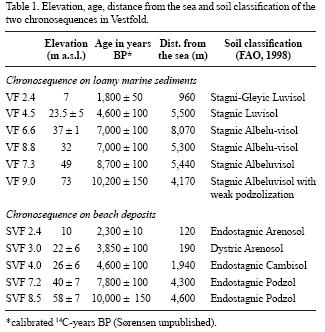
The soil parent materials are non–calcareous loamy marine sediments in which Albeluvisols develop and beach sands with podzol formation. The ages of the investigated soils range from 1,800 to 10,200 years BP (loamy marine sediments) and 2,300 to 10,000 years BP (beach sands) (Table 1). The bedrock of the Vestfold region consists predominantly of Permian monzonite and latite (Lutro and Nordgulen, 2004). Most of the soils are situated under natural mixed forests. The profiles VF 2.4 and SVF 4.0 are under natural deciduous woodland, whereas VF 7.3 and VF 9.0 are under ca. 20 and 40 years old planted spruce forests.
Field methods
The sites were chosen on the basis of calibrated 14C–dated sea level curves for southern Vestfold. Soil pits were dug in nearly flat positions under forest showing no evidence of significant anthropogenic influence. Eleven profiles were described according to FAO (1998) and sampled, six on loamy marine sediments (Albeluvisol sequence) and five on beach sands (Podzol sequence). At least one sample was taken from each horizon, and several samples were taken if the thickness was more than 40 cm. We tried to dig the soil pits deep enough to sample the C horizons, but most of the soils on loamy marine sediments did not show unaltered material within 2 m depth, so that only a few C horizon samples were obtained. The depth of the soil pits ranged from 90 to 230 cm. Structure, texture, presence of coarse fragments, rooting depth, moisture and hydromorphic features were determined in the field, and the bulk density class according to Harrach and Vorderbrügge (1991), based on aggregate size, accomodation, degree of compaction, penetration resistance and the amount of macropores, was estimated. The complete soil descriptions will be published elsewhere.
Laboratory methods
]]>
The moist colour of the samples was determined by comparison with the Munsell soil colour chart. The aggregates in the air dried samples were carefully smashed and the samples passed through a 2 mm sieve. All analyses were performed on the <2 mm fraction. pH was determined in deionised water using a soil:water ratio of 1:2.5 (Schlichting et al., 1995). Organic matter content was calculated from carbon contents measured with a C/N–element analyzer by multiplying with 1.724.
The sand fractions were separated by sieving, and the silt and clay fractions determined by the pipette method (Schlichting et al., 1995). Dithionite–soluble Fe (Fed) was measured by atomic absorption spectrometry (AAS) (Schlichting et al., 1995). Oxalate–extractable Fe (Feo), Al (Alo) and Si (Sio) were measured by inductive coupled plasma–optical emission spetrometry (ICP–OES). Total amounts of Fe (Fet), Al (Alt), Si (Sit), Ti (Tit) and Zr (Zrt) were analyzed in fused discs by X–ray fluorescence.
Chronofunctions for all soil properties and the Tit/Zrt ratio were based on mean values for the different horizons, which were weighted according to bulk density and horizon thickness. They were calculated for each profile to the depth of the shallowest profile, 155 cm for the chronosequence on loamy marine sediments, and 90 cm for the chronosequence on beach deposits.
The analytical results were used to calculate depth functions and chronofunctions of the soil properties investigated. For the chronofunctions, linear (y = ax + b) or exponential (y = eax; y = aebx) equations were applied, depending on which model gave the greatest coefficient of determination (R2).
RESULTS
Chronosequence on loamy marine sediments
All soils of the sequence show light coloured E horizons not only caused by clay depletion but mainly by waterlogging as indicated by hydromorphic features (mottles, manganese coatings) in the horizons below. The colour becomes progressively lighter with increasing age of the soils. Between the Ah and E horizons, a Bw horizon develops, which may partly or completely replace the E horizon. With the exception of the two oldest soils, the lower boundary of the E horizon (or Bw horizon developed in former E horizon) is remarkably constant at 40 ± 3 cm depth. This could be related to the fact that the most extreme and the most frequent temperature changes occur at this depth, leading to differences in physical weathering above and below a 40 cm depth.Such differences may determine the depth of the horizon boundaries, since pedogenic processes tend to follow physical boundaries, if present. The most obvious change during soil development is that light coloured tongues, immerging from the E horizon downwards into the B horizon, developed between 4,500 and 5,000 years and became more strongly pronounced with time.
Since perfect homogeneity of sediments is impossible, the degree of heterogeneity has to be determined. For this purpose we used the ratios of Tit/Zrt of the weighted means of all horizons. Excluding the oldest soil, Ti/Zr ratios ranging from 20 to 25 give a measure of the degree of chemical heterogeneity of the sediments (Table 2).
]]>
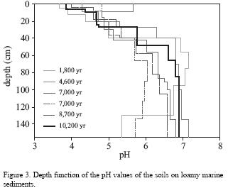
The pH values increase with soil depth, in the youngest soil from 3.7 to 5.4, and in the oldest soil from 3.9 to 6.9 (Figure 3). The type of organic surface layer in the younger soils (up to 7,000 years) ranges from mull to moder, and in the older soils between moder and raw humus. There is a slight decrease in the ratio of fine silt to total silt in the Btg–horizons from 0.53 to 0.29 (Figure 4).
The amounts of Fed, Fe, Alo and Sio are generally smaller in the A and E horizons than in the Btg, Bg and C horizons. The greatest Alo amounts usually occur in the lowest horizons (Bg and C horizons, Table 3). In addition, Feo, Fed and Alo contents are increased in almost all Bw horizons, compared to the adjacent horizons. The Sio contents also show a weak trend to follow this pattern, but only in the older soils.
Usually, the Fed/Fet ratio increases from the A to the Bw horizon and then decreases downwards (Figure 5). However, the youngest soil shows a Fed/Fet maximum in the A horizon, and in the 7,000 years old soil VF 8.8 there are maxima in the E and 2Btg2 horizons. The Feo/Fed ratio tends to decrease with profile depth (Figure 6), though the Feo/Fed ratio is very large in the Btg2 horizon of the youngest profile. The ratio of Fed/Fet increases with soil age from 0.14 to 0.26, showing a very strong correlation (Figure 7). The Feo/Fed ratios do not show any clear trend with time (Figure 7).
]]>
The Btg horizons increase in thickness from 16 cm in the youngest soil to 30 cm and 35 cm in the 4,600 and 7,000 years old soil VF 6.6, and 36 cm in the oldest soil, but decrease to 23 cm in the other 7,000 years old soil VF 8.8, and to 18 cm in the 8,700 years old soil. The depth of the lower boundary of the Btg horizons increases from 56 cm in the youngest to 113 cm in the 7,000 years old soil VF 8.8.
Chronosequence on beach deposits
Evidence for podzolisation first appears in the development of an E horizon between 2,300 and 3,850 years. In soils older than 4,600 years, the Bw horizons have turned into Bhs and Bsw horizons. The 7,800 and 10,000 years old soils show the diagnostic Bs horizon of a mature Podzol.
In the case of the soils on beach sands, the Tit/Zrt ratios of 9.5 to 13.1 (Table 2) can again be used as a measure of the degree of homogeneity of the sediments.
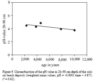
The pH–values increase downwards (Figure 8). For the pH chronofunction, the weighted mean values of 20–90 cm depth were used, because the pH of the A horizon of the 4,600 years old soil shows some influence from the surface. The mean values decrease with soil age from 4.5 in the youngest soil to 3.8 in the oldest (Figure 9).
]]>
The thickness of the organic surface layer increases with age from 5 cm after 2,300 years to 10 cm after 10,000 years. An exception is the 3,850 years old soil with an organic layer of 9 cm. The amount of humus in the B–horizons increases with time from 2.99 kgm–2 to 13.32 kgm–2 (Figure 10). The type of organic layer changes from mull in the youngest soil to typical moder, and finally to raw humus–like moder in the oldest.
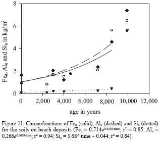
The amounts of Fed, Feo, Alo and Sio are greater in the Bh and Bs horizons than in the respective A horizons, but their maxima occur below the Bh/Bs horizons, in the Bg, BC and C horizons (Table 4). The weighted mean concentrations of Feo, Alo and Sio all increase with profile age (Figure 11). The amounts of Feo and Alo doubled between 3,850 and 4,600 years old soils from 0.89 kgm–2 to 2.15 kgm–2 (Feo) and from 0.87 kgm–2 to 1.72 kgm–2 (Alo). Strong increases also occur in 7,800 and 10,000 years old soils.
]]>
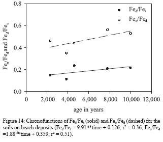
The Fed/Fet and Feo/Fed ratios are both larger for B horizons and smaller for A and C horizons (Figures 12 and 13). The Fed/Fet ratios (weighted means) increase with soil age from 0.15 to 0.22 (Figure 14). The Feo/Fed ratios also increase with age from 0.46 to 0.53 (Figure 14).
]]>
DISCUSSION
Chronosequence on loamy marine sediments
The change in the organic surface layer from mull to moder in soils up to 7,000 years, and to moder and raw humus in the older soils is in accordance with the lower pH values in the topsoil. A slight decrease in the ratio of fine silt to total silt in the Btg horizons indicates in situ weathering of fine silt to clay (Langley–Turnbaugh and Bockheim, 1997).
The increased amounts of Fed in the lower horizons are caused by the formation of iron concretions and mottles in the Btg– and Bg–horizons. The great amounts of Feo, Alo and Sio are attributed to an inhibition of the crystallization process by waterlogging and influence of groundwater in the lower parts of the soils. Formation of organic complexes may prevent crystallization in the Bw horizons, which can explain the higher values of Feo and Alo in the Bw horizons of almost all soils.
The higher Fed/Fet ratios in the Bw horizons are the result of the formation of iron oxides in these horizons (brunification). The increasing Fed/Fet ratio with soil age shows a strong correlation (R2=0.83). This reflects the progressive weathering of Fe–bearing minerals with time. The absence of a clear time trend of Feo/Fed ratios can be explained by other factors (in this case redox processes and organic matter content) having greater impact on the Feo/Fed ratio than the time factor.
The thinner Btg horizon in the 7,000 years old soil VF 8.8 and in the 8,700 years old soil is the result of the progressive growth of tongues downwards from the E into the Btg horizons that results in the replacement of the upper part of the Btg horizons by E/Btg horizons.
Steady state of soil development (when the sum of progressive and regressive processes equals zero; Johnson and Watson–Stegnar, 1987), as found in the older soils of the Ljubljana Basin (Vidic and Lobnik, 1996), could not be observed. Most of the chronofunctions, like organic matter content of the A horizons and the fine silt/total silt ratio of the Btg horizons, decrease with increasing soil age, whereas the Fed/Fet ratios increase with time.
Chronosequence on beach deposits
The weighted mean values of the pH decrease with soil age. This process is followed by proceeding podzolization. The thickness of the organic surface layer increases with age in the same way as acidification proceeds. The change of the organic layer type from mull in the youngest to raw humus–like moder in the oldest soil reflects the ongoing podzolization and hence reduced biological activity.
]]>
The maxima of Fed, Feo and Alo in the Bg, BC and C–horizons and minima of Fed, Feo and Alo in the E horizon of the 10,000 years old soil are attributed to translocation and precipitation of iron and aluminium oxides. The increase of Feo, Alo and Sio (weighted mean values) with profile age indicates progressive podzolization. The same trend was observed in soils on beach sands in Canada (Singleton and Lavkulich, 1987). With the appearence of Bhs and Bsw horizons between 3,850 and 4,600 years, the amounts of Feo and Alo reached more than double the values in younger soils. There is an increase in thickness of the Bs horizons as well as a strong increase of Feo, Alo and Sio between 7,800 and 10,000 years. These results agree well with the increase of horizon thickness observed by Semmel (1969) on fluvial terraces in northern Scandinavia.
The maxima of Fed/Fet and Feo/Fed in the B horizons indicate translocation of iron from the A into the B horizons and formation of pedogenic iron oxides. The Fed/Fet ratios increase with soil age because of progressive weathering and formation of pedogenic iron oxides, whereas the increase in the Feo/Fed ratios with age is probably related to the formation of organic complexes, which inhibit the crystallization process.
In summary, the contents of organic matter, clay, Feo and Alo and the Feo/Fed and Fed/Fet ratios increase with soil age, whereas pH decreases. Tamm (1920) estimated that Podzols in Scandinavia developed within 1,000 to 1,500 years. However, in this study, distinct podzolization was first observed in the 3,850 years old soil, and the diagnostic Bs horizon of a mature Podzol did not develop until 7,800 years.
CONCLUSIONS
The chronosequence on marine sediments in southern Norway shows that, in a temperate climate, E and a Bt horizons developed in loamy sediments after approximately 2,000 years. Topsoil acidification intensified with time. Alo, Fed and Fet increased until an age of about 7,000 years but decreased with further development. The development from Luvisol to Albeluvisol has taken place after about 4,500 years with the formation of characteristic tongues, which became broader, deeper and more distinct with time.
On sandy deposits, which favour podzolization, most of the soil properties investigated (organic matter content of the B–horizons; amounts of Feo, Alo and Sio; ratios of Feo/Fed and Fed/Fet) increase with time, except for pH, which shows a linear decrease. A Bw horizon has formed after 2,300 years. The process of podzolisation first resulted in the development of an E horizon that appears in profiles between 2,300 and 3,850 years. A mature Podzol developed between 4,600 and 7,800 years. Podzolization in beach sands in the Oslofjord region takes more time than in other parts of Scandinavia or northern America probably because of the milder climate in this area.
REFERENCES
Barrett, L.R., 2001, A strand plain soil development sequence in northern Michigan, USA: Catena, 44(3), 163–186. [ Links ]
Barrett, L.R., Schaetzl, R.J., 1992, An examination of podzolization near Lake Michigan using chronofunctions: Canadian Journal of Soil Science, 72(4), 527–541. [ Links ]
Donner, J., 1995, The Quarternary History of Scandinavia: New York, Cambridge University Press, 200 p. [ Links ]
Food and Agriculture Organization (FAO), 1998, World Reference Base for Soil Resources: Rome, Food and Agriculture Organization of the United Nations, World Soil Resources Reports, 84, 88 p. [ Links ]
Harrach, T., Vorderbrügge, T., 1991, Die Wurzelentwicklung von Kulturpflanzen in Beziehung zum Bodentyp und Bodengefüge: Berichte über Landwirtschaft, 204, Sonderheft Bodennutzung und Bodenfruchtbarkeit, 2, 69–82. [ Links ]
Henningsmoen, K.E., 1979, En karbon–datert strandforskyvningskurve fra søndre Vestfold, in Nydal, R., Westin, S., Hafsten, U., Gulliksen, S. (eds.), Fortiden i søkelyset: Trondheim, Universitet Forlag, 239–247. [ Links ]
Jenny, H., 1980, The Soil Resource, Origin and behavior: New York, Springer, 377 p. [ Links ]
Johansen, S., 1980, Vær og klima, in Møller, W. (ed.), Bygd og by i Norge: Vestfold: Oslo, Gyldendal Norsk Forlag, 152–162. [ Links ]
Johnson, D.L., Watson–Stegnar, D., 1987, Evolution model of pedogenesis: Soil Science, 143, 349–366. [ Links ]
Langley–Turnbaugh, S.J., Bockheim, J.G., 1997, Time–dependent changes in pedogenic processes on marine terraces in coastal Oregon: Soil Science Society of America Journal, 61, 1428–1440. [ Links ]
Lutro, O., Nordgulen, Ø., 2004, Oslofeltet, berggrunnskart M 1:250 000: Trondheim, Norges geologiske undersøkelse, 1 map. [ Links ]
Mellor, A., 1985, Soil chronosequences on neoglacial moraine ridges, Jostedalsbreen and Jotunheimen, southern Norway: a quantiative pedogenic approach, in Richards, K.S., Arnett, R.R., Ellis, S. (eds.), Geomorphology and Soils: London, George, Allen and Unwin, 289–308. [ Links ]
Mellor, A., 1987, A pedogenic investigation of some soil chronosequences on neoglacial moraine ridges, southern Norway: examination of soil chemical data using principal components analysis: Catena, 14, 369–381. [ Links ]
Mokma, D.L., Yli–Halla, M., Lindqvist, K., 2004, Podzol formation in sandy soils of Finland: Geoderma, 120, 259–272. [ Links ]
Schlichting, E., Blume, H.–P., Stahr, K., 1995, Bodenkundliches Praktikum: Berlin, Blackwell Wissenschafts–Verlag, 295 p. [ Links ]
Semmel, A., 1969, Verwitterungs– und Abtragungserscheinungen in rezenten Periglazialgebieten (Lappland und Spitzbergen): Würzburger Geographische Arbeiten, 26, 82. [ Links ]
Singleton, G.A., Lavkulich, L.M., 1987, A soil chronosequence on beach sands, Vancouver Island, British Columbia: Canadian Journal of Soil Science, 67, 795–810. [ Links ]
Sørensen, R., 1999, En 14C datert og dendrokronologisk kalibrert strandforskyvnings–kurve for søndre Østfold, Sørøst–Norge: AmS–Rapport 12A, Stavanger, 227–242. [ Links ]
Tamm, O., 1920, Bodenstudien in der Nordschwedischen Nadelwaldregion: Meddelanden från Statens Skogsfoersoeksanstalt, 17, 49–300. [ Links ]
Vidic, N.J., Lobnik, F., 1996, Rates of soil development of the chronosequence in the Ljubeljana Basin, Slovenia: Geoderma, 76, 5–64. [ Links ]
Vreeken, W.J., 1975, Principal kinds of chronosequences and their significance in soil History: Journal of Soil Science, 26, 378–394. [ Links ] ]]>20014433163-18619927244527-5411995200Food and Agriculture Organization (FAO)199884881991204269-821979239-24719803771980152-1621987143349-3661997611428-144020041985289-308198714369-3812004120259-272199529519692682198767795-8101999227-24219201749-3001996765-64197526378-394
 a–1 (Johansen, 1980). Climate data of Denmark show that the Holocene temperature increased during Preboreal and Boreal and had its maximum in the Atlanticum with a mean July temperature of around 18.5 °C. During Subboreal and Subatlanticum it decreased again (Donner, 1995). Boreal and Subboreal were characterized by dryer conditions, whereas in the Atlanticum and early Subatlanticum the climate was more humid than today.