<?xml version="1.0" encoding="ISO-8859-1"?><article xmlns:mml="http://www.w3.org/1998/Math/MathML" xmlns:xlink="http://www.w3.org/1999/xlink" xmlns:xsi="http://www.w3.org/2001/XMLSchema-instance">
<front>
<journal-meta>
<journal-id>1026-8774</journal-id>
<journal-title><![CDATA[Revista mexicana de ciencias geológicas]]></journal-title>
<abbrev-journal-title><![CDATA[Rev. mex. cienc. geol]]></abbrev-journal-title>
<issn>1026-8774</issn>
<publisher>
<publisher-name><![CDATA[Universidad Nacional Autónoma de México, Instituto de Geología]]></publisher-name>
</publisher>
</journal-meta>
<article-meta>
<article-id>S1026-87742009000200013</article-id>
<title-group>
<article-title xml:lang="en"><![CDATA[Beach sand composition and provenance in a sector of the southwestern Mexican Pacific]]></article-title>
<article-title xml:lang="es"><![CDATA[Composición y proveniencia de arena de playa en un sector del suroeste del Pacífico mexicano]]></article-title>
</title-group>
<contrib-group>
<contrib contrib-type="author">
<name>
<surname><![CDATA[Carranza-Edwards]]></surname>
<given-names><![CDATA[Arturo]]></given-names>
</name>
<xref ref-type="aff" rid="A01"/>
</contrib>
<contrib contrib-type="author">
<name>
<surname><![CDATA[Kasper-Zubillaga]]></surname>
<given-names><![CDATA[Juan José]]></given-names>
</name>
<xref ref-type="aff" rid="A01"/>
</contrib>
<contrib contrib-type="author">
<name>
<surname><![CDATA[Rosales-Hoz]]></surname>
<given-names><![CDATA[Leticia]]></given-names>
</name>
<xref ref-type="aff" rid="A01"/>
</contrib>
<contrib contrib-type="author">
<name>
<surname><![CDATA[Morales-de la Garza]]></surname>
<given-names><![CDATA[Eduardo Alfredo]]></given-names>
</name>
<xref ref-type="aff" rid="A01"/>
</contrib>
<contrib contrib-type="author">
<name>
<surname><![CDATA[Lozano-Santa Cruz]]></surname>
<given-names><![CDATA[Rufino]]></given-names>
</name>
<xref ref-type="aff" rid="A02"/>
</contrib>
</contrib-group>
<aff id="A01">
<institution><![CDATA[,Universidad Nacional Autónoma de México Instituto de Ciencias del Mar y Limnología ]]></institution>
<addr-line><![CDATA[México D.F.]]></addr-line>
<country>Mexico</country>
</aff>
<aff id="A02">
<institution><![CDATA[,Universidad Nacional Autónoma de México Instituto de Geología ]]></institution>
<addr-line><![CDATA[México D.F.]]></addr-line>
<country>Mexico</country>
</aff>
<pub-date pub-type="pub">
<day>00</day>
<month>08</month>
<year>2009</year>
</pub-date>
<pub-date pub-type="epub">
<day>00</day>
<month>08</month>
<year>2009</year>
</pub-date>
<volume>26</volume>
<numero>2</numero>
<fpage>433</fpage>
<lpage>447</lpage>
<copyright-statement/>
<copyright-year/>
<self-uri xlink:href="http://www.scielo.org.mx/scielo.php?script=sci_arttext&amp;pid=S1026-87742009000200013&amp;lng=en&amp;nrm=iso"></self-uri><self-uri xlink:href="http://www.scielo.org.mx/scielo.php?script=sci_abstract&amp;pid=S1026-87742009000200013&amp;lng=en&amp;nrm=iso"></self-uri><self-uri xlink:href="http://www.scielo.org.mx/scielo.php?script=sci_pdf&amp;pid=S1026-87742009000200013&amp;lng=en&amp;nrm=iso"></self-uri><abstract abstract-type="short" xml:lang="en"><p><![CDATA[Sandy sediment samples from eleven beaches in southwestern Mexico were texturally, petrologic and chemically analyzed. Our goals were to interpret the provenance of the sands in terms of grain size, petrogrology and geochemistry and to observe if the beach environment reflects accurately the source rock in three adjacent river basins dominated by sedimentary, volcanic and plutonic rocks respectively. Three littoral segments were divided in terms of lithological differences: the Cihuatlán (western), Armería (central) and Coahuayana (eastern) river basins and their respective beach segments. The Cihuatlán river basin is influenced by granitoids, whereas the Armería and Coahuayana river basins are dominated by the influence of intermediate to basic volcanic rocks and sedimentary rocks represented by limestones. This is supported by the enrichment of Fe2O3, CaO, MgO, TiO2, V, Cr, Co and Zn, and a depletion of SiO2, Al2O3, Na2O K2O, Ba, Sr and Rb from the western segment toward the eastern segment. The chemical index of alteration (C.I.A.) values were higher in beaches from the Armería and Coahuayana river segments. This is probably caused by weathering feldspars in the volcanic lithics due to more humid conditions in the source area. Sedimentary calcareous lithics in the Armería and Coahuayana river basins are depleted due to their low resistance to high energy of fluvial and river-marine conditions. Despite the fact limestone outcrops are more than 40 % in the central (Armería) and eastern (Coahuayana) basins, the beach sediments do not reflect limestone sources. Heavy minerals concentration is related to the influence of Armería and Coahuayana river basins and likelly produced by the erosion of intermediate to mafic Quaternary lavas.]]></p></abstract>
<abstract abstract-type="short" xml:lang="es"><p><![CDATA[Se analizó la textura, petrología y geoquímica de sedimentos arenosos de once playas del suroeste de México. El objetivo fue interpretar la procedencia de las arenas en términos del tamaño de grano, petrología y geoquímica y observar si el ambiente de playa refleja con precisión la roca fuente en playas de tres cuencas adyacentes en las que dominan rocas sedimentarías, volcánicas y plutónicas. En función de diferencias litológicas y climáticas, se consideraron tres segmentos litorales sujetos a la influencia de las cuencas de los ríos Cihuatlán, Armería y Coahuayana. La cuenca del Río Cihuatlán está influenciada por granitoides, mientras que las cuencas de los ríos Armería y Coahuayana están dominadas por la influencia de rocas volcánicas intermedias a básicas y rocas sedimentarias representadas por calizas. Esto se ve apoyado por el enriquecimiento de Fe2O3, CaO, MgO, TiO2, V, Cr, Co y Zn y el empobrecimiento de SiO2, Al2O3, Na2O K2O, Ba, Sr and Rb, desde el segmento occidental hacia el segmento oriental. El elevado índice químico de alteración (C.I.A.) en las arenas de playa de los segmentos Armería y Coahuayana se debe a condiciones de mayor humedad en las cuencas de aporte de estos dos ríos, las cuales probablemente están causando el intemperismo de feldespatos y de los líticos volcánicos. Los líticos calcáreos en las arenas de los segmentos Armería y Coahuayana se encuentran empobrecidos debido a su baja resistencia química y mecánica a condiciones fluviales y marinas de alta energía. A pesar de que los afloramientos de calizas son mayores que 40 % en las cuencas central (Armería) y oriental (Coahuayana), los sedimentos de las playas no reflejan la presencia de calizas como roca fuente. La concentración de minerales pesados se asocia con la influencia de la litología de las cuencas Armería y Coahuayana y son posible producto de la erosión de las lavas cuaternarias intermedias y máficas.]]></p></abstract>
<kwd-group>
<kwd lng="en"><![CDATA[sand]]></kwd>
<kwd lng="en"><![CDATA[beach]]></kwd>
<kwd lng="en"><![CDATA[composition]]></kwd>
<kwd lng="en"><![CDATA[provenance]]></kwd>
<kwd lng="en"><![CDATA[Colima]]></kwd>
<kwd lng="en"><![CDATA[Pacific]]></kwd>
<kwd lng="en"><![CDATA[southwestern Mexico]]></kwd>
<kwd lng="es"><![CDATA[composición]]></kwd>
<kwd lng="es"><![CDATA[arena]]></kwd>
<kwd lng="es"><![CDATA[playa]]></kwd>
<kwd lng="es"><![CDATA[procedencia]]></kwd>
<kwd lng="es"><![CDATA[Colima]]></kwd>
<kwd lng="es"><![CDATA[Pacífico]]></kwd>
<kwd lng="es"><![CDATA[sur de México]]></kwd>
</kwd-group>
</article-meta>
</front><body><![CDATA[ <p align="center"><font face="verdana" size="4"><b>Beach sand composition and provenance in a sector of the southwestern Mexican Pacific</b></font></p>     <p align="center"><font face="verdana" size="2">&nbsp;</font></p>     <p align="center"><font face="verdana" size="3"><b>Composici&oacute;n y proveniencia de arena de playa en un sector del suroeste del Pac&iacute;fico mexicano  </b></font></p>     <p align="center"><font face="verdana" size="2">&nbsp;</font></p>     <p align="center"><font face="verdana" size="2"><b>Arturo Carranza&#150;Edwards<sup>1, *</sup>, Juan Jos&eacute; Kasper&#150;Zubillaga<sup>1</sup>, Leticia Rosales&#150;Hoz<sup>1</sup>, Eduardo Alfredo Morales&#150;de la Garza<sup>1</sup>, Rufino Lozano&#150;Santa Cruz<sup>2</sup></b></font></p>     <p align="center"><font face="verdana" size="2">&nbsp;</font></p>     <p align="justify"><font face="verdana" size="2"><i><sup>1</sup> Instituto de Ciencias del Mar y Limnolog&iacute;a, Universidad Nacional Aut&oacute;noma de M&eacute;xico, Geolog&iacute;a Marina y Ambiental, Ciudad Universitaria, Circuito Exterior, Del. Coyoac&aacute;n, 04510 M&eacute;xico D.F., Mexico. * <a href="mailto:dr.arturo.carranza@gmail.com">dr.arturo.carranza@gmail.com</a></i></font></p>     <p align="justify"><font face="verdana" size="2"><i><sup>2</sup> Instituto de Geolog&iacute;a, Universidad Nacional Aut&oacute;noma de M&eacute;xico, Ciudad Universitaria, Circuito Exterior, Del. Coyoac&aacute;n, 04510 M&eacute;xico D.F., Mexico.</i></font></p>     <p align="justify"><font face="verdana" size="2">&nbsp;</font></p>     <p align="justify"><font face="verdana" size="2">Manuscript received: September 1, 2008    ]]></body>
<body><![CDATA[<br> Corrected manuscript received: Marzo 11, 2009    <br> Manuscript accepted: March 16, 2009</font></p>     <p align="justify"><font face="verdana" size="2">&nbsp;</font></p>     <p align="justify"><font face="verdana" size="2"><b>ABSTRACT</b></font></p>     <p align="justify"><font face="verdana" size="2">Sandy sediment samples from eleven beaches in southwestern Mexico were texturally, petrologic and chemically analyzed. Our goals were to interpret the provenance of the sands in terms of grain size, petrogrology and geochemistry and to observe if the beach environment reflects accurately the source rock in three adjacent river basins dominated by sedimentary, volcanic and plutonic rocks respectively. Three littoral segments were divided in terms of lithological differences: the Cihuatl&aacute;n (western), Armer&iacute;a (central) and Coahuayana (eastern) river basins and their respective beach segments. The Cihuatl&aacute;n river basin is influenced by granitoids, whereas the Armer&iacute;a and Coahuayana river basins are dominated by the influence of intermediate to basic volcanic rocks and sedimentary rocks represented by limestones. This is supported by the enrichment of Fe<sub>2</sub>O<sub>3</sub>, CaO, MgO, TiO<sub>2</sub>, V, Cr, Co and Zn, and a depletion of SiO<sub>2</sub>, Al<sub>2</sub>O<sub>3</sub>, Na<sub>2</sub>O K<sub>2</sub>O, Ba, Sr and Rb from the western segment toward the eastern segment. The chemical index of alteration (C.I.A.) values were higher in beaches from the Armer&iacute;a and Coahuayana river segments. This is probably caused by weathering feldspars in the volcanic lithics due to more humid conditions in the source area. Sedimentary calcareous lithics in the Armer&iacute;a and Coahuayana river basins are depleted due to their low resistance to high energy of fluvial and river&#150;marine conditions. Despite the fact limestone outcrops are more than 40 % in the central (Armer&iacute;a) and eastern (Coahuayana) basins, the beach sediments do not reflect limestone sources. Heavy minerals concentration is related to the influence of Armer&iacute;a and Coahuayana river basins and likelly produced by the erosion of intermediate to mafic Quaternary lavas. </font></p>     <p align="justify"><font face="verdana" size="2"><b>Key words:</b> sand, beach, composition, provenance, Colima, Pacific, southwestern Mexico.</font></p>     <p align="justify"><font face="verdana" size="2">&nbsp;</font></p>     <p align="justify"><font face="verdana" size="2"><b>RESUMEN</b></font></p>     <p align="justify"><font face="verdana" size="2">Se analiz&oacute; la textura, petrolog&iacute;a y geoqu&iacute;mica de sedimentos arenosos de once playas del suroeste de M&eacute;xico. El objetivo fue interpretar la procedencia de las arenas en t&eacute;rminos del tama&ntilde;o de grano, petrolog&iacute;a y geoqu&iacute;mica y observar si el ambiente de playa refleja con precisi&oacute;n la roca fuente en playas de tres cuencas adyacentes en las que dominan rocas sedimentar&iacute;as, volc&aacute;nicas y plut&oacute;nicas. En funci&oacute;n de diferencias litol&oacute;gicas y clim&aacute;ticas, se consideraron tres segmentos litorales sujetos a la influencia de las cuencas de los r&iacute;os Cihuatl&aacute;n, Armer&iacute;a y Coahuayana. La cuenca del R&iacute;o Cihuatl&aacute;n est&aacute; influenciada por granitoides, mientras que las cuencas de los r&iacute;os Armer&iacute;a y Coahuayana est&aacute;n dominadas por la influencia de rocas volc&aacute;nicas intermedias a b&aacute;sicas y rocas sedimentarias representadas por calizas. Esto se ve apoyado por el enriquecimiento de Fe<sub>2</sub>O<sub>3</sub>, CaO, MgO, TiO<sub>2</sub>, V, Cr, Co y Zn y el empobrecimiento de SiO<sub>2</sub>, Al<sub>2</sub>O<sub>3</sub>, Na<sub>2</sub>O K<sub>2</sub>O, Ba, Sr and Rb, desde el segmento occidental hacia el segmento oriental. El elevado &iacute;ndice qu&iacute;mico de alteraci&oacute;n (C.I.A.) en las arenas de playa de los segmentos Armer&iacute;a y Coahuayana se debe a condiciones de mayor humedad en las cuencas de aporte de estos dos r&iacute;os, las cuales probablemente est&aacute;n causando el intemperismo de feldespatos y de los l&iacute;ticos volc&aacute;nicos. Los l&iacute;ticos calc&aacute;reos en las arenas de los segmentos Armer&iacute;a y Coahuayana se encuentran empobrecidos debido a su baja resistencia qu&iacute;mica y mec&aacute;nica a condiciones fluviales y marinas de alta energ&iacute;a. A pesar de que los afloramientos de calizas son mayores que 40 % en las cuencas central (Armer&iacute;a) y oriental (Coahuayana), los sedimentos de las playas no reflejan la presencia de calizas como roca fuente. La concentraci&oacute;n de minerales pesados se asocia con la influencia de la litolog&iacute;a de las cuencas Armer&iacute;a y Coahuayana y son posible producto de la erosi&oacute;n de las lavas cuaternarias intermedias y m&aacute;ficas.</font></p>     <p align="justify"><font face="verdana" size="2"><b>Palabras clave:</b> composici&oacute;n, arena, playa, procedencia, Colima, Pac&iacute;fico, sur de M&eacute;xico. </font></p>     ]]></body>
<body><![CDATA[<p align="justify"><font face="verdana" size="2">&nbsp;</font></p>     <p align="justify"><font face="verdana" size="2"><b>INTRODUCTION </b></font></p>     <p align="justify"><font face="verdana" size="2">The composition of littoral sediments and their textural, compositional and geochemical variation is controlled by diverse factors like waves, wind, and longshore currents, climate relief and source composition (Folk, 1974; Komar, 1976; Ibbeken and Schleyer, 1991; Carranza&#150;Edwards and Rosales&#150;Hoz, 1995; Carranza&#150;Edwards, 2001; Kasper&#150;Zubillaga and Carranza&#150;Edwards, 2005). Coasts formed by non&#150;consolidated sediments are around 40 % percent of the global coastline composed of sand and gravel beaches (Bird, 2000). Beaches are exposed to different marine, fluvial, and eolian processes such as wave and tidal regimes, fluvial discharges and wind transport among others factors. Furthermore, these factors control the grain&#150;size and sand composition of the beaches in terms of mineralogy and geochemistry.</font></p>     <p align="justify"><font face="verdana" size="2">In addition, geomorphological features in the coast may also have a control in the grain&#150;size, composition and geochemistry of beaches (Le Pera and Critelli, 1997). For instance, some beaches in protected embayments may have coarse grain sizes as result of little energy and removal of finer sizes offshore (Komar, 1976). Furthermore, provenance of coastal sands may be related to different tectonic settings, as it has been documented in several papers (Klitgord and Mammerickx, 1982; Nesbitt and Young, 1982; Carranza Edwards <i>et al.</i>, 1994; Kasper&#150;Zubillaga <i>et al.</i>, 1999). </font></p>     <p align="justify"><font face="verdana" size="2">The studied southwestern coastline shows a landscape of high relief due to the presence of the Mexican Volcanic Belt and alluvial deposits that probably provides of different beach and river sand compositional characteristics.</font></p>     <p align="justify"><font face="verdana" size="2">The goal of this paper is to characterize the composition and provenance of sand samples collected from eleven beaches and three major fluvial basins draining throughout continental rocks in southwestern Mexico, in order to analyze and distinguish among their grain size, petrography and geochemistry. Our objective is to establish the influence of the lithological character of the source rocks in the texture and composition of the beach sands. We are interested to know how much the extensive limestone, volcanic and plutonic rock outcrops are reflected in the composition of the studied beach sands associated with the river basins. This coastal area was chosen due to its importance from the geological point of view because it is likely that beach sands are compositionally influenced by a mix of plutonic, volcanic source rocks.</font></p>     <p align="justify"><font face="verdana" size="2">&nbsp;</font></p>     <p align="justify"><font face="verdana" size="2"><b>STUDY AREA</b></font></p>     <p align="justify"><font face="verdana" size="2">The study area is located in the coastal area of the Cihuatl&aacute;n, Armer&iacute;a, and Coahuayana basins, Mexico (<a href="/img/revistas/rmcg/v26n2/a13f1.jpg" target="_blank">Figure 1</a>). For our goal, 35 sand samples were collected and analyzed in terms of grain size, petrology and geochemistry as part of a long&#150;term regional project (<a href="/img/revistas/rmcg/v26n2/a13f1.jpg" target="_blank">Figure 1</a>). Three protected beaches (sites B, C, D,) are located near cliffs and protected embayments. The rest of the beach sites are located as open&#150;sea coastal sedimentary environments in barrier beaches. Relief (INEGI <i>et al.</i>, 1990) is relatively low in the coastal eastern portion (<a href="#f2">Figure 2</a>) and the highest elevations are related to the Volcan del Fuego de Colima (3838 m asl) and the Nevado de Colima (4240 m asl) volcanoes (Tamayo, 2002). The Colima coastal region is part of the south limit of the geomorphic region known as Southwestern Coastal Plain. </font></p>     <p align="center"><font face="verdana" size="2"><a name="f2"></a></font></p>     ]]></body>
<body><![CDATA[<p align="center"><font face="verdana" size="2"><img src="/img/revistas/rmcg/v26n2/a13f2.jpg"></font></p>     <p align="justify"><font face="verdana" size="2">There are three main river systems that supply sediments from the potential source rocks to the beach: a) Cihuatl&aacute;n river basin (sites A, B, C, D); b) Armer&iacute;a river basin (sites E, F, G, H, I that are related to the barrier beach of Cuyutl&aacute;n Lagoon, which receives sediments from the Armer&iacute;a river); and c) Coahuayana river basin (sites J, K) (<a href="/img/revistas/rmcg/v26n2/a13f1.jpg" target="_blank">Figure 1</a>). The plutonic rocks (Padilla y S&aacute;nchez Aceves&#150;Quesada, 1990) are mainly granite&#150;granodiorite found in the Cihuatl&aacute;n river basin. These crystalline rocks are now exposed and are a potential source for quartz and feldspars to the beach sediments transported through the Cihuatl&aacute;n river. In the other two basins (Armer&iacute;a river and Coahuayana river), the exposed rocks are mainly volcanic of intermediate to mafic composition and sedimentary rocks, mainly limestone (<a href="/img/revistas/rmcg/v26n2/a13f1.jpg" target="_blank">Figure 1</a>, <a href="#t1">Table 1</a>). The Armer&iacute;a and Coahuayana basins are expected to be a source of volcanic and sedimentary lithic fragments for the study area beach sediments. The eastern portion of Colima belongs to the Colima rift (Luhr <i>et al.</i>, 1985; Campos&#150;Enr&iacute;quez and Alatorre&#150;Zamora, 1998). The outcrops (<a href="/img/revistas/rmcg/v26n2/a13f1.jpg" target="_blank">Figure 1</a>) of this volcanic activity and the alluvium are a superficial expression of the Colima graben or Colima rift. The Colima Volcano is found inside the Colima rift zone (Verma and Luhr, 1993). In contrast, the western portion of the studied coast, the Jalisco block is a tectonic block or micro&#150;plate; more or less rigid (Stock, 1993). Cretaceous granitic rocks from an arc root tectonic environment have been reported in this block (Ortega Guti&eacute;rrez <i>et al.</i>, 1992). </font></p>     <p align="center"><font face="verdana" size="2"><a name="t1"></a></font></p>     <p align="center"><font face="verdana" size="2"><img src="/img/revistas/rmcg/v26n2/a13t1.jpg"></font></p>     <p align="justify"><font face="verdana" size="2">The modern climate is tropical with a rainy summer. The average annual precipitation varies from 800 mm in the low areas to 1,200 mm in the highest divides (Tamayo, 2002). No data are available to give a more accurate scenario of the coastal dynamics in Colima. Terrain in the three main basins varies from lowlands to highlands as shown in <a href="#f2">Figure 2</a>. </font></p>     <p align="justify"><font face="verdana" size="2">&nbsp;</font></p>     <p align="justify"><font face="verdana" size="2"><b>MATERIALS AND METHODS</b></font></p>     <p align="justify"><font face="verdana" size="2">Approximately 200 grams of sand samples were collected by hand from the uppermost centimeter of the following beaches: A) Playa de Oro, B) Bah&iacute;a de Santiago, C) Bah&iacute;a de Manzanillo, D) Ventanas, E) Punta Campos, F) West Cuyutl&aacute;n, G) Cuyutl&aacute;n, H) Para&iacute;so, I) Boca de Pascuales, J) Tecuanillo, and K) Boca de Apiza. The beach profiles are shown in <a href="#f3">Figure 3</a>. Sand samples were taken from inshore, foreshore and backshore environments. Sand sampling sites were choosen taking in account coastal areas near small protected embayments like the Santiago and Manzanillo bays and coastal areas directly exposed to the open sea in order to observe the grain&#150;size, petrographic and geochemical trends. Beach profiles were surveyed using a stadia, rod, and level. Distance measurements along the beach profile were performed with an optical device with one centimeter precision. </font></p>     <p align="center"><font face="verdana" size="2"><a name="f3"></a></font></p>     <p align="center"><font face="verdana" size="2"><img src="/img/revistas/rmcg/v26n2/a13f3.jpg"></font></p>     ]]></body>
<body><![CDATA[<p align="justify"><font face="verdana" size="2">Particle size was determined by sieving each sample. The textural parameters (<a href="#t2">Table 2</a>) were obtained using the formulas and limits suggested by Folk (1974). In our sedimentary petrographic analysis, we counted 300 grains per slide, using the point counting method of Franzinelli and Potter (1983), to survey the provenance of lithic fragments and not only of monomineralic fractions. The observed grain classes fields (<a href="/img/revistas/rmcg/v26n2/a13t3.jpg" target="_blank">Table 3</a>) were: monocrystalline quartz (Qm), polycrystalline quartz (Qp), total feldspars (Ft), volcanic lithic fragments (Lv), metamorphic lithic fragments (Lm), plutonic lithic fragments (Lp), sedimentary lithic fragments (Ls), and diverse heavy minerals (HM). In this study we used the light minerals to infer the source rocks. </font></p>     <p align="center"><font face="verdana" size="2"><a name="t2"></a></font></p>     <p align="center"><font face="verdana" size="2"><img src="/img/revistas/rmcg/v26n2/a13t2.jpg"></font></p>     <p align="justify"><font face="verdana" size="2">Major and trace elements concentration (<a href="/img/revistas/rmcg/v26n2/a13t4.jpg" target="_blank">Tables 4</a>, <a href="#t5">5</a>) were determined with a SIEMENS sequential X&#150;ray fluorescence spectrometer, equipped with an end&#150;window Rh target tube and a 125 &mu;m thin Beryllium window. CaO content includes carbonates present in the analyzed sand fraction. For the analysis of major elements, one gram of each sand sample was grinded and fused with nine grams of a 1:1 mix of Li<sub>2</sub>B<sub>4</sub>O<sub>7</sub>:LiBO<sub>2</sub>. Trace elements were analyzed in pressed powder briquettes, prepared by adding 10% of wax&#150;C. Traceability controls were achieved with reference material AGV&#150;1. The error estimated as Error = ((Vchem&#150;Vmeas)/Vmeas)&times;100 in all the measured elements was always under 1.8 % (Lozano and Bernal, 2005). </font></p>     <p align="center"><font face="verdana" size="2"><a name="t5"></a></font></p>     <p align="center"><font face="verdana" size="2"><img src="/img/revistas/rmcg/v26n2/a13t5.jpg"></font></p>     <p align="justify"><font face="verdana" size="2">The chemical index of alteration (CIA) was calculated according to Nesbitt and Young (1982). The CIA is a measure of the degree of weathering in sediments and it is expressed as CIA= Al<sub>2</sub>O<sub>3</sub>/(Al<sub>2</sub>O<sub>3</sub>+CaO*+Na<sub>2</sub>O + K<sub>2</sub>O)&times;100 (ratio in molecular proportions), where CaO* refers to the amount of CaO incorporated in the silicate fraction. CaO* was calculated by using the equation CaO*=0.35&times;2(wt. % Na<sub>2</sub>O/62), as suggested by Honda and Shimizu (1998) .</font></p>     <p align="justify"><font face="verdana" size="2">&nbsp;</font></p>     <p align="justify"><font face="verdana" size="2"><b>RESULTS </b></font></p>     <p align="justify"><font face="verdana" size="2"><b>Textural parameters and beach profiles </b></font></p>     ]]></body>
<body><![CDATA[<p align="justify"><font face="verdana" size="2">As it can be observe from part of the <a href="#f4">Figure 4</a>, the majority of the samples are fine to medium sized, with exception of sites A, B, and C from the Cihuatl&aacute;n river basin, which are coarse sized. The protected Santiago bay at the Cihuatl&aacute;n river basin has poorly sorted sands in the foreshore zone due to the fact that this beach receives the influence of highly weathered granitoids that supply coarse sands from the cliffs and the wave energy have little impact in abrading debris to smaller sizes. Most samples are in the range of very well sorted to moderately well sorted sands (<a href="#f4">Figure 4</a>), particularly sands from E to K beaches that are exposed to sea&#150;wave abrassion that reduces the sand size and improves the sorting of the sands. Another possible explanation is that rivers Armer&iacute;a and Coahuayana transport fine&#150;grain sized sands seawards due to a longer fluvial transport. </font></p>     <p align="center"><font face="verdana" size="2"><a name="f4"></a></font></p>     <p align="center"><font face="verdana" size="2"><img src="/img/revistas/rmcg/v26n2/a13f4.jpg"></font></p>     <p align="justify"><font face="verdana" size="2">Most of the samples range between near symmetrical to fine skewed and from mesokurtic to leptokurtic. An exception is Santiago Baya at the Coahuayana river basin that shows samples from very platikurtic to mesokurtic and strongly coarse&#150;skewed to fine&#150;skewed. </font></p>     <p align="justify"><font face="verdana" size="2">A negative correlation between mean grain size (Mz<img src="/img/revistas/rmcg/v26n2/a13s1.jpg">) and sorting (&sigma;<img src="/img/revistas/rmcg/v26n2/a13s1.jpg">) (&#150;0.50) is observed for the beach sands. The Cihuatl&aacute;n and some sites of the Armer&iacute;a river basins are beach sites with narrower profiles compared to the rest of the beach localities (<a href="#f3">Figure 3</a>). </font></p>     <p align="justify"><font face="verdana" size="2"><b>Detrital modal trends</b></font></p>     <p align="justify"><font face="verdana" size="2">In the Qt&#150;Ft&#150;Lt plot it can be observed that the composition of some Cihuatl&aacute;n and Coahuayana river basin samples tend toward the Lt and Ft poles, whereas the Armer&iacute;a river basin samples present more Qt and Ft (<a href="#f5">Figure 5</a>, <a href="#t6">Table 6</a>). The Lv&#150;Ls&#150;Lp+Lm plot shows a great dispersal of data, being the Cihuatl&aacute;n river basin sites placed toward the Lp+Lm pole, whereas the Armer&iacute;a and Coahuayana river basins are placed toward the Lv pole (<a href="#f6">Figure 6</a>; <a href="/img/revistas/rmcg/v26n2/a13t3.jpg" target="_blank">Table 3</a>). </font></p>     <p align="center"><font face="verdana" size="2"><a name="f5"></a></font></p>     <p align="center"><font face="verdana" size="2"><img src="/img/revistas/rmcg/v26n2/a13f5.jpg"></font></p>     <p align="center"><font face="verdana" size="2"><a name="t6"></a></font></p>     ]]></body>
<body><![CDATA[<p align="center"><font face="verdana" size="2"><img src="/img/revistas/rmcg/v26n2/a13t6.jpg"></font></p>     <p align="center"><font face="verdana" size="2"><a name="f6"></a></font></p>     <p align="center"><font face="verdana" size="2"><img src="/img/revistas/rmcg/v26n2/a13f6.jpg"></font></p>     <p align="justify"><font face="verdana" size="2">
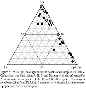
The feldspar content decreases toward the southeast. In contrast, the lithic fraction increases to the southeast. The modal abundance of heavy minerals also increases toward the southeast. The volcanic lithic fragments fraction is high at the D, E, F and G beach sites, as well as in the beach near the Armer&iacute;a river mouth basin (<a href="#f6">Figure 6</a>; <a href="/img/revistas/rmcg/v26n2/a13t3.jpg" target="_blank">Table 3</a>). Sedimentary lithics are not abundant in the studied beach sands (less than 5% of siltstone and limestone), despite the large area of limestone outcrops (<a href="/img/revistas/rmcg/v26n2/a13f1.jpg" target="_blank">Figure 1</a>, <a href="#t1">Table 1</a>).</font></p>     <p align="justify"><font face="verdana" size="2"><b>Geochemical data</b></font></p>     <p align="justify"><font face="verdana" size="2">Major elements like SiO<sub>2</sub>, TiO<sub>2</sub>, Fe<sub>2</sub>O<sub>3</sub> MnO, MgO and CaO exhibit in general high concentrations in southern beaches, mainly at sites I, J and K. Furthermore, it seems that TiO<sub>2</sub>, Fe<sub>2</sub>O<sub>3</sub> K<sub>2</sub>O, Na<sub>2</sub>O and Al<sub>2</sub>O<sub>3</sub> show significant variations at sites I, J, and K as it will be discussed further. </font></p>     <p align="justify"><font face="verdana" size="2">The CIA values for the studied beach sands slightly increase to the southeast (<a href="/img/revistas/rmcg/v26n2/a13t4.jpg" target="_blank">Table 4</a>), with the highest values corresponding to beaches I, J and K that belong to the Armer&iacute;a and Coahuayana river basins. </font></p>     <p align="justify"><font face="verdana" size="2">The SiO<sub>2</sub> content decreases to the southeast (<a href="/img/revistas/rmcg/v26n2/a13t4.jpg" target="_blank">Table 4</a>). There is an inverse correlation between Mz<img src="/img/revistas/rmcg/v26n2/a13s1.jpg">, Lp and K<sub>2</sub>O (<a href="/img/revistas/rmcg/v26n2/a13f7.jpg" target="_blank">Figure 7</a>). Diverse correlations between Lv, Lt, HM, SiO<sub>2</sub>, Lp and other major elements can be observed for the Colima beach sands (&#150;0.51 to 0.77). Furthermore significant positive correlations among TiO<sub>2</sub>, Fe<sub>2</sub>O<sub>3</sub>, V, Rb, Ba and K<sub>2</sub>O resulted with values ranging from 0.93 to 0.97. An increase of V, Cr, Co and Zn and a decrease of Ba, Sr and Rb southwards along the basin coast segments can also be observed (<a href="#t5">Table 5</a>). </font></p>     <p align="justify"><font face="verdana" size="2">&nbsp;</font></p>     <p align="justify"><font face="verdana" size="2"><b>DISCUSSION</b></font></p>     ]]></body>
<body><![CDATA[<p align="justify"><font face="verdana" size="2"><b>Grain size and beach profiles</b></font></p>     <p align="justify"><font face="verdana" size="2">Negative correlations between Mz<img src="/img/revistas/rmcg/v26n2/a13s1.jpg"> and &sigma;<img src="/img/revistas/rmcg/v26n2/a13s1.jpg"> in the beach sands have been also reported for beach sands in the eastern coast of the Gulf of California and dune sands in the Sonora Desert, Mexico (Carranza&#150;Edwards <i>et al.</i>, 1996; Kasper&#150;Zubillaga and Carranza&#150;Edwards, 2005), which suggest that fine sands are well sorted. This is mainly associated with the marine, fluvial and aeolian selectiveness that affect the sands and produce fine and well sorted sands in beach and dune sedimentary environments, due to hydraulic sorting of waves and winds respectively.</font></p>     <p align="justify"><font face="verdana" size="2">In the Cihuatl&aacute;n river basin, coarse grains are dominantly associated with small bays and cliffs in this area that constitutes a local source. In contrast, sediments in the Armer&iacute;a and Coahuayana river basins are exposed to a longer transport and a higher energy regime that enables the redistribution and selectiveness of sands. Sites A, B, C show heterogeneity in the grain size values whereas sites E and I show homogeneity in the grain size values. The rest of the sites have slight dissimilarities in their grain size values. </font></p>     <p align="justify"><font face="verdana" size="2">Differences in grain size values may be attributed to the open sea influence in sites E and I, where waves can originate well&#150;sorted, medium&#150;sized sands despite to the fact that the mouth of the Armer&iacute;a river is located close to the site where the sorting or the grain size characteristics are not affected. Besides, the grain size of discharges to the littoral tend to be fine in the Armer&iacute;a and Coahuayana river basins, where longer fluvial transport takes place. </font></p>     <p align="justify"><font face="verdana" size="2"><b>Detrital modal trends</b></font></p>     <p align="justify"><font face="verdana" size="2">The majority of the beach sands trend toward the Lt and Ft poles. However, the segment of the Cihuatl&aacute;n shows a higher content of Ft and Qz due to the influence of plutonic sources. The sediments of the Armer&iacute;a and Coahuayana river basins are associated with volcanic and sedimentary (mostly calcareous) rock sources, and most of these samples tend toward the Lt pole (<a href="#f5">Figure 5</a>). This interpretation is supported by the Lv&#150;Ls&#150;Lp+Lm plot diagram (<a href="#f6">Figure 6</a>) where the Cihuatl&aacute;n river basin samples are located toward the Lp+Lm pole, whereas the Armer&iacute;a and Coahuayana segments are near to the Lv pole and relatively far of the Ls pole, in spite of the great abundance of Ls sources (around 40% of the total area of that basins). </font></p>     <p align="justify"><font face="verdana" size="2">Feldspars are mostly composed of plagioclase derived from intermediate volcanic sources, as the content of Na<sub>2</sub>O is higher than K<sub>2</sub>O (<a href="/img/revistas/rmcg/v26n2/a13t4.jpg" target="_blank">Table 4</a>). Lithics are dominantly composed of volcanic and plutonic rocks, as shown in <a href="/img/revistas/rmcg/v26n2/a13t3.jpg" target="_blank">Table 3</a>. This is also supported by the Lv/Lp and Ls/Lp ratios (<a href="#t6">Table 6</a>). Volcanic rock fragments clearly dominate in the Armer&iacute;a and in the barrier beach of Cuyutl&aacute;n Lagoon (nourished by Coahuayana river (<a href="/img/revistas/rmcg/v26n2/a13t3.jpg" target="_blank">Table 3</a>). The trend of this barrier reflects the dominant transport toward the northwest, because the average longshore current velocities are 6 cm/s in winter and 9 cm/s in summer having southeastern and northwestern directions respectively (Fern&aacute;ndez&#150;Eguiarte <i>et al.</i>, 1992a, 1992b). The Lv&#150;Ls&#150;Lp+Lm plot (<a href="#f6">Figure 6</a>) is an evidence of the volcanic influence for the Armer&iacute;a and Coahuayana segments, and the Cihuatl&aacute;n segment shows an enrichment toward the Lp+Lm pole, being more abundant the Lp. </font></p>     <p align="justify"><font face="verdana" size="2">Armer&iacute;a and Coahuayana rivers do not supply potash feldspar as is revealed by the southward decrease in the feldspar content, whereas the Cihuatl&aacute;n beach segment shows a major content of feldspars that is related to the influence of plutonic sources. The barrier beach of Cuyutl&aacute;n Lagoon is constructed by the northwestern transport of fluvial sediments mainly from the Armer&iacute;a river. </font></p>     <p align="justify"><font face="verdana" size="2">The modal abundance of heavy minerals increases toward the Armer&iacute;a and Coahuayana river basins. This indicates that finer fractions concentrate heavy minerals, because they occur in areas of high wave energy. This condition occurs when the coarse grains are removed toward the offshore, leaving behind a fine&#150;grained heavy mineral deposit (Komar and Wang, 1984). Heavy mineral concentration near the Armer&iacute;a and Coahuayana river basins is likely associated with erosion of volcanic outcrops near the H to K sites (<a href="/img/revistas/rmcg/v26n2/a13t3.jpg" target="_blank">Table 3</a>). </font></p>     <p align="justify"><font face="verdana" size="2">Volcanic lithic fragments are preserved even in wave&#150;dominated coastal areas, supplied as fine&#150;grained volcanic fragments like those from the barrier beach across Cuyutl&aacute;n Lagoon, that initiate west of the Armer&iacute;a river mouth. In contrast, sedimentary lithic fragments are easily fragmented, and carbonate cement and limestone detritus are dissolved by chemical weathering in the source area and along the river, and mechanically reduced in wave&#150;dominated areas as in the Armer&iacute;a and Coahuayana river basins (<a href="/img/revistas/rmcg/v26n2/a13t3.jpg" target="_blank">Table 3</a>). This is observed in sites D, E, F, G, H and I, but not in sites J and K with fluvial influence of the Coahahuayana river that, although has a similar lithology of the adjacent Armer&iacute;a basin, has a relatively more extensive area affected by hot sub&#150;humid climate (<a href="#f2">Figure 2a</a>).</font></p>     ]]></body>
<body><![CDATA[<p align="justify"><font face="verdana" size="2">Feldspar content shows a peak at site B, which can be associated with a local source and the low abrasion effect of the grains in an area. The increase in feldspar content is also associated to the proximity of plutonic rocks (Lancin and Carranza&#150;Edwards, 1976) that occur only a few meters from the Bah&iacute;a de Santiago at the Cihuatl&aacute;n river basin (<a href="/img/revistas/rmcg/v26n2/a13f1.jpg" target="_blank">Figure 1</a>). Large modal abundance of plutonic fragments occur at sites A, B and C due to the influence of granitic rocks both in local drainages and along the Armer&iacute;a river basin. The negative correlation between plutonic lithic fragments and Mz<img src="/img/revistas/rmcg/v26n2/a13s1.jpg"> (<a href="/img/revistas/rmcg/v26n2/a13f7.jpg" target="_blank">Figure 7</a>) is related to coarser fractions (<a href="#t2">Table 2</a>) and plutonic detritus (<a href="/img/revistas/rmcg/v26n2/a13t3.jpg" target="_blank">Table 3</a>) as in the northwestern coast of the study area. </font></p>     <p align="justify"><font face="verdana" size="2">Sedimentary lithic fragments are sparse in the beach sands. This probably indicates the effect of high relief, humid climate and high wave energy in the beach environment depleted in sedimentary debris. </font></p>     <p align="justify"><font face="verdana" size="2"><b>Geochemistry of Colima beach sands</b></font></p>     <p align="justify"><font face="verdana" size="2"><i><b>Indicators of degree of weathering </b></i></font></p>     <p align="justify"><font face="verdana" size="2">Sand samples have CIA values from 59 to 73 as it can be seen in the A&#150;CN&#150;K diagram (<a href="#f8">Figure 8</a>) proposed by Nesbitt and Young (1982). The highest CIA values are observed for samples I1, J2 and K3, sites that belong to the Armer&iacute;a and Coahuayana segments. These can be explained by the extensive sub&#150;humid conditions (<a href="#f2">Figure 2a</a>) in the lower Coahuayana river basin, where samples have a low Lv content (<a href="/img/revistas/rmcg/v26n2/a13t3.jpg" target="_blank">Table 3</a>, <a href="#f6">Figure 6</a>), because of weathering of plagioclase contained in the volcanic rock fragments, even that sands influenced by high energy wave regimes are likely to produce low CIA values, as shown in previous studies (Rosales&#150;Hoz and Carranza&#150;Edwards, 1995), due to the removal of Al<sub>2</sub>O<sub>3</sub> in the superficial weathered envelope of feldspars in the beach environment related to humid basins. Furthermore, these samples also tend toward the A pole (<a href="#f8">Figure 8</a>) suggesting a higher degree of weathering indicated by the presence of higher Al<sub>2</sub>O<sub>3</sub> content.</font></p>     <p align="center"><font face="verdana" size="2"><a name="f8"></a></font></p>     <p align="center"><font face="verdana" size="2"><img src="/img/revistas/rmcg/v26n2/a13f8.jpg"></font></p>     <p align="justify"><font face="verdana" size="2">
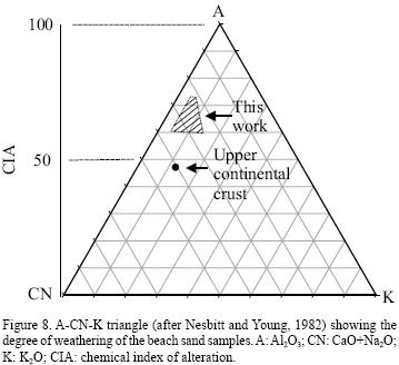
The increase in CIA values in beach sediments associated with the Armer&iacute;a and Coahuayana river basins (sites F, G, H, I, J and K) also suggests the influence of climate, because there is an extensive hot and very hot sub&#150;humid climatic sub&#150;zone (<a href="#f2">Figure 2a</a>) affecting the wheatering of the volcanic debris. The Coahuayana river (<a href="/img/revistas/rmcg/v26n2/a13f1.jpg" target="_blank">Figure 1</a>) flows through a wide, highly vegetated, low&#150;lying, inclined landscape (<a href="#f2">Figure 2b</a>) that contributes to the chemical weathering in the fluvial transported sediments, particularly in the low reaches of Coahuayana river.</font></p>     <p align="justify"><font face="verdana" size="2"><b>Provenance </b></font></p>     <p align="justify"><font face="verdana" size="2">The SiO<sub>2</sub> (and quartz) enrichment in the beaches of the Cihuatl&aacute;n basin (west segment) indicates that coarse grains are associated with plutonic fragments and quartz content. Plutonic lithic fragments are found in coarse detritus increasing the SiO<sub>2</sub> of beach sands from the sites A, B, C and D (Cihuatl&aacute;n segment). Moreover, there is an association between coarse grain sizes and the SiO<sub>2</sub> content in the bulk composition of the sands.The SiO<sub>2</sub> reflects primarily the abundance of leucocratic phases (quartz and feldspars) (Nesbitt and Young, 1996) in the beach sands of the Ciauhatlan western region. This is in agreement with the dominant granitic source rocks (<a href="/img/revistas/rmcg/v26n2/a13f1.jpg" target="_blank">Figure 1</a>). </font></p>     ]]></body>
<body><![CDATA[<p align="justify"><font face="verdana" size="2">The negative correlation between Mz<img src="/img/revistas/rmcg/v26n2/a13s1.jpg"> and K<sub>2</sub>O suggests that coarse grains are also composed of alkali feldspar and plutonic lithic fragments that contain potash feldspar, which increases the K<sub>2</sub>O content (<a href="/img/revistas/rmcg/v26n2/a13f7.jpg" target="_blank">Figure 7</a>). </font></p>     <p align="justify"><font face="verdana" size="2">On the other hand, the melanocratic phases (Fe&#150;Ti oxides) are contained in volcanic lithic fragments and they increase the abundances of TiO<sub>2</sub>, Fe<sub>2</sub>O<sub>3</sub> and MgO. Correlations among HM <i>versus</i> Lt, SiO<sub>2</sub>, TiO<sub>2</sub> and Fe<sub>2</sub>O<sub>3</sub> indicate that volcanic sources imprint the compositional signals observed in most of the analyzed beach sands (<a href="/img/revistas/rmcg/v26n2/a13f9.jpg" target="_blank">Figure 9</a>). </font></p>     <p align="justify"><font face="verdana" size="2">The average values of Fe<sub>2</sub>O<sub>3</sub>, MgO, CaO, and TiO<sub>2</sub> increase southward and are clearly related to volcanic debris supplied by the Armer&iacute;a and Coahuayana rivers (<a href="/img/revistas/rmcg/v26n2/a13f1.jpg" target="_blank">Figures 1</a> and <a href="/img/revistas/rmcg/v26n2/a13f10.jpg" target="_blank">10</a>, <a href="#t6">Table 6</a>). Furthermore, there are high Lv values associated with the barrier of Cuyutl&aacute;n Lagoon (<a href="/img/revistas/rmcg/v26n2/a13t3.jpg" target="_blank">Table 3</a>). In the mouth of Armer&iacute;a river the values are lower than those found in the barrier, because the initial discharge of fluvial sediments from Armer&iacute;a is concentrated toward northwest by the action of waves across the barrier where the dominant waves and alongshore drift increases Lv, related to the barrier beach of Cuyutl&aacute;n Lagoon (<a href="/img/revistas/rmcg/v26n2/a13t3.jpg" target="_blank">Table 3</a>). </font></p>     <p align="justify"><font face="verdana" size="2">The positive correlations among TiO<sub>2</sub>, Fe<sub>2</sub>O<sub>3</sub> and V shown in <a href="/img/revistas/rmcg/v26n2/a13f11.jpg" target="_blank">Figure 11</a> have been also reported for dune sands in the Sonora and Vizcaino Desert in Northwestern Mexico (Kasper&#150;Zubillaga and Zolezzi&#150;Ruiz, 2007), beach sands from the Gulf of Mexico and sands from the western coast of Mexico (Kasper&#150;Zubillaga <i>et al.</i>, 1999). Our results suggest that ilmenite and magnetite are contained in volcanic lithic fragments and in the HM fraction and they increase the abundances of TiO<sub>2</sub>, Fe<sub>2</sub>O<sub>3</sub> and V. </font></p>     <p align="justify"><font face="verdana" size="2">Regarding trace elements analyses, the average values of Ba, Sr and Rb decrease southwards (<a href="/img/revistas/rmcg/v26n2/a13f12.jpg" target="_blank">Figure 12</a>; <a href="#t5">Table 5</a>). Sr resides mainly in carbonate and feldspar (Yang <i>et al.</i>, 2003). High concentrations of Sr, mostly in the beach sands, may be a result of higher content of feldspar toward the Cihuatl&aacute;n segment (mainly in sites A, B, and C) (<a href="/img/revistas/rmcg/v26n2/a13t3.jpg" target="_blank">Table 3</a>). Rb and Ba may substitute for K in the lattice in K&#150;feldspar and mica (Muhs <i>et al.</i>, 2003). The correlations among Rb, Ba and K<sub>2</sub>O strongly suggest the presence of potash feldspar in the sands.</font></p>     <p align="justify"><font face="verdana" size="2">The correlation between TiO<sub>2</sub> and Fe<sub>2</sub>O<sub>3</sub> (<a href="/img/revistas/rmcg/v26n2/a13f11.jpg" target="_blank">Figure 11</a>) supports the presence in the sands of titanomagnetite or iron&#150;titanium oxides, which are common in intermediate and mafic volcanic rocks (Righter and Rosas&#150;Elguera, 2001, Mora <i>et al.</i>, 2002). The important sources of TiO<sub>2</sub> and Fe<sub>2</sub>O<sub>3</sub> are evident in the Armer&iacute;a and Coahuayana segments, which are Fe&#150;Ti enriched due mainly to the presence of volcanic rock fragments of andesitic nature (Vald&eacute;z&#150;Moreno <i>et al.</i>, 2006).</font></p>     <p align="justify"><font face="verdana" size="2">An increase of K<sub>2</sub>O with Rb and Ba content is observed in the sediments as shown in the correlation plots (<a href="/img/revistas/rmcg/v26n2/a13f11.jpg" target="_blank">Figure 11</a>). This implies that the sands in the northwest segment have been more influenced in their Ba, Sr and Rb contents by granitic sources (<a href="/img/revistas/rmcg/v26n2/a13f11.jpg" target="_blank">Figures 11</a> and <a href="/img/revistas/rmcg/v26n2/a13f12.jpg" target="_blank">12</a>) associated with non&#150;weathered K&#150;feldspar and biotite.</font></p>     <p align="justify"><font face="verdana" size="2"><i><b>Normalized patterns of major and trace elements</b></i></font></p>     <p align="justify"><font face="verdana" size="2">Trace elements abundances were normalized to the Upper Continental Crust (UCC) values reported by Taylor and MacLennan (1985) and McLennan (1995). The most notorious trends are given by the average values of each site. A decrease in the SiO<sub>2</sub>, Al<sub>2</sub>O<sub>3</sub>, Na<sub>2</sub>O, and K<sub>2</sub>O contents and an increase in the Fe<sub>2</sub>O<sub>3</sub>, CaO, MgO, TiO<sub>2</sub>  contents is observed from the western (Cihuatl&aacute;n) to the eastern (Coahuayana) segments (<a href="/img/revistas/rmcg/v26n2/a13f10.jpg" target="_blank">Figure 10</a>).</font></p>     <p align="justify"><font face="verdana" size="2">The influence of plutonic rocks in the Cihuatl&aacute;n basin is also reflected by the average of the normalized trace elements Ba, Sr and Rb. In contrast, the increase in V, Cr, Co and Zn indicates a volcanic input from the Armer&iacute;a and Coahuayana basins (<a href="/img/revistas/rmcg/v26n2/a13f12.jpg" target="_blank">Figure 12</a>). This interpretation is supported by the relative increase of Lv/Qt, Lv/Ft and Lv/Lp ratios in the Armer&iacute;a and Coahuayana segments (<a href="/img/revistas/rmcg/v26n2/a13t3.jpg" target="_blank">Tables 3</a> and <a href="/img/revistas/rmcg/v26n2/a13t4.jpg" target="_blank">4</a>).</font></p>     ]]></body>
<body><![CDATA[<p align="justify"><font face="verdana" size="2">&nbsp;</font></p>     <p align="justify"><font face="verdana" size="2"><b>CONCLUSIONS</b></font></p>     <p align="justify"><font face="verdana" size="2">The beaches of the Cihuatl&aacute;n basin tend to be narrower compared to those of the Armer&iacute;a and Coahuayana basins. Coarse and poorly sorted sediments are present in the Cihuatl&aacute;n basin, which is probably related to less removal of coarse grains associated to shorter transport and less wave effect. The Armer&iacute;a and Coahuayana beach segments show similar grain size patterns, being fine grained and better sorted sands. </font></p>     <p align="justify"><font face="verdana" size="2">Sands of the Coahuayana river basin are controlled by plutonic and volcanic sources. An increase in feldspar content in the Cihuatl&aacute;n river basin is likely generated from larger plutonic sources. Heavy minerals concentration increases toward the influence area of the Armer&iacute;a and Coahuayana rivers, where fine fractions are observed in the beach sands. Beaches from the Cihuatl&aacute;n basin segment are dominantly influenced by granitoides. In contrast, the Armer&iacute;a and Coahuayana segments are mostly influenced by volcanic sources. </font></p>     <p align="justify"><font face="verdana" size="2">The Coahuayana river basins has around 40 % of exposure limestone outcrops, however the final result of sedimentary lithics content in beach sands is less than 6 % and almost non&#150;existant in the Armer&iacute;a segment. This may be due to intense chemical weathering of limestone in soil and during transport, as well as to low resistance of limestone under high energy river&#150;marine conditions. </font></p>     <p align="justify"><font face="verdana" size="2">The chemical index of alteration (CIA) values increases toward the Armer&iacute;a and Coahuayana segments near the river mouth, which is probably due to an increase in weathered volcanic rock fragments related to a more extensive area with humid conditions. </font></p>     <p align="justify"><font face="verdana" size="2">The influence of plutonic rocks in the Cihuatl&aacute;n segment is reflected by the high values of Si, Al, Na, K, Ba, Sr and Rb. The increase of Fe, Ca, Mg, Ti, V, Cr, Co and Zn in beach segments closer to the Armer&iacute;a and Coahuayana rivers is controlled mostly by volcanic rock fragments provenance. </font></p>     <p align="justify"><font face="verdana" size="2">&nbsp;</font></p>     <p align="justify"><font face="verdana" size="2"><b>ACKNOWLEDGEMENTS</b></font></p>     <p align="justify"><font face="verdana" size="2">We appreciated the support given by the authorities from the Instituto de Ciencias del Mar y Limnolog&iacute;a and the Instituto de Geolog&iacute;a, both from the Universidad Nacional Aut&oacute;noma de M&eacute;xico (UNAM). We apprecciated the comments made to the manuscript by Dr. Arturo Martin Barajas, Dr. Madhavaraju Jayagopal, Dr. Walter Daessl&eacute; and Dr. Jos&eacute; A. Jim&eacute;nez and to Ana Marin Guzman for her help in improving the draws. </font></p>     ]]></body>
<body><![CDATA[<p align="justify"><font face="verdana" size="2">&nbsp;</font></p>     <p align="justify"><font face="verdana" size="2"><b>REFERENCES</b></font></p>     <!-- ref --><p align="justify"><font face="verdana" size="2">Bird, E., 2000, Coastal Geomorphology: An Introduction, Chichester, England, John Wiley &amp; Sons, Ltd., 322 pp. </font>&nbsp;&nbsp;&nbsp;&nbsp;&nbsp;&nbsp;&nbsp;&nbsp;[&#160;<a href="javascript:void(0);" onclick="javascript: window.open('/scielo.php?script=sci_nlinks&ref=8036432&pid=S1026-8774200900020001300001&lng=','','width=640,height=500,resizable=yes,scrollbars=1,menubar=yes,');">Links</a>&#160;]<!-- end-ref --><!-- ref --><p align="justify"><font face="verdana" size="2">Campos&#150;Enr&iacute;quez, O., Alatorre&#150;Zamora, M.A., 1998, Shallow crustal structure of the northern portion of the junction of the grabens of Chapala, Tepic&#150;Zacoalco and Colima, M&eacute;xico: Geof&iacute;sica Internacional, 37, 263&#150;282. </font>&nbsp;&nbsp;&nbsp;&nbsp;&nbsp;&nbsp;&nbsp;&nbsp;[&#160;<a href="javascript:void(0);" onclick="javascript: window.open('/scielo.php?script=sci_nlinks&ref=8036433&pid=S1026-8774200900020001300002&lng=','','width=640,height=500,resizable=yes,scrollbars=1,menubar=yes,');">Links</a>&#160;]<!-- end-ref --><!-- ref --><p align="justify"><font face="verdana" size="2">Carranza&#150;Edwards, A., 2001, Grain size and sorting in modern beach sands: Journal of Coastal Research, 17(1), 38&#150;52. </font>&nbsp;&nbsp;&nbsp;&nbsp;&nbsp;&nbsp;&nbsp;&nbsp;[&#160;<a href="javascript:void(0);" onclick="javascript: window.open('/scielo.php?script=sci_nlinks&ref=8036434&pid=S1026-8774200900020001300003&lng=','','width=640,height=500,resizable=yes,scrollbars=1,menubar=yes,');">Links</a>&#160;]<!-- end-ref --><!-- ref --><p align="justify"><font face="verdana" size="2">Carranza&#150;Edwards, A., Rosales&#150;Hoz, L., 1995, Grain&#150;size trends and provenance of southwestern Gulf of Mexico beach sands: Canadian Journal of Earth Sciences, 32(12), 2009&#150;2014. doi:10.1139/e95&#150;153&nbsp;</font>&nbsp;&nbsp;&nbsp;&nbsp;&nbsp;&nbsp;&nbsp;&nbsp;[&#160;<a href="javascript:void(0);" onclick="javascript: window.open('/scielo.php?script=sci_nlinks&ref=8036435&pid=S1026-8774200900020001300004&lng=','','width=640,height=500,resizable=yes,scrollbars=1,menubar=yes,');">Links</a>&#160;]<!-- end-ref --><!-- ref --><p align="justify"><font face="verdana" size="2">Carranza&#150;Edwards, A., Rosales&#150;Hoz, L., Santiago&#150;P&eacute;rez, S., 1994, Provenance memories and maturity of holocene sands in Northwest Mexico: Canadian. Journal of. Earth Science, 31(10), 1550&#150;1556.</font>&nbsp;&nbsp;&nbsp;&nbsp;&nbsp;&nbsp;&nbsp;&nbsp;[&#160;<a href="javascript:void(0);" onclick="javascript: window.open('/scielo.php?script=sci_nlinks&ref=8036436&pid=S1026-8774200900020001300005&lng=','','width=640,height=500,resizable=yes,scrollbars=1,menubar=yes,');">Links</a>&#160;]<!-- end-ref --><!-- ref --><p align="justify"><font face="verdana" size="2">Carranza&#150;Edwards, A., Bocanegra&#150;Garc&iacute;a, G., Rosales&#150;Hoz, L., De Pablo Gal&aacute;n, L., 1996,. Beach sands from Baja California Peninsula, Mexico: Sedimentary Geology, 119, 263&#150;274.</font>&nbsp;&nbsp;&nbsp;&nbsp;&nbsp;&nbsp;&nbsp;&nbsp;[&#160;<a href="javascript:void(0);" onclick="javascript: window.open('/scielo.php?script=sci_nlinks&ref=8036437&pid=S1026-8774200900020001300006&lng=','','width=640,height=500,resizable=yes,scrollbars=1,menubar=yes,');">Links</a>&#160;]<!-- end-ref --><!-- ref --><p align="justify"><font face="verdana" size="2">Fern&aacute;ndez&#150;Eguiarte, A., Gallegos&#150;Garc&iacute;a, A., Zavala&#150;Hidalgo, J., 1992a, Oceanograf&iacute;a F&iacute;sica 1 (Masas de Agua y Mareas de los Mares Mexicanos), Hoja IV.9.1, Verano, scale 1:4,000,000, in Atlas Nacional de M&eacute;xico, Tomo II, IV. Naturaleza, 9. Oceanograf&iacute;a F&iacute;sica: M&eacute;xico, D.F., Universidad Nacional Aut&oacute;noma de M&eacute;xico, Instituto de Geograf&iacute;a, 1 map.</font>&nbsp;&nbsp;&nbsp;&nbsp;&nbsp;&nbsp;&nbsp;&nbsp;[&#160;<a href="javascript:void(0);" onclick="javascript: window.open('/scielo.php?script=sci_nlinks&ref=8036438&pid=S1026-8774200900020001300007&lng=','','width=640,height=500,resizable=yes,scrollbars=1,menubar=yes,');">Links</a>&#160;]<!-- end-ref --><!-- ref --><p align="justify"><font face="verdana" size="2">Fern&aacute;ndez&#150;Eguiarte, A., Gallegos&#150;Garc&iacute;a, A., Zavala&#150;Hidalgo, J., 1992b, Oceanograf&iacute;a F&iacute;sica 1 (Masas de Agua y Mareas de los Mares Mexicanos), Hoja IV.9.2, Invierno, scale 1:4,000,000 <i>in</i> Atlas Nacional de M&eacute;xico, Tomo II, IV. Naturaleza, 9. Oceanograf&iacute;a F&iacute;sica: M&eacute;xico, D.F., Universidad Nacional Aut&oacute;noma de M&eacute;xico, Instituto de Geograf&iacute;a, 1 map.</font>&nbsp;&nbsp;&nbsp;&nbsp;&nbsp;&nbsp;&nbsp;&nbsp;[&#160;<a href="javascript:void(0);" onclick="javascript: window.open('/scielo.php?script=sci_nlinks&ref=8036439&pid=S1026-8774200900020001300008&lng=','','width=640,height=500,resizable=yes,scrollbars=1,menubar=yes,');">Links</a>&#160;]<!-- end-ref --><!-- ref --><p align="justify"><font face="verdana" size="2">Folk, R.L., 1974, Petrology of Sedimentary Rocks: Austin, Texas, Hemphill Publishing Co, 182 pp.</font>&nbsp;&nbsp;&nbsp;&nbsp;&nbsp;&nbsp;&nbsp;&nbsp;[&#160;<a href="javascript:void(0);" onclick="javascript: window.open('/scielo.php?script=sci_nlinks&ref=8036440&pid=S1026-8774200900020001300009&lng=','','width=640,height=500,resizable=yes,scrollbars=1,menubar=yes,');">Links</a>&#160;]<!-- end-ref --><!-- ref --><p align="justify"><font face="verdana" size="2">Franzinelli, E., Potter, P.E., 1983, Petrology, chemistry and texture of modern river sands, Amazon River System: Journal of Geology, 91, 23&#150;29.</font>&nbsp;&nbsp;&nbsp;&nbsp;&nbsp;&nbsp;&nbsp;&nbsp;[&#160;<a href="javascript:void(0);" onclick="javascript: window.open('/scielo.php?script=sci_nlinks&ref=8036441&pid=S1026-8774200900020001300010&lng=','','width=640,height=500,resizable=yes,scrollbars=1,menubar=yes,');">Links</a>&#160;]<!-- end-ref --><!-- ref --><p align="justify"><font face="verdana" size="2">Garc&iacute;a, E., 1990, Climas, Hoja IV.4.10, escale 1:4,000,000, <i>in</i> Atlas Nacional de M&eacute;xico, Tomo II, IV. Naturaleza, 4. Clima: M&eacute;xico, D.F., Universidad Nacional Aut&oacute;noma de M&eacute;xico, Instituto de Geograf&iacute;a, 1 map.</font>&nbsp;&nbsp;&nbsp;&nbsp;&nbsp;&nbsp;&nbsp;&nbsp;[&#160;<a href="javascript:void(0);" onclick="javascript: window.open('/scielo.php?script=sci_nlinks&ref=8036442&pid=S1026-8774200900020001300011&lng=','','width=640,height=500,resizable=yes,scrollbars=1,menubar=yes,');">Links</a>&#160;]<!-- end-ref --><!-- ref --><p align="justify"><font face="verdana" size="2">Honda, M., Shimizu, H., 1998, Geochemical, mineralogical and sedimentological studies on the Taklimakan Desert sands: Sedimentology, 45, 1125&#150;1143.</font>&nbsp;&nbsp;&nbsp;&nbsp;&nbsp;&nbsp;&nbsp;&nbsp;[&#160;<a href="javascript:void(0);" onclick="javascript: window.open('/scielo.php?script=sci_nlinks&ref=8036443&pid=S1026-8774200900020001300012&lng=','','width=640,height=500,resizable=yes,scrollbars=1,menubar=yes,');">Links</a>&#160;]<!-- end-ref --><!-- ref --><p align="justify"><font face="verdana" size="2">Ibbeken, H., Schleyer, R., 1991, Source and Sediment: Berlin, Springer&#150;Verlag, 286 pp.</font>&nbsp;&nbsp;&nbsp;&nbsp;&nbsp;&nbsp;&nbsp;&nbsp;[&#160;<a href="javascript:void(0);" onclick="javascript: window.open('/scielo.php?script=sci_nlinks&ref=8036444&pid=S1026-8774200900020001300013&lng=','','width=640,height=500,resizable=yes,scrollbars=1,menubar=yes,');">Links</a>&#160;]<!-- end-ref --><!-- ref --><p align="justify"><font face="verdana" size="2">Instituto Nacional de Estad&iacute;stica, Geograf&iacute;a e Inform&aacute;tica (INEGI), Lugo&#150;Hupb, J., Vidal&#150;Zepeda, R., Fern&aacute;ndez&#150;Eguiarte, A., Gallegos&#150;Garc&iacute;a, A. Zavala&#150;Hidalgo, J., 1990, Hipsometr&iacute;a y batimetr&iacute;a, Hoja I.1.1, escala 1:4,000,000, <i>in</i> Atlas Nacional de M&eacute;xico, Tomo I, 1. Mapas Generales: M&eacute;xico, D.F., Universidad Nacional Aut&oacute;noma de M&eacute;xico, Instituto de Geograf&iacute;a, 1 map.</font>&nbsp;&nbsp;&nbsp;&nbsp;&nbsp;&nbsp;&nbsp;&nbsp;[&#160;<a href="javascript:void(0);" onclick="javascript: window.open('/scielo.php?script=sci_nlinks&ref=8036445&pid=S1026-8774200900020001300014&lng=','','width=640,height=500,resizable=yes,scrollbars=1,menubar=yes,');">Links</a>&#160;]<!-- end-ref --><!-- ref --><p align="justify"><font face="verdana" size="2">Kasper&#150;Zubillaga, J.J., Carranza Edwards, A., 2005, Grain size discrimination between sands of desert and coastal dunes from northwest Mexico: Revista Mexicana de Ciencias Geol&oacute;gicas, 22(3), 383&#150;390. </font>&nbsp;&nbsp;&nbsp;&nbsp;&nbsp;&nbsp;&nbsp;&nbsp;[&#160;<a href="javascript:void(0);" onclick="javascript: window.open('/scielo.php?script=sci_nlinks&ref=8036446&pid=S1026-8774200900020001300015&lng=','','width=640,height=500,resizable=yes,scrollbars=1,menubar=yes,');">Links</a>&#160;]<!-- end-ref --><!-- ref --><p align="justify"><font face="verdana" size="2">Kasper&#150;Zubillaga, J.J., Zolezzi&#150;Ruiz, H., 2007, Grain size, mineralogical and geochemical studies of coastal and inland dune sands from El Vizca&iacute;no Desert, Baja California Peninsula, Mexico: Revista Mexicana de Ciencias Geol&oacute;gicas, 24(3), 423&#150;438. </font>&nbsp;&nbsp;&nbsp;&nbsp;&nbsp;&nbsp;&nbsp;&nbsp;[&#160;<a href="javascript:void(0);" onclick="javascript: window.open('/scielo.php?script=sci_nlinks&ref=8036447&pid=S1026-8774200900020001300016&lng=','','width=640,height=500,resizable=yes,scrollbars=1,menubar=yes,');">Links</a>&#160;]<!-- end-ref --><!-- ref --><p align="justify"><font face="verdana" size="2">Kasper&#150;Zubillaga, J.J., Carranza&#150;Edwards, A., Rosales&#150;Hoz, L., 1999, Petrography and geochemistry of Holocene sands in the western Gulf of M&eacute;xico: implications of provenance and tectonic setting: Journal of Sedimentary Research, 69(5), 1003&#150;1010.</font>&nbsp;&nbsp;&nbsp;&nbsp;&nbsp;&nbsp;&nbsp;&nbsp;[&#160;<a href="javascript:void(0);" onclick="javascript: window.open('/scielo.php?script=sci_nlinks&ref=8036448&pid=S1026-8774200900020001300017&lng=','','width=640,height=500,resizable=yes,scrollbars=1,menubar=yes,');">Links</a>&#160;]<!-- end-ref --><!-- ref --><p align="justify"><font face="verdana" size="2">Klitgord, K.D., Mammerickx, J., 1982, Northern East Pacific Rise: magnetic anomaly and bathymetric framework: Journal of Geophysical Research, 87(B8), 6725&#150;6750. </font>&nbsp;&nbsp;&nbsp;&nbsp;&nbsp;&nbsp;&nbsp;&nbsp;[&#160;<a href="javascript:void(0);" onclick="javascript: window.open('/scielo.php?script=sci_nlinks&ref=8036449&pid=S1026-8774200900020001300018&lng=','','width=640,height=500,resizable=yes,scrollbars=1,menubar=yes,');">Links</a>&#160;]<!-- end-ref --><!-- ref --><p align="justify"><font face="verdana" size="2">Komar, P.D., 1976, Beach Processes and Sedimentation: New Jersey, Prentice&#150;Hall, 429 pp. </font>&nbsp;&nbsp;&nbsp;&nbsp;&nbsp;&nbsp;&nbsp;&nbsp;[&#160;<a href="javascript:void(0);" onclick="javascript: window.open('/scielo.php?script=sci_nlinks&ref=8036450&pid=S1026-8774200900020001300019&lng=','','width=640,height=500,resizable=yes,scrollbars=1,menubar=yes,');">Links</a>&#160;]<!-- end-ref --><!-- ref --><p align="justify"><font face="verdana" size="2">Komar, P.D., Wang, C., 1984, Processes of selective grain transport and the formation of placers on beaches: Journal of Geology, 92, 637&#150;655.</font>&nbsp;&nbsp;&nbsp;&nbsp;&nbsp;&nbsp;&nbsp;&nbsp;[&#160;<a href="javascript:void(0);" onclick="javascript: window.open('/scielo.php?script=sci_nlinks&ref=8036451&pid=S1026-8774200900020001300020&lng=','','width=640,height=500,resizable=yes,scrollbars=1,menubar=yes,');">Links</a>&#160;]<!-- end-ref --><!-- ref --><p align="justify"><font face="verdana" size="2">Lancin, M., Carranza, A., 1976, Estudio geomorfol&oacute;gico de la Bah&iacute;a y de la Playa de Santiago en Manzanillo, Colima: Revista del Instituto Geolog&iacute;a, Universidad Nacional Aut&oacute;noma M&eacute;xico, 2, 43&#150;65.</font>&nbsp;&nbsp;&nbsp;&nbsp;&nbsp;&nbsp;&nbsp;&nbsp;[&#160;<a href="javascript:void(0);" onclick="javascript: window.open('/scielo.php?script=sci_nlinks&ref=8036452&pid=S1026-8774200900020001300021&lng=','','width=640,height=500,resizable=yes,scrollbars=1,menubar=yes,');">Links</a>&#160;]<!-- end-ref --><!-- ref --><p align="justify"><font face="verdana" size="2">Le Pera, E., Critelli, S., 1997, Sourceland controls on the composition of beach and fluvial sand of the northern Tyrrhenian coast of Calabria, Italy: implications for actualistic petrofacies: Journal of Sedimentary Research, 110(1&#150;2), 81&#150;97. </font>&nbsp;&nbsp;&nbsp;&nbsp;&nbsp;&nbsp;&nbsp;&nbsp;[&#160;<a href="javascript:void(0);" onclick="javascript: window.open('/scielo.php?script=sci_nlinks&ref=8036453&pid=S1026-8774200900020001300022&lng=','','width=640,height=500,resizable=yes,scrollbars=1,menubar=yes,');">Links</a>&#160;]<!-- end-ref --><!-- ref --><p align="justify"><font face="verdana" size="2">Lozano, R., Bernal, J.P., 2005, Characterization of a new set of eight geochemical reference materials for XRF major and trace element analysis: Revista Mexicana de Ciencias Geol&oacute;gicas, 22(3), 329&#150;344.</font>&nbsp;&nbsp;&nbsp;&nbsp;&nbsp;&nbsp;&nbsp;&nbsp;[&#160;<a href="javascript:void(0);" onclick="javascript: window.open('/scielo.php?script=sci_nlinks&ref=8036454&pid=S1026-8774200900020001300023&lng=','','width=640,height=500,resizable=yes,scrollbars=1,menubar=yes,');">Links</a>&#160;]<!-- end-ref --><!-- ref --><p align="justify"><font face="verdana" size="2">Luhr, J.F., Nelson, S.A., Allan, J.F., Carmichael, I.S.E., 1985, Active rifting in southwestern Mexico: Manifestation of an incipient eastward spreading&#150;ridge jump: Geology 13(1), 54&#150;57. </font>&nbsp;&nbsp;&nbsp;&nbsp;&nbsp;&nbsp;&nbsp;&nbsp;[&#160;<a href="javascript:void(0);" onclick="javascript: window.open('/scielo.php?script=sci_nlinks&ref=8036455&pid=S1026-8774200900020001300024&lng=','','width=640,height=500,resizable=yes,scrollbars=1,menubar=yes,');">Links</a>&#160;]<!-- end-ref --><!-- ref --><p align="justify"><font face="verdana" size="2">McLennan, S.M., 1995, Sediments and Soils: chemistry and abundances, <i>in</i> Ahrens, T.J. (ed.), Rock Physics and Phase Relations. A Handbook of Physical Constants: Washington, D.C., American Geophysical Union, Reference Shelf 3, 8&#150;19 p. </font>&nbsp;&nbsp;&nbsp;&nbsp;&nbsp;&nbsp;&nbsp;&nbsp;[&#160;<a href="javascript:void(0);" onclick="javascript: window.open('/scielo.php?script=sci_nlinks&ref=8036456&pid=S1026-8774200900020001300025&lng=','','width=640,height=500,resizable=yes,scrollbars=1,menubar=yes,');">Links</a>&#160;]<!-- end-ref --><!-- ref --><p align="justify"><font face="verdana" size="2">Mora, J.C., Mac&iacute;as, J.L., Saucedo, R., Orlando, A., Manetti, P., Vaselli, O., 2002, Petrology of the 1998&#150;2000 products of Volcano de Colima: Journal of Volcanology and Geothermal Research, 117(1&#150;2), 195&#150;212.</font>&nbsp;&nbsp;&nbsp;&nbsp;&nbsp;&nbsp;&nbsp;&nbsp;[&#160;<a href="javascript:void(0);" onclick="javascript: window.open('/scielo.php?script=sci_nlinks&ref=8036457&pid=S1026-8774200900020001300026&lng=','','width=640,height=500,resizable=yes,scrollbars=1,menubar=yes,');">Links</a>&#160;]<!-- end-ref --><!-- ref --><p align="justify"><font face="verdana" size="2">Muhs, D.R., Reynolds, R.L., Been, J., Skipp, G., 2003, Eolian sand transport pathways in the southwestern United States: Importance of the Colorado River and local sources: Quaternary International, 104, 3&#150;18.</font>&nbsp;&nbsp;&nbsp;&nbsp;&nbsp;&nbsp;&nbsp;&nbsp;[&#160;<a href="javascript:void(0);" onclick="javascript: window.open('/scielo.php?script=sci_nlinks&ref=8036458&pid=S1026-8774200900020001300027&lng=','','width=640,height=500,resizable=yes,scrollbars=1,menubar=yes,');">Links</a>&#160;]<!-- end-ref --><!-- ref --><p align="justify"><font face="verdana" size="2">Nesbitt, H.W., Young, G.M., 1982, Early Proterozoic climates and plate motions inferred from major element chemistry of lutites: Nature, 299, 715&#150;717. </font>&nbsp;&nbsp;&nbsp;&nbsp;&nbsp;&nbsp;&nbsp;&nbsp;[&#160;<a href="javascript:void(0);" onclick="javascript: window.open('/scielo.php?script=sci_nlinks&ref=8036459&pid=S1026-8774200900020001300028&lng=','','width=640,height=500,resizable=yes,scrollbars=1,menubar=yes,');">Links</a>&#160;]<!-- end-ref --><!-- ref --><p align="justify"><font face="verdana" size="2">Nesbitt, H.W., Young, G.M., 1996, Petrogenesis of sediments in the absence of chemical weathering: effects of abrasion and sorting on bulk composition and mineralogy: Sedimentology, 43, 341&#150;358.</font>&nbsp;&nbsp;&nbsp;&nbsp;&nbsp;&nbsp;&nbsp;&nbsp;[&#160;<a href="javascript:void(0);" onclick="javascript: window.open('/scielo.php?script=sci_nlinks&ref=8036460&pid=S1026-8774200900020001300029&lng=','','width=640,height=500,resizable=yes,scrollbars=1,menubar=yes,');">Links</a>&#160;]<!-- end-ref --><!-- ref --><p align="justify"><font face="verdana" size="2">Ortega&#150;Guti&eacute;rrez, F., Mitre&#150;Salazar, L.M., Rold&aacute;n&#150;Quintana, J., Aranda&#150;G&oacute;mez, J.J, Mor&aacute;n&#150; Zenteno, D., Nieto&#150;Samaniego, A., 1992, Carta Geol&oacute;gica de la Rep&uacute;blica Mexicana, scale 1:2,000,000: M&eacute;xico, D.F., Universidad Nacional Aut&oacute;noma de M&eacute;xico, Instituto de Geolog&iacute;a, 1 map.</font>&nbsp;&nbsp;&nbsp;&nbsp;&nbsp;&nbsp;&nbsp;&nbsp;[&#160;<a href="javascript:void(0);" onclick="javascript: window.open('/scielo.php?script=sci_nlinks&ref=8036461&pid=S1026-8774200900020001300030&lng=','','width=640,height=500,resizable=yes,scrollbars=1,menubar=yes,');">Links</a>&#160;]<!-- end-ref --><!-- ref --><p align="justify"><font face="verdana" size="2">Padilla y S&aacute;nchez, R. J., Aceves&#150;Quesada, J.F., 1990, Geolog&iacute;a, Hoja IV.1.1, escala 1:4, 000,000, <i>in</i> Atlas Nacional de M&eacute;xico, Tomo II, IV. Naturaleza, 1. Geolog&iacute;a: M&eacute;xico, D.F., Universidad Nacional Aut&oacute;noma de M&eacute;xico, Instituto de Geograf&iacute;a, 1 map.</font>&nbsp;&nbsp;&nbsp;&nbsp;&nbsp;&nbsp;&nbsp;&nbsp;[&#160;<a href="javascript:void(0);" onclick="javascript: window.open('/scielo.php?script=sci_nlinks&ref=8036462&pid=S1026-8774200900020001300031&lng=','','width=640,height=500,resizable=yes,scrollbars=1,menubar=yes,');">Links</a>&#160;]<!-- end-ref --><!-- ref --><p align="justify"><font face="verdana" size="2">Righter, K., Rosas&#150;Elguera, J., 2001, Alkaline Lavas in the Volcanic Front of the Western Mexican Volcanic Belt: Geology and Petrology of the Ayutla and Tapalpa Volcanic Fields: Journal Petrology, 42(12), 2333&#150;2361. </font>&nbsp;&nbsp;&nbsp;&nbsp;&nbsp;&nbsp;&nbsp;&nbsp;[&#160;<a href="javascript:void(0);" onclick="javascript: window.open('/scielo.php?script=sci_nlinks&ref=8036463&pid=S1026-8774200900020001300032&lng=','','width=640,height=500,resizable=yes,scrollbars=1,menubar=yes,');">Links</a>&#160;]<!-- end-ref --><!-- ref --><p align="justify"><font face="verdana" size="2">Rosales&#150;Hoz, L., Carranza&#150;Edwards, A., 1995, Geochemistry of two Mexican tropical basins in an active margin and their influence on littoral sediments: Journal of South American Earth Sciences, 8(2): 221&#150;228. </font>&nbsp;&nbsp;&nbsp;&nbsp;&nbsp;&nbsp;&nbsp;&nbsp;[&#160;<a href="javascript:void(0);" onclick="javascript: window.open('/scielo.php?script=sci_nlinks&ref=8036464&pid=S1026-8774200900020001300033&lng=','','width=640,height=500,resizable=yes,scrollbars=1,menubar=yes,');">Links</a>&#160;]<!-- end-ref --><!-- ref --><p align="justify"><font face="verdana" size="2">Stock, J.M., 1993, Tect&oacute;nica de placas y la evoluci&oacute;n geol&oacute;gica del bloque Jalisco, M&eacute;xico: GEOS, 13(3), 3&#150;9.</font>&nbsp;&nbsp;&nbsp;&nbsp;&nbsp;&nbsp;&nbsp;&nbsp;[&#160;<a href="javascript:void(0);" onclick="javascript: window.open('/scielo.php?script=sci_nlinks&ref=8036465&pid=S1026-8774200900020001300034&lng=','','width=640,height=500,resizable=yes,scrollbars=1,menubar=yes,');">Links</a>&#160;]<!-- end-ref --><!-- ref --><p align="justify"><font face="verdana" size="2">Tamayo, J.L., 2002, Geograf&iacute;a Moderna de M&eacute;xico: M&eacute;xico, Editorial Trillas, S.A, 512 pp.</font>&nbsp;&nbsp;&nbsp;&nbsp;&nbsp;&nbsp;&nbsp;&nbsp;[&#160;<a href="javascript:void(0);" onclick="javascript: window.open('/scielo.php?script=sci_nlinks&ref=8036466&pid=S1026-8774200900020001300035&lng=','','width=640,height=500,resizable=yes,scrollbars=1,menubar=yes,');">Links</a>&#160;]<!-- end-ref --><!-- ref --><p align="justify"><font face="verdana" size="2">Taylor, S.R., McLennan, S.M., 1985, The Continental Crust: its composition and evolution: United Kingdom, Blackwell Oxford, 349 pp. </font>&nbsp;&nbsp;&nbsp;&nbsp;&nbsp;&nbsp;&nbsp;&nbsp;[&#160;<a href="javascript:void(0);" onclick="javascript: window.open('/scielo.php?script=sci_nlinks&ref=8036467&pid=S1026-8774200900020001300036&lng=','','width=640,height=500,resizable=yes,scrollbars=1,menubar=yes,');">Links</a>&#160;]<!-- end-ref --><!-- ref --><p align="justify"><font face="verdana" size="2">Valdez&#150;Moreno, G., Schaaf, P., Mac&iacute;as, J.L., Kusakabe, M., 2006, New Sr&#150;Nd&#150;Pb&#150;O isotopedata for Colima volcano and evidence for the nature of the local basement, <i>in</i> Siebe, C., Mac&iacute;as, J.L., Aguirre&#150;D&iacute;az, G.J. (eds.), Neogene&#150;Quaternary Continental Margin Vulcanism: a persective from Mexico: Geological Society of America, Special Paper 402, 45&#150;63</font>&nbsp;&nbsp;&nbsp;&nbsp;&nbsp;&nbsp;&nbsp;&nbsp;[&#160;<a href="javascript:void(0);" onclick="javascript: window.open('/scielo.php?script=sci_nlinks&ref=8036468&pid=S1026-8774200900020001300037&lng=','','width=640,height=500,resizable=yes,scrollbars=1,menubar=yes,');">Links</a>&#160;]<!-- end-ref --><!-- ref --><p align="justify"><font face="verdana" size="2">Verma, S.P., Luhr, J., 1993, Sr&#150;Nd&#150;Pb isotope and trace element geochemistry of Calc&#150;alkaline andesites from Volcano of Colima, Mexico: Geof&iacute;sica Internacional, 32(4), 617&#150;631.</font>&nbsp;&nbsp;&nbsp;&nbsp;&nbsp;&nbsp;&nbsp;&nbsp;[&#160;<a href="javascript:void(0);" onclick="javascript: window.open('/scielo.php?script=sci_nlinks&ref=8036469&pid=S1026-8774200900020001300038&lng=','','width=640,height=500,resizable=yes,scrollbars=1,menubar=yes,');">Links</a>&#160;]<!-- end-ref --><!-- ref --><p align="justify"><font face="verdana" size="2">Yang, S., Jung, H.S., Li, C., 2003, Two unique weathering regimes in the Changjiang and Huanghe drainage basins: geochemical evidence from river sediments: Sedimentary Geology, 164(1&#150;2), 1&#150;178.</font>&nbsp;&nbsp;&nbsp;&nbsp;&nbsp;&nbsp;&nbsp;&nbsp;[&#160;<a href="javascript:void(0);" onclick="javascript: window.open('/scielo.php?script=sci_nlinks&ref=8036470&pid=S1026-8774200900020001300039&lng=','','width=640,height=500,resizable=yes,scrollbars=1,menubar=yes,');">Links</a>&#160;]<!-- end-ref --> ]]></body><back>
<ref-list>
<ref id="B1">
<nlm-citation citation-type="book">
<person-group person-group-type="author">
<name>
<surname><![CDATA[Bird]]></surname>
<given-names><![CDATA[E.]]></given-names>
</name>
</person-group>
<source><![CDATA[Coastal Geomorphology: An Introduction]]></source>
<year>2000</year>
<page-range>322</page-range><publisher-loc><![CDATA[Chichester ]]></publisher-loc>
<publisher-name><![CDATA[John Wiley & Sons]]></publisher-name>
</nlm-citation>
</ref>
<ref id="B2">
<nlm-citation citation-type="journal">
<person-group person-group-type="author">
<name>
<surname><![CDATA[Campos-Enríquez]]></surname>
<given-names><![CDATA[O]]></given-names>
</name>
<name>
<surname><![CDATA[Alatorre-Zamora]]></surname>
<given-names><![CDATA[M.A]]></given-names>
</name>
</person-group>
<article-title xml:lang="en"><![CDATA[Shallow crustal structure of the northern portion of the junction of the grabens of Chapala, Tepic-Zacoalco and Colima, México]]></article-title>
<source><![CDATA[Geofísica Internacional]]></source>
<year>1998</year>
<volume>37</volume>
<page-range>263-282</page-range></nlm-citation>
</ref>
<ref id="B3">
<nlm-citation citation-type="journal">
<person-group person-group-type="author">
<name>
<surname><![CDATA[Carranza-Edwards]]></surname>
<given-names><![CDATA[A]]></given-names>
</name>
</person-group>
<article-title xml:lang="en"><![CDATA[Grain size and sorting in modern beach sands]]></article-title>
<source><![CDATA[Journal of Coastal Research]]></source>
<year>2001</year>
<volume>17</volume>
<numero>1</numero>
<issue>1</issue>
<page-range>38-52</page-range></nlm-citation>
</ref>
<ref id="B4">
<nlm-citation citation-type="journal">
<person-group person-group-type="author">
<name>
<surname><![CDATA[Carranza-Edwards]]></surname>
<given-names><![CDATA[A.]]></given-names>
</name>
<name>
<surname><![CDATA[Rosales-Hoz]]></surname>
<given-names><![CDATA[L.]]></given-names>
</name>
</person-group>
<article-title xml:lang="en"><![CDATA[Grain-size trends and provenance of southwestern Gulf of Mexico beach sands]]></article-title>
<source><![CDATA[Canadian Journal of Earth Sciences]]></source>
<year>1995</year>
<volume>32</volume>
<numero>12</numero>
<issue>12</issue>
<page-range>2009-2014</page-range></nlm-citation>
</ref>
<ref id="B5">
<nlm-citation citation-type="journal">
<person-group person-group-type="author">
<name>
<surname><![CDATA[Carranza-Edwards]]></surname>
<given-names><![CDATA[A.]]></given-names>
</name>
<name>
<surname><![CDATA[Rosales-Hoz]]></surname>
<given-names><![CDATA[L.]]></given-names>
</name>
<name>
<surname><![CDATA[Santiago-Pérez]]></surname>
<given-names><![CDATA[S.]]></given-names>
</name>
</person-group>
<article-title xml:lang="en"><![CDATA[Provenance memories and maturity of holocene sands in Northwest Mexico]]></article-title>
<source><![CDATA[Canadian. Journal of. Earth Science]]></source>
<year>1994</year>
<volume>31</volume>
<numero>10</numero>
<issue>10</issue>
<page-range>1550-1556</page-range></nlm-citation>
</ref>
<ref id="B6">
<nlm-citation citation-type="journal">
<person-group person-group-type="author">
<name>
<surname><![CDATA[Carranza-Edwards]]></surname>
<given-names><![CDATA[A.]]></given-names>
</name>
<name>
<surname><![CDATA[Bocanegra-García]]></surname>
<given-names><![CDATA[G.]]></given-names>
</name>
<name>
<surname><![CDATA[Rosales-Hoz]]></surname>
<given-names><![CDATA[L.]]></given-names>
</name>
<name>
<surname><![CDATA[De Pablo Galán]]></surname>
<given-names><![CDATA[L.]]></given-names>
</name>
</person-group>
<article-title xml:lang="en"><![CDATA[Beach sands from Baja California Peninsula, Mexico]]></article-title>
<source><![CDATA[Sedimentary Geology]]></source>
<year>1996</year>
<volume>119</volume>
<page-range>263-274</page-range></nlm-citation>
</ref>
<ref id="B7">
<nlm-citation citation-type="book">
<person-group person-group-type="author">
<name>
<surname><![CDATA[Fernández-Eguiarte]]></surname>
<given-names><![CDATA[A.]]></given-names>
</name>
<name>
<surname><![CDATA[Gallegos-García]]></surname>
<given-names><![CDATA[A.]]></given-names>
</name>
<name>
<surname><![CDATA[Zavala-Hidalgo]]></surname>
<given-names><![CDATA[J.]]></given-names>
</name>
</person-group>
<article-title xml:lang="es"><![CDATA[Oceanografía Física 1 (Masas de Agua y Mareas de los Mares Mexicanos), Hoja IV.9.1, Verano, scale 1:4,000,000]]></article-title>
<collab>Atlas Nacional de México</collab>
<source><![CDATA[Naturaleza, 9. Oceanografía Física]]></source>
<year>1992</year>
<volume>II, IV</volume>
<publisher-loc><![CDATA[México^eD.F. D.F.]]></publisher-loc>
<publisher-name><![CDATA[Universidad Nacional Autónoma de México, Instituto de Geografía]]></publisher-name>
</nlm-citation>
</ref>
<ref id="B8">
<nlm-citation citation-type="book">
<person-group person-group-type="author">
<name>
<surname><![CDATA[Fernández-Eguiarte]]></surname>
<given-names><![CDATA[A.]]></given-names>
</name>
<name>
<surname><![CDATA[Gallegos-García]]></surname>
<given-names><![CDATA[A.]]></given-names>
</name>
<name>
<surname><![CDATA[Zavala-Hidalgo]]></surname>
<given-names><![CDATA[J.]]></given-names>
</name>
</person-group>
<article-title xml:lang="es"><![CDATA[Oceanografía Física 1 (Masas de Agua y Mareas de los Mares Mexicanos), Hoja IV.9.2, Invierno, scale 1:4,000,000]]></article-title>
<collab>Atlas Nacional de México</collab>
<source><![CDATA[Naturaleza, 9. Oceanografía Física]]></source>
<year>1992</year>
<volume>II, IV</volume>
<publisher-loc><![CDATA[México^eD.F. D.F.]]></publisher-loc>
<publisher-name><![CDATA[Universidad Nacional Autónoma de México, Instituto de Geografía]]></publisher-name>
</nlm-citation>
</ref>
<ref id="B9">
<nlm-citation citation-type="book">
<person-group person-group-type="author">
<name>
<surname><![CDATA[Folk]]></surname>
<given-names><![CDATA[R.L.]]></given-names>
</name>
</person-group>
<source><![CDATA[Petrology of Sedimentary Rocks]]></source>
<year>1974</year>
<page-range>182</page-range><publisher-loc><![CDATA[Austin^eTexas Texas]]></publisher-loc>
<publisher-name><![CDATA[Hemphill Publishing Co]]></publisher-name>
</nlm-citation>
</ref>
<ref id="B10">
<nlm-citation citation-type="journal">
<person-group person-group-type="author">
<name>
<surname><![CDATA[Franzinelli]]></surname>
<given-names><![CDATA[E]]></given-names>
</name>
<name>
<surname><![CDATA[Potter]]></surname>
<given-names><![CDATA[P.E]]></given-names>
</name>
</person-group>
<article-title xml:lang="en"><![CDATA[Petrology, chemistry and texture of modern river sands, Amazon River System]]></article-title>
<source><![CDATA[Journal of Geology]]></source>
<year>1983</year>
<volume>91</volume>
<page-range>23-29</page-range></nlm-citation>
</ref>
<ref id="B11">
<nlm-citation citation-type="book">
<person-group person-group-type="author">
<name>
<surname><![CDATA[García]]></surname>
<given-names><![CDATA[E.]]></given-names>
</name>
</person-group>
<article-title xml:lang="es"><![CDATA[Climas, Hoja IV.4.10, escale 1:4,000,000]]></article-title>
<collab>Atlas Nacional de México</collab>
<source><![CDATA[Naturaleza, 4. Clima]]></source>
<year>1990</year>
<volume>II, IV</volume>
<publisher-loc><![CDATA[México^eD.F. D.F.]]></publisher-loc>
<publisher-name><![CDATA[Universidad Nacional Autónoma de México, Instituto de Geografía]]></publisher-name>
</nlm-citation>
</ref>
<ref id="B12">
<nlm-citation citation-type="journal">
<person-group person-group-type="author">
<name>
<surname><![CDATA[Honda]]></surname>
<given-names><![CDATA[M]]></given-names>
</name>
<name>
<surname><![CDATA[Shimizu]]></surname>
<given-names><![CDATA[H]]></given-names>
</name>
</person-group>
<article-title xml:lang="en"><![CDATA[Geochemical, mineralogical and sedimentological studies on the Taklimakan Desert sands]]></article-title>
<source><![CDATA[Sedimentology]]></source>
<year>1998</year>
<volume>45</volume>
<page-range>1125-1143</page-range></nlm-citation>
</ref>
<ref id="B13">
<nlm-citation citation-type="book">
<person-group person-group-type="author">
<name>
<surname><![CDATA[Ibbeken]]></surname>
<given-names><![CDATA[H.]]></given-names>
</name>
<name>
<surname><![CDATA[Schleyer]]></surname>
<given-names><![CDATA[R.]]></given-names>
</name>
</person-group>
<source><![CDATA[Source and Sediment]]></source>
<year>1991</year>
<page-range>286</page-range><publisher-loc><![CDATA[Berlin ]]></publisher-loc>
<publisher-name><![CDATA[Springer-Verlag]]></publisher-name>
</nlm-citation>
</ref>
<ref id="B14">
<nlm-citation citation-type="book">
<person-group person-group-type="author">
<name>
<surname><![CDATA[Lugo-Hupb]]></surname>
<given-names><![CDATA[J.]]></given-names>
</name>
<name>
<surname><![CDATA[Vidal-Zepeda]]></surname>
<given-names><![CDATA[R.]]></given-names>
</name>
<name>
<surname><![CDATA[Fernández-Eguiarte]]></surname>
<given-names><![CDATA[A.]]></given-names>
</name>
<name>
<surname><![CDATA[Gallegos-García]]></surname>
<given-names><![CDATA[A.]]></given-names>
</name>
<name>
<surname><![CDATA[Zavala-Hidalgo]]></surname>
<given-names><![CDATA[J.]]></given-names>
</name>
</person-group>
<collab>Instituto Nacional de Estadística, Geografía e Informática (INEGI)</collab>
<article-title xml:lang="es"><![CDATA[Hipsometría y batimetría, Hoja I.1.1, escala 1:4,000,000]]></article-title>
<collab>Atlas Nacional de México</collab>
<source><![CDATA[Mapas Generales]]></source>
<year>1990</year>
<volume>I</volume>
<publisher-loc><![CDATA[México^eD.F. D.F.]]></publisher-loc>
<publisher-name><![CDATA[Universidad Nacional Autónoma de México, Instituto de Geografía]]></publisher-name>
</nlm-citation>
</ref>
<ref id="B15">
<nlm-citation citation-type="journal">
<person-group person-group-type="author">
<name>
<surname><![CDATA[Kasper-Zubillaga]]></surname>
<given-names><![CDATA[J.J]]></given-names>
</name>
<name>
<surname><![CDATA[Carranza Edwards]]></surname>
<given-names><![CDATA[A]]></given-names>
</name>
</person-group>
<article-title xml:lang="en"><![CDATA[Grain size discrimination between sands of desert and coastal dunes from northwest Mexico]]></article-title>
<source><![CDATA[Revista Mexicana de Ciencias Geológicas]]></source>
<year>2005</year>
<volume>22</volume>
<numero>3</numero>
<issue>3</issue>
<page-range>383-390</page-range></nlm-citation>
</ref>
<ref id="B16">
<nlm-citation citation-type="journal">
<person-group person-group-type="author">
<name>
<surname><![CDATA[Kasper-Zubillaga]]></surname>
<given-names><![CDATA[J.J]]></given-names>
</name>
<name>
<surname><![CDATA[Zolezzi-Ruiz]]></surname>
<given-names><![CDATA[H]]></given-names>
</name>
</person-group>
<article-title xml:lang="en"><![CDATA[Grain size, mineralogical and geochemical studies of coastal and inland dune sands from El Vizcaíno Desert, Baja California Peninsula, Mexico]]></article-title>
<source><![CDATA[Revista Mexicana de Ciencias Geológicas]]></source>
<year>2007</year>
<volume>24</volume>
<numero>3</numero>
<issue>3</issue>
<page-range>423-438</page-range></nlm-citation>
</ref>
<ref id="B17">
<nlm-citation citation-type="journal">
<person-group person-group-type="author">
<name>
<surname><![CDATA[Kasper-Zubillaga]]></surname>
<given-names><![CDATA[J.J.]]></given-names>
</name>
<name>
<surname><![CDATA[Carranza-Edwards]]></surname>
<given-names><![CDATA[A.]]></given-names>
</name>
<name>
<surname><![CDATA[Rosales-Hoz]]></surname>
<given-names><![CDATA[L.]]></given-names>
</name>
</person-group>
<article-title xml:lang="en"><![CDATA[Petrography and geochemistry of Holocene sands in the western Gulf of México: implications of provenance and tectonic setting]]></article-title>
<source><![CDATA[Journal of Sedimentary Research]]></source>
<year>1999</year>
<volume>69</volume>
<numero>5</numero>
<issue>5</issue>
<page-range>1003-1010</page-range></nlm-citation>
</ref>
<ref id="B18">
<nlm-citation citation-type="journal">
<person-group person-group-type="author">
<name>
<surname><![CDATA[Klitgord]]></surname>
<given-names><![CDATA[K.D.]]></given-names>
</name>
<name>
<surname><![CDATA[Mammerickx]]></surname>
<given-names><![CDATA[J.]]></given-names>
</name>
</person-group>
<article-title xml:lang="en"><![CDATA[Northern East Pacific Rise: magnetic anomaly and bathymetric framework]]></article-title>
<source><![CDATA[Journal of Geophysical Research]]></source>
<year>1982</year>
<volume>87</volume>
<numero>8</numero>
<issue>8</issue>
<page-range>6725-6750</page-range></nlm-citation>
</ref>
<ref id="B19">
<nlm-citation citation-type="book">
<person-group person-group-type="author">
<name>
<surname><![CDATA[Komar]]></surname>
<given-names><![CDATA[P.D.]]></given-names>
</name>
</person-group>
<source><![CDATA[Beach Processes and Sedimentation]]></source>
<year>1976</year>
<page-range>429</page-range><publisher-loc><![CDATA[New Jersey ]]></publisher-loc>
<publisher-name><![CDATA[Prentice-Hall]]></publisher-name>
</nlm-citation>
</ref>
<ref id="B20">
<nlm-citation citation-type="journal">
<person-group person-group-type="author">
<name>
<surname><![CDATA[Komar]]></surname>
<given-names><![CDATA[P.D]]></given-names>
</name>
<name>
<surname><![CDATA[Wang]]></surname>
<given-names><![CDATA[C]]></given-names>
</name>
</person-group>
<article-title xml:lang="en"><![CDATA[Processes of selective grain transport and the formation of placers on beaches]]></article-title>
<source><![CDATA[Journal of Geology]]></source>
<year>1984</year>
<volume>92</volume>
<page-range>637-655</page-range></nlm-citation>
</ref>
<ref id="B21">
<nlm-citation citation-type="journal">
<person-group person-group-type="author">
<name>
<surname><![CDATA[Lancin]]></surname>
<given-names><![CDATA[M.]]></given-names>
</name>
<name>
<surname><![CDATA[Carranza]]></surname>
<given-names><![CDATA[A.]]></given-names>
</name>
</person-group>
<article-title xml:lang="es"><![CDATA[Estudio geomorfológico de la Bahía y de la Playa de Santiago en Manzanillo, Colima]]></article-title>
<source><![CDATA[Revista del Instituto Geología]]></source>
<year>1976</year>
<volume>2</volume>
<page-range>43-65</page-range><publisher-name><![CDATA[Universidad Nacional Autónoma México]]></publisher-name>
</nlm-citation>
</ref>
<ref id="B22">
<nlm-citation citation-type="journal">
<person-group person-group-type="author">
<name>
<surname><![CDATA[Le Pera]]></surname>
<given-names><![CDATA[E.]]></given-names>
</name>
<name>
<surname><![CDATA[Critelli]]></surname>
<given-names><![CDATA[S.]]></given-names>
</name>
</person-group>
<article-title xml:lang="en"><![CDATA[Sourceland controls on the composition of beach and fluvial sand of the northern Tyrrhenian coast of Calabria, Italy: implications for actualistic petrofacies]]></article-title>
<source><![CDATA[Journal of Sedimentary Research]]></source>
<year>1997</year>
<volume>110</volume>
<numero>1-2</numero>
<issue>1-2</issue>
<page-range>81-97</page-range></nlm-citation>
</ref>
<ref id="B23">
<nlm-citation citation-type="journal">
<person-group person-group-type="author">
<name>
<surname><![CDATA[Lozano]]></surname>
<given-names><![CDATA[R]]></given-names>
</name>
<name>
<surname><![CDATA[Bernal]]></surname>
<given-names><![CDATA[J.P]]></given-names>
</name>
</person-group>
<article-title xml:lang="en"><![CDATA[Characterization of a new set of eight geochemical reference materials for XRF major and trace element analysis]]></article-title>
<source><![CDATA[Revista Mexicana de Ciencias Geológicas]]></source>
<year>2005</year>
<volume>22</volume>
<numero>3</numero>
<issue>3</issue>
<page-range>329-344</page-range></nlm-citation>
</ref>
<ref id="B24">
<nlm-citation citation-type="journal">
<person-group person-group-type="author">
<name>
<surname><![CDATA[Luhr]]></surname>
<given-names><![CDATA[J.F.]]></given-names>
</name>
<name>
<surname><![CDATA[Nelson]]></surname>
<given-names><![CDATA[S.A.]]></given-names>
</name>
<name>
<surname><![CDATA[Allan]]></surname>
<given-names><![CDATA[J.F.]]></given-names>
</name>
<name>
<surname><![CDATA[Carmichael]]></surname>
<given-names><![CDATA[I.S.E.]]></given-names>
</name>
</person-group>
<article-title xml:lang="en"><![CDATA[Active rifting in southwestern Mexico: Manifestation of an incipient eastward spreading-ridge jump]]></article-title>
<source><![CDATA[Geology]]></source>
<year>1985</year>
<volume>13</volume>
<numero>1</numero>
<issue>1</issue>
<page-range>54-57</page-range></nlm-citation>
</ref>
<ref id="B25">
<nlm-citation citation-type="book">
<person-group person-group-type="author">
<name>
<surname><![CDATA[McLennan]]></surname>
<given-names><![CDATA[S.M.]]></given-names>
</name>
</person-group>
<article-title xml:lang="en"><![CDATA[Sediments and Soils: chemistry and abundances]]></article-title>
<person-group person-group-type="editor">
<name>
<surname><![CDATA[Ahrens]]></surname>
<given-names><![CDATA[T.J.]]></given-names>
</name>
</person-group>
<source><![CDATA[Rock Physics and Phase Relations: A Handbook of Physical Constants]]></source>
<year>1995</year>
<volume>3</volume>
<page-range>8-19</page-range><publisher-loc><![CDATA[Washington^eD.C. D.C.]]></publisher-loc>
<publisher-name><![CDATA[American Geophysical Union]]></publisher-name>
</nlm-citation>
</ref>
<ref id="B26">
<nlm-citation citation-type="journal">
<person-group person-group-type="author">
<name>
<surname><![CDATA[Mora]]></surname>
<given-names><![CDATA[J.C]]></given-names>
</name>
<name>
<surname><![CDATA[Macías]]></surname>
<given-names><![CDATA[J.L]]></given-names>
</name>
<name>
<surname><![CDATA[Saucedo]]></surname>
<given-names><![CDATA[R]]></given-names>
</name>
<name>
<surname><![CDATA[Orlando]]></surname>
<given-names><![CDATA[A]]></given-names>
</name>
<name>
<surname><![CDATA[Manetti]]></surname>
<given-names><![CDATA[P]]></given-names>
</name>
<name>
<surname><![CDATA[Vaselli]]></surname>
<given-names><![CDATA[O]]></given-names>
</name>
</person-group>
<article-title xml:lang="en"><![CDATA[Petrology of the 1998-2000 products of Volcano de Colima]]></article-title>
<source><![CDATA[Journal of Volcanology and Geothermal Research]]></source>
<year>2002</year>
<volume>117</volume>
<numero>1-2</numero>
<issue>1-2</issue>
<page-range>195-212</page-range></nlm-citation>
</ref>
<ref id="B27">
<nlm-citation citation-type="journal">
<person-group person-group-type="author">
<name>
<surname><![CDATA[Muhs]]></surname>
<given-names><![CDATA[D.R.]]></given-names>
</name>
<name>
<surname><![CDATA[Reynolds]]></surname>
<given-names><![CDATA[R.L.]]></given-names>
</name>
<name>
<surname><![CDATA[Been]]></surname>
<given-names><![CDATA[J.]]></given-names>
</name>
<name>
<surname><![CDATA[Skipp]]></surname>
<given-names><![CDATA[G.]]></given-names>
</name>
</person-group>
<article-title xml:lang="en"><![CDATA[Eolian sand transport pathways in the southwestern United States: Importance of the Colorado River and local sources]]></article-title>
<source><![CDATA[Quaternary International]]></source>
<year>2003</year>
<volume>104</volume>
<page-range>3-18</page-range></nlm-citation>
</ref>
<ref id="B28">
<nlm-citation citation-type="journal">
<person-group person-group-type="author">
<name>
<surname><![CDATA[Nesbitt]]></surname>
<given-names><![CDATA[H.W]]></given-names>
</name>
<name>
<surname><![CDATA[Young]]></surname>
<given-names><![CDATA[G.M]]></given-names>
</name>
</person-group>
<article-title xml:lang="en"><![CDATA[Early Proterozoic climates and plate motions inferred from major element chemistry of lutites]]></article-title>
<source><![CDATA[Nature]]></source>
<year>1982</year>
<volume>299</volume>
<page-range>715-717</page-range></nlm-citation>
</ref>
<ref id="B29">
<nlm-citation citation-type="journal">
<person-group person-group-type="author">
<name>
<surname><![CDATA[Nesbitt]]></surname>
<given-names><![CDATA[H.W.]]></given-names>
</name>
<name>
<surname><![CDATA[Young]]></surname>
<given-names><![CDATA[G.M.]]></given-names>
</name>
</person-group>
<article-title xml:lang="en"><![CDATA[Petrogenesis of sediments in the absence of chemical weathering: effects of abrasion and sorting on bulk composition and mineralogy]]></article-title>
<source><![CDATA[Sedimentology]]></source>
<year>1996</year>
<volume>43</volume>
<page-range>341-358</page-range></nlm-citation>
</ref>
<ref id="B30">
<nlm-citation citation-type="book">
<person-group person-group-type="author">
<name>
<surname><![CDATA[Ortega-Gutiérrez]]></surname>
<given-names><![CDATA[F.]]></given-names>
</name>
<name>
<surname><![CDATA[Mitre-Salazar]]></surname>
<given-names><![CDATA[L.M.]]></given-names>
</name>
<name>
<surname><![CDATA[Roldán-Quintana]]></surname>
<given-names><![CDATA[J.]]></given-names>
</name>
<name>
<surname><![CDATA[Aranda-Gómez]]></surname>
<given-names><![CDATA[J.J]]></given-names>
</name>
<name>
<surname><![CDATA[Morán- Zenteno]]></surname>
<given-names><![CDATA[D.]]></given-names>
</name>
<name>
<surname><![CDATA[Nieto-Samaniego]]></surname>
<given-names><![CDATA[A.]]></given-names>
</name>
</person-group>
<source><![CDATA[Carta Geológica de la República Mexicana, scale 1:2,000,000]]></source>
<year>1992</year>
<publisher-loc><![CDATA[México^eD.F. D.F.]]></publisher-loc>
<publisher-name><![CDATA[Universidad Nacional Autónoma de México, Instituto de Geología]]></publisher-name>
</nlm-citation>
</ref>
<ref id="B31">
<nlm-citation citation-type="book">
<person-group person-group-type="author">
<name>
<surname><![CDATA[Padilla y Sánchez]]></surname>
<given-names><![CDATA[R. J.]]></given-names>
</name>
<name>
<surname><![CDATA[Aceves-Quesada]]></surname>
<given-names><![CDATA[J.F.]]></given-names>
</name>
</person-group>
<article-title xml:lang="es"><![CDATA[Geología, Hoja IV.1.1, escala 1:4, 000,000]]></article-title>
<collab>Atlas Nacional de México</collab>
<source><![CDATA[Naturaleza, 1. Geología]]></source>
<year>1990</year>
<volume>II, IV</volume>
<publisher-loc><![CDATA[México^eD.F. D.F.]]></publisher-loc>
<publisher-name><![CDATA[Universidad Nacional Autónoma de México, Instituto de Geografía]]></publisher-name>
</nlm-citation>
</ref>
<ref id="B32">
<nlm-citation citation-type="journal">
<person-group person-group-type="author">
<name>
<surname><![CDATA[Righter]]></surname>
<given-names><![CDATA[K.]]></given-names>
</name>
<name>
<surname><![CDATA[Rosas-Elguera]]></surname>
<given-names><![CDATA[J.]]></given-names>
</name>
</person-group>
<article-title xml:lang="en"><![CDATA[Alkaline Lavas in the Volcanic Front of the Western Mexican Volcanic Belt: Geology and Petrology of the Ayutla and Tapalpa Volcanic Fields]]></article-title>
<source><![CDATA[Journal Petrology]]></source>
<year>2001</year>
<volume>42</volume>
<numero>12</numero>
<issue>12</issue>
<page-range>2333-2361</page-range></nlm-citation>
</ref>
<ref id="B33">
<nlm-citation citation-type="journal">
<person-group person-group-type="author">
<name>
<surname><![CDATA[Rosales-Hoz]]></surname>
<given-names><![CDATA[L.]]></given-names>
</name>
<name>
<surname><![CDATA[Carranza-Edwards]]></surname>
<given-names><![CDATA[A.]]></given-names>
</name>
</person-group>
<article-title xml:lang="en"><![CDATA[Geochemistry of two Mexican tropical basins in an active margin and their influence on littoral sediments]]></article-title>
<source><![CDATA[Journal of South American Earth Sciences]]></source>
<year>1995</year>
<volume>8</volume>
<numero>2</numero>
<issue>2</issue>
<page-range>221-228</page-range></nlm-citation>
</ref>
<ref id="B34">
<nlm-citation citation-type="journal">
<person-group person-group-type="author">
<name>
<surname><![CDATA[Stock]]></surname>
<given-names><![CDATA[J.M]]></given-names>
</name>
</person-group>
<article-title xml:lang="es"><![CDATA[Tectónica de placas y la evolución geológica del bloque Jalisco, México]]></article-title>
<source><![CDATA[GEOS]]></source>
<year>1993</year>
<volume>13</volume>
<numero>3</numero>
<issue>3</issue>
<page-range>3-9</page-range></nlm-citation>
</ref>
<ref id="B35">
<nlm-citation citation-type="book">
<person-group person-group-type="author">
<name>
<surname><![CDATA[Tamayo]]></surname>
<given-names><![CDATA[J.L.]]></given-names>
</name>
</person-group>
<source><![CDATA[Geografía Moderna de México]]></source>
<year>2002</year>
<page-range>512</page-range><publisher-name><![CDATA[Editorial Trillas, S.A]]></publisher-name>
</nlm-citation>
</ref>
<ref id="B36">
<nlm-citation citation-type="book">
<person-group person-group-type="author">
<name>
<surname><![CDATA[Taylor]]></surname>
<given-names><![CDATA[S.R.]]></given-names>
</name>
<name>
<surname><![CDATA[McLennan]]></surname>
<given-names><![CDATA[S.M.]]></given-names>
</name>
</person-group>
<source><![CDATA[The Continental Crust: its composition and evolution]]></source>
<year>1985</year>
<page-range>349</page-range><publisher-name><![CDATA[Blackwell Oxford]]></publisher-name>
</nlm-citation>
</ref>
<ref id="B37">
<nlm-citation citation-type="">
<person-group person-group-type="author">
<name>
<surname><![CDATA[Valdez-Moreno]]></surname>
<given-names><![CDATA[G.]]></given-names>
</name>
<name>
<surname><![CDATA[Schaaf]]></surname>
<given-names><![CDATA[P.]]></given-names>
</name>
<name>
<surname><![CDATA[Macías]]></surname>
<given-names><![CDATA[J.L.]]></given-names>
</name>
<name>
<surname><![CDATA[Kusakabe]]></surname>
<given-names><![CDATA[M.]]></given-names>
</name>
</person-group>
<article-title xml:lang="en"><![CDATA[New Sr-Nd-Pb-O isotopedata for Colima volcano and evidence for the nature of the local basement]]></article-title>
<person-group person-group-type="editor">
<name>
<surname><![CDATA[Siebe]]></surname>
<given-names><![CDATA[C.]]></given-names>
</name>
<name>
<surname><![CDATA[Macías]]></surname>
<given-names><![CDATA[J.L.]]></given-names>
</name>
<name>
<surname><![CDATA[Aguirre-Díaz]]></surname>
<given-names><![CDATA[G.J.]]></given-names>
</name>
</person-group>
<source><![CDATA[Neogene-Quaternary Continental Margin Vulcanism: a persective from Mexico]]></source>
<year>2006</year>
<volume>402</volume>
<page-range>45-63</page-range></nlm-citation>
</ref>
<ref id="B38">
<nlm-citation citation-type="journal">
<person-group person-group-type="author">
<name>
<surname><![CDATA[Verma]]></surname>
<given-names><![CDATA[S.P]]></given-names>
</name>
<name>
<surname><![CDATA[Luhr]]></surname>
<given-names><![CDATA[J]]></given-names>
</name>
</person-group>
<article-title xml:lang="en"><![CDATA[Sr-Nd-Pb isotope and trace element geochemistry of Calc-alkaline andesites from Volcano of Colima, Mexico]]></article-title>
<source><![CDATA[Geofísica Internacional]]></source>
<year>1993</year>
<volume>32</volume>
<numero>4</numero>
<issue>4</issue>
<page-range>617-631</page-range></nlm-citation>
</ref>
<ref id="B39">
<nlm-citation citation-type="journal">
<person-group person-group-type="author">
<name>
<surname><![CDATA[Yang]]></surname>
<given-names><![CDATA[S.]]></given-names>
</name>
<name>
<surname><![CDATA[Jung]]></surname>
<given-names><![CDATA[H.S.]]></given-names>
</name>
<name>
<surname><![CDATA[Li]]></surname>
<given-names><![CDATA[C.]]></given-names>
</name>
</person-group>
<article-title xml:lang="en"><![CDATA[Two unique weathering regimes in the Changjiang and Huanghe drainage basins: geochemical evidence from river sediments]]></article-title>
<source><![CDATA[Sedimentary Geology]]></source>
<year>2003</year>
<volume>164</volume>
<numero>^s1-2</numero>
<issue>^s1-2</issue>
<supplement>1-2</supplement>
<page-range>1-178</page-range></nlm-citation>
</ref>
</ref-list>
</back>
</article>
