<?xml version="1.0" encoding="ISO-8859-1"?><article xmlns:mml="http://www.w3.org/1998/Math/MathML" xmlns:xlink="http://www.w3.org/1999/xlink" xmlns:xsi="http://www.w3.org/2001/XMLSchema-instance">
<front>
<journal-meta>
<journal-id>0188-8897</journal-id>
<journal-title><![CDATA[Hidrobiológica]]></journal-title>
<abbrev-journal-title><![CDATA[Hidrobiológica]]></abbrev-journal-title>
<issn>0188-8897</issn>
<publisher>
<publisher-name><![CDATA[Universidad Autónoma Metropolitana, División de Ciencias Biológicas y de la Salud]]></publisher-name>
</publisher>
</journal-meta>
<article-meta>
<article-id>S0188-88972008000200008</article-id>
<title-group>
<article-title xml:lang="en"><![CDATA[Geochemical composition of surface sediments near Isla de Sacrificios coral reef ecosystem, Veracruz, Mexico]]></article-title>
<article-title xml:lang="es"><![CDATA[Composición geoquímica de sedimentos superficiales alrededor del ecosistema arrecifal de Isla de Sacrificios, Veracruz, México]]></article-title>
</title-group>
<contrib-group>
<contrib contrib-type="author">
<name>
<surname><![CDATA[Rosales-Hoz]]></surname>
<given-names><![CDATA[Leticia]]></given-names>
</name>
<xref ref-type="aff" rid="A01"/>
</contrib>
<contrib contrib-type="author">
<name>
<surname><![CDATA[Kasper-Zubillaga]]></surname>
<given-names><![CDATA[Juan Jose]]></given-names>
</name>
<xref ref-type="aff" rid="A01"/>
</contrib>
<contrib contrib-type="author">
<name>
<surname><![CDATA[Carranza- Edwards]]></surname>
<given-names><![CDATA[Arturo]]></given-names>
</name>
<xref ref-type="aff" rid="A01"/>
</contrib>
<contrib contrib-type="author">
<name>
<surname><![CDATA[Celis Hernández]]></surname>
<given-names><![CDATA[Omar]]></given-names>
</name>
<xref ref-type="aff" rid="A01"/>
</contrib>
</contrib-group>
<aff id="A01">
<institution><![CDATA[,Universidad Nacional Autónoma de México Instituto de Ciencias del Mar y Limnología ]]></institution>
<addr-line><![CDATA[México DF]]></addr-line>
</aff>
<pub-date pub-type="pub">
<day>00</day>
<month>08</month>
<year>2008</year>
</pub-date>
<pub-date pub-type="epub">
<day>00</day>
<month>08</month>
<year>2008</year>
</pub-date>
<volume>18</volume>
<numero>2</numero>
<fpage>155</fpage>
<lpage>165</lpage>
<copyright-statement/>
<copyright-year/>
<self-uri xlink:href="http://www.scielo.org.mx/scielo.php?script=sci_arttext&amp;pid=S0188-88972008000200008&amp;lng=en&amp;nrm=iso"></self-uri><self-uri xlink:href="http://www.scielo.org.mx/scielo.php?script=sci_abstract&amp;pid=S0188-88972008000200008&amp;lng=en&amp;nrm=iso"></self-uri><self-uri xlink:href="http://www.scielo.org.mx/scielo.php?script=sci_pdf&amp;pid=S0188-88972008000200008&amp;lng=en&amp;nrm=iso"></self-uri><abstract abstract-type="short" xml:lang="en"><p><![CDATA[Twenty three surface sediment samples were collected in the area surrounding the Isla de Sacrificios located in the southwestern Gulf of Mexico. The temporal impact of natural discharges in the area was evaluated through the study of the textural and chemical characteristics of the sediments that surround the Veracruz Reef System. The particle size during the three sampled seasons was associated with the prevailing energy conditions. The degree of influence of terrigenous sediments was evaluated through the content of Al2O3, SiO2, Na2O and K2O, which is higher in October (2004) compared to June (2004) and/or February (2005) due to the rainy season. It was observed that gravel, CaO and CO3 were significant variables grouped in Factor 1 that suggested that gravel-sized fractions are produced by the abrasion of the reef in February (2005) and being correlated with other variables in June (2004). Another groupings were among SiO2, CaO, K2O, CO3, for October (2004) which suggested dilution of carbonates due to the terrigenous input. In addition, the factor analysis showed that grain size and heavy minerals represented by TiO2, MnO, MgO and Fe2O3 have a major importance in February (2005) associated with fluvial discharges. The factor analysis showed that the sedimentological and geochemical characteristics of the sediments varied throughout the different seasons. A correlation among Al2O3 and Na2O, P2O5, y Fe2O3 and organic carbon in the three sampling seasons suggested that these chemical components have a terrigenous source.]]></p></abstract>
<abstract abstract-type="short" xml:lang="es"><p><![CDATA[Se estudiaron veintitrés muestras de sedimento superficial, colectadas en los alrededores de la Isla de Sacrificios, ubicada al suroeste del Golfo de México. El impacto temporal de las descargas naturales fue evaluado a través de las características texturales y químicas de los sedimentos que rodean al SAV. El tamaño de partículas de los sedimentos en las tres estaciones del año estuvo en función con las condiciones de energía prevalecientes en la zona. El grado de influencia de los sedimentos terrígenos se determinó por el contenido de Al2O3, SiO2, Na2O y K2O, siendo mayor en octubre (2004) que en febrero (2005) o junio (2004) y estuvo asociado con la temporada de lluvias. Se observó que la grava, CaO y CO3 fueron variables significativas agrupadas en el Factor 1 en octubre (2004) lo cual sugirió que las fracciones tamaño grava fueron posiblemente originadas por la abrasión del arrecife en febrero (2005) reflejando su relación con otras variables para Junio (2004). Otras agrupaciones fueron observadas entre las variables SiO2, CaO, K2O, CO3 lo cual indicó que la dilución de carbonatos es por influencia de terrígenos. El análisis factorial mostró que el tamaño de grano y minerales pesados representados por TiO2, MnO, MgO y Fe2O3 tuvieron una mayor importancia en febrero (2005) asociados con descargas fluviales. Al análisis factorial reflejó que las características sedimentológicas y geoquímicas de los sedimentos varían estacionalmente. La correlación entre Al2O3 y Na2O, P2O5, y Fe2O3 y carbón orgánico sugiere que estos compuestos químicos tienen una fuente terrígena.]]></p></abstract>
<kwd-group>
<kwd lng="en"><![CDATA[Reef]]></kwd>
<kwd lng="en"><![CDATA[terrigenous]]></kwd>
<kwd lng="en"><![CDATA[sediments]]></kwd>
<kwd lng="en"><![CDATA[Gulf of Mexico]]></kwd>
<kwd lng="es"><![CDATA[Arrecife]]></kwd>
<kwd lng="es"><![CDATA[terrígeno]]></kwd>
<kwd lng="es"><![CDATA[sedimentos]]></kwd>
<kwd lng="es"><![CDATA[Golfo de México]]></kwd>
</kwd-group>
</article-meta>
</front><body><![CDATA[ <p align="center"><font face="verdana" size="4"><b>Geochemical composition of surface sediments near Isla de Sacrificios coral reef ecosystem, Veracruz, Mexico</b></font></p>     <p align="center"><font face="verdana" size="2">&nbsp;</font></p>     <p align="center"><font face="verdana" size="3"><b>Composici&oacute;n geoqu&iacute;mica de sedimentos superficiales alrededor del ecosistema arrecifal de Isla de Sacrificios, Veracruz, M&eacute;xico</b></font></p>     <p align="center"><font face="verdana" size="2">&nbsp;</font></p>     <p align="center"><font face="verdana" size="2"><b>Leticia Rosales&#150;Hoz,<sup>1</sup> Juan Jose Kasper&#150;Zubillaga,<sup>1</sup> Arturo Carranza&#150; Edwards<sup>1</sup>* y Omar Celis Hern&aacute;ndez<sup>1</sup></b></font></p>     <p align="center"><font face="verdana" size="2">&nbsp;</font></p>     <p align="justify"><font face="verdana" size="2"><i><sup>1</sup> Instituto de Ciencias del Mar y Limnolog&iacute;a, Universidad Nacional Aut&oacute;noma de M&eacute;xico. Apdo. Postal 70305 M&eacute;xico 04510, DF. M&eacute;xico. *Dr. Arturo Carranza Edwards </i><a href="mailto:dr.arturo.carranza@gmail.com">dr.arturo.carranza@gmail.com</a> <i>Tel. : 56225692</i> </font></p>     <p align="justify">&nbsp;</p>     <p align="justify"><font face="verdana" size="2">Recibido: 2 de septiembre de 2007.    <br> Aceptado: 15 de octubre de 2008.</font></p>     ]]></body>
<body><![CDATA[<p align="justify"><font face="verdana" size="2">&nbsp;</font></p>     <p align="justify"><font face="verdana" size="2"><b>ABSTRACT</b></font></p>     <p align="justify"><font face="verdana" size="2">Twenty three surface sediment samples were collected in the area surrounding the Isla de Sacrificios located in the southwestern Gulf of Mexico. The temporal impact of natural discharges in the area was evaluated through the study of the textural and chemical characteristics of the sediments that surround the Veracruz Reef System. The particle size during the three sampled seasons was associated with the prevailing energy conditions. The degree of influence of terrigenous sediments was evaluated through the content of Al<sub>2</sub>O<sub>3</sub>, SiO<sub>2</sub>, Na<sub>2</sub>O and K<sub>2</sub>O, which is higher in October (2004) compared to June (2004) and/or February (2005) due to the rainy season. It was observed that gravel, CaO and CO<sub>3</sub> were significant variables grouped in Factor 1 that suggested that gravel&#150;sized fractions are produced by the abrasion of the reef in February (2005) and being correlated with other variables in June (2004). Another groupings were among SiO<sub>2</sub>, CaO, K<sub>2</sub>O, CO<sub>3</sub>, for October (2004) which suggested dilution of carbonates due to the terrigenous input. In addition, the factor analysis showed that grain size and heavy minerals represented by TiO<sub>2</sub>, MnO, MgO and Fe<sub>2</sub>O<sub>3</sub> have a major importance in February (2005) associated with fluvial discharges. The factor analysis showed that the sedimentological and geochemical characteristics of the sediments varied throughout the different seasons. A correlation among Al<sub>2</sub>O<sub>3</sub> and Na<sub>2</sub>O, P<sub>2</sub>O<sub>5</sub>, y Fe<sub>2</sub>O<sub>3</sub> and organic carbon in the three sampling seasons suggested that these chemical components have a terrigenous source.</font></p>     <p align="justify"><font face="verdana" size="2"><b>Keywords: </b>Reef, terrigenous, sediments, Gulf of Mexico.</font></p>     <p align="justify"><font face="verdana" size="2">&nbsp;</font></p>     <p align="justify"><font face="verdana" size="2"><b>RESUMEN</b></font></p>     <p align="justify"><font face="verdana" size="2">Se estudiaron veintitr&eacute;s muestras de sedimento superficial, colectadas en los alrededores de la Isla de Sacrificios, ubicada al suroeste del Golfo de M&eacute;xico. El impacto temporal de las descargas naturales fue evaluado a trav&eacute;s de las caracter&iacute;sticas texturales y qu&iacute;micas de los sedimentos que rodean al SAV. El tama&ntilde;o de part&iacute;culas de los sedimentos en las tres estaciones del a&ntilde;o estuvo en funci&oacute;n con las condiciones de energ&iacute;a prevalecientes en la zona. El grado de influencia de los sedimentos terr&iacute;genos se determin&oacute; por el contenido de Al<sub>2</sub>O<sub>3</sub>, SiO<sub>2</sub>, Na<sub>2</sub>O y K<sub>2</sub>O, siendo mayor en octubre (2004) que en febrero (2005) o junio (2004) y estuvo asociado con la temporada de lluvias. Se observ&oacute; que la grava, CaO y CO<sub>3</sub> fueron variables significativas agrupadas en el Factor 1 en octubre (2004) lo cual sugiri&oacute; que las fracciones tama&ntilde;o grava fueron posiblemente originadas por la abrasi&oacute;n del arrecife en febrero (2005) reflejando su relaci&oacute;n con otras variables para Junio (2004). Otras agrupaciones fueron observadas entre las variables SiO<sub>2</sub>, CaO, K<sub>2</sub>O, CO<sub>3</sub> lo cual indic&oacute; que la diluci&oacute;n de carbonatos es por influencia de terr&iacute;genos. El an&aacute;lisis factorial mostr&oacute; que el tama&ntilde;o de grano y minerales pesados representados por TiO<sub>2</sub>, MnO, MgO y Fe<sub>2</sub>O<sub>3</sub> tuvieron una mayor importancia en febrero (2005) asociados con descargas fluviales. Al an&aacute;lisis factorial reflej&oacute; que las caracter&iacute;sticas sedimentol&oacute;gicas y geoqu&iacute;micas de los sedimentos var&iacute;an estacionalmente. La correlaci&oacute;n entre Al<sub>2</sub>O<sub>3</sub> y Na<sub>2</sub>O, P<sub>2</sub>O<sub>5</sub>, y Fe<sub>2</sub>O<sub>3</sub> y carb&oacute;n org&aacute;nico sugiere que estos compuestos qu&iacute;micos tienen una fuente terr&iacute;gena.</font></p>     <p align="justify"><font face="verdana" size="2"><b>Palabras clave: </b>Arrecife, terr&iacute;geno, sedimentos, Golfo de M&eacute;xico.</font></p>     <p align="justify"><font face="verdana" size="2">&nbsp;</font></p>     <p align="justify"><font face="verdana" size="2"><b>INTRODUCTION</b></font></p>     ]]></body>
<body><![CDATA[<p align="justify"><font face="verdana" size="2">Coral Reefs in the southwestern Gulf of Mexico at Veracruz are well&#150;developed environments of reef islands or barriers close to the coastline. Coral reefs are sensitivities to sediment discharges, sea&#150;water temperature and salinities changes, and global warming effect (Shen &amp; Boyle, 1988; Linn <i>et al., </i>1990; Allison, 1996; Ramos <i>et al., </i>2004). The Veracruz coastal area is characterized by the presence of the Veracruz Reef System (VRS) that apparently has been subjected to an environmental impact due to natural river discharges of terrigeneous sediments and industrial activities.</font></p>     <p align="justify"><font face="verdana" size="2">Additionally, untreated sewage coming from domestic and industrial sources which carry organic carbon, nutrients, and heavy metals is affecting the preservation and life of the VRS (Ramos <i>et al., </i>2004).</font></p>     <p align="justify"><font face="verdana" size="2">The aim of the present work is to analyze the degree of influence of terrigenous discharges in the area in superficial bottom sediments surrounding the VRS based upon the texture and chemistry of the sediments. The importance of this paper is to highlight the effect that the presence of terrigenous input may have in the VRS.</font></p>     <p align="justify"><font face="verdana" size="2">&nbsp;</font></p>     <p align="justify"><font face="verdana" size="2"><b>STUDY AREA</b></font></p>     <p align="justify"><font face="verdana" size="2">The VRS is located along the coast of Veracruz, southwestern Gulf of Mexico, Mexico. The northern region of the VRS comprises 10 reefs located in front and south of the Port of Veracruz respectively. In present time, the VRS has unfavorable conditions for reef development due to its closeness to the Port of Veracruz and to river discharges that carry important amounts of water. For instance, La Antigua River is located on a basin of 2 880 km<sup>2 </sup>with an annual average volume of 2,817,000 m<sup>3.</sup> Another fluvial systems like the Jamapa River, located on a basin of 3350 km<sup>2 </sup>has an average annual drain of 1,895,000 m<sup>3</sup> and the Papaloapan River on a basin of 39,189 km<sup>2</sup> has an average annual volume of 39,175,000 m<sup>3</sup> (Tamayo, 1991). It seems that these fluvial systems have an impact in the development and preservation of the VRS (Rivera&#150;Ramirez, 2007).</font></p>     <p align="justify"><font face="verdana" size="2">At the Northern portion of the VRS is located the Isla de Sacrificios (19&deg;10' 27" N; 96&deg; 05' 31 W) (<a href="/img/revistas/hbio/v18n2/a8f1.jpg" target="_blank">Fig. 1</a>) covering an area and perimeter of 53,770 m<sup>2</sup> and 917.3 m, respectively and 1.56 km away from the coast. On the other hand, the Isla de Sacrificios Reef has an area and perimeter of 397,630 m<sup>2</sup> and 2,745 m respectively.</font></p>     <p align="justify"><font face="verdana" size="2">Depths near the Isla de Sacrificios range from 8 m to 15 m (<a href="/img/revistas/hbio/v18n2/a8f1.jpg" target="_blank">Fig. 1</a>). Coastal currents surrounding the study area are in average 3 cm s&#150;<sup>1</sup> with northwesterly and easterly components in winter and summer respectively (Fern&aacute;ndez&#150;Eguiarte <i>et al., </i>1992 a, 1992 b). Dominant winds come from the north and northwestern part of the Gulf of Mexico with average velocities ranging from 6 m s&#150;<sup>1</sup> to 8 m s&#150;<sup>1</sup> in February, June and October. Northerly winds dominate more than 60 % of the time in February. The rainy and dry seasons correspond to a period from July to October and from April to May respectively.</font></p>     <p align="justify"><font face="verdana" size="2">&nbsp;</font></p>     <p align="justify"><font face="verdana" size="2"><b>MATERIAL AND METHODS</b></font></p>     ]]></body>
<body><![CDATA[<p align="justify"><font face="verdana" size="2">Surface sediments were collected at 23 different sites near the Isla de Sacrificios area. In addition, sediment samples from the Jamapa River mouth were taken in order to have a chemical control over the adjacent land. Three sampling trips were carried out on June (2004), October (2004) and February (2005). Samples were taken with a van veen dredge and sediment samples were removed from the superficial middle part of each sample to avoid the contact of the sediments with the metallic walls of the dredge. Sediments were transferred to plastic bags and kept at 4&deg;C until analysis.</font></p>     <p align="justify"><font face="verdana" size="2">The grain size distribution of the sediment samples was determined by means of Coulter LS230 laser equipment. Four granulometric groups were identified: gravel, sand, clay and silt. Mean graphic size (Mz&#934;) and sorting (&#963;&#934;) were obtained following the formulas and limits proposed by Folk (1974).</font></p>     <p align="justify"><font face="verdana" size="2">Sediment samples for chemical analysis were dried at 55&deg;C for 48 hours, and homogenized in a SPEX 8000 mixer/mill using tungsten&#150;carbide vials. Organic carbon was measured by oxidation with potassium dichromate according to the method described by Gaudette <i>et al. </i>(1974). The coefficient of variation of the organic carbon determination was 2.64%. Carbonate was measured by back titration of an excess of hydrochloric acid with sodium hydroxide based on the method by Hesse (1971). The coefficient of variation of carbonate determination was 1.86 %.</font></p>     <p align="justify"><font face="verdana" size="2">Analyses of major elements were made by using an X Ray Fluorescence sequential system, model Siemens SRS 3000. Accuracy of the analyses was measured by the use of reference material the coefficient of variation obtained were: SiO<sub>2</sub>: 1.18 %. Al<sub>2</sub>O<sub>3</sub>: 9.66 %, Fe<sub>2</sub>O<sub>3</sub>: 1.88 %, MnO:1.82 %, MgO: 2.0 %, CaO: 3.75 %, Na<sub>2</sub>O: 1.98 %, K<sub>2</sub>O: 1.34 %, TiO<sub>2</sub>: 2.6 % and P<sub>2</sub>O<sub>5</sub> : 5.5 %. Correlations between organic carbon, SiO<sub>2</sub>, Al<sub>2</sub>O<sub>3</sub> and depth were carried out (<a href="/img/revistas/hbio/v18n2/a8f2.jpg" target="_blank">Fig. 2</a>) as well as parameters distributions (<a href="/img/revistas/hbio/v18n2/a8f3.jpg" target="_blank">Fig. 3</a>).</font></p>     <p align="justify"><font face="verdana" size="2">&nbsp;</font></p>     <p align="justify"><font face="verdana" size="2"><b>RESULTS AND DISCUSSION</b></font></p>     <p align="justify"><font face="verdana" size="2"><a href="/img/revistas/hbio/v18n2/a8t1.jpg" target="_blank">Table 1</a> shows the textural parameters of the sediments analyzed (grain size (MzO), classification (&#963;&#934;) and percentages of gravel, sand, silt and clay.</font></p>     <p align="justify"><font face="verdana" size="2">High Mz&#934; values correspond with finer sediments (&#934; = &#150;log<sub>2</sub>D (mm)), that usually were deposited in areas with very low energy. The origin of fine sediments may be related both to urban and fluvial discharges.</font></p>     <p align="justify"><font face="verdana" size="2">Mz&#934; average values presented similar values in the three sampling seasons (<a href="/img/revistas/hbio/v18n2/a8t1.jpg" target="_blank">Table 1</a>). However, the highest values were observed in October (2004) at sampling points 19 (Mz&#934; = 4.128), 17(Mz&#934; = 3.448) and 13 (Mz&#934; = 3.368). The location of these samples suggests fluvial discharges linked to the rainy season at the basin (<a href="/img/revistas/hbio/v18n2/a8f1.jpg" target="_blank">Fig. 1</a>).</font></p>     <p align="justify"><font face="verdana" size="2">The highest Mz&#934; values were observed at sampling points A (Mz&#934; = 3.460), 13 (Mz&#934; = 3.249) and 7 (Mz&#934; = 3.291) in June (2004) whereas sampling points 7 (Mz&#934; = 3.594), A (Mz&#934; = 3.346) and 14 (Mz&#934; = 3.093) presented the highest Mz&#934; values in February (2005). The proximity of these samples to the Isla de Sacrificios reef suggests low energy conditions in this area allowing the deposition of fine sediments. The area between the Isla de Sacrificio and Pajaros reef is a potential non&#150;exposed region from the northerly winds and high energy of the waves.</font></p>     ]]></body>
<body><![CDATA[<p align="justify"><font face="verdana" size="2">The samples collected at Jamapa River Estuary showed an average Mz&#934; value of 1.29 &#934; in June (2004). However, a difference in Mz&#934; values was observed at sampling points J4 and J5 (Mz = 1.1830 and 5.2360, respectively) in October (2004). Low Mz&#934; values correspond to coarser grains that were located further to the fluvial mouth, whilst fine&#150;sized samples are imparted by the turbulence of high wave energy as well as by an excess of suspended fine sediments related to the rainy season. The Jamapa River is an important fluvial system in the sediment contribution to the ocean basin and impact in the VRS by terrigenous input due to its closeness to the VRS and its average annual drain of 1,895,000 m<sup>3</sup> Furthermore, close to the Jamapa River mouth there is a high concentration value of suspended matter in October (2004) of 17.30 mg/l compared to values between 10.10 mg L&#150;<sup>1</sup> to 10.98 mg L&#150;<sup>1</sup> in June (2004) (Rivera&#150;Ram&iacute;rez, 2007).</font></p>     <p align="justify"><font face="verdana" size="2">During the northerly wind season (October, 2004), a difference between sites J7 and J6 was observed (J7 = 4.104 &#934; and J6 = 2.722 &#934; respectively) (<a href="/img/revistas/hbio/v18n2/a8t1.jpg" target="_blank">Table 1</a>). In this case the fine&#150;sized samples are located in the wider section of the river where water flux losses velocity, heavy suspended load is present and finer sediments settle down into the river bed (Schumm, 1977).</font></p>     <p align="justify"><font face="verdana" size="2">High sorting values (&#963;&#934;) were associated with sediment mixing produced by marine and fluvial processes. In this study, sorting values (&#963;&#934;) showed similar trends during the three sampling seasons. However, in June (2004) and October (2004) was observed a better sorting (<a href="/img/revistas/hbio/v18n2/a8f3.jpg" target="_blank">Fig. 3a</a>) in samples close to the shoreline compared with those from February. This suggested that during low wave energy periods sediments tend to be very well sorted as it can occur in June (2004) and October (2004). However, chaotic periods as those linked to the strong cold north winds (locally named "nortes") could produce poorly sorted sediments as it was observed in February (2005) are present.</font></p>     <p align="justify"><font face="verdana" size="2">Poorly sorted sediments were observed between Isla de Sacrificios and Pajaros Reefs. Currents drifts and velocity together with mixing of terrigenous and biogenic sediments may explain the poor sorting of the sediments in this area. Furthermore, well&#150;sorted sediments were observed in June (2004) (0.980 &#934;) suggesting probably summer time calm weather conditions (<a href="/img/revistas/hbio/v18n2/a8t1.jpg" target="_blank">Table 1</a>).</font></p>     <p align="justify"><font face="verdana" size="2">Poorly&#150; sorted values were observed in the estuarine area in February (2004) (2.788 O). In contrast, well&#150;sorted values were identified in October (2004) (0.696 O). These values reflected the variations in the hydrodynamic energy present in the system during winter and fall.</font></p>     <p align="justify"><font face="verdana" size="2">Gravel concentrations varied at different seasons: a) Gravel concentrations in June (2004) at different sampling stations were 11 (0.64%), 19 (3.09 %) and B (7.47%) and in October (2004) showed the following results at different sampling sites: 12 (11.85%), 18 (0.29%) and 19 (0.17%). In February (2005), six sampling points concentrated gravel as follows: 15 (11.04%), 13 (8.46%), 19 (5.21%), B (4.44%), 9 (2.37%), 11 (0.19%). Gravel produced&#150;fractions were likely to occur in February but as it was showed by the factor analysis it was significantly correlated with other variables in June (2004).</font></p>     <p align="justify"><font face="verdana" size="2">Northerly winds with velocities between 6 to 8 m s<sup>&#150;1</sup> may have an effect in the coralline structures near the Isla de Sacrificios that causes the breaking of the reef and the generation of carbonate&#150;terrigenous mixed gravels in high energy marine environments. This interpretation is supported by the factor analysis for June (2004) where gravel and CaO are grouped in Factor 1 (<a href="#t3">Table 3</a>).</font></p>     <p align="center"><font face="verdana" size="2"><a name="t3"></a></font></p>     <p align="center"><font face="verdana" size="2"><img src="/img/revistas/hbio/v18n2/a8t3.jpg"></font></p>     <p align="justify"><font face="verdana" size="2">Results showed that average sand concentration was higher in February (2005) (98.89 %) compared to those observed in June (2004) (91.34 %) or October (2004) (87.54 %) due to fluvial discharges caused by rains and "nortes" in February. Sampling sites with the highest values in February (2005) were at 1, 3, 5, 8 10, 11 and 16 points. In June (2004), the higher sand values were at sampling sites 5, 6, 9, 11, 15, 16, and 21. In addition, the Jamapa River showed similar concentration values to those observed near the Isla de Sacrificios in June (2004). Sand concentration nearshore was probably associated with stable wave regime and homogeneous distribution of sand along the shore. In October (2004), high sand concentration values were present in sampling sites 9, 10, 11, and 16. The Jamapa river showed two dissimilar sand concentration values J4 = 96.69 % and J5 = 34.00 % in October (2004) whereas the river showed higher concentration values at site J6 (69.86 %) compared to site J7 (45.85%) in February (2005). Low concentration sand values in October (2004) was linked to the Jamapa River discharges that produce fine sil&#150;clay fractions deposited to the southeastern part of the Isla de Sacrificios Reef.</font></p>     ]]></body>
<body><![CDATA[<p align="justify"><font face="verdana" size="2">From the preceding results, it can be said that the highest concentration of sand was located close to the coastline suggesting terrigenous input (75% to 77%) by fluvial discharges especially around the Jamapa River close to the Port of Veracruz (<a href="/img/revistas/hbio/v18n2/a8f3.jpg" target="_blank">Fig. 3c</a>).</font></p>     <p align="justify"><font face="verdana" size="2">Furthermore, the silt + clay fraction increased with water depth where low wave energy allows mud deposition but also due to the discharges of the Jamapa River in October (2004). The silt + clay distribution pattern is similar during June (2004) and February (2005); coarse and fine&#150;sized grains were closer to the coast and the reefs respectively. High silt + clay concentration values were located at sites 13, A, 7 and 14 suggesting low energy hidrodynamic conditions in these sites.</font></p>     <p align="justify"><font face="verdana" size="2">In the river area, samples collected in June (2004) show very low fine&#150;grained concentration at the three sampling points. However, during October (2004), sample J5 (<a href="/img/revistas/hbio/v18n2/a8f1.jpg" target="_blank">Fig. 1</a>) shows High amounts of silt + clay (66.00 %) in the Jamapa River indicated the control that the wet season exerts over the sedimentological characteristics of the fluvial network and ocean basin.</font></p>     <p align="justify"><font face="verdana" size="2">The average major elements concentrations of the samples during the three sampling periods perform were summarized in <a href="/img/revistas/hbio/v18n2/a8t2.jpg" target="_blank">Table 2</a>. SiO<sub>2</sub> was the most abundant major element, ranging from 14.79 to 67.87 %. SiO<sub>2</sub> concentration was higher in the river than in the shelf sediments, where the highest values were located in sediments near the coastline (<a href="/img/revistas/hbio/v18n2/a8f2.jpg" target="_blank">Fig. 2b</a>) and where most resistant minerals such as quartz withstand the physical weathering due to the energy of the waves and littoral currents. The lowest SiO<sub>2 </sub>values were found in samples with high carbonate content, usually located to the SE of Isla de Sacrificios. SiO<sub>2</sub> lower concentration in February compared to June (2004) and/or October (2004) suggests an homogenization of the sediments associated with "nortes".</font></p>     <p align="justify"><font face="verdana" size="2">Al<sub>2</sub>O<sub>3</sub> concentration was higher in river samples (mean values 16.49 % and 10.23 % respectively) than in shelf sediments (<a href="/img/revistas/hbio/v18n2/a8t1.jpg" target="_blank">Table 1</a>). This decrease in Al<sub>2</sub>O<sub>3</sub> was due to the presence of carbonates in the area that dilute the terrigenous sediment content. In October (2004), high concentrations of Al<sub>2</sub>O<sub>3</sub> were observed in sampling points 19 and 20 probably linked to the Jamapa River discharges. During the three field trips, the highest Al<sub>2</sub>O<sub>3</sub> values were observed at sampling point 7 that also had high clay and silt concentrations, suggesting that low energy at this point allows the deposition of fine sediments. Al<sub>2</sub>O<sub>3</sub> concentration in sediments near the Great Barrier Reef, Australia shows lower values (8.2 %&#150;9.4 %) (Dunbar &amp; Dickens, 2003) compared to those observed in the Isla de Sacrificios probably due to major input of terrigenous sediments near the Isla de Sacrificios.</font></p>     <p align="justify"><font face="verdana" size="2">Iron concentrations in the coastal area range between 1.85 and 5.81 %. Higher values were observed in October (2004), when the correlation between Al<sub>2</sub>O<sub>3</sub> and Fe<sub>2</sub>O<sub>3</sub> was higher (0.80) compared to June and February (2005) (0.63) suggesting that the amount of Fe<sub>2</sub>O<sub>3</sub> transported associated with Al<sub>2</sub>O<sub>3</sub> was higher. The influence of non&#150;detrital factors on bulk sediment composition can be seen through the distribution of Fe<sub>2</sub>O<sub>3.</sub></font></p>     <p align="justify"><font face="verdana" size="2">A graph of Fe<sub>2</sub>O<sub>3</sub> vs Al<sub>2</sub>O<sub>3</sub> (<a href="/img/revistas/hbio/v18n2/a8f2.jpg" target="_blank">Fig. 2c</a>) shows three groups of samples based on Fe<sub>2</sub>O<sub>3</sub> concentration: 1) samples with Fe<sub>2</sub>O<sub>3 </sub>concentration exceeding that represented by the Fe<sub>2</sub>O<sub>3</sub> / Al<sub>2</sub>O<sub>3 </sub>ratio can be used as an approximation of the heavy mineral present in the sediments; samples 3, 4, and B2 located near the coastline and closer to the port entrance, are above the line during the three sampling periods. These samples had high concentrations of MnO, MgO, TiO<sub>2</sub>, and V; the association of these compounds with Fe<sub>2</sub>O<sub>3</sub> was very high, suggesting that they were present in the form of heavy minerals, 2) samples where Fe<sub>2</sub>O<sub>3</sub> / Al<sub>2</sub>O<sub>3</sub> ratio was relatively constant suggested that the iron was held in structural positions within the alumninosilicates introduced by the terrigenous discharges to the area, 3) samples with Fe<sub>2</sub>O<sub>3</sub> concentrations lower than the average concentration in the area, samples 6, 8, 11, 15, and 16 showed lower Fe<sub>2</sub>O<sub>3 </sub>concentrations during the three sampling periods, these samples were enriched in SiO<sub>2</sub>, which dilutes de iron content of the samples.</font></p>     <p align="justify"><font face="verdana" size="2">The concentration of Fe<sub>2</sub>O<sub>3</sub> in the river samples (range 5.04 %&#150; 6.22 %) was higher than the average found in some other coastal areas (<a href="/img/revistas/hbio/v18n2/a8t2.jpg" target="_blank">Table 2</a>) near coral reefs like the Great Barrier Reef Platform, Australia (2.63 %&#150;3.19 %) (Dunbar &amp; Dickens 2003). Apparently, the presence of carbonates in coastal area produces a dilution of the Fe<sub>2</sub>O<sub>3</sub> carried by the terrigenous supplies as it was also observed in Australia. Even in core profiles, there was an inverse relationship between CO<sub>3</sub> and siliciclastic input. In other words an increase in CO<sub>3</sub> there was a decrease in siliciclastic sediments in deep ocean basins near coral reefs (Dunbar <i>et al., </i>2000; Dunbar &amp; Dickers 2003).</font></p>     <p align="justify"><font face="verdana" size="2">A negative significant correlation (Fig. 4) between CaCO<sub>3 </sub>and Fe<sub>2</sub>O<sub>3</sub> was only observed for sediments sampled on the rainy (October) season. This is probably due to the fluvial supply of terrigeous sediments: a high value of carbonates is then associated with a low input of sediments in the water column.</font></p>     <p align="justify"><font face="verdana" size="2">Organic carbon concentration (<a href="/img/revistas/hbio/v18n2/a8t2.jpg" target="_blank">Table 2</a>) showed a gradual increase parallel from the coastline. The lower values were found in the sampling points closer to the coast because wave energy dissipates fine sediments related to organic carbon (<a href="/img/revistas/hbio/v18n2/a8f2.jpg" target="_blank">Fig. 2a</a>). The higher values were found at sampling points 7 or A in the N part of the studied area. They were associated with fine sediments and high clay and silt content. A value of 1.36 % was found in October (2004) at sampling point 19 closer to the discharge area of Jamapa River which suggested a fluvial origin from the upper basin. High organic carbon values were found in samples located near the harbor entrance in October (2004) and February (2005). The harbor could be the source of the high values found during the three different periods studied at sampling points 7, 13 and A. The organic carbon concentration in the river showed high values (2.28 %) up the river during October (2004). They could be associated with the supplies from the high parts of the basin. The organic carbon concentration in the river samples indicated local discharges with different variations in its concentrations.</font></p>     ]]></body>
<body><![CDATA[<p align="justify"><font face="verdana" size="2">The concentration and distribution pattern of CaCO<sub>3</sub> at the three different seasons studied experienced a slight change.</font></p>     <p align="justify"><font face="verdana" size="2">The sampling point with higher CaCO<sub>3</sub> concentration move southwards. The maximum CaCO<sub>3</sub> concentration was present in sampling site 13 (47.5%) in February (2004) whereas the maximum concentration observed was in sample "B"(75.2 %) in June. Finally, in October (2004), sample site 18 showed the maximum CaCO<sub>3</sub> concentration (66.7 %). Apparently, the terrigenous supply that reaches the area and provides of sediments between Isla de Sacrificios and Pajaros Reef moves CaCO<sub>3</sub> concentrations southwards. It has been reported (Carranza&#150;Edwards <i>et al., </i>2005) that the supply of fine sediments inhibits carbonate precipitation. The CaCO<sub>3</sub> concentration in the area has been used as an indicator of the presence of biogenous sediments. The distribution pattern of CaCO<sub>3</sub>; was shown in <a href="/img/revistas/hbio/v18n2/a8f3.jpg" target="_blank">Figure 3b</a>. In October (2004), the presence of terrigenous sediment toward the southeastern area was evident.</font></p>     <p align="justify"><font face="verdana" size="2">An R&#150;mode factor analysis was carried out for each season and the whole data using the granulometric and chemical variables (Davies, 1986; Voudouris et al. 1997). This multivariate analysis extracted a number of factors that explain as many of the observed variations from the original data.</font></p>     <p align="justify"><font face="verdana" size="2">Gravel percentage, CaO, Na<sub>2</sub>O, K<sub>2</sub>O and CO<sub>3</sub> grouped as the most important variables common in June (2004) suggesting that gravel may be originated due to the abrasion of the reef system during the storms related to cold fronts and also during the rainy season. In October (2004) the variables grouped were SiO<sub>2</sub> CaO, K<sub>2</sub>O, CO<sub>3</sub> (<a href="#t4">Table 4</a>) indicating that there is a dilution of carbonates with the presence of terrigenous sediments due to the negative loading value of CaO and CO<sub>3</sub> in relation to the rest of the chemical components. In February (2005) there is a relationship between TiO<sub>2,</sub> MnO, MgO and Fe<sub>2</sub>O<sub>3</sub> (<a href="#t5">Table 5</a>) that indicated: a) mafic sources containing heavy minerals draining across the continental basement seawards via fluvial discharges and, b) a probable destruction of the reef that provided gravel&#150;sized detritus composed of carbonates since terrigenous sediments are unlikely to be coarse&#150;sized around the reef derived from river or high energy episodes.</font></p>     <p align="center"><font face="verdana" size="2"><a name="t4"></a></font></p>     <p align="center"><font face="verdana" size="2"><img src="/img/revistas/hbio/v18n2/a8t4.jpg"></font></p>     <p align="center"><font face="verdana" size="2"><a name="t5"></a></font></p>     <p align="center"><font face="verdana" size="2"><img src="/img/revistas/hbio/v18n2/a8t5.jpg"></font></p>     <p align="justify"><font face="verdana" size="2">
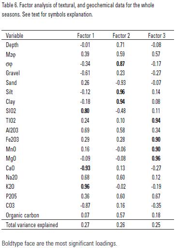
When carrying out the factor analysis for the whole of the three seasons data, three factors were retained as significant (<a href="#t6">Table 6</a>). The most important components were the concentrations of SiO2, CaO, K<sub>2</sub>O, CO<sub>3</sub> with a negative value for CaO suggesting dilution of carbonate content with the presence of terrigenous input.</font></p>     <p align="center"><font face="verdana" size="2"><a name="t6"></a></font></p>     ]]></body>
<body><![CDATA[<p align="center"><font face="verdana" size="2"><img src="/img/revistas/hbio/v18n2/a8t6.jpg"></font></p>     <p align="justify"><font face="verdana" size="2">Terrigenous sediments, i.e. clastics consisting of material eroded from the land surface included only few basic minerals (quartz, clay minerals, feldspars, muscovite and heavy minerals) (Schulz &amp; Zabel, 2000). With the exception of quartz, complete weathering of metamorphic and igneous rocks leads to the formation of clay minerals. Consequently clays represent, together with quartz, the most important minerals constituent in terrigenous sediments. The main components of clay minerals are Al and Si; Al is also present together with Na, K and Ca, in feldspars. Therefore, the concentration of these elements (Al<sub>2</sub>O<sub>3</sub>, SiO<sub>2</sub>, Na<sub>2</sub>O, K<sub>2</sub>O) in coastal sediments was taken as a measure of terrigenous supplies.</font></p>     <p align="justify"><font face="verdana" size="2">A correlation analysis of the studied parameters showed a statistically significant correlation among Al<sub>2</sub>O<sub>3</sub> and Na<sub>2</sub>O, P<sub>2</sub>O<sub>5</sub>, K<sub>2</sub>O, Fe<sub>2</sub>O<sub>3</sub> and organic carbon in the three sampling seasons suggesting that these chemical components have a terrigenous source. This was also supported by the factor analysis performed for June (2004) and February (2004) in which factor 2 grouped the preceding variables as most significant for the factor loadings (<a href="#t3">Tables 3</a> and <a href="#t5">5</a>).</font></p>     <p align="justify"><font face="verdana" size="2">The distribution pattern at the three different seasons studied of the sum of Al<sub>2</sub>O<sub>3</sub> + SiO<sub>2</sub> + Na<sub>2</sub>O + K<sub>2</sub>O + P<sub>2</sub>O<sub>5</sub> (terrigenous index) was shown in <a href="/img/revistas/hbio/v18n2/a8f3.jpg" target="_blank">Figure 3c</a>. In this study the terrigenous index was a proposal of a measure of the terrigenous influence in the sediments. The influence of terrigenous discharges was more evident during October (2004), when the entrance of sediments with a high terrigenous index was more evident along the coast line. However, terrigenous discharges travel further from the coastline seawards in February (2005).</font></p>     <p align="justify"><font face="verdana" size="2">The prevailing type of sediment in the area in the three different sampling seasons was evaluated through the ratio of the terrigenous index (Al<sub>2</sub>O<sub>3</sub> + SiO<sub>2</sub> + Na<sub>2</sub>O + +K<sub>2</sub>O + P<sub>2</sub>O<sub>5</sub>) against CaCO<sub>3</sub> that was taken as having a biogenous origin. Using the average values obtained for this ratio in each sampling trip, a differentiation was made between sites, sampling points that are above the average ratio value are constituted mainly by terrigenous sediments, samples below this value present major influence of biogenous sediments. The terrigenous influence was similar during the months of June and October (<a href="/img/revistas/hbio/v18n2/a8f3.jpg" target="_blank">Fig. 3d</a>), when carbonated sediments prevailed in the area close to the Isla de Sacrificios. Terrigenous sediments in February (2005) are at higher depths including samples 17 and 14 and carbonated sediments extended from the west of the Isla de Sacrificios landwards possibly due to the influence of the strong northerly winds that affected the reefs located to the north of the studied area.</font></p>     <p align="justify"><font face="verdana" size="2">&nbsp;</font></p>     <p align="justify"><font face="verdana" size="2"><b>ACKNOWLEDGMENTS</b></font></p>     <p align="justify"><font face="verdana" size="2">Thanks are due to the authorities of the Instituto de Ciencias del Mar y Limnologia, UNAM; to DGAPA, UNAM which supported this research through project PAPIIT IN104705&#150;2; to the Secretar&iacute;a de Marina Armada de Mexico, for their valuable support in sample collection and to Acuario of Veracruz, for their valuable help in the use of their facilities for sample processing. The authors also thank S. Santiago Perez and E. Morales de la Garza for their technical support in the collection and analysis of samples.</font></p>     <p align="justify"><font face="verdana" size="2">&nbsp;</font></p>     <p align="justify"><font face="verdana" size="2"><b>REFERENCES</b></font></p>     ]]></body>
<body><![CDATA[<!-- ref --><p align="justify"><font face="verdana" size="2">Allison, N. 1996. Geochemical anomalies in coral skeletons and their possible implications for paleoenvironmental analyses. <i>Marine Chemistry </i>55: 367&#150;379.</font>&nbsp;&nbsp;&nbsp;&nbsp;&nbsp;&nbsp;&nbsp;&nbsp;[&#160;<a href="javascript:void(0);" onclick="javascript: window.open('/scielo.php?script=sci_nlinks&ref=4072185&pid=S0188-8897200800020000800001&lng=','','width=640,height=500,resizable=yes,scrollbars=1,menubar=yes,');">Links</a>&#160;]<!-- end-ref --><!-- ref --><p align="justify"><font face="verdana" size="2">Carranza&#150;Edwards, A., L. Rosales&#150;Hoz, J. Urrutia&#150;Fucugauchi, A. Sandoval&#150;Fortanel, E. Morales&#150;de&#150;la&#150;Garza &amp; R. Lozano&#150;Santa&#150;Cruz. 2005. Geochemical distribution pattern of sediments in an active continental shelf in southern M&eacute;xico. <i>Continental Shelf Research </i>25: 521&#150;537.</font>&nbsp;&nbsp;&nbsp;&nbsp;&nbsp;&nbsp;&nbsp;&nbsp;[&#160;<a href="javascript:void(0);" onclick="javascript: window.open('/scielo.php?script=sci_nlinks&ref=4072186&pid=S0188-8897200800020000800002&lng=','','width=640,height=500,resizable=yes,scrollbars=1,menubar=yes,');">Links</a>&#160;]<!-- end-ref --><!-- ref --><p align="justify"><font face="verdana" size="2">Davies, J. C. 1986. Statistic and Data Analysis in Geology. Wiley, New York 550 p.</font>&nbsp;&nbsp;&nbsp;&nbsp;&nbsp;&nbsp;&nbsp;&nbsp;[&#160;<a href="javascript:void(0);" onclick="javascript: window.open('/scielo.php?script=sci_nlinks&ref=4072187&pid=S0188-8897200800020000800003&lng=','','width=640,height=500,resizable=yes,scrollbars=1,menubar=yes,');">Links</a>&#160;]<!-- end-ref --><!-- ref --><p align="justify"><font face="verdana" size="2">De Lazzari, A., G. Rampazzo &amp; B. Pavoni. 2004. Geochemistry of sediments in the northern and central Adriatic Sea. <i>Estuarine Coastal and Shelf Science </i>59: 429&#150;440.</font>&nbsp;&nbsp;&nbsp;&nbsp;&nbsp;&nbsp;&nbsp;&nbsp;[&#160;<a href="javascript:void(0);" onclick="javascript: window.open('/scielo.php?script=sci_nlinks&ref=4072188&pid=S0188-8897200800020000800004&lng=','','width=640,height=500,resizable=yes,scrollbars=1,menubar=yes,');">Links</a>&#160;]<!-- end-ref --><!-- ref --><p align="justify"><font face="verdana" size="2">Dunbar, G. V., G. R. Dickens &amp; R. M. Carter. 2000. Sediment flux across the Great Barrier Reef Shelf to the Queensland trough over the last 300 ky. <i>Sedimentary Geology </i>133: 49&#150;92.</font>&nbsp;&nbsp;&nbsp;&nbsp;&nbsp;&nbsp;&nbsp;&nbsp;[&#160;<a href="javascript:void(0);" onclick="javascript: window.open('/scielo.php?script=sci_nlinks&ref=4072189&pid=S0188-8897200800020000800005&lng=','','width=640,height=500,resizable=yes,scrollbars=1,menubar=yes,');">Links</a>&#160;]<!-- end-ref --><!-- ref --><p align="justify"><font face="verdana" size="2">Dunbar, G. V. &amp; G. R. Dickens. 2003. Massive siliciclastic discharge to slopes of the Great Barrier Reef Platform during sea&#150;level transgression: constrains from sediment cores between 15&ordm;S and 16&ordm;S latitude and possible explanations. <i>Sedimentary Geology </i>162: 141&#150;158.</font>&nbsp;&nbsp;&nbsp;&nbsp;&nbsp;&nbsp;&nbsp;&nbsp;[&#160;<a href="javascript:void(0);" onclick="javascript: window.open('/scielo.php?script=sci_nlinks&ref=4072190&pid=S0188-8897200800020000800006&lng=','','width=640,height=500,resizable=yes,scrollbars=1,menubar=yes,');">Links</a>&#160;]<!-- end-ref --><!-- ref --><p align="justify"><font face="verdana" size="2">Fern&aacute;ndez&#150;Eguiarte, A., A. Gallegos&#150;Garc&iacute;a &amp; J. Zavala&#150;Hidalgo. 1992 a. <i>Oceanograf&iacute;a F&iacute;sica. Masas de Agua y Mareas de los Mares Mexicanos. Atlas Nacional de M&eacute;xico (Hoja IV. 9. 2. Invierno) </i>Instituto de Geograf&iacute;a. Universidad Nacional Aut&oacute;noma de M&eacute;xico</font>&nbsp;&nbsp;&nbsp;&nbsp;&nbsp;&nbsp;&nbsp;&nbsp;[&#160;<a href="javascript:void(0);" onclick="javascript: window.open('/scielo.php?script=sci_nlinks&ref=4072191&pid=S0188-8897200800020000800007&lng=','','width=640,height=500,resizable=yes,scrollbars=1,menubar=yes,');">Links</a>&#160;]<!-- end-ref --><!-- ref --><p align="justify"><font face="verdana" size="2">Fern&aacute;ndez&#150;Eguiarte, A., A. Gallegos&#150;Garc&iacute;a &amp; J. Zavala&#150;Hidalgo. 1992 b. <i>Oceanograf&iacute;a F&iacute;sica. Masas de Agua y Mareas de los Mares Mexicanos. Atlas Nacional de M&eacute;xico (Hoja IV. 9.1. Verano) </i>Instituto de Geograf&iacute;a. Universidad Nacional Aut&oacute;noma de M&eacute;xico.</font>&nbsp;&nbsp;&nbsp;&nbsp;&nbsp;&nbsp;&nbsp;&nbsp;[&#160;<a href="javascript:void(0);" onclick="javascript: window.open('/scielo.php?script=sci_nlinks&ref=4072192&pid=S0188-8897200800020000800008&lng=','','width=640,height=500,resizable=yes,scrollbars=1,menubar=yes,');">Links</a>&#160;]<!-- end-ref --><!-- ref --><p align="justify"><font face="verdana" size="2">Folk, R. L. 1974. <i>Petrology of Sedimentary Rocks. </i>Hemphill, Austin, Texas. 159 p.</font>&nbsp;&nbsp;&nbsp;&nbsp;&nbsp;&nbsp;&nbsp;&nbsp;[&#160;<a href="javascript:void(0);" onclick="javascript: window.open('/scielo.php?script=sci_nlinks&ref=4072193&pid=S0188-8897200800020000800009&lng=','','width=640,height=500,resizable=yes,scrollbars=1,menubar=yes,');">Links</a>&#160;]<!-- end-ref --><!-- ref --><p align="justify"><font face="verdana" size="2">Gaudette, H. E., W. R. Flight, L. Toner &amp; D. W. Folger. 1974. An inexpensive titration method for the determination of organic carbon in recent sediments. <i>Journal of Sedimentary Petrology </i>44: 249&#150;253.</font>&nbsp;&nbsp;&nbsp;&nbsp;&nbsp;&nbsp;&nbsp;&nbsp;[&#160;<a href="javascript:void(0);" onclick="javascript: window.open('/scielo.php?script=sci_nlinks&ref=4072194&pid=S0188-8897200800020000800010&lng=','','width=640,height=500,resizable=yes,scrollbars=1,menubar=yes,');">Links</a>&#160;]<!-- end-ref --><!-- ref --><p align="justify"><font face="verdana" size="2">Goldsmith, S. L., M. D. Krom, A. Sandler &amp; B. Herut. 2001. Spatial trends in the chemical composition of sediments on the continental shelf and slope off the Mediterranean coast of Israel. <i>Continental Shelf Research </i>21:1879&#150;1900.</font>&nbsp;&nbsp;&nbsp;&nbsp;&nbsp;&nbsp;&nbsp;&nbsp;[&#160;<a href="javascript:void(0);" onclick="javascript: window.open('/scielo.php?script=sci_nlinks&ref=4072195&pid=S0188-8897200800020000800011&lng=','','width=640,height=500,resizable=yes,scrollbars=1,menubar=yes,');">Links</a>&#160;]<!-- end-ref --><!-- ref --><p align="justify"><font face="verdana" size="2">Hesse, P. R. 1971. <i>A Textbook of Soil Chemical Analysis</i>. John Murray, London. 520 p.</font>&nbsp;&nbsp;&nbsp;&nbsp;&nbsp;&nbsp;&nbsp;&nbsp;[&#160;<a href="javascript:void(0);" onclick="javascript: window.open('/scielo.php?script=sci_nlinks&ref=4072196&pid=S0188-8897200800020000800012&lng=','','width=640,height=500,resizable=yes,scrollbars=1,menubar=yes,');">Links</a>&#160;]<!-- end-ref --><!-- ref --><p align="justify"><font face="verdana" size="2">Linn L. J., M. L. Delaney &amp; E. R. M. Druffel. 1990. Trace metals in contemporary and seventeenth&#150;century Galapagos coral: records of seasonal and annual variations. <i>Geochemica Cosmochemica Acta </i>54: 387&#150; 394.</font>&nbsp;&nbsp;&nbsp;&nbsp;&nbsp;&nbsp;&nbsp;&nbsp;[&#160;<a href="javascript:void(0);" onclick="javascript: window.open('/scielo.php?script=sci_nlinks&ref=4072197&pid=S0188-8897200800020000800013&lng=','','width=640,height=500,resizable=yes,scrollbars=1,menubar=yes,');">Links</a>&#160;]<!-- end-ref --><!-- ref --><p align="justify"><font face="verdana" size="2">Loring, D. H. &amp; R. T. T. Rantala. 1992. Manual for the geochemical analyses of marine sediments and suspended particulate matter. <i>Earth Sciences Review </i>32: 235&#150;283.</font>&nbsp;&nbsp;&nbsp;&nbsp;&nbsp;&nbsp;&nbsp;&nbsp;[&#160;<a href="javascript:void(0);" onclick="javascript: window.open('/scielo.php?script=sci_nlinks&ref=4072198&pid=S0188-8897200800020000800014&lng=','','width=640,height=500,resizable=yes,scrollbars=1,menubar=yes,');">Links</a>&#160;]<!-- end-ref --><!-- ref --><p align="justify"><font face="verdana" size="2">Ramos, A. A., Y. Inoue &amp; S. Ohde. 2004. Metal contents in <i>Porites </i>corals: anthropogenic input of river run&#150;off into a coral reef from an urbanized area, Okinawa. <i>Marine Pollution Bulletin </i>48: 281&#150;294.</font>&nbsp;&nbsp;&nbsp;&nbsp;&nbsp;&nbsp;&nbsp;&nbsp;[&#160;<a href="javascript:void(0);" onclick="javascript: window.open('/scielo.php?script=sci_nlinks&ref=4072199&pid=S0188-8897200800020000800015&lng=','','width=640,height=500,resizable=yes,scrollbars=1,menubar=yes,');">Links</a>&#160;]<!-- end-ref --><!-- ref --><p align="justify"><font face="verdana" size="2">Rivera&#150;Ram&iacute;rez, F. 2007. <i>Determinaci&oacute;n de metales traza (Cu, Ni, Pb, V y Fe) en agua de mar y en dos especies de corales en el Arrecife Sacrificios del Sistema Arrecifal Veracruzano (SAV)</i>. Tesis de Maestr&iacute;a en Ciencias (Qu&iacute;mica Acu&aacute;tica), Posgrado en Ciencias del Mar y Limnolog&iacute;a, UNAM, M&eacute;xico. 108 p.</font>&nbsp;&nbsp;&nbsp;&nbsp;&nbsp;&nbsp;&nbsp;&nbsp;[&#160;<a href="javascript:void(0);" onclick="javascript: window.open('/scielo.php?script=sci_nlinks&ref=4072200&pid=S0188-8897200800020000800016&lng=','','width=640,height=500,resizable=yes,scrollbars=1,menubar=yes,');">Links</a>&#160;]<!-- end-ref --><!-- ref --><p align="justify"><font face="verdana" size="2">Rosales&#150;Hoz, L., A. Carranza&#150;Edwards, S. Santiago&#150;P&eacute;rez &amp; E. Morales&#150;de&#150;la&#150;Garza. 2005. Spatial trends in the geochemical composition of sediments in the Panuco River discharge area, Gulf of M&eacute;xico. <i>Environmental Geology </i>48: 496&#150;506.</font>&nbsp;&nbsp;&nbsp;&nbsp;&nbsp;&nbsp;&nbsp;&nbsp;[&#160;<a href="javascript:void(0);" onclick="javascript: window.open('/scielo.php?script=sci_nlinks&ref=4072201&pid=S0188-8897200800020000800017&lng=','','width=640,height=500,resizable=yes,scrollbars=1,menubar=yes,');">Links</a>&#160;]<!-- end-ref --><!-- ref --><p align="justify"><font face="verdana" size="2">Schulz, H.D. &amp; M. Zabel. 2000. <i>Marine Geochemistry</i>. Springer Verlag, Berlin. 455 p.</font>&nbsp;&nbsp;&nbsp;&nbsp;&nbsp;&nbsp;&nbsp;&nbsp;[&#160;<a href="javascript:void(0);" onclick="javascript: window.open('/scielo.php?script=sci_nlinks&ref=4072202&pid=S0188-8897200800020000800018&lng=','','width=640,height=500,resizable=yes,scrollbars=1,menubar=yes,');">Links</a>&#160;]<!-- end-ref --><!-- ref --><p align="justify"><font face="verdana" size="2">Shen, G. T. &amp; E. A. Boyle. 1988. Determination of lead, cadmium and other trace metals in annually&#150;banded corals. <i>Chemical Geology </i>67: 47&#150;62.</font>&nbsp;&nbsp;&nbsp;&nbsp;&nbsp;&nbsp;&nbsp;&nbsp;[&#160;<a href="javascript:void(0);" onclick="javascript: window.open('/scielo.php?script=sci_nlinks&ref=4072203&pid=S0188-8897200800020000800019&lng=','','width=640,height=500,resizable=yes,scrollbars=1,menubar=yes,');">Links</a>&#160;]<!-- end-ref --><!-- ref --><p align="justify"><font face="verdana" size="2">Tamayo, J. L. 1991. <i>Geograf&iacute;a Moderna de M&eacute;xico. </i>Ed. Trillas, M&eacute;xico. 400 p.</font>&nbsp;&nbsp;&nbsp;&nbsp;&nbsp;&nbsp;&nbsp;&nbsp;[&#160;<a href="javascript:void(0);" onclick="javascript: window.open('/scielo.php?script=sci_nlinks&ref=4072204&pid=S0188-8897200800020000800020&lng=','','width=640,height=500,resizable=yes,scrollbars=1,menubar=yes,');">Links</a>&#160;]<!-- end-ref --><!-- ref --><p align="justify"><font face="verdana" size="2">Schumm, S. A. 1977. <i>The Fluvial System. </i>Wiley &amp; Sons, New York. 338 p.</font>&nbsp;&nbsp;&nbsp;&nbsp;&nbsp;&nbsp;&nbsp;&nbsp;[&#160;<a href="javascript:void(0);" onclick="javascript: window.open('/scielo.php?script=sci_nlinks&ref=4072205&pid=S0188-8897200800020000800021&lng=','','width=640,height=500,resizable=yes,scrollbars=1,menubar=yes,');">Links</a>&#160;]<!-- end-ref --><!-- ref --><p align="justify"><font face="verdana" size="2">Voudouris, K. S., N. J. Lambrakis, G. Papatheothorou &amp; P. Daskalaki 1997. An application of factor analysis for the study of the hydro&#150;geological conditions in Plio&#150;Pleistocene aquifers of NW Achaia (NW Peloponnesus Grece). <i>Mathematical Geology </i>29: 43&#150;59.</font>&nbsp;&nbsp;&nbsp;&nbsp;&nbsp;&nbsp;&nbsp;&nbsp;[&#160;<a href="javascript:void(0);" onclick="javascript: window.open('/scielo.php?script=sci_nlinks&ref=4072206&pid=S0188-8897200800020000800022&lng=','','width=640,height=500,resizable=yes,scrollbars=1,menubar=yes,');">Links</a>&#160;]<!-- end-ref --> ]]></body><back>
<ref-list>
<ref id="B1">
<nlm-citation citation-type="journal">
<person-group person-group-type="author">
<name>
<surname><![CDATA[Allison]]></surname>
<given-names><![CDATA[N.]]></given-names>
</name>
</person-group>
<article-title xml:lang="en"><![CDATA[Geochemical anomalies in coral skeletons and their possible implications for paleoenvironmental analyses]]></article-title>
<source><![CDATA[Marine Chemistry]]></source>
<year>1996</year>
<volume>55</volume>
<page-range>367-379</page-range></nlm-citation>
</ref>
<ref id="B2">
<nlm-citation citation-type="journal">
<person-group person-group-type="author">
<name>
<surname><![CDATA[Carranza-Edwards]]></surname>
<given-names><![CDATA[A.]]></given-names>
</name>
<name>
<surname><![CDATA[Rosales-Hoz]]></surname>
<given-names><![CDATA[L.]]></given-names>
</name>
<name>
<surname><![CDATA[Urrutia-Fucugauchi]]></surname>
<given-names><![CDATA[J.]]></given-names>
</name>
<name>
<surname><![CDATA[Sandoval-Fortanel]]></surname>
<given-names><![CDATA[A.]]></given-names>
</name>
<name>
<surname><![CDATA[Morales-de-la-Garza]]></surname>
<given-names><![CDATA[E.]]></given-names>
</name>
<name>
<surname><![CDATA[Lozano-Santa-Cruz]]></surname>
<given-names><![CDATA[R.]]></given-names>
</name>
</person-group>
<article-title xml:lang="en"><![CDATA[Geochemical distribution pattern of sediments in an active continental shelf in southern México]]></article-title>
<source><![CDATA[Continental Shelf Research]]></source>
<year>2005</year>
<volume>25</volume>
<page-range>521-537</page-range></nlm-citation>
</ref>
<ref id="B3">
<nlm-citation citation-type="book">
<person-group person-group-type="author">
<name>
<surname><![CDATA[Davies]]></surname>
<given-names><![CDATA[J. C.]]></given-names>
</name>
</person-group>
<source><![CDATA[Statistic and Data Analysis in Geology]]></source>
<year>1986</year>
<page-range>550</page-range><publisher-loc><![CDATA[New York ]]></publisher-loc>
<publisher-name><![CDATA[Wiley]]></publisher-name>
</nlm-citation>
</ref>
<ref id="B4">
<nlm-citation citation-type="journal">
<person-group person-group-type="author">
<name>
<surname><![CDATA[De Lazzari]]></surname>
<given-names><![CDATA[A.]]></given-names>
</name>
<name>
<surname><![CDATA[Rampazzo]]></surname>
<given-names><![CDATA[G.]]></given-names>
</name>
<name>
<surname><![CDATA[Pavoni]]></surname>
<given-names><![CDATA[B.]]></given-names>
</name>
</person-group>
<article-title xml:lang="en"><![CDATA[Geochemistry of sediments in the northern and central Adriatic Sea]]></article-title>
<source><![CDATA[Estuarine Coastal and Shelf Science]]></source>
<year>2004</year>
<volume>59</volume>
<page-range>429-440</page-range></nlm-citation>
</ref>
<ref id="B5">
<nlm-citation citation-type="journal">
<person-group person-group-type="author">
<name>
<surname><![CDATA[Dunbar]]></surname>
<given-names><![CDATA[G. V.]]></given-names>
</name>
<name>
<surname><![CDATA[Dickens]]></surname>
<given-names><![CDATA[G. R.]]></given-names>
</name>
<name>
<surname><![CDATA[Carter]]></surname>
<given-names><![CDATA[R. M.]]></given-names>
</name>
</person-group>
<article-title xml:lang="en"><![CDATA[Sediment flux across the Great Barrier Reef Shelf to the Queensland trough over the last 300 ky]]></article-title>
<source><![CDATA[Sedimentary Geology]]></source>
<year>2000</year>
<volume>133</volume>
<page-range>49-92</page-range></nlm-citation>
</ref>
<ref id="B6">
<nlm-citation citation-type="journal">
<person-group person-group-type="author">
<name>
<surname><![CDATA[Dunbar]]></surname>
<given-names><![CDATA[G. V.]]></given-names>
</name>
<name>
<surname><![CDATA[Dickens]]></surname>
<given-names><![CDATA[G. R.]]></given-names>
</name>
</person-group>
<article-title xml:lang="en"><![CDATA[Massive siliciclastic discharge to slopes of the Great Barrier Reef Platform during sea-level transgression: constrains from sediment cores between 15ºS and 16ºS latitude and possible explanations]]></article-title>
<source><![CDATA[Sedimentary Geology]]></source>
<year>2003</year>
<volume>162</volume>
<page-range>141-158</page-range></nlm-citation>
</ref>
<ref id="B7">
<nlm-citation citation-type="book">
<person-group person-group-type="author">
<name>
<surname><![CDATA[Fernández-Eguiarte]]></surname>
<given-names><![CDATA[A.]]></given-names>
</name>
<name>
<surname><![CDATA[Gallegos-García]]></surname>
<given-names><![CDATA[A.]]></given-names>
</name>
<name>
<surname><![CDATA[Zavala-Hidalgo]]></surname>
<given-names><![CDATA[J.]]></given-names>
</name>
</person-group>
<source><![CDATA[Oceanografía Física. Masas de Agua y Mareas de los Mares Mexicanos: Atlas Nacional de México (Hoja IV. 9. 2. Invierno)]]></source>
<year>1992</year>
<publisher-name><![CDATA[Instituto de Geografía. Universidad Nacional Autónoma de México]]></publisher-name>
</nlm-citation>
</ref>
<ref id="B8">
<nlm-citation citation-type="book">
<person-group person-group-type="author">
<name>
<surname><![CDATA[Fernández-Eguiarte]]></surname>
<given-names><![CDATA[A.]]></given-names>
</name>
<name>
<surname><![CDATA[Gallegos-García]]></surname>
<given-names><![CDATA[A.]]></given-names>
</name>
<name>
<surname><![CDATA[Zavala-Hidalgo]]></surname>
<given-names><![CDATA[J.]]></given-names>
</name>
</person-group>
<source><![CDATA[Oceanografía Física. Masas de Agua y Mareas de los Mares Mexicanos. Atlas Nacional de México (Hoja IV. 9.1. Verano)]]></source>
<year>1992</year>
<publisher-name><![CDATA[Instituto de Geografía. Universidad Nacional Autónoma de México]]></publisher-name>
</nlm-citation>
</ref>
<ref id="B9">
<nlm-citation citation-type="book">
<person-group person-group-type="author">
<name>
<surname><![CDATA[Folk]]></surname>
<given-names><![CDATA[R. L.]]></given-names>
</name>
</person-group>
<source><![CDATA[Petrology of Sedimentary Rocks]]></source>
<year>1974</year>
<page-range>159</page-range><publisher-loc><![CDATA[Austin^eTexas Texas]]></publisher-loc>
<publisher-name><![CDATA[Hemphill]]></publisher-name>
</nlm-citation>
</ref>
<ref id="B10">
<nlm-citation citation-type="journal">
<person-group person-group-type="author">
<name>
<surname><![CDATA[Gaudette]]></surname>
<given-names><![CDATA[H. E.]]></given-names>
</name>
<name>
<surname><![CDATA[Flight]]></surname>
<given-names><![CDATA[W. R.]]></given-names>
</name>
<name>
<surname><![CDATA[Toner]]></surname>
<given-names><![CDATA[L.]]></given-names>
</name>
<name>
<surname><![CDATA[Folger]]></surname>
<given-names><![CDATA[D. W.]]></given-names>
</name>
</person-group>
<article-title xml:lang="en"><![CDATA[An inexpensive titration method for the determination of organic carbon in recent sediments]]></article-title>
<source><![CDATA[Journal of Sedimentary Petrology]]></source>
<year>1974</year>
<volume>44</volume>
<page-range>249-253</page-range></nlm-citation>
</ref>
<ref id="B11">
<nlm-citation citation-type="journal">
<person-group person-group-type="author">
<name>
<surname><![CDATA[Goldsmith]]></surname>
<given-names><![CDATA[S. L.]]></given-names>
</name>
<name>
<surname><![CDATA[Krom]]></surname>
<given-names><![CDATA[M. D.]]></given-names>
</name>
<name>
<surname><![CDATA[Sandler]]></surname>
<given-names><![CDATA[A.]]></given-names>
</name>
<name>
<surname><![CDATA[Herut]]></surname>
<given-names><![CDATA[B.]]></given-names>
</name>
</person-group>
<article-title xml:lang="en"><![CDATA[Spatial trends in the chemical composition of sediments on the continental shelf and slope off the Mediterranean coast of Israel]]></article-title>
<source><![CDATA[Continental Shelf Research]]></source>
<year>2001</year>
<volume>21</volume>
<page-range>1879-1900</page-range></nlm-citation>
</ref>
<ref id="B12">
<nlm-citation citation-type="book">
<person-group person-group-type="author">
<name>
<surname><![CDATA[Hesse]]></surname>
<given-names><![CDATA[P. R.]]></given-names>
</name>
</person-group>
<source><![CDATA[A Textbook of Soil Chemical Analysis]]></source>
<year>1971</year>
<page-range>520</page-range><publisher-loc><![CDATA[London ]]></publisher-loc>
<publisher-name><![CDATA[John Murray]]></publisher-name>
</nlm-citation>
</ref>
<ref id="B13">
<nlm-citation citation-type="journal">
<person-group person-group-type="author">
<name>
<surname><![CDATA[Linn]]></surname>
<given-names><![CDATA[L. J.]]></given-names>
</name>
<name>
<surname><![CDATA[Delaney]]></surname>
<given-names><![CDATA[M. L.]]></given-names>
</name>
<name>
<surname><![CDATA[Druffel]]></surname>
<given-names><![CDATA[E. R. M.]]></given-names>
</name>
</person-group>
<article-title xml:lang="en"><![CDATA[Trace metals in contemporary and seventeenth-century Galapagos coral: records of seasonal and annual variations]]></article-title>
<source><![CDATA[Geochemica Cosmochemica Acta]]></source>
<year>1990</year>
<volume>54</volume>
<page-range>387- 394</page-range></nlm-citation>
</ref>
<ref id="B14">
<nlm-citation citation-type="journal">
<person-group person-group-type="author">
<name>
<surname><![CDATA[Loring]]></surname>
<given-names><![CDATA[D. H.]]></given-names>
</name>
<name>
<surname><![CDATA[Rantala]]></surname>
<given-names><![CDATA[R. T. T.]]></given-names>
</name>
</person-group>
<article-title xml:lang="en"><![CDATA[Manual for the geochemical analyses of marine sediments and suspended particulate matter]]></article-title>
<source><![CDATA[Earth Sciences Review]]></source>
<year>1992</year>
<volume>32</volume>
<page-range>235-283</page-range></nlm-citation>
</ref>
<ref id="B15">
<nlm-citation citation-type="journal">
<person-group person-group-type="author">
<name>
<surname><![CDATA[Ramos]]></surname>
<given-names><![CDATA[A. A.]]></given-names>
</name>
<name>
<surname><![CDATA[Inoue]]></surname>
<given-names><![CDATA[Y.]]></given-names>
</name>
<name>
<surname><![CDATA[Ohde]]></surname>
<given-names><![CDATA[S.]]></given-names>
</name>
</person-group>
<article-title xml:lang="en"><![CDATA[Metal contents in Porites corals: anthropogenic input of river run-off into a coral reef from an urbanized area, Okinawa]]></article-title>
<source><![CDATA[Marine Pollution Bulletin]]></source>
<year>2004</year>
<volume>48</volume>
<page-range>281-294</page-range></nlm-citation>
</ref>
<ref id="B16">
<nlm-citation citation-type="">
<person-group person-group-type="author">
<name>
<surname><![CDATA[Rivera-Ramírez]]></surname>
<given-names><![CDATA[F.]]></given-names>
</name>
</person-group>
<source><![CDATA[Determinación de metales traza (Cu, Ni, Pb, V y Fe) en agua de mar y en dos especies de corales en el Arrecife Sacrificios del Sistema Arrecifal Veracruzano (SAV)]]></source>
<year>2007</year>
<page-range>108</page-range></nlm-citation>
</ref>
<ref id="B17">
<nlm-citation citation-type="journal">
<person-group person-group-type="author">
<name>
<surname><![CDATA[Rosales-Hoz]]></surname>
<given-names><![CDATA[L.]]></given-names>
</name>
<name>
<surname><![CDATA[Carranza-Edwards]]></surname>
<given-names><![CDATA[A.]]></given-names>
</name>
<name>
<surname><![CDATA[Santiago-Pérez]]></surname>
<given-names><![CDATA[S.]]></given-names>
</name>
<name>
<surname><![CDATA[Morales-de-la-Garza]]></surname>
<given-names><![CDATA[E.]]></given-names>
</name>
</person-group>
<article-title xml:lang="en"><![CDATA[Spatial trends in the geochemical composition of sediments in the Panuco River discharge area, Gulf of México]]></article-title>
<source><![CDATA[Environmental Geology]]></source>
<year>2005</year>
<volume>48</volume>
<page-range>496-506</page-range></nlm-citation>
</ref>
<ref id="B18">
<nlm-citation citation-type="book">
<person-group person-group-type="author">
<name>
<surname><![CDATA[Schulz]]></surname>
<given-names><![CDATA[H.D.]]></given-names>
</name>
<name>
<surname><![CDATA[Zabel]]></surname>
<given-names><![CDATA[M.]]></given-names>
</name>
</person-group>
<source><![CDATA[Marine Geochemistry]]></source>
<year>2000</year>
<page-range>455</page-range><publisher-loc><![CDATA[Berlin ]]></publisher-loc>
<publisher-name><![CDATA[Springer Verlag]]></publisher-name>
</nlm-citation>
</ref>
<ref id="B19">
<nlm-citation citation-type="journal">
<person-group person-group-type="author">
<name>
<surname><![CDATA[Shen]]></surname>
<given-names><![CDATA[G. T.]]></given-names>
</name>
<name>
<surname><![CDATA[Boyle]]></surname>
<given-names><![CDATA[E. A.]]></given-names>
</name>
</person-group>
<article-title xml:lang="en"><![CDATA[Determination of lead, cadmium and other trace metals in annually-banded corals]]></article-title>
<source><![CDATA[Chemical Geology]]></source>
<year>1988</year>
<volume>67</volume>
<page-range>47-62</page-range></nlm-citation>
</ref>
<ref id="B20">
<nlm-citation citation-type="book">
<person-group person-group-type="author">
<name>
<surname><![CDATA[Tamayo]]></surname>
<given-names><![CDATA[J. L.]]></given-names>
</name>
</person-group>
<source><![CDATA[Geografía Moderna de México]]></source>
<year>1991</year>
<page-range>400</page-range><publisher-name><![CDATA[Trillas]]></publisher-name>
</nlm-citation>
</ref>
<ref id="B21">
<nlm-citation citation-type="book">
<person-group person-group-type="author">
<name>
<surname><![CDATA[Schumm]]></surname>
<given-names><![CDATA[S. A.]]></given-names>
</name>
</person-group>
<source><![CDATA[The Fluvial System]]></source>
<year>1977</year>
<page-range>338</page-range><publisher-loc><![CDATA[New York ]]></publisher-loc>
<publisher-name><![CDATA[Wiley & Sons]]></publisher-name>
</nlm-citation>
</ref>
<ref id="B22">
<nlm-citation citation-type="journal">
<person-group person-group-type="author">
<name>
<surname><![CDATA[Voudouris]]></surname>
<given-names><![CDATA[K. S.]]></given-names>
</name>
<name>
<surname><![CDATA[Lambrakis]]></surname>
<given-names><![CDATA[N. J.]]></given-names>
</name>
<name>
<surname><![CDATA[Papatheothorou]]></surname>
<given-names><![CDATA[G.]]></given-names>
</name>
<name>
<surname><![CDATA[Daskalaki]]></surname>
<given-names><![CDATA[P.]]></given-names>
</name>
</person-group>
<article-title xml:lang="en"><![CDATA[An application of factor analysis for the study of the hydro-geological conditions in Plio-Pleistocene aquifers of NW Achaia (NW Peloponnesus Grece)]]></article-title>
<source><![CDATA[Mathematical Geology]]></source>
<year>1997</year>
<volume>29</volume>
<page-range>43-59</page-range></nlm-citation>
</ref>
</ref-list>
</back>
</article>
