


 nueva página del texto (beta)
 Inglés (pdf)
 Artículo en XML
 Referencias del artículo
 Enviar artículo por email
 Citado por SciELO
  Similares en
SciELO
Similares en
SciELO 
 Permalink
1. Introduction
The motivation for this work is associated with the need to estimate the academic production capacities of the Latin American region in the GISc area. The issue was addressed by López-Vázquez and Bernabé-Poveda (2020) who, based upon various expert classifications, identified works by authors from the region published in those journals that frequently accept GISc works. Few of these journals can be classified as exclusive to GISc, so a mixture of topics in published works can be expected in them. Therefore, the authors admit that the results obtained would be biased, which justifies the need for a classification at the article level, and not at the journal level. After the question regarding how many GISc articles have authors from the Latin American region? or how many academics in GISc does the region have? the need for rules to identify them immediately arises. And the beginning of everything would be to define what GISc is.
GISc has been recognized as difficult to define or delimit (Couclelis, 2012; Blaschke & Merschdorf, 2014). The mere use of Geographic Information (GI hereinafter) within a paper is not useful, since all the works of any of the geosciences would qualify as GISc. Some initial efforts defined it as the science behind Geographic Information Systems (GIS) (Goodchild, 2009) which opens the door to include in the GISc category any article that uses GIS. Concerned about the risk that lax or expansive definitions may conclude that GISc encompasses several consolidated sciences, Reitsma (2013) introduces the very suitable term “scientific gerrymandering” to illustrate the situation of GISc in relation to other geosciences. The word gerrymandering alludes to the process of arbitrarily moving the boundaries of electoral districts in order to favor or harm certain candidates. There is a clear parallel in a science management context. For purposes of academic administration, resource allocation, competition for students, etc. for researchers in any area it is important to have a recognized field of action within science as a whole (Blaschke et al., 2014). In some cases, the limit is clear: all living organisms are studied by Biology, and all celestial objects by Astronomy. In other cases, the boundaries are not so sharp. The traditional sciences have built their own sphere over time, an advantage that emerging sciences do not have, especially when they have a significant overlap with the preexisting ones. And GISc is one of these cases.
According to Mark (2000), from its inception GISc reexamined fundamental issues in geography, cartography and geodesy, incorporated developments in cognitive and information sciences and sometimes stepped on the same space as statistics, mathematics, psychology or computer science. The objective of this work is to suggest a way to delimit a scope for GISc with enough interest but without including significant portions of other already established sciences (and in particular, other geosciences).
The rest of the article is organized in the following way. After this Introduction, a background of the GISc and Geomatics definitions will be presented. Next, the DIKW paradigm will be described. It will be key in our proposal because it distinguishes between Data and Information concepts. Some formal aspects that we consider are already present in GISc will be discussed, and the proposed placement of GISc among the formal sciences will be presented.
The proposed GISc definition will be offered, followed by a Discussion. Finally, the Conclusions, Acknowledgments and References will be presented.
2. GISc definitions
At the beginning of the 90s the name of GISc had already been handled informally. It was first presented in a keynote speech (Goodchild, 1990) paradoxically using a different title (Spatial Information Science). After some adjustments, that presentation was published in Goodchild (1992) in what is considered the official birth of the denomination (Blaschke et al., 2014). In this work, the author did not present a formal definition, but rather grouped the activities that he considered to be of interest to GISc into eight blocks: Data collection and measurement; Data capture; Spatial statistics; Data modeling and theories of spatial data; Data structures, algorithms and processes; Display; Analytical tools; and Institutional, managerial, and ethical issues. Notice the repeated presence of the word Data, and the lack of mention of Information. In his proposal Goodchild admitted that the list was incomplete. Due to the context of the time, the connections to GIS weighed heavily on the text. The term “Geographic Information System” has its roots in the Canadian Geographic Information System of the 1960s (Tomlinson, 1984). This term and this technology were already well established in the 90s with a high degree of acceptance by the scientific community. For this reason, it is very justifiable that the science that was wanted to characterize remained close to this denomination. Confirming this relationship, Mark (2000) maintains:
Geographic Information Science (GIScience) is the basic research field that seeks to redefine geographic concepts and their use in the context of GIS. GIScience also examines the impacts of GIS on individuals and society, and the influences of society on GIS. GIScience reexamines some of the most fundamental themes in traditional spatially oriented fields such as geography, cartography, and geodesy, while incorporating more recent developments in cognitive and information science. It also overlaps with and draws from more specialized research fields such as computer science, statistics, mathematics, and psychology, and contributes to progress in those fields.
Notice the close relationship with GIS, the recognition of overlaps with other already established sciences, and the expansiveness of the delimitation. We emphasize that the first three bullets clearly refer to Data, not Information. As in the case of Goodchild [8] this does not really constitute the definition of a science. As a way out of the problem Mark (2003) proposes to consider GISc as a specialization of Information Science. Based on a definition attributed to Shuman (1992) and adding the word “geographic” before “information”, he proposed:
GISc is very difficult to define…the field of GISc, however, may be defined as one that investigates the properties and behavior of geographic information, how it is transferred from one mind to another, and optimal means for making that transfer, in both natural and artificial systems. Finally, GISc is concerned with the effects of information on people and on machines.
This proposal was not echoed in the literature. In the same work, Mark (2003) proposes a new list of areas of interest, comparing his proposal against those of Goodchild (1992) and those alluded to in the application to the NSF. Later on, this list will be compared against the proposed definition that will be presented in this work.
Difficulties finding a consensus definition persisted. In this sense, Goodchild (2009) recognizes it again and chooses to affirm that “... GISc is the science behind GIS ...”, calling GISc the scientific knowledge on which GIS is based. He states that GISc can also be defined as the set of fundamental questions raised by technology or critical problems that arise when technology is employed. These would include precision and uncertainty, scale, and methods used to capture the infinite complexity of the real world in binary digits. This close relationship with the software system that is at the origin of the denomination will be analyzed again later.
For our purposes (identifying which articles are and which are not about GISc) it is necessary that the definition offers easy-to-interpret criteria. This characteristic is shown, for example, in the definition offered by ISO for the closely related field of Geomatics: "Geomatics: (ref: ISO/TC211/WG1 N119)1 “Geomatics is defined in the ISO/TC 211 series of standards as the discipline concerned with the collection, distribution, storage, analysis, processing, presentation of geographic data or geographic information”.
Notice here that “geographic data” is synonymous with or equivalent to “geographic information”. For our purposes it will be seen that it is important to make a distinction between them, so their differences will be analyzed below using the DIKW paradigm as a reference.
3. The DIKW paradigm
The problem addressed in this work is to establish a boundary for GISc, either natural or just convenient, to avoid scientific gerrymandering to other sciences. To do this, the DIKW (Data-Information-Knowledge-Wisdom) paradigm is used.
Elaborating ideas taken from Ackoff (1989), Rowley (2007) affirms that data leads to information that in turn leads to knowledge and this leads to wisdom, thus accepting that the four concepts (data, information, knowledge and wisdom) are different and for this reason a science that claims to study data must have differences from a science that claims to focus on information.
Etymologically GISc is the science that deals with geographic information (GI), which is its object of study par excellence. There are authors who in the same field of action speak of "spatial data" (Spatial Data Science, Spatial Data Infrastructures, etc.) instead of GI, emphasizing the word data and omitting the adjective “geographic” in favor of “spatial” which would be something more general. But the important thing here is in the existing nuance between data and information.
Following Scheider et al., (2020), in our proposal real world information will be considered by empirical sciences (such as Demography, Biology, Geology, etc.) defined as opposed to formal sciences (such as Mathematics, Computer Science, Logic or Linguistics) that do not require experimental validation. Couclelis (2016) argues the same, trying to separate Information Sciences from empirical sciences. For our case in particular, it can be said that the data that GISc manages and presents are intended to finally serve empirical sciences. Such sciences will build information from the data in order to generate their specific knowledge, a process that in our proposal would not be convenient to consider within GISc.
As proposed by Reitsma (2013), GISc shares with other formal sciences the fact of not studying the real physical world, which is studied inductively and abductively by other sciences such as Edaphology, Climatology, Hydrology, etc. These sciences often model the physical world in great detail, but each from a different point of view. In our proposal, GISc studies the internal properties of geographic data which can be used later by any of the geosciences. Couclelis (2016) said: “…we are not doing Hydrology, Forestry or Urban Studies but trying to help answer questions posed by hydrologists, foresters, planners, and any others, in the most appropriate and helpful ways.”
Therefore, the investigations and discoveries of GISc can be applied by all the sciences that use geographic data. To clarify the above statement that GISc does not have to do with the real world but only with the internal properties of the data, we can put some well-known examples such as the arithmetic mean, which is a non existing concept in the real world but which is applied by all the sciences that use quantities. We are also talking about imaginary numbers that do not exist in the real world but are essential to describe both electromagnetism and relativity and to explain the behavior of quantum matter. In our proposal, GISc would address everything that can be done or obtained from generic geographic data. Its results take the form of algorithms, rules for viewing, organization techniques, indexing schemes, internal structures, and other theoretical and technological solutions. The assertion that GISc would not deal with the real world but with data that represents some part of its reality leads us to imagine GISc as a formal science like those already mentioned. As such, it has its own areas of research and would fulfill the role of supporting other empirical sciences that operate based on spatial data. It is proposed that once the data have been processed by GISc, it is admitted that the GI will be produced later by the corresponding empirical science, certainly with the assistance of GISc but only as support in the basic science part of the process. With this approach you could establish a convenient frontier for GISc, and the problem of scientific gerrymandering would be solved. By proposing to separate GISc from Information, it moves it away from empirical sciences and brings it closer to formal sciences, which is an unexpected consequence that should be analyzed.
4. The Character of Formal Science
Reitsma (2013) has already considered the question whether or not GISc is a science. Here we will go a step further, and see if it can be described as a formal science. Høyrup (2003) acutely points out “...In any proper sense, a ‘formal science’ is a science which does not positively tell us anything about the world....”. Any science that ignores the Information and limits itself to the Data would meet this characteristic. Without contradicting it, Franklin (1994) argues that formal sciences could potentially generate knowledge that is demonstrable (in a mathematical sense) but still applicable to the real world. When asked about what is a formal science? Löwe (2002) proposes to consider two possible responses that are not equivalent. One of them characterizes the formal sciences by using the deductive analysis of formal systems, which are independent of human influence. The second says that formal sciences are aimed at understanding systems without an empirical component. Not having an empirical component implies that the validity of its conclusions does not result from or are supported by experimental data but simply supported by reasoning. The author put Mathematics, Theoretical Philosophy, Informatics and Formal Linguistics as examples, while we might add Statistics and Logic, without thereby closing the list.
4.1. Formal characteristics found in GISc
The approach we propose to test here is not to demonstrate that GISc is a formal science, but to show that it shares many characteristics with other already recognized sciences as such. With this we aspire to establish a conjecture, which future works could demonstrate. To support our point of view, essential characteristics of formal sciences that can be identified in GISc will be illustrated, prioritizing references published in journals from the GISc area. They include the following:
GISc has formal languages, which cover parts of its field of activity. As examples, we can cite Kuhn and Ballatore (2015) with a proposal partially implemented in Python; Loose Programming (Kruiger et al., 2020); Map Algebra with its variants (Cordeiro et al., 2009); Map Calculus (Haklay, 2004); various Query languages like Geo-SAL (Svensson & Huang, 1991), MADS (Parent et al., 2006), GeoPQL (D’Ulizia, 2012) and the one due to Wang et al. (2019), among others.
GISc has symbol alphabets, which are manipulated by the different algebras. For example, in a GIS the alphabet is made up of all the acceptable names for a coverage. But in addition to this basic example there are other more refined ones. For example, the FlexTrack system (Moussalli et al., 2015) uses an alphabet to define regions of interest (schools, airports, neighborhoods...) within a coverage in order to support queries based on spatio-temporal location.
GISc has formal Grammars or Syntax, offering rules for joining symbols. As an example, the languages of GIS can be cited, or at some more abstract level of formalization of spatial relationships and connectivity (Liu et al., 2018), modeling of natural bodies (Rongier et al., 2017), identification of shapes (Li et al., 2019), consistency verification in 3D models (Nikoohemat et al., 2021), and the classics on image syntax (Dondis, 1973), among others.
GISc has several sets of Axioms, such as those that appear in the context of Ontologies (Torres et al., 2011) but also in the language formulation itself (Kuhn & Ballatore, 2015). There is a sustained effort to elaborate geo-ontologies to describe geographic entities and their relationships (Agarwal, 2005), to make viable a theory of spatial representation (Tambassi, 2017), to support the formulation of consistency restrictions in geographic databases (Frank, 2001), among others.
GISc has a set of transformation or inference rules that allow conclusions to be drawn. For example, Wang et al. (2019) establishes topological relationships between regions and their intersections.
With the above, it has been illustrated that the conjecture that GISc is a formal science is well founded, although it is not our intention to demonstrate it.
4.2. GISc connection with other formal sciences
The examples that emerge in the previous items frequently connect GISc with Informatics, but there are also strong connections with other sciences previously accepted as formal. For example, the entire field of Spatial Statistics can be correctly interpreted as a branch of Statistics, but it can also be pointed out that the motivation and many of the advances made there are justified, described and published in geoscience journals such as Mathematical Geology. The relationship with Mathematics is also close. Everything related to remote sensor image processing (or other data in raster format such as DEM) has a significant overlap with Signal Processing. The Interpolation problem is relatively lateral in Mathematics itself but it is central and very popular in GISc (Fisher, 2007; Lees, 2016).
To further highlight the difference between data and information, you can imagine the following situation. Suppose that arsenic contamination is being studied in a region, and point data is supplied. They are first incorporated into a GIS, and afterwards some standardized process are applied. Anomalou data controls are carried out, interpolated algorithms selected and finally maps are generated with the spatial distribution of the pollutant. After finishing the study, the units were found to be wrong: they were assumed to be μg/L and actually they were mg/L (a factor of 1000). The information produced changes drastically, since what were originally acceptable levels became acute contamination. However, all processing described above with the data was immune to this change, except for the legend on the maps produced.
Regardless of the field to which the data belong, to present them visually there are invariants (Gibson, 1950) and perceptual properties (Bertin, 1973) to be considered that do not depend on what information are involved. These general rules say, among others, that large is more important than small, dark more than light, qualitative variation is associated with tone, ordered variation with lightness and quantitative with size. Bertin's graphic semiology (1973), the perceptual properties of visual variables, visual constancies and contrasts (Monasse & Guichard, 2000), the principles of Gelstalt (Wertheimer, 1938), with which to show results on maps (Wallace et al., 1998) show us universal expressive characteristics regardless of whether what the data represents are real objects or mental concepts. The same occurs with its application to a visual language based on patterns (morphological elements as words, shapes and images; syntax based on basic morphemes; semantics dealing with the meaning of composite visual language elements and pragmatics dealing with different communication problems in different contexts) (Flieder & Mödritscher, 2006). There is therefore a formal component outside the real (in the information sense) that we use in the GISc to show results.
To construct the representations of Figure 1 it is not necessary to have the information itself, but it is enough to know the numerical values of the data plus just some characteristics or properties (like continuity).
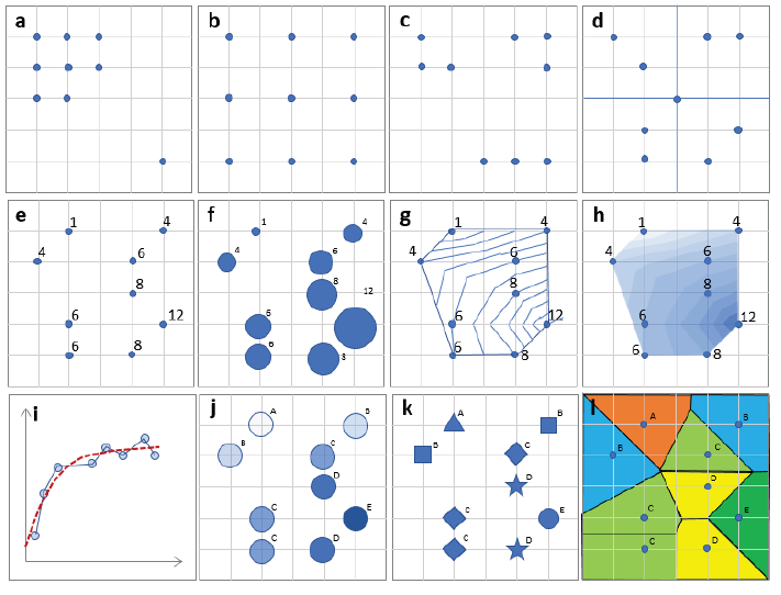
Figure 1 Internal information of the data without knowing its field of application: (a-d) spatial location provides us with information regardless of what they represent. (e-h) shows the same numerical values (continuous or discrete) with different representations. The set is susceptible to a geostatistical treatment (i), represented by different color tones (j) on a Likert scale, or simply different symbols (k). Also the field could be represented with a Voronoi diagram (l). Neither to carry out the different representations nor to elaborate a geostatistical study is it necessary to know what magnitude is being represented. Own elaboration.
5. GISc: what's behind GIS
It can be admitted that practically all the operations and processing that is done in GISc do not require an intimate knowledge or interpretation of the data itself, but that the tools and methods included are general enough to be applicable to a variety of cases just knowing that they are spatial data (Anselin, 2020).
Another argument that supports the suggestion that GISc is a non-experimental science and that its processing is within the data domain is the following. It has been claimed (Goodchild, 2009) that GISc is the science behind a GIS. A GIS is a software system capable of manipulating geographic data. But the system exists even if there is no data, and in fact it is sold without it. As a system, it includes algorithms, procedures, knowledge, etc. which are prior to the system being loaded with data, and of course, to producing information. Therefore, it is easy to argue that all the science behind that system is also preexisting to the data that will later feed it. This makes software and the science behind it independent of the domain of application, a characteristic that Laplante (1990) points out that formal science possesses and that Reitsma (Reitsma, 2013) also admits.
6. Location of the GISc in the pyramid of knowledge
Returning to the DIKW paradigm, it is important to locate the different phases and relative location of the science that is being mentioned. Figure 2 illustrates three levels of the scheme. The raw data sources are located in the base, illustrated with the name of various organizations that capture data of a general type or data of a spatial type. The formal sciences, including GISc, receive this data and perform different actions with it (see left of the pyramid). A variety of techniques are used to do this, some of which are listed in Figure 2 (see to the right of the pyramid). With the data already manipulated and presented appropriately, the empirical sciences make the transition from structured data to information, which in higher stages will be important to generate knowledge. This is in line with what Naur (1974) says, proposing limits for what is now called Data Science.

Figure 2 DIKW Pyramid indicating the location of the raw data, the relationship between Formal and Empirical Sciences, and finally Knowledge. Own elaboration.
As we have already said, in our proposal GISc should be located within the space reserved to the formal sciences. However, if we pay attention to etymology, it should be located elsewhere, creating and managing information together with the other empirical sciences. And this lack of clarity in its location is what creates the environment for gerrymandering that Reitsma (2013) and us are so concerned about. In our approach, GISc would process the data until just before it is interpreted. This interpretation is the task of the empirical sciences, which in doing so transform data into information.
It should be noted that Reitsma (2013) concludes the article with a statement that may be key to our idea: “In contrast to most other sciences, GIScientists do not study the world, rather the representations of that world. GISc considers how these representations, how geographic information, are formed, collected, managed, analyzed and visualized. As such, GISc cannot exist independently from the other sciences. It exists in symbiosis with other disciplines, such as geography and psychology, which guide data collection and other information needs”. The fact of speaking of symbiosis makes it difficult or impossible to distinguish GISc from the other sciences, while it could be done by limiting itself to handling data. The reason is that, in the description that the author presents, the term Information is handled as if it were interchangeable with Data, which contradicts the DIKW paradigm.
7. The proposed GISc definition
As indicated at the beginning of this work, the goal of this paper is to have an operational definition, in the style of the one used by ISO for the term Geomatics, in order to be able to elucidate when a work is about GISc and when it is not. The proximity between Geomatics and GISc is assumed in part of the literature related to geography, so we can start from that definition. Spatial data infrastructures, privacy, social and administrative implications of geographic data, etc. are good examples of what is missing in the available formal definition of Geomatics, while we believe that they should be included in that of GISc. For this reason, a definition will be proposed that takes elements of the proposal by ISO for Geomatics and extends it in a way that covers what we feel is missing.
Definition of Geographic Information Science: “Geographic Information Science is a formal science that studies the methods to capture, store, analyze, model, represent, exchange and manage N-dimensional spatial data”.
It should be noted that (aside from the name itself) this proposal does not include neither the word information nor the word geographic, but rather it has been preferred to speak of spatial data. Figure 3 provides some more details.
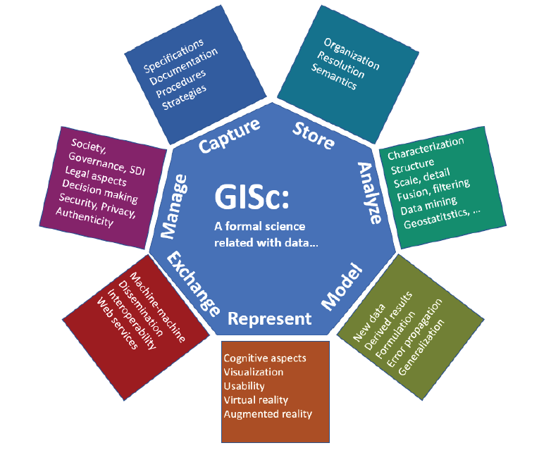
Figure 3 Illustration of the different main actions involved in GISc definition and some examples of the particular ones. Own elaboration.
This style of operational definition has already been tried for Information Science. For example, in line with Mark's (2003) idea of considering GISc as a specialization of Information Science, the definition of the latter attributed to Stock and Stock (2013) could be used, incorporating the term “geographic” after each mention of "information" leaving a definition that is also quite specific: “...GISc is an academic field which is primarily concerned with analysis, collection, classification, manipulation, storage, retrieval, movement, dissemination, and protection of geographic information...”
The definition that has been proposed reserves to GISc a set of activity areas, which can be compared with the proposals made by other authors. Specifically, Mark (2003) compared at the time the list proposed by Goodchild (1992) and by the UCGIS delegates meeting in 1996 (Research Priorities for Geographic Information Science University Consortium for Geographic Information Science, 1996) with his own proposal, and in Table 1 we will extend the comparison against the definition presented.
Table 1 Comparison between the topics usually considered for GISc and those included in the proposed definition
| Goodchild (1992) | UCGIS (1996) | Mark (2003) | This paper | |
| X | X | X | Ontology of the geographic domain | |
| X | X | X | X | Formal representation of geographic phenomena |
| X | X | Qualitative spatial reasoning | ||
| X | X | X | Computational geometry | |
| X | X | X | Efficient indexing, retrieval, and search in geographic databases | |
| X | X | X | Spatial statistics | |
| X | X | Other geocomputation topics | ||
| X | X | X | Cognitive Models of Geographic Phenomena | |
| X | X | Human interaction with geographic information and technology | ||
| X | X | X | X | Acquisition of geographic data |
| X | X | X | Quality of geographic information | |
| X | X | X | X | Spatial analysis |
| X | X | X | X | Geographic information, institutions, and society |
| X | X | Time | ||
| X | X | Scale | ||
| X | X | Distributed computing | ||
| X | X | Interoperability of geographic information | ||
| X | X | Spatial data infrastructure | ||
| X | X | Geospatial data mining and knowledge discovery |
Fuente: Own elaboration based on Mark (2003).
8. Discussion: why this definition
Operational definition. A broad and flexible definition can be useful to illustrate a topic and generate a concept, but it presents difficulties when applying it, since different individuals equipped with the same definition and faced with the obligation to discern whether or not something is from GISc will have too much margin for interpretation. For our purposes we prefer a more operational definition, which provides concrete clues to discern whether something is within the GISc topic or not. Admittedly, any delimitation of the scope of GISc will certainly generate complaints from those who feel affected, and that will be a price to pay.
Information from data. Using the word "data" within the definition (where the information is obtained just after processing) is nothing more than recognizing that there are GISc processes applicable when there is data with spatial coordinates, whether or not they are from sensitive space.
Avoid gerrymandering. The use of the word information is at the heart of criticism of GISc for gerrymandering. All geosciences use geographic information and the scope of GISc must be limited so that it does not unnecessarily invade other neighboring spaces. For this reason, it is proposed that GISc is a formal science, which processes data and obtains theoretical results without the need for application to the real world. When that application is made, it is already in the domain of empirical sciences, thus becoming information.
Formal Science. In this sense GISc, would be the only formal science within geosciences, which would explain very well the markedly multidisciplinary character that is already recognized. Our idea of GISc is that it deals exclusively with actions on spatial data carried out with formal tools without being interested in which domain science data belongs to or where they will be applied later. The results (finding hidden patterns, cleaning outliers, estimating ranges, etc.) will be later collected by empirical sciences to apply them in their own fields of interest.
Determination of job titles and skills. The GISc name has been around for quite some time, and it boasts undeniable popularity. Despite this, a satisfactory, non-expansive definition has not been achieved that avoids the risk of gerrymandering. The organization of teaching activities and the name of the degrees to be awarded require knowledge of the content taught. If an expansive definition is used in any of these actions, which explicitly or implicitly includes other already traditional geosciences, a resistance (or worse, misunderstanding) is generated among those affected, a fact which is clearly inconvenient. Even ISO found the need to offer a concise definition of Geomatics, a word with the advantage of being similar in several languages (French, English, German, Spanish, ...) which in addition is also present in the name of many institutions and academic degrees.
9. Conclusions
The precise and operational definition of GISc is a need that has been raised almost since the introduction of the term in 1992. One of the difficulties encountered was the lack of a delimitation of the scope of this science, which (according to Reitsma, 2013) in many cases will perform gerrymandering with other geosciences. Lacking an operational definition is inconvenient for several reasons. Here it is proposed that (for convenience) GISc should limit itself to manipulate Data and not Information, both concepts as defined in the DIKW paradigm. By separating GISc from contact with reality, its formal science character clearly emerges, such as Mathematics, Statistics or Computer Science has. We propose as a conjecture that the already familiar GISc is a formal science. Although there are also no fully established definitions of what a formal science is and what is not, it is possible to list a set of aspects that these sciences as well as GISc have, a fact which partly supports this conjecture. An operational definition related in style and structure to the ISO definition of Geomatics has been proposed that provides more objective criteria for deciding if some work is about GISc or not.
Funding
This research and APC were funded by IDEAIS Project-CYTED: Programa Iberoamericano de Ciencia y Tecnología para el Desarrollo, under Grant 519RT0579

