


 texto en
  Inglés (pdf)
 Artículo en XML
 Referencias del artículo
 Enviar artículo por email
 Citado por SciELO
  Similares en
SciELO
Similares en
SciELO 
 Permalink
Introduction
Since there is consistent evidence that animals do not forage resources available in their pasture area in a uniform way, an objective of animal grazing research is to understand the factors that could have an influence over animal movements, and their distribution on the territory.1-3 Information about the spatial distribution, habitat selection and preferential livestock locations opens a new way by which animal populations, both domestic and wild, can be managed with both conservation and productive purposes.
The use of Global Position System (GPS) devices to study the position of animals is a common technique in studies of wild animal’s habitats, such as deer, bears, and wolves.4-10 GPS devices have also been used for localizing and monitoring marine animals,11-14 studying the behaviour of female pigeons and dogs,15 and monitoring the position and velocity of horses during races or training, with the possibility of storing physiological data such as heart rate.16 Nevertheless, the application of GPS with the aim of developing better management practices on extensive livestock farming, is relatively recent. In the last 15 years this technology has been used for the study of different behavioral variables and monitoring of domestic animals: sheep,17-19 Iberian porcine,20 and cattle.21-36
General Packet Radio Service (GPRS) technology is used in mobile telephony and allows the transmission and reception of data from a terminal via packets. The traditional GSM networks (Global System for Mobile communications) do not adapt adequately to the needs of sending data with mobile terminals, so the GPRS technology unifies Internet Protocol (IP), with mobile telephony, creating an entire network, parallel to the GSM network and oriented exclusively to the transmission of data using the satellite telephone network.37 Currently, this technology is being replaced by the 3G and 4G systems, but in livestock management it is very useful, since the farms are generally outside the range of 3G and 4G networks.
The present work aims at applying the GPS-GPRS technology to monitor extensive cattle pursuing two main objectives: firstly, to validate a methodology that allows to obtain position data of the animals and their remote access via Internet for extensive cattle; and secondly, to analyze the information of animals’ positions to deepen the knowledge on the behaviour of grazing livestock, covering different aspects such as the circadian rhythms of locomotion and the use of the territory. We focus on the influence over the previously mentioned on pasture behaviour parameters of factors such as the available surface per animal, climate conditions and animals age. We anticipate that when animals have greater surface available, the percentage of surface used must be lower that when the surface is reduced; and that the climatological conditions must have an influence in the grazing circadian rhythms based on the temperatures and grass available.
Materials and methods
GPS-GPRS Devices and Web Platform for data collection.
The GPS device used in this study was developed by the AMENA Company and the University of Extremadura for pigs,20 being necessary to make a modification in the collar to adapt to the cattle’s neck, in order that the collar could be used by the animals without discomfort (Figures 1 and 2). The system comprises: a GPS receiver, which allows the determination of the animals’ position using the appropriate frequency, with a precision calculated by the manufacturer between 1 and 3 meters, an own power system (rechargeable batteries) and communication through GPRS with a communications center, in which data on real-time position is stored. The device allows the tele-programming of the interval of time during which it registers the geographical position. The ORANGE M2M internet platform allowed us to remotely access the geographic position data of those animals equipped with the transmission device through simple web access. The information obtained through the GPS device, and sent to the satellite receiver, was stored and reflected on the ORANGE web page. The set of positions can be viewed as points on a satellite photo of the chosen farm, and exported in a database, expressed in geographical coordinates (longitude and latitude). There is also information about the charge level of the devices’ batteries.


The combination of GPS-GPRS technology allows the transmission of information received by the GPS receiver, either at previously scheduled times, or continuously, so that complete information can be obtained in real time from the animal being monitored. In our case, we opted for a satellite frequency of twelve hours to extend the life of the batteries. During the study, some problems were detected with the frequency of emission of the data and the duration of the batteries in the case of one of the animals, this information was discarded for data analysis.
-
Physical environment - The farms studied are located in the province of Salamanca, in the southwest of the autonomous community of Castilla y León (Spain). With an average altitude of 823 m, it presents an inland Mediterranean climate with outstanding Atlantic influence. It is characterized by cold and semi-humid winters and hot, dry summers.
The farms chosen for the study are part of the natural ecosystem called “dehesa”, a flat or slightly undulating terrain, with vegetation composed of Quercus spp (oak, cork oak), and grassland species, where there are ponds and small streams.
-
Animals - In the extensive bovine cattle, we chose the fighting breed, as a representative of breeding in freedom. This breed presents some ethological peculiarities that make it difficult to manage and study its behavior,38 therefore, of special value is the obtained information.
Three animals were used in each gracing fenced area, all of them female, of which 3 were young animals (2 years), 6 were middle aged (3 to 7 years old) and 9 were older (8 to 16 years old), all belonging to 3 different farms from the province of Salamanca (Spain). Dominant adult animals were chosen within each group, guided by the livestock keeper’s criteria, so that their movements represented the entire herd.39 The collars were placed coinciding with management tasks that required the animals handling through the cattle crush, so that their manipulation for this work did not imply an additional stress. A total of 21 animals were monitored: 3 in the first protocol and 18 in the second one:
-
Protocol 1 Initially, a first working protocol was developed during the summer months in order to verify the proper functioning of the GPS device and the Orange platform to obtain the position data, distance traveled and geolocation on the satellite photography. It was also intended to observe the functionality and strength of the collar, the duration of the batteries, the behavior of the animal using the strange device, and find out that it does not alter its ethology and does not cause any discomfort or physical damage. To do this, three young animals, two years old, were chosen, assuming that they would be the most vulnerable throughout the study, as they could be affected by the weight of the GPS device (approximately 1 kg), which translates to 0.7 % of their body weight. The GPS collars were fitted to the animals for two months, with a positioning frequency of fifteen minutes. During this period, daily visualizations of the animals were performed at a distance with binoculars to compare the behavior of the animals monitored with the animals without GPS collar (Table 1).
Table 1 Features of the physical environment and animals studied.
Fenced area Area (ha) Features Monitored animals Total animals Livestock load (animals / ha) Age animals Period 1 10,5 Completely flat and devoid of trees 3 13 1,2 2 - 2 - 2 CP 2 26 Flat with low density oak tress 3 36 1,4 5 - 10- 13 WP 3 35 Minimum slope with a stream and good tree cover 3 45 1,3 4 - 9 - 15 CP 4 55 Small slope and woodland 3 30 0,5 3 -7- 16 WP 5 192 Higher slope an artificial pond 3 60 0,3 5 - 10 - 14 CP 6 200 Variable slope and several water points 3 55 0,3 4 - 12 - 13 WP Protocol 2 - The second protocol consisted of two working periods: the first during the months of April, May, June and July, which we call the warm period (WP); and the second period during the months of October, November, December and January, which we call cold period (CP).
-
Data processing and statistical analysis - With the set of positions expressed in geographical coordinates (longitude and latitude), compiled in a database, the home range areas were calculated, with the application of the program ArcMap® for animal movements: Hawth’s tool. Data were loaded on a georeferenced sheet with the ArcMap® program, using orthophotos of the study farms, obtaining images of the geographic dispersion of the animal and the trajectories covered by it. The distances between each position point taken with a frequency of fifteen minutes were calculated (Figure 3). This frequency was decided by taking into account the methodologies used in published studies.40-42

Travelling distance per se is not a good indicator of animal activity, however, accurate information on grazing, displacement and rest of livestock can be obtained with the data provided by GPS devices.35 The distance traveled should be close to zero for an animal that is resting, and large for an animal that changes its location.32 Thus, to interpret our results we relied on previous studies,43,32 where distances and speeds are related to observed grazing, displacement and rest behaviors. In our case, we did not obtain data of instantaneous speed therefore we cannot differentiate between grazing and displacement, but we can deduce the pattern of movement as a function of the total displacement for hours. Additionally, we must take into account that we assumed a downward error of the distances traveled and the detected activity, because in our protocol as in most of the works cited, we used frequencies of 15 minutes, and assumed displacements in a straight line between two consecutive locations.
In order to analyze the influence of light on the activity of the animals, the information provided by the company Tutiempo Network S.L., on light and dark hours throughout the study in the province of Salamanca was used.
Statistical analysis was performed with the SPSS V.20 program (IBM Corp. 2012),44 including one-way analysis of variance (ANOVA), linear correlation matrices with different independent and dependent variables, and post-hoc analysis using the Newman-Keuls test.
Results and discussion
The three GPS devices placed in eralas (2 years old females), for protocol 1, the verification of the good operation of the system and validation of the methodology, had an acceptable operation. Our results are in accordance with several authors who used a GPS collar system similar to ours, and did not affect the normal behavior of the species or its relationship with other individuals considering that the heifers behave as the rest of the herd after been fitted with the collars and this appreciation was made by direct observation by the researchers and the farm owners and workers.18,27,45,46,47
Use of territory
With the position data obtained in the monitoring period of each animal, we calculated the home range foraging area, i.e. the minimum convex polygon48 for each animal (Table 2); and as a surrogate of habitat use, we estimated the available space covered by the minimum convex polygon. The home range foraging areas was 56.0 ha on average, and was diverse and dependent on the available surface of the fenced pasture in which the animal was located. The smallest enclosures were almost completely (95 %) used by the animals, while the areas of animal breeding grazing in enclosures around 30 ha give us results of use close around 81 % of the available space. On the other hand, in the largest enclosure (number 6) with 200 ha we observed a use of around 60 %, by the three devices analyzed in the fence, which reflects that the use of the territory is dependent on the available area.
Table 2 Home range foraging areas obtained for each animal and percentage of occupied territory.
| Fence | Animal 1 (ha) | Use of territory (%) | Animal 2 (ha) | Use of territory (%) | Animal 3 (ha) | Use of territory (%) | Average territory | Use of (ha-%) |
|---|---|---|---|---|---|---|---|---|
| 1 | 10,26 | 97,71 | 9,31 | 88,67 | 9,81 | 93,43 | 9,79 | 93,27 |
| 2 | 24, 92 | 95,85 | 24,33 | 93,58 | 25,28 | 97,23 | 24,84 | 95,55 |
| 3 | 32,19 | 97,55 | 24,62 | 74,61 | 29,52 | 89,45 | 28,77 | 87,20 |
| 4 | 44,86 | 81,56 | 40,22 | 73,13 | 41,87 | 76,13 | 42,32 | 76,94 |
| 5 | 108,69 | 56,61 | 118,06 | 61,49 | 116,66 | 60,76 | 114,47 | 59,62 |
| 6 | 111,22 | 55,61 | 128,91 | 64,46 | 107,81 | 53,91 | 115,98 | 57,99 |
Thus, our results are in line with those obtained by Ganskopp,27 in a study of the movement of Hereford and Angus cows, using GPS collars, in a fenced area of 825 ha. This author obtained a home range area of 325 ha, corresponding to a degree of utilization of 39.4 %. Likewise, Barbari monitored 36 Angus cows obtaining a space utilization of 70.8 %, in small enclosures with good pasture of 2 to 3 ha.49 The home range found is 2.4 ha, which, despite the differences between studies in terms of available area and cattle breed, reinforces our results of less use of the territory in the largest enclosures.
Based on the results, we could think that the space available is greater than the one required by the animals to cover its vital needs in the case of fences number 5 and 6 (animals occupied only the 60 % of the territory). It is necessary to take into account the supplementation with forage and concentrate provided in the three farms, a fact that can influence the reduction of the times and spaces dedicated to grazing when sated their appetite. If the animal has a null herbaceous stratum and feeds on concentrate and forage, which is administered at a particular point on the farm, its movements in search for food will be concentrated in that environment.50 Thus, when there is good availability of grass, the dispersion of the animals is greater than at those periods when supplementation is needed, forming small groups.51
When we used large fences, unequal grazing can occur throughout the territory, which can reduce the carrying capacity of pastures and the efficiency of livestock production.22 In the larger areas of our study (numbers 4, 5 and 6) there may be less areas used by livestock, although with the monitoring of only three animals, even though they are considered representatives of the herd, we have to be cautious to determine which areas are underutilized because other animals not monitored could be using them. Authors argues that some management practices, such as strategic supplementation in certain areas of the farm, can modify animal behavior patterns to achieve a more efficient use of the available habitat, and thus correct the grazing imbalances, of the pasture area.52 Grazing activity is diminished when farms house many more animals than the land can hold.53 This is the case for smaller enclosures and greater stocking density: 1, 2 and 3. In this case home range foraging areas resulting from the animals monitored are similar to the dimensions of the enclosures.
Another factor that could influence the use of the land is the age of the animals, however, analyzing the areas of championship as a function of age, we did not find significant differences between groups: for young animals 68.78 ha (2 years old), 56.21 ha for the middle aged (3 to 7 years old) and 70.67 ha for the elderly (8 to 16 years old).
Biorhythms of locomotion
To know the habitual patterns of locomotion throughout the day, and therefore activity (circadian rhythm), the mean distances traveled per hour were analyzed, considering the mobility of all the animals across all samples (Figure 4). From 04:00 p.m. to the night, the animals exhibited a period of maximum activity, from 5:00 a.m. to 9:00 p.m., where the animals travelled around 300 m each hour. The intensity of the movements decreased in a period of intermediate activity from 10:00 a.m. to 1:00 p.m. (100 m. per hour approximately); and a second activity period, from 4:00 p.m. to 7:00 p.m., ending with a phase of minimal locomotive activity, from 20:00 to 3:00 a.m. (with average trajectories of approximately 50 m), when we supposed that the animals were resting. The hours with the highest activity were 6:00 am and 7:00 am which coincides with the sunrise. Therefore, in general it can be deduced that there are two periods of grazing: from 5:00 a.m. to 9:00 p.m. and from 16:00 a.m. to 7:00 p.m. (Figure 4).

Analysis of biorhythm gives us an idea of the moments of daily activity and rest. In our study we found a common trend of circadian biorhythms, maintaining a rest period of 7 hours that goes from 20:00 to 3:00 h, and in this interval the animals travelled less than 100 meters per hour. These results are in accordance with previous bovine observations made by Reppert,54 Sneva,55 Senft et al.56 and Broshv25) The rest of the day, the animals travelled from 100 to 600 m depending on the hour, with a peak of activity, of four hours, beginning at 5:00 am and ending at 9:00 am in the morning, which coincides approximately with the period of maximum activity found by Wilson.57 Ganskopp27 observed that cattle had a time dedicated to rest of about 10 h/day, and a time dedicated to the grazing of 11 h/day, although this author does not stated the daily distribution. Our results agree with this author joining the two rest and grazing periods. We also agree with Purroy,53 who mentions a time spent in eating food between 5 and 10 hours a day, and the rest of the time, about 10 hours a day, dedicated to rest. Similar results were obtained by Schlecht et al.47 whom reported a grazing period from 7.6 to 10.4 hours for extensive ruminants.
Considering the grouping of animals, accounting for the time of the year studied (CP and WP), we observed a very similar circadian scheme. Two moments of daily activity are clearly described, with a difference in the time frame of these moments, which are delayed in the cold period, compared to those observed in the warm period, with an offset of approximately 2 hours (Figure 4). In addition, the animals monitored during the warm period are the ones that travel the most during their period of maximum activity.
Taking into account the time of year, monitored animals describe a circadian rhythm of activity very similar to that published by Dolev et al.58 in a study comparing the biorhythm of two bovine breeds grazing in different fences during the four seasons of the year. Bailey et al.,21 meanwhile points out that most animal movements occur in the early hours of the morning, coinciding with dawn, usually between 6:30 and 8:30 a.m., August and September, which agrees with the circadian rhythm described by the animals monitored in the warm period (WP). In Bailey’s study,22 at 7:00 pm the animals moved to the rest area during sunset until the following morning, which would also fit our results, but an hour later (20:00 h). We also agree with the results of Schletch et al.,47 whom describe two grazing moments that would start from 7:00 am to 9:00 pm, and would end from 16:00 p.m. to 7:00 pm hours, for 88 % of their animals monitored.
Although most of the monitored individuals behave with a similar biorhythm, a clear influence of light and dark hours on the animals’ schedule is observed, acting on the time of beginning of their activity, which is earlier in the warm months and approximately 2 hours later in the colder months.34,59
In general, we can therefore consider the existence of two great moments of grazing, one at dawn and the other around sunset.60 Half morning and night are times to rest.57,60 In our case we observed the onset of the activity before dawn (6:00 a.m. during the CP and 4:00 a.m. during the WP), a small recess in the activity at noon (from 10:00 a.m. to 2:00 p.m. during the WP and from 12:00 to 15:00 h during the WP), and the end of daily activity at dusk (19:00 h in the CP and 21:00 h in the WP).
Parallel to the study regarding daily activity of animals, the most frequented areas were analyzed in different moments by means of a detailed observation of position images on the orthophotos of the farm. As result of this analysis, we observed that animals occupied three different zones of each fence, where they remained daily with displacements of less than 100 m for at least 1 hour in three different moments of use: food, drink and rest. This fact has been more clearly described in enclosures 5 and 6 (those of greater dimension), where it has been verified that the feeding zone is frequented during the moment of maximum activity (from 5:00 am to 9:00 pm), while the pond area corresponds to the second activity period (from 4:00 pm to 7:00 pm). Finally, the animals remain mostly in the rest area throughout the night (from 20:00 to 3:00).
Regarding the drink events and their duration, we observed that the animals in the enclosures 4, 5 and 6 were positioned around the water point, but we cannot establish the events duration. In the rest of the enclosures it was not possible to clearly distinguish these zones of different use in each moment of activity. Thanks to the detailed analysis of the geographic position images in enclosures 3 and 4, we can see that all three animals were independently recorded in area of the land, but they do not usually repeat their daily resting place; contrary to what happens in the enclosures 5 and 6, where the animals repeated their resting place during the study period.
According to Sickel et al.33 livestock grazing preferences are related to the amount of different herbaceous species present in the grazing area, but other factors such as the existence of ponds or drinking troughs, salt management points, and food supplementation also have influence.27,51 In our study, we observed different areas of preferential use in the enclosures studied, more defined in enclosures number 5 and 6, justified by a greater extent of land, however in the smaller surface enclosures (1, 2, 3 and 4) it has been impossible to differentiate this type of behavior, possibly because the scarcity of space means that not all the herd frequents an area at the same time, since this type of cattle maintains a hierarchical order in the herd and those who occupy the first positions are those who have first access to food or water.38 In addition, there is no a clear tendency for the positioning around a pond in fences 1, 2 and 3, a fact that we attribute to the presence of water in different streams over the fencing area since drink behavior is not established during a particular moment during the day. However, the majority of monitored individuals have moved to the pond once or twice a day, usually after the ingestion of concentrate (first hours in the morning), although this frequency may vary depending on the climatology.47,61
Daily distances traveled
Considering the distances daily traveled by the animals (Table 3) we obtained an average of 3147 m, with a minimum of 1829 m and a maximum of 4310 m. Distances traveled by animals in enclosure 1 were significantly lower than those of the animals in the enclosures 2, 3 and 4 (F 5,12 = 15.035, p = 0.0036); and in turn with the animals monitored in the larger ones (5 and 6) that experience greater routes. The distances traveled by the animals of the enclosures 2, 3 and 4 do not show significant differences among them, like the animals of the enclosures 5 and 6.
Table 3 Middle distances traveled by the animals in each enclosure studied average meters + Standard deviation.
| Fence | 1 | 2 | 3 | 4 | 5 | 6 | Average |
|---|---|---|---|---|---|---|---|
| Distance / animal / day (m) | 1829a ± 329 | 2191b ± 501 | 3209b ± 551 | 3312b ± 419 | 4031c ± 720 | 4310c ± 912 | 3147 ± 617 |
| n | 3 | 3 | 3 | 3 | 3 | 3 | 18 |
* Different letters indicate significant differences (F5,12 = 15.04, p = 0.004).
Table 3 shows large differences between the distances traveled by the animals as a function of the available space, with higher values being recorded in the larger areas (fenced 5 and 6), results in accordance with those reported by Ganskopp.27 The smaller distances recorded in the rest of the enclosures could be related to the smaller size and also the handling strategy to offer supplementary feed on the pasture, as Cibils et al. reported.17
The statistical analysis performed on the distances traveled daily did show significant differences (F 2,6 = 71.5, p < 0.001) among groups of animals of different ages (Table 4), with the oldest animals (3-16 years) being more actives than young ones. No doubt the influence of age on the hierarchical status of each individual has a great weight in this breed,38 since the defense and acquisition of the right to use space is fundamental in the herd hierarchy, and as we have mentioned, dominant animals were chosen to carry the GPS devices.53
Table 4 Distances traveled by the animals mean in terms of their age.
| Age | Young (2 years) | Average (3-7 years) | Advanced (8-16 years)q| |
|---|---|---|---|
| Distance / animal / day (m) | 1619a ± 401 | 3107b ± 678 | 3690b ± 794 |
| n | 3 | 6 | 9 |
*Different letters indicate significant differences (F2,6 = 71.48, p < 0.001).
At the same time, significant differences (F 1,16 = 49.91, p = 0.039) were observed in the distances traveled by the animals according to the studied period, considering the climatology and the solar cycle (Table 5). The longer duration of the day with a more pleasant temperature, coupled with lower pasture production during WP, could induce a need to graze for longer time to complete their nutritional requirements.
Table 5 Distances traveled by the animals mean in terms of the time of the year.
| Group | CP | WP |
|---|---|---|
| Distance / animal / day (m) | 2783a ± 807 | 3511,b ± 1049 |
| n | 9 | 9 |
*Different letters indicate significant differences (F 1,16 = 49.91, p = 0.039).
We have also analyzed the distances that each animal travels during the day and night according to the two studied periods (CP and WP) (Figure 5), taking into account the sunrise and sunset times for each month. Complementarily the average has been calculated with all animals. This analysis showed significant differences between day and night during the warm period and in the total average of all the enclosures (F 1,10 = 1178.78, p = 0.002).
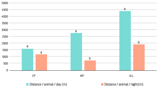
*Different letters indicate significant differences (F1,10 = 1178.78, p = 0.002).
Figure 5 Distances traveled by the animals during the day and the night.
We see that the distance traveled during the day is greater than that during the night, a tendency reinforced by the schedules of activity of the biorhythms described in Figure 4, where it is observed that the animals monitored rest mainly during the night, as other researchers point out.60 However, these results contrast with those published by Barbari (2005), in a study with 36 cows in 2 and 3 ha pens in Kentucky during May 2004, who observed different degrees of utilization between day and the night, being more extended the zone used during the night.
Taking the data according to the climatology of the studied period (CP / WP), during the CP there are no statistical differences between the distances traveled during day and night, but the distances traveled at night were statistically lower than the diurnal ones during the WP. Several factors can influence these results, firstly the duration of the light phase, which varies greatly depending on the month of the year considered (January = 9 hours / July 14 hours). On the other hand, a more pleasant temperature during the night can increase the nocturnal grazing.60 In our study, the animals monitored during the CP had a greater activity and began to graze very early (4:00 a.m.), two hours before individuals monitored during FP (6:00 h).
Finally, after verifying the results of monitoring and data collection via satellite, for visualization through the Web portal, we can infer that the use of GPS-GPRS technologies can be an alternative that reduces the time of permanence of the shepherds with the cattle that feed on vast natural territories. On the other hand, Rutter et al.19 and Aparicio et al.62 applying a similar technology in sheep and Iberian pig respectively, conclude that this technology is effective for the study of grazing behavior of individuals maintained in extensive regime. GPS-GPRS technology, supplemented by other sensors (e.g. temperature, luminosity, and pulsations), will increase the available information of the animal allowing a constant control of the herd and therefore of the production, growth and health of its members. The systems will allow not only to follow the animals but also to monitor their physiology, through additional information on factors such as heart rate, respiratory rate, body temperature, etc.
Conclusions
GPS-GPRS technology applied to monitor beef cattle is a good method for the study of grazing behavior, land use and spatial distribution. The obtained home range grazing area is around 56 ha, being influenced by factors such as grazing available surface. Cows tend to start their daily grazing activity a few hours before dawn, attenuating their activity with dusk and during the night. We also observed a marked nocturnal rest period, 7 hours of duration, and a tendency to frequent a certain area of the territory for such use. The mean daily distance traveled by the animals was 3147 m, with animals housed in larger enclosures performing higher grazing pattern and during the hours of sunshine. Animals older than 3 years traveled significantly more than younger cows. These results could be of relevance for a better pasture management using enclosures of size that increase the use of all the surface available.

