


 text in
  English (pdf)
 Article in xml format
 Article references
 Send this article by e-mail
 Cited by SciELO
  Similars in
SciELO
Similars in
SciELO 
 Permalink
INTRODUCTION
During the last decades, in North America grassland birds have continuously decreased their populations, more than any other group of land birds (Sauer et al., 2017; NACBI, 2016), this derived from the strong pressure of anthropogenic activities that they cause the loss and fragmentation of their habitat, lack of food availability, increase in predation, among other factors (Vickery et al., 1999, Panjabi et al., 2010, Martínez et al., 2011); This phenomenon occurs both on reproductive lands and in areas where they spend the winter, where the increase of the agricultural frontier is a determining factor in that effect (Pool et al., 2014).
For this reason, grassland birds are currently one of the groups that are attractive in the research on the biodiversity of pastures, since there are focal species that are indicators of the stability of ecological processes (Berlanga et al., 2010), this includes the creation of Priority Areas for the Conservation of Grasslands (APCP) of tri-national interest (CEC, 2005), a situation that stimulates the interest to increase the knowledge of the biology and ecology of these birds, allowing to design strategies of successful conservation (Igl and Ballard, 1999).
An example of grassland focal birds whose populations have been depleted are the grasshopper sparrow (Ammodramus savannarum) and Baird's sparrow (Ammodramus bairdii), which have an annual population growth rate of -2.5 and -2.0 % respectively. (Sauer et al, 2017. This is derived from long-term studies carried out on reproductive lands (counting of breeding birds in the USA), but information about their winter stay in Mexico is recent, and still scarce (Peitz, 2007), and details abundance and distribution (Martínez et al., 2011), large-scale winter habitat structure (Macías-Duarte et al., 2009) and winter survival (Macías-Duarte et al., 2017).
A close to ecological studies in wild birds, the vast majority include descriptors of vegetation characteristics, as indicators of the abundance and density of birds in places where they breed or overwinter (Johnson, 2007); where historically quantitative and qualitative methodologies have been used to evaluate habitat, soil cover and vegetation structure (Fisher and Davis, 2010); as they are: the frame of Daubenmire, which establishes a 20x50 centimeter quadrant located on a fixed transect and in it the interception with vegetation is recorded (Daubenmire, 1959); Robel's cane that uses the method of vertical visual obstruction, to measure density and ground cover (Robel et al., 1970) and the Wiens cane, which is used vertically with divisions every 10 centimeters, recording the number of times that it intercepts with vegetation to measure height and composition (Wiens, 1969); these are the most frequently used to know the structure of the vegetation, with relevant data; this with the aim of improving the understanding of habitat-animal relationships, through small-scale (<1m) or large-scale (> 100 km2) ranges and establishing effective conservation strategies (Vierling et al., 2008).
In this sense, remote sensing and remote sensing are currently a potential tool to characterize and analyze natural areas at various scales (Spanhove et al., 2012), and generate data that are used to map land cover and predictors of habitat models of organisms of different species (Gastón et al., 2017), including the group of grassland birds (Guttery et al., 2016), which reduces the bias of taking metric data or estimates in the field and covers a larger area of study in less time and cost; These are instruments that transform electromagnetic radiation into perceptible and analyzable information (Pérez, 2007). Concerning this, the UAS optimize the use of remote sensors for the ability to transport a wide range of sensors and equipment for taking images, as well as the capacity to receive and store information (Anderson and Gastón, 2013); and they also offer the opportunity to analyze the structure of the landscape at different spatial and temporal scales (Tommervick et al., 2014).
Therefore, the objective of this work was to characterize the vegetation and soil cover at detection points of sparrows A. bairdii (BAIS) and A. savannarum (GRSP) during their winter stay, in the area of the Priority Area for Conservation of Grasslands of Cuchillas de la Zarca, using two different methodologies: a) Protocol of visual estimation established by the Bird Conservancy of the Rockies (BCR) of conventional vegetation sampling; and b) High resolution images obtained through a UAS, to explore the feasibility of its use; under the assumption that both methodologies yield similar results.
MATERIAL AND METHODS
Study area
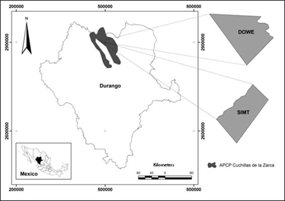
The project was developed in two sites of natural pasture delimited within the Region of Cuchillas de la Zarca (CUZA); the first named DOWE, with an approximate area of 180.36 hectares; and the second SIMT, with an area of 137.96 hectares; located between the extreme geographic coordinates 26° 20'11.24"N, 105° 10'58.11" O at 26° 17'5.98 "N and 105° 9'15.35" W (figure 1).
The vegetation consists mainly of scrub (91%) and natural pasture (9%), with grass species such as Bouteloa gracilis, Bouteloa curtipendula, Chloris virgata, among others. The shrub layer is mainly constituted by Acacia spp., Opuntia spp., Prosopis spp. Junniperus ssp, Brickellia spinulosa and Ephedra spp (Rzedowski, 1981).
Bird capture
For the capture of birds were used 4 fog nets of 12 meters long and 2.60 meters high black polyester model KTX of Avian Research Supplies, AFO, 36 millimeters mesh, and the help of eight people to use the method of drove the birds to the net (Panjabi and Beyer, 2010). After the capture, each of the birds was placed a size 1 metal ring of the USGS (United States Geological Survey), for identification and the zoomometric measurements were taken. Later, a transmitter model PicoPip 379 of LOTEK®, weighing 0.5 grams, with a battery life of approximately 40 days, was placed with an elastic harness (Rappole and Tipton, 1991).
Monitoring of birds
During the entire winter period from December 12th, 2016 to March 15th, 2017 (94 days), the daily visual location of each individual was made by telemetry with the help of an ATS radio receiver (Biotrackers®) and headphones. (David Clark® model H10-00-4); which detect the radio signal of the transmitter. Once located, the registration of the coordinates of its location was taken with the help of a GPS navigator brand Garmin® model Vista. The previous procedure allowed elaborating a database of points of location of individuals of the two species in the study, to generate a series of random numbers and to select the locations by species and by site.
Vegetation sampling using the Bird Conservancy of the Rockies protocol (BCR)
For the collection of vegetation data, the protocol was used (Macías-Duarte and Panjabi, 2013); which consists of tracing a circle of five meters of radius on the central point of the location of the bird monitored and making a visual estimate of the coverage percentage (%) and height in centimeters (cm) of the variables grass, shrubs and bare ground (including rocks smaller than a fist); as well as other coverings (rocks, mulch and woody material), from which vegetation characteristics were selected that were used to compare with the method of classification of high resolution images.
High resolution images obtained by UAS flights
The high resolution images were obtained through the S110 NIR® camera (Green, Red and Near Infrared Channels), placed in a UAS eBee ®; a flight was made at each site, at a height of 110 meters. An orthomosaic with resolution of 5 centimeters per pixel was generated from each flight. Subsequently, a supervised classification was carried out in the ERDAS IMAGINE ® software, by means of spectral signatures of each element in situ; that is, a process in which the known identity pixels (classes) are used to classify pixels of unknown identity. In the training stage, the following classes were selected: grass, shrub, bare ground and shade. In the image, polygons corresponding to each class were digitized, whose numerical data are stored in the software as regions of interest; constituting the "training areas". Once a set of such areas is available, each of the pixels in the scene is assigned to some class, according to the procedures established in Richards (1999).
Based on the above, a classified image of the entire area was obtained with the classes of grass, shrub, bare soil and shade. In order to have a scale equal to that used in the conventional methodology of the Bird Conservancy of the Rockies; at each location point of the selected birds a buffer of 5 meters radius was generated to calculate the coverage percentage of each of the classes in the area of the circle. This process was performed in ESRI® ArcMap v10.5 software.
Statistical analysis
The distribution of the data obtained did not comply with the precepts of the normal distribution; therefore, the analysis was performed using the non-parametric method of Kruskal-Wallis, for each methodology (BCR, UAS), by site (DOWE, SIMT) and by species (BAIS, GRSP), for the response variables that were achieved obtain in both methodologies: grass cover (%), shrub cover (%) and bare soil (%), with the use of the statistical package Number Cruncher Statistical Systems® (Hintze, 2001).
RESULTS
During the 2016-2017 winter, in the area of Cuchillas de la Zarca, with the use of telemetry and the monitoring of 56 birds of the Ammodramus genus (33 BAIS and 23 GRSP), 1881 georeferenced localization points were recorded, of which they randomly selected ten by species (n = 2) and by site (n = 2); obtaining as results the tables presented below:
Table 1 Kruskall-Wallis analysis of vegetation and soil cover variables in two sites of the Priority Area for the Conservation of Grasslands Cuchillas de la Zarca, with data obtained by supervised classification of high resolution images and vegetation protocol Bird Conservancy of the Rockies. 2016-2017 Winter season
| BCR Methodology | Place | |
|---|---|---|
| Variable | DOWE (n=20) | SIMT (n=20) |
| Grass cover (%) | 73.55±1.55a | 82.8±1.55a |
| Bare soil (%) | 8.3±1.02a | 6.25±1.02a |
| Shrub coverage (%) | 5.4±0.86a | 4.9±0.86a |
| Methodology high resolution images | Place | |
| Variable | DOWE (n=20) | SIMT (n=20) |
| Grass cover (%) | *72.31±3.98a | 52.31±2.87b |
| Bare soil (%) | 25.42±4.07b | 35.96±2.96a |
| Shrub coverage (%) | 0.69±0.17b | 3.44±1.17a |
| Not qualified | 0.68±0.15b | 8.29±2.46a |
* Different literals between columns represent significant differences (p≤0.05, Z≤1.96)
It is highlighted that the vegetation variables evaluated by the conventional methodology of the Bird Conservancy of the Rockies, where it uses the technique of visual estimation of the observer, there are no differences between the sites. On the other hand, in the analysis of the high resolution images, differences are observed for all the variables between both sites, classifying as bare soil a greater number of pixels, so this category increases remarkably compared to the Bird Conservancy of the Rockies methodology.
Regarding the analysis of the variables studied by both methodologies in sparrow localization sites of the genus Ammodramus (table 2), it is observed that there are no significant differences between species, which suggests that the use of high resolution images obtained by UAS is feasible to characterize the habitat of both species.
DISCUSSION
In ornithology, most studies that talk about habitat characterization of different bird species are directly related to the study of vegetation structure variables, and those that characterize specific sites used by birds are uncommon (Johnson, 2007); this is very relevant when we study habitats and species that are threatened, such as the ecosystem and grassland birds (Berlanga et al., 2010); since they must comply with several desirable characteristics, such as precision, effort and cost (Sutherland et al., 2004).
The results obtained (table 1), indicate that there are significant differences between the two methodologies, when analyzing the two sites (DOWE and SIMT) for the study variables; highlighting that the high resolution images establish differences between both places of study, a situation that differs under the analysis of the Bird Conservancy of the Rockies methodology; on the one hand, because the observer in the BCR methodology performs the estimation by looking at the height of his eyes, and this, when replicated up to hundreds of times (each location), becomes a constant estimation pattern, in which to underestimate or overestimate, this is known as human error (human bias) (Bibby et al., 1998).
Table 2 Kruskall-Wallis analysis of vegetation and soil cover variables in two species of the Ammodramus genus, from the Priority Area for the Conservation of Grasslands Cuchillas de la Zarca, with data obtained through the supervised classification of high-resolution images and Bird Conservancy of the Rockies vegetation protocol. 2016-2017 Winter season
| BCR Methodology | Species | |
|---|---|---|
| Variable | BAIS (n=20) | GRSP (n=20) |
| Grass cover (%) | 78.15±1.94a | 78.2±1.94a |
| Bare soil (%) | 7.45±1.02a | 7.1±1.02a |
| Shrub coverage (%) | 5.65±0.85a | 4.65±0.85a |
| Methodology high resolution images | Species | |
| Variable | BAIS (n=20) | GRSP (n=20) |
| Grass cover (%) | 61.24±4.07a | 62.78±4.24a |
| Bare soil (%) | 34.65±3.69a | 26.74±3.50a |
| Shrub coverage (%) | 1.39±0.24a | 2.74±1.22a |
*Literales distintas entre columnas representan diferencias significativas (p≤0.05, Z≤1.96)
On the other hand, the methodology of high-resolution images was taken at high altitude, offering a vision without obstacles. However, human error is not absent despite the use of high technology, since it lies in the ability of the classifier to assign similar values at the pixel level, and associate them in classification categories; and on the other hand to the correct processing of the images (Richards, 1999). Small-scale studies have been carried out in various groups of animals, such as terrestrial mammals (Stirnemann et al., 2015), and to select areas for the conservation of different species (Heinrich et al., 2017).
We consider that the most important finding in this study is that by analyzing the vegetation variables in localization sites for each species of the genus Ammodramus, no significant differences were found between the two species, by either of the two methods; which indicates that both methodologies are useful for characterizing the habitat of grassland bird species; however, in terms of time-precision efficiency, we consider that the use of remote sensors to describe small-scale grassland habitat is more efficient than visual estimation. On the one hand, the methodology of the Bird Conservancy of the Rockies has been proven in several studies of wintering birds (Panjabi et al., 2010, Martínez et al., 2011, Macías-Duarte and Panjabi, 2013, Macias-Duarte et al., 2017); however, the use of high-resolution images would have been used to describe general aspects of large-scale grassland habitat (landscape level) in the same study region (De León-Mata et al., 2014; Rodríguez-Maturino et al. , 2017) representing this study a first attempt to describe specific sites used by grassland birds.
In the same sense, there are descriptions of the characteristics of the vegetation and soil cover, which A. bairdii uses during its winter stay in the Chihuahua Desert; where Martínez et al., (2011), during three winters (2007-2009), found that this species was located in sites with an average coverage of 66.9 ± 1.34% of pastures, 1.79 ± 0.024% of shrubs and 11.1 ± 0.85% of bare soil, similar to those found in this study by both methodologies. Likewise, Macías-Duarte and collaborators (2011) relate the highest density (individuals / km2) in grass cover greater than 60%, in a study carried out in ten Priority Areas for the Conservation of Chihuahua Desert Grasslands.
For the case of A. savannarum, the results found by both methodologies are similar to those described by Vickery (1999), where in turn, Macías-Duarte and Panjabi (2013), associate the higher density of A. savannarum to grass cover greater than 60%, and shrub coverage between 5% and 10% (Ruth, 2017); that agree with the results obtained in the present study and that have an explicable biological basis according to the theoretical sustenance that describes the habitat of both species.
CONCLUSIONS
The use of high-resolution images taken by UAS flights proved to be feasible to describe the small-scale habitat of A. bairdii and A. savannarum in areas of bird use for three of the most important land cover variables. in wintering sites (grass cover, bare ground cover and shrub cover); since results similar to those of the BCR protocol were obtained, but this method is more efficient in time, effort of work, cost of monitoring, reduction of the bias of metric data obtained in the field and presenting a lesser disturbance to the species and the ecosystem .
The information obtained with these methodologies is very useful from the point of view of the ecology and conservation of the birds considered in this study; and it is important to highlight that the use of remote sensors represents a novel option that allows innovations to be incorporated into research, and that it offers opportunities to develop lines of research in Mexico on the use of remote sensors to expand knowledge on the description and use of habitat of different animal species, as well as solve problems with respect to the environment.
This study represents the first attempt in Mexico to characterize the winter habitat of birds of the genus Ammodramus, in specific sites of bird use, using high resolution images taken with UAS; so the use of this geospatial technology has great potential in future research of grassland birds.

