


 nueva página del texto (beta)
 Inglés (pdf)
 Artículo en XML
 Referencias del artículo
 Enviar artículo por email
 Citado por SciELO
  Similares en
SciELO
Similares en
SciELO 
 Permalink
Introduction
Cucapá indigenous people have historically inhabited the Colorado River Valley. Recent archeological evidence reports settlements from ~1670 ad1 (Porcayo et al., 2016). For this community, the river was both the provider of tools, food and shelter, as well as the pillar for intangible cultural elements such as the Cucapá worldview, myths and symbolisms (Reisner, 1986; Chan et al., 2012; Axelsson et al., 2013). However, the fast colonization of the Colorado River Delta beginning in the 20th century lead to the degradation of the ecosystem (Samaniego, 1998; Ward, 2003; Porcayo et al. 2016). It was in 1931 when a second major drought affected the river's delta, causing the river-based economy of the Cucapá people to break, forcing them to gradually embrace capitalism (Samaniego, 1998; Gómez Estrada, 2000). Table 1 provides a chronological guide of the main events that have influenced Cucapá livelihoods in the past 500 years.
Table 1 Key events in the past 500 years in the history of the management of the Colorado River Basin and the Cucapá indigenous people
| Key historical events in the Colorado River Delta social-ecological system | ||
|---|---|---|
| Historical and holistic period | 1500 1800 | Exploration and attempt of colonization of the Colorado River Delta by religious orders (Bonilla Vázquez, 2011). |
| 1848 | Signing of the Treaty of Guadalupe-Hidalgo and Gadsden Purchase (Ward, 2003). | |
| 1853 | Cucapá people territory became binational. | |
| 1874 | Guillermo Andrade acquired the Colorado River delta territory (Samaniego, 1998). Cucapá people were legally dispossessed but still free to use the territory in the traditional way (Gómez Estrada, 2000). | |
| 1880 | Mexican attempts to colonize the area failed, and most of the population in the delta were still indigenous people (Sykes, 1937). | |
| Transition period | 1905-1907 | First major drought in the Colorado River Delta due to the deviation to irrigate Imperial and Mexicali valleys. Cucapá people were unable to sustain their traditional economy and use of natural resources and forced to join the market economy (Gómez Estrada, 2000). |
| 1917 | Settlement of the Cocopah Tribal Reservation in Somerton, Arizona, us. Free access to and use of the river's resources was banned in us (Kelly, 1977; Tisdale, 1997). | |
| 1920 | Cucapá people on either side of the border preserved their semi-nomadic lifestyle and some of them were still engaged in traditional agriculture (Gómez Estrada, 2000). | |
| 1930-1934 | Second major drought in the Colorado River Delta due to lack of runoff in the upper basin of the Colorado River and the construction of Hoover Dam (1931-1935) (Gómez Estrada, 2000). Agricultural drainage into the Hardy River begins (Ward, 2003). Techniques for food provisioning, ceremonies, rituals, and legends no longer regularly practiced or taught to new generations (Gómez Estrada, 2000). | |
| 1936-1937 | The US prohibited the free border crossing of Mexican and North American Cucapá and all indigenous people (Gómez Estrada, 2000). Cucapá people were forced to abandon their semi-nomadic lifestyle and live in community as a result of the reforms on agricultural and land policy driven by the Mexican Federal Government (Ward, 2003). Establishment of Cucapá Indígena and Cucapá Mestizo villages and the settlements at the banks of the Hardy River that in 1980 formed the El Mayor village (Álvarez de Williams, 1974a; Gómez Estrada, 2000). | |
| Consolidation period | 1940 | The Hardy River became a tourist destination for North Americans. El Mayor people became tourist service providers (Albro, 2013). |
| 1942 | Establishment of the Pozas de Arvizu village on land granted to us Cucapá citizens by the The Colorado River Land Company (Rodríguez, 1976). | |
| 1944 | Signing of the binational water treaty 'Utilization of Waters of the Colorado and Tijuana Rivers and of the Rio Grande" (known as the 1944 Treaty) that established a water allocation to Mexico from the Colorado River of 1 850 234 000 m3 and specifies the conditions of its distribution (TILA, 1944). | |
| 1954 | Up to this year, Morelos Dam (last dam along the Colorado River settle in Mexican territory build between 1948-1950) received over 2.466 mill/m3 even though in the 1944 Treaty, the water allocation for Mexico was lower: 1.850 mill/m3 (Ward, 2003). | |
| 1958 1983 | Third drought in the delta due to the building of Glen Canyon Dam and filling of Lake Powell (Stockton y Jacoby, 1976; Glenn et al., 2007). | |
| Meeting population needs i | 1980 | Flooding of the Colorado River Delta. Ecological conditions improved (Glenn et al., 2007). Houses settled along the river were abandoned and the El Mayor village was created (Leonor, interview, 2014). |
| 1987 | First permit for commercial fishing in fresh water, granted for El Mayor inhabitants (Bárbara, interview, 2014). | |
| The degradation begins | 1990 | Fresh water fishing declines (Bárbara, interview, 2014). Beginning of fishing in El Zanjón (Sabrina, interview, 2014). |
| 1993 | Declaration of the "Biosphere Reserve of the Upper Gulf of California and Colorado River Delta" (NPA) (CONANP, 2007). | |
| 1998-1999 | The Colorado River no longer reaches the Gulf of California (Mapa de la tierra de los Cucapá, 2009). The fight for fishing rights in the NPA begins (Leonor, interview, 2014). | |
| Skeptical perception of water quality and restoration strategies | 2007 | The discharge of wastewater from the Las Arenitas Treatment Plant into the Hardy River begins (García-Hernández et al., 2009; Albro, 2013). |
| 2010 | Earthquake in Mexicali. The topography of the Hardy River was affected as well as the irrigation modules that fed the Hardy River. Several tourist camps were abandoned and the path to El Zanjón was damaged (Trejo Fernandez, 2012; Albro, 2013). | |
| 2012 | The Las Arenitas artificial wetland began to operate, improving the drainage into the Hardy River (García-Hernández, 2013). Nevertheless, for El Mayor people the water is polluted and poses a threat to health (Bartolo, interview, 2014). | |
| 2014 | Beginning of the pulse flow as stated in Minute 319 of the 1944 Treaty (CILA, 2012). On May 15, the Colorado River reached the Gulf of California after 54 years of irregular flooding patterns (since 1960) (IBWC, 2014). |
Source: Prepared by the authors.
With the impossibility of using the river as a resource provider, the necessity to find a paid job and the pressure from the US and Mexican governments to control indigenous people, Cucapá people were eventually forced to abandon their nomadic lifestyle and settle down (Álvarez de Williams, 1974a; Kelly, 1977; Gómez Estrada, 2000). Nowadays, the Cucapá population is around 1 500, spread in three main settlements and other areas within the southern states of the US and northern Mexico. The three main settlements are: 1. the Cocopah Indian Tribe in Arizona, us with 1 000 members (Cocopah Indian Tribe, 2014), 2. Pozas de Arvizu, Sonora, Mexico (Luque, 2012) with 100 inhabitants and 3. El Mayor, Baja California, Mexico with 174 inhabitants (information obtained during fieldwork).
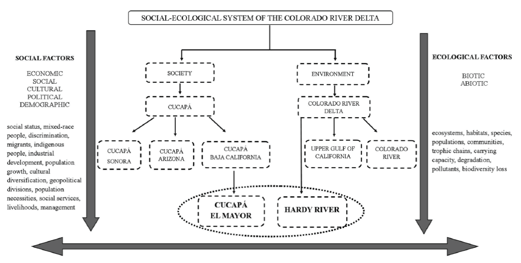
In this investigation, we use the Social-Ecological Systems (SES) framework as the basis for analyzing and understanding the relationships and interactions between Cucapá people and their surrounding environment. According to Berkes and Folke (1998), in a SES, biophysical and social (in its broader sense) factors are linked through complex feedback mechanisms in continuous adaptation. Cucapá settlements and the Colorado River Delta thus form a SES in which political, economic, social, cultural, and ecological events have undoubtedly influenced Cucapá people livelihoods (Figure 1).
Source: Prepared by the authors.
Figure 1 Diagram showing some of the elements included in the Social-Ecological system of the Colorado River Delta (SES - CRD )*
* Arrows downwards and the double arrow indicate that social and ecological factors interact with all the elements inside the SES, with those interactions continuously changing through time creating the co-evolutionary system of the Cucapá and the Colorado River. El Mayor people and the Hardy River (circled) are sub-systems of the SES-CRD, but at the same time, they constitute a SES itself. Thus, in this research the SES under study is integrated by El Mayor population and the Hardy River feedbacks (SES-MH), under the question: how degradation factors upon the Hardy River have influenced El Mayor people livelihoods. Key facts in the history of the SES-CRD are described along the text as a basis to better understand how the whole system has evolved.
El Mayor is located at the banks of the Hardy River, this village is unique in that it is the only one of the main Cucapá settlements located in part of the Cucapá historical territory, a sacred place. Although El Mayor in its current location was established until 1980, this settlement has its origins in 1937 when Cucapá people were forced to stop their semi-nomadic lifestyle and some families established along the banks of the Hardy River (Table 1). Thanks to the consistently better ecological conditions throughout the years in the Hardy River compared with the Colorado River main channel, the population in El Mayor continued to extract natural resources for longer than the other settlements (Table 1). Thus, from the second half of the last century (1940) until the period when this research was conducted (2013-2014), there were clear and specific degradation factors upon the Hardy River whose consequences on Cucapá inhabitants of El Mayor are the object of this research (Figure 1). Using the case study of El Mayor inhabitants we seek to provide a better understanding of how the transformations on ecosystems influence indigenous livelihoods, how new mechanisms and resources are adequated to alleviate one population's tangible and intangible necessities and the associated transformation of values over the territory.
Methods
El Mayor Cucapá village, located at km 57 of the Mexicali-San Felipe highway, belongs to the district of Venustiano Carranza (INEGI, 2017), Mexicali, Baja California, Mexico. El Mayor village covers an area of 77 m2 with approximately 85 houses (Figure 2, Figure 3). Field work lasted for a year, divided into three main stages: 1) July 2013, participant observation and informal conversations were held, 2) December 2013, semi-structured interviews were applied, 3) July 2014, the El Mayor people were informed that the research had concluded, and some data were verified with key informants. Short visits were also made throughout the year to witness key events such as the traditional celebration, fairs, ceremonies, and the fishing season. Pozas de Arvizu and The Cocopah Indian Tribe were also visited.

Source: Prepared by the authors based on data supplied by the National Institute of Geography and Statistics (Instituto Nacional de Estadística y Geografía-INEGI) [shapefile] 2013, Geoestatistical Frame version 6.0, INEGI, National Commission of Natural Protected Areas (Comisión Nacional de Áreas Naturales Protegidas-CONANP) [shapefile] 2014, Upper Gulf of California and Colorado River Delta, Conanp and 2013-2014 field work over ESRI, 2014 with the assistance of Norma L. Rangel Valadés.
Figure 2 Social-Ecological System under analysis; map of the Colorado River Delta showing key points for Cucapá indigenous people
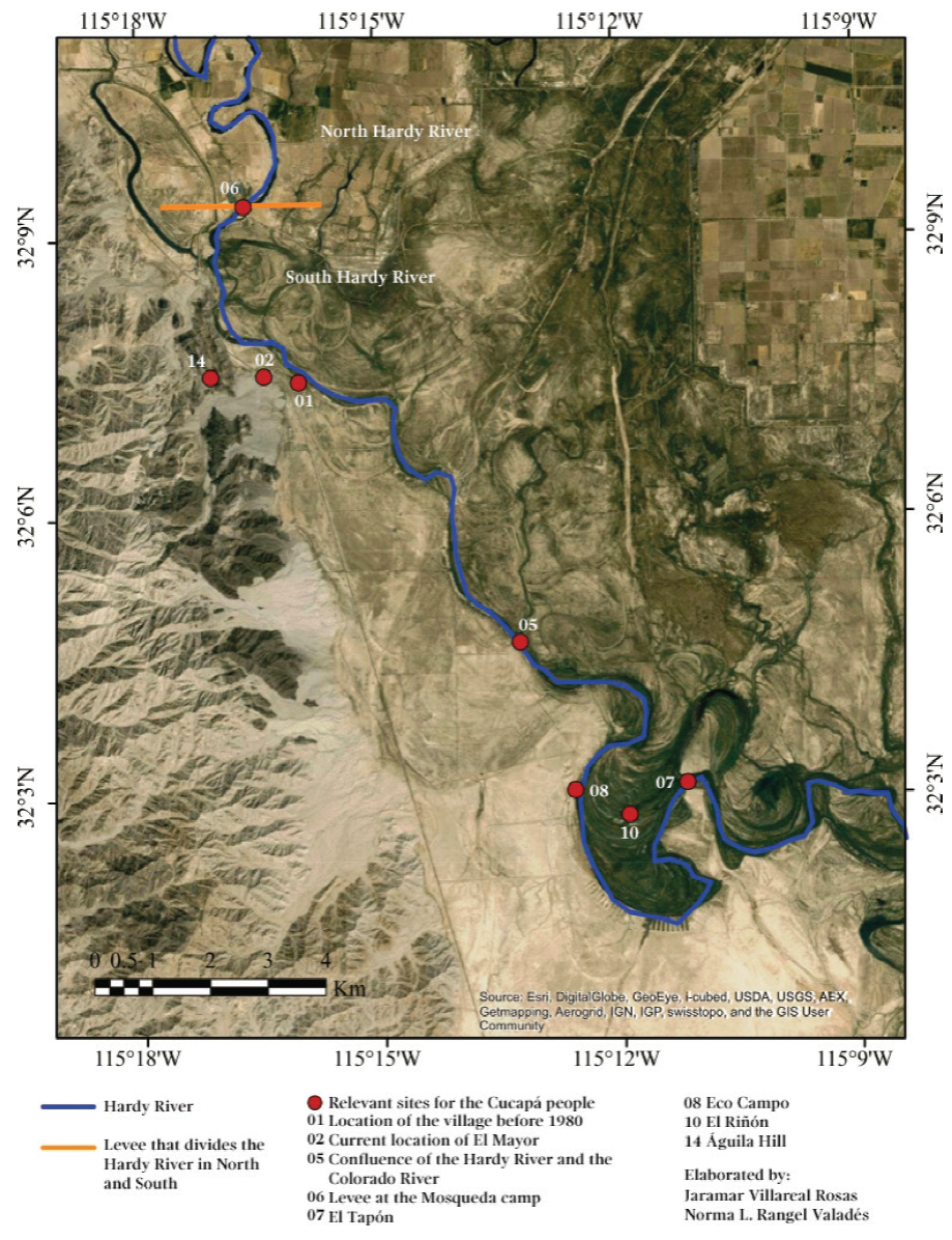
Source: Prepared by the authors based on data supplied during 2013-2014 over ESRI, 2014 with collaboration of Norma L. Rangel Valadés.
Figure 3 Map of the Hardy River with key sites for the Cucapá indigenous people highlighted
Interviews were applied to people belonging to different age groups in accordance to the intentional sampling criterion (Anduiza Perea et al., 1999).2 Information obtained through the interviews, field diary and informal conversations was analyzed based on the grounded theory technique (Trinidad et al., 2006). Information on the environmental degradation of the Hardy River was obtained through bibliographic compilation with the assistance of civil society and government organizations until the saturation point of information was reached. It is important to note that along the text we will use the term 'Cucapá people' to refer to all the Cucapá population when they still had a semi-nomadic lifestyle, while the term 'El Mayor people' will be used to specify the population that settled along the Hardy River banks around 1930-1940 and that later on created the El Mayor village.
Degradation of the hardy river
Tourist camps on the Hardy River: the consolidation of a new approach to the river, 1940-1980
From 1900 to 1940 Cucapá people experienced a transition in their livelihoods strongly influenced by the environmental conditions that the Colorado River Delta had along those years. Historically, they had a holistic use of the river (a detailed description of Cucapá people before 1900 is beyond the scope of this research, however, Cucapá historical livelihoods could be found at Álvarez de Williams, 1974b; Álvarez de Williams, 1975; Kelly, 1977; Gómez Estrada, 2000; Porcayo et al. 2016). Nevertheless, after facing two major droughts, from 1905 to 1907 and from 1931 to 1935, together with other degradation events (Table 1), Cucapá people were unable to continue with their river-based provision of resources (Tisdale, 1997; Samaniego, 1998; Gómez Estrada, 2000; Porcayo et al. 2016). As a parallel process, the river provision of intangible livelihoods also changed. Ceremonies, rituals, and legends were no longer regularly practiced or passed on (Gómez Estrada, 2000).
The construction of Glen Canyon Dam and filling of Lake Powell provoked a third major drought that lasted from 1958 to 1983 (Stockton and Jacoby, 1976; Glenn et al., 2007). Despite the desolated environmental conditions in the Delta, the Hardy River received two extra water contributions: 1) drainage from the agricultural valley of Mexicali that runs through the Hardy River since 1930 (Ward, 2003) and 2) over 2 466 mill/m3 received at Morelos Dam until 1955 that were directly discharged to the Hardy river (Ward, 2003). With these water contributions, environmental conditions in the Hardy River were sufficient to provide food and other resources that El Mayor people had direct access to in the event of economic scarcity. For example, they gathered pechita (mesquite pods) and the center of the common rush, they hunted rabbits and drank water directly from the river (Yazmin, interview, 2014, 78 years old). El Mayor people interviewed recall this period with nostalgia and before all the degradation factors started, when fishing was solely to meet their own needs and the river was the physical space were most of the learning and socializing was made when they were children.
"When I was hungry, if I had an old throw net I used it to fish, and I ate what I caught, without tortillas or lard, nothing else, nothing" - Yazmin (interview, 2014, p. 150, 78 years old).
The beauty of the Hardy River attracted tourism from California and Arizona, the owners of the land nearby the river started renting lots for RV parking, that eventually turned into camps (houses for rent) (Albro, 2013). El Mayor people, on the other side, couldn't meet their needs only with the extraction of natural resources. This is how the establishment of tourist camps along the Hardy River in the early 1940s became a secure and constant income for El Mayor people, although some of the population also found employment picking cotton. Among the activities that El Mayor people developed in the touristic camps were: keepers of the houses while the owners were away, worked as servants, guides, guards, watchmen, cleaners, cookers and helpers. Shops were settled around to offer food and services such as tire repair, boat and Jet Ski rent (Albro, 2013).
"It was so pretty, there were lots of trees, bigger than this [points to a lamppost], we climbed up the branches and from the top we dived into the middle of the river. And then we played to see who could dive in and come out of the water on the other side of the river [...]. I was about 6 years old and my other brothers were about 9 years old or less and my brother was about 12. It was so wide [the river] it was as wide as from here to the church, ships could sail on it" -Yazmin (interview, 2014, p. 152, 78 years old).
The period from 1940 to 1980 represents the consolidation of a transition process in Cucapá culture, with clear transformations in the interactions inside the Social-Ecological system of the Colorado River Delta (SES-CRD) (Figure 1). Beginning with what we are naming as the 'Holistic period' in which the Colorado River was the basis of world view, the space for social interaction, rituals, and ceremonies, as well as the provider of personal care resources, food, tools, medicine and all aspects of Cucapá living (Table 1). Passing through the 'Transition period' in which the complex links in side the SES-CRD where drastically transformed in a parallel process to the fast colonization of the delta region (Table 1), and finally reaching a 'Consolidation period'. The first two periods refer to wider processes affecting the whole Cucapá culture and population, this categorisation, although may be considered as over simplified, helps understand the context under which El Mayor people livelihoods are analysed.
It is from the 'Consolidation period' that we start refering to El Mayor people, in clear recognition that from 1940 the social-ecological factors for this village were unique, and required an independent analysis from the other Cucapá settlements (Table 1, Figure 1). By this period, El Mayor people were already dependent upon the market economy with the direct extraction of resources (by then reduced mostly to fishing and gathering) converted into a complementary or recreational activity, and the ritual life including war or adulthood ceremonies inexistent (Table 1). Nevertheless, it should be highlighted that the Hardy River was still strongly regarded as a vital historical space to learn about Cucapá cosmology, about the river resources and stories of its richness and greatness, as well as a social space for community interaction and housing (Table 1).
Environmental events: changes in El Mayor livelihoods, 1980-2014.
From 1979 to 1989 excess flows at the Colorado Basin caused flooding in Mexico. The reasons for the excess water were, first, that Lake Powell in Glen Canyon Dam finally reached its storage capacity. Second, the meterological events of El Niño that provoked over rains and snows along northwest us (Glenn et al., 2007). As a measure to prevent the collapse of different dams over the US, huge quantities of water were allowed to flow in the Colorado River natural channel (Piechota et al., 1997). For the environment, this meant the recovery of approximately 600 million m2 of wetlands and riparian vegetation (Glenn et al., 2007). El Mayor people, however, recall 1980 flooding as the event that forced them to change their last 40 years of interactions with the Hardy River, even though the population recognize the benefits the extra water brought to the environment the first years after the flooding.
This section is divided into four specific events that El Mayor people indicated as factors that gradually changed the environmental conditions in the river, and with it their livelihoods.
The flooding of the Colorado River affected us greatly. First it was a benefit but eventually it left us in a situation that really affected us. For me and for the people that used to fish here, the period when there was water in the Salada Lagoon was beneficial. It was like a 10 years' flood in the whole area. It was necessary to move the highway because the water went as far as the old highway, so they raised the highway. But in the end, it was a disaster. The river channel changed, and then it got blocked, it was deep and then it got blocked ending up being short - Bárbara (interview, 2014, p. 156, 50 years old).
Flooding of the delta: meeting El Mayor people's needs, 1980-1990
The consequences of the flooding of the Colorado River delta varied depending on the time that elapsed since the beginning of the flooding. El Mayor people described the initial consequences of the flooding as negative for the following reasons: a) El Mayor people were forced to abandon their homes along the Hardy River and obliged to set in a different space, which is now El Mayor village. This new lifestyle increased tensions between them as they were used to settle in family groups, separate from other families. b) Moreover, living in El Mayor entailed the use of public services such as drinking water, electricity, gas, schools and doctors that were mentioned by the population as factors that distanced them from their traditions, c) One of their main sources of income, the tourist camps, were severely affected, d) Due to the enormous amount of sediment and debris that was washed up during the flooding, water quality declined significantly, causing skin and gastrointestinal diseases (Bárbara, interview, 2014, 50 years old).
In fact, [on the banks of the river] there are still vestiges of the little houses we had. I remember that my grandmother was crying and picking her things out of the water, picking up her clothes, her belongings so she could get out. We had set aside a boat and threw in the stuff, and she was crying and crying because she had to leave her house and we moved to the highest part, to the village, where El Mayor is now. That was about, how much? 150 m far from where we were before, but it was the highest part [...] we got out with boards and that was how, like that, we started to settle under the mesquite trees, until the government helped us to build wood houses with asbestos roofs. It was not that long ago that they helped us to change them because, I was doing some research, and asbestos roofs cause cancer -Leonor (interview, 2014, p. 122, 43 years old).
Despite the negative consequences of the flooding, once the river channel was stabilized, the river resources became the main source of income and not only used in the event of economic scarcity, what makes a strong difference from the last period described (1940-1980). During this period livelihoods were expanded and diversified: a) tourist camps rapidly recovered from the floodings, in fact they expanded due to tourism attracted by the radiant recovery of the river, b) it became possible to extract resources for direct consumption: mainly fishing but they gather also medicinal plants, mesquite pods or hunting of rabbits, c) with the abundance of aquatic resources commercial fresh water fishing, a new livelihood, was established.
Commercial fishing appeared at this decade and the first fishing cooperatives were established. The main fishery sites were the Salada Lagoon and the Hardy River. People fished mainly largemouth bass and lizas, although they also fished yellow and white catfish, white and black crappie, common carp, and shrimp (Bárbara, interview, 2014, 50 years old). Fish buyers from Mexicali, Chihuahua and other cities went directly to the village (Danilo, interview, 2014, 50 years old), where the trade was made. During this period recreation and social interaction activities were mainly done inside or along the river. Elder residents of El Mayor recall this decade as one of abundance and fulfillment.
In the morning, you could catch up to 300-400 kg of fish a day, even if you only managed to catch 100 kg daily it was a good day [...] there were lots of buyers, you did not have to worry about anything. On the banks of the river there was a man with scales, weighing, buying, and paying for the fish. You did not have to worry about anything. Now it is not worth it for the buyers to come, people just catch 100 kg in a whole week. In those years, in one night I caught 400 kg of shrimp there in the river, up in the Salada [lagoon]. There were lots of fish, there were a source of life -Horacio (interview, 2014, p. 136-140, 40 years old).
Drought in the delta: the degradation begins, 1990-2006.
During this period, freshwater fishing activities declined, water levels fell off every year until 1999 when the Colorado River stopped flowing into the Gulf of California,3 staying completely dry from Morelos Dam to the Upper Gulf of California (Mapa de la tierra de los Cucapá, 2009). As a result, the concentration of fertilizers and pesticides increased and the amount of fishery resources became so scarce that El Mayor people gradually abandoned the Hardy River and Salada Lagoon fishing areas (Figure 2).
We were happy to catch fish by the ton, but then the Colorado River was blocked; it had a lot of problems. We ended up being very tired after spending all day electrofishing, we threw the net thou-sands of times only to catch 10 or 15 kg of fish. We caught some catfish, which were all sick, thin. There was no fishing for us anymore. My mom and my little brother went on fishing, they started fishing in the drains and for the few fish that were left in the rivers. And well, that was very poor fishing, that was not enough for the gas and for all that going and coming and my brother ended up working in construction and my mom started selling handcrafts -Bárbara (interview, 2014, p. 140, 50 years old).
Due to the increasing difficulty of fishing in fresh water, El Mayor people moved downstream to the south, as far as the junction of the Colorado River and the Gulf of California, an area known as 'El Zanjón' (Figure 2) where new fishing cooperatives were created to fish 'Gulf corvina.4 El Mayor people, even in the historical use of the territory, rarely used this area for fishing for their own consumption, it was the necessity to find a new source of income what forced them to create this new livelihood. In 1993, the 'Biosphere Reserve of the Upper Gulf of California and Colorado River Delta' was decreed (Figure 2). During the first five years of the establishment of the reserve, there were no conflicts and the fishing organizations were successfully consolidated. After this period, however, fishing in the reserve was restricted, affecting fishing at El Zanjón. While fresh water activities declined, sea fishing has been gaining force throughout the years until the present, and now is considered the main economic activity for most of the population in El Mayor. The fact that El Zanjón is part of a Cucapá historical territory has made El Mayor people to embrace fishing in El Zanjón as a link to their ancestors, and the basis upon they are building their contemporary identity5. Those reasons make El Mayor people to fight for the right to continue with this activity despite the several restric-tions that the Mexican government puts on fishing in this area due to conservation issues. Most of the recent Cucapá literature focuses on this conflict, more information could be found in Morales Aguilar (2015); Mora Reguera (2016); Muehlmann (2013); Navarro Smith (2008); Navarro Smith (2011); Navarro Smith (2016); Navarro Smith et al. (2010); Navarro Smith et al. (2014)
Together with the scarcity of fishing resources, the low flow of the Hardy River affected the elaboration of arrowweed, common rush and willow houses. According to Ofelia (interview, 2014, 70 years old), those houses, that were already uncommon, ceased to be used after the 1980 flooding due to the difficulty to find the materials to build them, as well as the bigger effort needed to build them. Willow bark was also used to build roofs to celebrate traditional ceremonies and to elaborate willow bark skirts that were no longer commonly used but were sold as handcrafts, these skirts are infrequently still elaborated.
During this period, it became impossible for El Mayor people to use the Hardy River to meet all their economic and social-cultural needs. However, once again, the Hardy River did not lose all its ecosystem functions thanks to the agricultural drainage from Irrigation District 014 in the Mexicali Valley. This enabled the Hardy River to keep providing recreational services and to be used as a stock of consumption resources only to affront economic scarcity, similar to the conditions described during the 1940-1980 period. As well, touristic camps were still functioning and some of the population still had their jobs. Driven by the necessity to find other sources of income, El Mayor people started gaining profit handcrafting and kuri kuri singing and dancing (Bárbara, interview, 2014, 50 years old). These cultural activities were believed to have been discontinued by the beginning of the 20th century (Garduño, 2011), however, they have been reemerging in adaptation to the new socio-political context and with great importance for the contemporary Cucapá identity.
Waste water discharge: skeptical perception of water quality, 2007-2014
According to the El Mayor population, in 2007 a second major degradation event occurred: the launching of the 'Las Arenitas' Wastewater Treatment Plant (Figure 2) run by the Mexicali State Commission for Public Services (Comisión Estatal de Servicios Públicos de Mexicali-CESPM). An agreement between the Sonoran Institute and CESPM stated that 30% of the discharge from the treatment plant had to be sent to the Hardy River for restoration purposes (GETH, 2012). The first months after Las Arenitas was inaugurated the water was not correctly treated, which entailed the discharge of water with much higher levels of fecal coliforms and other pollutants than the ones permitted under Mexican official norms (García-Hernández et al., 2009). Residents claimed that water from the Hardy River was very poor quality, with an unpleasant odor and green color. The massive death of fish and increased gastrointestinal illnesses among the population because of the pollution of the river (Albro, 2013) conducted to the temporarily cancellation of the wastewater discharge into the Hardy River (García-Hernández et al., 2009).
Things are going from bad to worse because we do not have any water, and the little that gets here is dirty and polluted -Bartolo (interview, 2014, p. 157, 60 years old). Now you cannot even dive in the river because it is all polluted, it is sewage from Mexicali, imagine. Even if they say that they clean the water by up to 90%, how could the water be clean! You cannot go there because of the chemicals and other debris they dump in the water -Bárbara (interview, 2014, p. 157, 50 years old).
Under these circumstances, the few commercial fishers that remained in the Hardy River had to cope with the difficulty of commercializing the fish in Mexicali, due to buyers' concerns over the river's pollution. At the same time, self-provisioning of fish became minimal, touristic camps collapsed and people avoided going to the river, all due to the high risk of getting sick.
I do not sell a lot of fish anymore because people said that the water was polluted, people have said that the water is not polluted too but in the end, people do not want to buy it -Felix (interview, 2014, p. 160, 30 years old).
River pollution reached a peak in 2008, which lasted until 2009 when the creation of a wetland next to the Las Arenitas treatment plant helped improve water quality (Zamora-Arroyo and Santiago, 2010). The run off from the treatment plant and the Las Arenitas artificial ecosystem has helped enhance the health of the Hardy River from an ecological perspective.6 The main benefits of draining the treated water to the river are: 1.- the decrease in the annual average salt concentration and the decrease in the seasonal variability, 2.- decrease in fecal concentration (García-Hernández, 2013). With better water quality, the number and abundance of species has increased as well as their distribution along the river (García-Hernández et al., 2009).
There are other projects that governmental and non-governmental organizations like the Sonoran Institute and Pronatura have been trying to introduce in the community to help alleviate poverty and offset the loss of natural resources. An example of this efforts was the creation in 1999 of the Ecological Association of Hardy-Colorado Rivers Users (Asociación Ecológica de Usuarios del río Hardy-Colorado A. C.-AEURHYC) comprising representatives of the agricultural, tourism and fishery sector as well as one Cucapá family (AEURHYC, 2006). They achieved the building of 'El Tapón', a retaining barrier made of sand and reinforced with rocks. 'El Tapón' was built between 2002 and 2003, is located south of the area known as 'El Riñon' on the Hardy River (Figure 3). The aim of this structure is to raise the water level in the south part of the river (Figure 3) to encourage the growth of native flora and fauna (Zamora-Arroyo et al., 2005). According to the Sonoran Institute and Pronatura reports, 'El Tapón' has flooded 405 ha as well as contributing to ecoturism, acuaculture and recreational activities (Zamora-Arroyo et al., 2005).
Although El Mayor inhabitants generally admit that the water quality of the river has improved, they never mentioned to know the existence of the wetland nor how it helps to improve the water quality of the Hardy River. For most of El Mayor people, the fact that the water comes from a treatment plant implies the risk of getting skin or gastrointestinal diseases, as well, El Mayor people still perceive the river as polluted or unable to provide enough resources to meet their needs. In interview with officials from the Sonoran Institute and Pronatura, they claim that the projects intended in the Hardy River have failed due to the Cucapá's lack of organization and enthusiasm in trying to recover their sacred territory and the ecosystem. We suggest that the main reason those projects have failed in achieving successful engagement is that the community of El Mayor perceive river conditions as poor, regardless of what scientific studies say. This gap between environmental science and local community perception has significant negative implications for the El Mayor people, since no project is likely to be accepted as far as the perception of the river continues to be negative.
Earthquake: skepticism over the river conditions to recover, 2010-2014
On the 4th of April 2010, an earthquake ranked 7.2 on the Richter scale occurred 60 km southeast of Mexicali on the Cerro Prieto Fault (SSN, 2010). The earthquake is regarded by El Mayor people as the last key factor that contributed to the river's current state of degradation. The main indirect consequence derived from the earthquake was the decrease in water levels, leaving the south part of the river (Figure 3) almost totally dry during summer (Albro, 2013). The decrease in the water level was caused by a) the destruction of the irrigation canals of modules 11 and 12 of Irrigation District 014 and the resulting decrease in irrigation flow to the Hardy River (Trejo Fernandez, 2012), b) changes in the topographic features of the river, which reduced its depth (Trejo Fernandez, 2012), c) drainage from the Las Arenitas treatment plant was used for agricultural irrigation rather than for ecological restoration as agreed with the CESPM, due to the damages in the canals and the necessity to water the crops (personal communication with Edith Santiago, Associate director of the Colorado River Delta Program, Sonoran Institute).
The Hardy River gets dry in some parts but not in others. The river is fed by drainage from crops but after the earthquake the channels broke and no longer carry water. And the river dries out and then comes back again but not very much, not like it used to. Right now the level is low, very low, but I think that once the channels are fixed and water will start flowing again, the river is going to rise again -Aurelio (interview, 2014, p. 157, 57 years old).
The earthquake did away with the livelihoods here at El Mayor because North Americans (tourists) who were still here left -Bárbara (interview, 2014, p. 157, 50 years old).
With the decrease in water levels, together with the destruction and fear the earthquake left several tourist camps were abandoned. Fresh water and salt water fishing were affected, the former due to the high mortality related with the low water levels and the latter because the pathway to El Zanjón fishing area was damaged. For the youngest, the earthquake was the main factor that caused the drop in the water level and prevented them from using it as a place for recreation, though; children are the only ones that currently still explore the river. Adults rarely go walking along the river and never go swimming; they rarely fish for self-consumption.
Very little flows from the river now, it is not possible for boats to go by, far less a water motorcycle -Cebrían (interview, 2014, p. 154, 55 years old).
There I have my jet ski and I have a paddle boat as well. Now I have them outside because someone is going to come to buy them, because we used them when my nieces came here to the river [for lei-sure activities] from Mexicali but not anymore -Danilo (interview, 2014, p. 154, 55 years old).
Despite the skepticism of the Hardy River to recover from the degradation, there have been huge international efforts to restore the delta (Raise the river, 2014). The most recent and important restoration project in the Delta is called the 'Pulse Flow.7 The moment the pulse flow began, members of El Mayor expressed through pictures and ceremonies in social media their hopes for the Hardy River to recover. Others thought that due to the low amount of water, the only thing they would obtain would be more garbage carried along by the flow.
Who knows whether the water that is going to flow [from the pulse flow] is going to help. It depends where they are going to let it run; if they are going to mix everything up, it is going to be a mess. The only thing now is that if they let it run, it is going to flow directly into the sea -Ofelia (interview, 2014, p. 165, 70 years old).
It is going to flow directly into the sea but it would be beneficial for us because there would be lots of fish. If only we can make the government build a levee in the highway, so that the water runs back to the Salada Lagoon so that it accumulates there, it would be beneficial for us. And where there is water, there is life, because there would be fish and that is the source for us. And if the government does not want us to fish corvina, we could fish here, in the Hardy River and we could fish in the corvina season but not that much, without using too many boats. It is useful for the government in every respect [...] look, water brings tourism, fish, lots of people, duck hunters. It would bring a lot of employment for all of us -Horacio (interview, 2014, p. 165, 40 years old).
Over the 50 years of environmental history described, El Mayor people livelihoods have evolved each time more distant to the Hardy River and conforming groups that represent the different values and interests that nowadays exist within the town. Apart from commercial fishing in El Zanjón, El Mayor inhabitants engage in at least in one of the following economic activities: fishing in the Hardy River, sale of handcrafts, tourist camps, government programs, security guards, farm laborers, employees in factories, professionals, economic benefits related with the exploitation of the communal land or performing illegal activities.
Based on the livelihoods listed above, it is possible to identify three different groups in El Mayor depending on their main and complementary activities: I) El Zanjón fisherman, who supplement their income through at least one of the other activities; most of El Mayor inhabitants belong to this group, together with Cucapá that live in other settlements in Mexico. II) Annual fishermen in the Hardy River, who are El Zanjón fishermen too and supplement their income with at least one of the other activities; only two families belong to this group. III) People who do not engage in any fishing activity and whose income depends on the other activities; only five persons belong to group III, which are also the only ones who have land rights (the rest of the people that has land rights are spread around Mexicali). It is worth noting that some people belonging to this group said that their current relationship with the Hardy River is so weak that it would not have a significant effect on their livelihoods if the river dries up completely.
Despite the low economic and recreational value the Hardy River still has for the El Mayor people, it is remarkable that it is still considered a sacred place; most of the inhabitants mentioned their preference of dealing with scarcity than leaving the village. Hardy River together with the Colorado River and the Águila Hill are features mentioned in the creation myths. Having these elements around the village helps protect the memory of the El Mayor people and to maintain a close relationship with their ancestors (Figure 2).
Decouple of Social-Ecological Systems and Cucapá building of livelihoods
Livelihoods are the set of mechanisms and strategies that people use for the satisfaction of their necessities, including those tangible and intangible (Bromlei, 1985; González-Pérez, 2004). The scheme to analyze livelihoods would depend on the specific case under study, however, there are some basic elements: 1. The context of the population under study (historical, political, demographic), 2. Stocks from where the population will grab elements to build livelihods (natural, physical, social, cultural, and economic), and 3. The potential activities derived from each stock (Scoones, 1998). Livelihoods emerge as the resulting interaction between the elements of a stock of resources, the access and control over those elements and the preferences and priorities of the population, under the conditions that the context allows (Scoones, 1998). Over time, the interactions between indigenous societies and their physical surroundings not only have satisfied people's material needs, but also have provided the basis for ethical values, sacred spaces, aesthetic experiences, and personal or group identities (Herskovits, 1952; Boege, 2008; Oudenhoven van, 2011). In this case, the holistic river-based livelihoods broke at the beginning of the XX century, when Cucapá people faced the first two droughts in the Colorado River Delta (Gómez Estrada, 2000). However, as we have presented along the document, El Mayor people has been constantly adapting and reconstructing their livelihoods as a response to changing conditions. We consider that El Mayor people, after what we called as the 'Transition period' entered into the 'Consolidaiton period' in which the community strongly relied on the Hardy River as a stock of elements to build livelihoods from the years 1940 to 1990. However, as a consequence of the degradation of that ecosystem, and the constantly changing socio-economic context, El Mayor people have had to search for other stocks to rely on and build new livelihoods for the last 27 years.
We acknowledge that the development across the delta not only has implied changes in the ecological systems, but also has brought completely new social, economic, and political values. Values are a determinant factor for societies in 'choosing' livelihoods (Armitage, 2007). During the first years of the colonization of the delta, Cucapá people experienced the first contacts with food, clothes, and tools which they found useful and were gradually accepted, adapted, and introduced to their river based economy (like sugar, cattle or iron tools). However, when this river based economy broke, Cucapá people were forced not to incorporate elements to an already existent livelihoods and values framework, but to completely reconstruct it based on unknown concepts and values such as the sense of private property, the use of money to trade for supplies, to follow tasks as an employee and learn other languages not to be rejected. Cucapá people, then, where exposed to a diversified and increased spectrum of stocks from where to build livelihoods but with very restricted access to them due to external economic and political constrains established with the colonization of the delta.
Juarez (2002) explains that all those new commodities brought with colonization can shift 'seeking food societies' into 'seeking money societies' especially when they realize that if they do not work for wages they would not be able to live like the people that now surrounds them, resulting in fundamental social and political changes. El Mayor, hence, were left with the 'choice' to work as service providers in touristic camps to buy consumables, and use the decreased resources they could obtain directly from the river only to supplement their necessities. We consider the touristic camps set up around 1940 as an event that helps to differentiate the consolidation of a new period in which El Mayor people stopped relying on the stock of the Colorado River Delta in a holistic sense, and started using the Hardy River to build their livelihoods under more utilitarian values.
Hoole and Berkes (2010) note that when social and ecological sub-systems lose their feed-backs, both sub-systems may independently change over time, becoming a decoupled system. We suggest that the impossibility of using the river as a direct source provider and the lacking capacity of the river to provide a space for positive social interaction are signs of a decoupling process in the SES-MH. In other words, the environmental conditions of the Hardy River are not currently supplying the population with the tangible or intangible resources they expect to obtain from it, neither has it quantity and quality of water enough to maintain an ecological balance able to sustain healthy biological communities (Postel and Richter, 2003; Jiménez et al., 2005).
Coming back to the livelihoods concept of Scoones (1998), with the impossibility of using the Hardy River as a stock of elements to build livelihoods, El Mayor people moved to other available resources in their surrounding environment. For El Mayor people and other Cucapá populations, fishing in El Zanjón became that new source of elements. We coincide with Navarro Smith (2016) in recognising the cultural importance that this activity has for El Mayor people beyond the economic factor, fishing also represents the opportunity to reconnect to their historical river-based lifestyle, is driving the reconstruction of traditions and configuring the contemporary Cucapá identity. Despite of the strong disconnection between the Hardy River and El Mayor people for most of the tangible livelihoods, the Hardy River still represents a strong cultural symbol for El Mayor people, it represents a shared historical reference in the community's imaginary, linking the present-day population to a recent past that is recalled as glorious and yearned, when the Hardy River provided with enough resources to sustain the population and allowed the to have a comfortable life style. For the community and for Cucapá people from other settlements, El Mayor is located in a sacred space, surrounded by the Hardy River and the Águila Hill (Figure 2, Figure 3), elements that underpin the core of the Cucapá identity as they constitute part of their ancestral territory and of their 'Colorado River Delta'-world view.8
Hoole and Berkes (2010) propose that there are actions that could be done for recoupling social and ecological sub-systems as far as the population could identify prospective benefits from management programs. In this sense, there has been a continuous rejection of programs offered by the government and civil organizations that try to alleviate poverty and restore the Hardy River. We suggest that this rejection relies on the difference between Cucapá people perception over the quality of the Hardy River resources and the reports environmental organizations have on the same resources. For Cucapá people the Hardy River is polluted, has weak and few fish resources with little flow in which no boats can be used either to fish or to entertain. On the opposite, environmental organizations report that the restoration programs all over the Colorado River Delta have been increasing water quality and, hence, fish, birds and vegetation populations are recovering in the riparian ecosystems, including the Hardy River.
The dissent between El Mayor population and environmental organizations prevents Cucapá people from the possibility to recoupling with the ecosystem. One reason is the difference in the quality perception of the resources, but also, many of the projects offered to Cucapá people lack cultural meaning to them, either because the aims of the projects are detached to their history or because they break the strategies they have decided to pursue in order to supply their necessities. Roncoli et al. (2009) mentions that any kind of natural resource management develops only when some element from the environment where the resource belongs is appropriated by the population. If El Mayor people does not appropriate the Hardy River again, then the possibility of using it as a stock to build livelihoods will remain unlikely. According to the social-ecological systems framework, if the ecosystem does not provide to the society, then the society does not feedback on the ecosystem (Balée, 2006). Even though in this research we focused on the effects that environment transformations have on the society and not vice-versa, we reckon that the decouple of the SES-MH puts the environment in a vulnerable or neglected position that can conduct to further degradation. In this regard Roncoli, et al. (2009) mentions that the way people from rural societies appropriate, perceive, value and keep their local knowledge of natural resources has a direct implication in the conservation or degradation of the ecosystem.
Current livelihoods in El Mayor, including fishing in El Zanjón, selling of handcrafts, fresh water fishing that remains and even illegal enterprises that some of the population is pursuing should be understood as an adaptive and constant process molded by strong forces inside the socio-economic-ecological context that El Mayor population is facing (Navarro Smith, 2008). There are fundamental aspects framing El Mayor social reality and constraining the opportunities of developing and diversifying livelihoods that can enhance the community well-being. Among these are severe health problems (Ruiz Ruiz, 2009; Arellano García, 2010; Bonilla Vázquez, 2011) and social disadvantage (Muehlmann, 2013). In-depth analysis of these factors were beyond the scope of this research, nevertheless, is worth mentioning that land tenure insecurity among El Mayor members represents a strong factor preventing the development of livelihoods and keeps the population in a vulnerable status. El Mayor people has not been granted with any land adjacent to the Hardy River or the Colorado River, meaning that the population has no legal rights on the land where El Mayor village is situated (Leonor, interview, 2014, 43 years old). Communal Land tenure is linked to this a, in 1973, 45 Cucapá from Baja California were granted 143 000 ha of communal property, comprising the Salada Lagoon and the Cucapá Mountain Range (Figure 2). Part of the conflict is that the polygon does not include areas along the banks of the Hardy River. In addition, when flooded, the Salada Lagoon (part of the communal property), becomes national waters and thus federal property under public use regulations (Hinojosa-Huerta et al., 2009). Another aspect of the conflict is that only eight people living in El Mayor has communal land rights. There is an on-going trial to give all people at El Mayor communal property rights (Leonor, interview, 2014, 43 years old).
Conclusions
Degradation of the Colorado River Delta riparian ecosystems was and continues to be a main factor shaping Cucapá livelihoods. We identified that the main demand from El Mayor people with regards to the Hardy River is that drainage from the Las Arenitas treatment plant cease, despite that scientific evidence shows this drainage to be a positive factor that has increased the water quality of the Hardy River. In order to balance both positions, members of El Mayor should be informed about Las Arenitas wetland as a natural complement to the treatment process and how it helps to improve water quality. At the same time, scholars, planners, and decision makers must begin to consider Cucapá interpretations of their changing environment and cultural meaning as a key factor that would derive in the appropriation and success of management projects.
During the interviews, El Mayor people reported that if the conditions in the Hardy River improved, according to their perceptions, they would have opportunities to ameliorate their life conditions. Environmentally speaking, there seems to be a promising scenario with the on-going restoration agreements and plans. Projects that would help increase the level and quality of the water in the Hardy River include: 1. the pulse flow agreed on in Minute 319, 2. the restoration projects of Pronatura and the Sonoran Institute and 3. the expansion of the Las Arenitas artificial wetland. However, despite official agreements, the level and quality of the water in the Hardy River depends entirely on the political will of each administration and the cooperation with civil society organizations. In the SES-MH, El Mayor people are in a vulnerable position as the recipients of either positive or negative outcomes derived from policies elaborated at higher scales including the SES-CRD and internationally, with so far no legally recognized right to participate in the planning or decision making process. Hence, is fundamental that the Mexican Estade ensures optimum conditions of recognition, respect, and autonomy to reveal real opportunities for Cucapá to diversify livelihoods, pursue aspirations and achieve well-being. Only under those conditions the Cucapá community will be able to evolve into active managers of their territory and empowered actors determining their life strategies. Then, the decision whether to re-appropriate the Hardy River as the basis for their livelihoods would lie in the El Mayor people will.

