


 nueva página del texto (beta)
 Inglés (pdf)
 Artículo en XML
 Referencias del artículo
 Enviar artículo por email
 Citado por SciELO
  Similares en
SciELO
Similares en
SciELO 
 Permalink
Stone quarrying has a high ecological effect on drylands because it destroys vegetation and generates the loss of topsoil, thus accelerating soil erosion. In addition, mineral extraction can change landforms and pollute both surface and groundwater (Darwish et al. 2011, Ming’ate & Mohamed 2016, Baah-Ennumh et al. 2021). These ecological effects impair the structure and function of drylands (Bainbridge 2007, Navarro et al. 2017).
The restoration of sites degraded by stone quarrying is expensive and labor-intensive because it requires technical interventions such as ground leveling, species selection, plant propagation in a greenhouse, transplanting, and irrigation to assist plant establishment in the field (Bainbridge 2007, Navarro et al. 2017). Although technical interventions have been successful for restoration in temperate drylands (Bainbridge 2007, Abella et al. 2015), they cannot consistently be used to restore degraded sites in tropical drylands because of their elevated cost. In tropical drylands, environmental authorities commonly do not require small quarrying companies to perform a restoration program; thus, rural communities have to restore the degraded sites themselves. However, these communities lack the financial resources to implement technical interventions. Under these circumstances, spontaneous vegetation succession may help restore sites degraded by quarrying and be considered an effective and economical alternative to restoration. Spontaneous succession involves the colonization of degraded sites by plant species adapted to local conditions that do not require special protection for their establishment (Prach & Hobbs 2008). This approach has been commonly used in temperate forests to restore abandoned arable lands and mining sites (Prach et al. 2007, Tropek et al. 2010, Prach et al. 2013), including small sites degraded by stone quarrying surrounded by natural vegetation (Prach et al. 2007). In drylands, several studies have evaluated spontaneous succession in abandoned arable lands, but few studies have evaluated spontaneous succession in mining sites (see Prach & Walker 2019, for a review). Studies related to mining sites have been performed in coal mines (Moreno-de las Heras et al. 2008), uranium and diamond mines (Burke 2018), and gravel and sand plains (Burke 2014) in temperate and subtropical drylands. However, no studies have evaluated spontaneous succession in stone quarries located in tropical drylands.
In Mexico, tropical drylands have several mineral resources such as gypsum and onyx, which are exploited by stone quarrying (INE 1999, SEMARNAT 2013). This type of exploitation alters the structure and function of these ecosystems. However, as far as we know, no studies have evaluated the restoration of sites degraded by stone quarrying (Prach & Walker 2019). This lack of studies may be due to the assertion that restoration in drylands is limited by the low water availability of these ecosystems (Bainbridge 2007). The evaluation of spontaneous succession occurring at degraded sites is necessary because it may contribute to restore the structure and function of sites degraded by stone quarrying.
The aim of the present study was to evaluate spontaneous succession at a site degraded by stone quarrying in the Tehuacán-Cuicatlán Valley, a tropical dryland in central southern Mexico. This site was abandoned 40 years ago, but up to now there is no evaluation of the spontaneous succession occurring at this site. Spontaneous succession is commonly evaluated by comparing only plant species composition between one or more degraded sites and one undegraded reference site (Moreno-de las Heras et al. 2008, Prach et al. 2013, Burke 2014). However, this approach does not consider the structure and function of the degraded sites, while understanding these attributes is essential to determine whether the degraded sites are self-sustaining systems. The structure and function of an ecological system can be evaluated through quantitative indicators of processes such as soil, water, and nutrient retention (Pellant et al. 2005, Herrick et al. 2009, 2017). Thus, to better evaluate spontaneous succession, it is necessary to assess whether the structure and function of the degraded sites are similar to those of the reference site. Based on these assertions, we evaluated indicators of ecosystem structure and function in sites degraded by stone quarrying, as well as in a reference site. If spontaneous succession may restore the structure and function of sites degraded by stone quarrying, the indicators in the degraded sites will tend to be similar to those in the reference site.
Material and methods
The study was performed in San Rafael Coxcatlán, Puebla (18° 12′ N, 97° 07′ W; 1217 m asl), within the Tehuacán-Cuicatlán biosphere reserve in central southern Mexico. The mean annual rainfall is 393 mm, and the mean annual temperature is 22 °C (Blanckaert et al. 2004). The soils are calcaric regosols, eutric regosols, and haplic xerosols. The natural vegetation is thorn-scrub forest dominated by Acacia cochliacantha, Bursera aptera, B. morelensis, Ceiba parvifolia, Opuntia puberula, and Pachycereus weberi (Blanckaert et al. 2004).
The study was performed in an abandoned gypsum quarry that extends over ca. 1.8 ha. Natural vegetation was removed from the area in 1973, following the start of gypsum extraction, which consisted of breaking rocks with explosives and removing them with pickaxes, wedges, and drills. The rocks were transferred to trucks using heavy machinery and transported to Tehuacán, Puebla. Gypsum extraction ceased in the 1980s, and part of the quarry was then used as a garbage dump until 2006. That year, the garbage was burned, and the entire quarry was abandoned, allowing for colonization by local plant species.
Based on the type of disturbance, the quarry was classified into four sites: A, B, C, and D. Sites A (0.74 ha) and B (0.45 ha) had loam and sandy loam soils, respectively. Both sites had been disturbed by gypsum extraction and garbage disposal. Site B had also been disturbed by the transit of garbage trucks. Sites C (0.31 ha) and D (0.29 ha) had sandy loam soils. Both sites had only been disturbed by gypsum extraction. In addition to these four sites, we selected a contiguous site with natural vegetation as a reference site. This site had silt loam soil and had never been disturbed by any activity. All sites were comparable because they were contiguous and located on the same hillside (Figure 1).
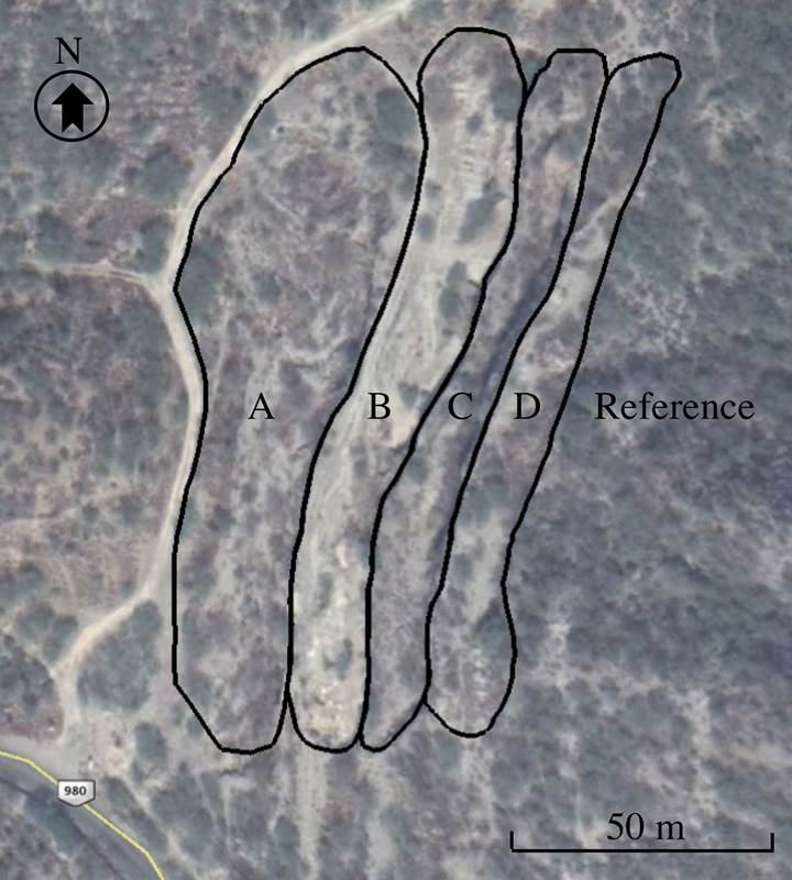
Figure 1 Aerial image of the sites A-D and the reference site in San Rafael Coxcatlán, Puebla, Mexico.
To evaluate spontaneous succession in each site, we selected nine indicators of ecosystem structure and function, namely, canopy cover, tree cover, shrub cover, herb cover, bare ground cover, litter cover, biocrust cover, visual obstruction, and soil surface in canopy gaps (Pellant et al. 2005). Canopy cover, shrub cover, biocrust cover, and bare ground cover provided information on the capacity of an area to limit the redistribution and loss of nutrients and organic matter from the soil (i.e., soil/site stability sensuHerrick et al. 2009, 2017). For instance, sites with high canopy cover, shrub cover, and biocrust cover and low bare ground cover have a high stability. Furthermore, litter cover, bare ground cover, and soil in canopy gaps are indicators of the capacity of an area to capture, store, and distribute rainfall and limit surface runoff (i.e., hydrologic function sensuHerrick et al. 2009, 2017). Sites with high litter cover as well as low bare ground cover and soil in canopy gaps have a high hydrologic function. Finally, tree cover, shrub cover, herb cover, litter cover, and visual obstruction provide information on the capacity of an area to sustain energy fluxes and nutrient cycling within the normal range of variability in that area (i.e., biotic integrity sensuHerrick et al. 2009, 2017). That is, sites with high plant cover, litter cover, and visual obstruction have a high integrity.
The nine indicators were calculated from data on vegetation and soil characteristics collected using the line-point intercept, vegetation structure, and gap intercept methods (Herrick et al. 2009, 2017). At each site, depending on the size of the area, we placed 3-4 parallel 30 m long measuring tapes on the ground surface, each separated by 10 m. The tapes were placed in the most representative areas of each site. With the line-point intercept method (Herrick et al. 2017), we placed a vertical 3 m pole every meter along the tape and recorded the plants and its growth form, litter, biocrust, and bare ground that were intercepted by the pole. The number of intercepts was used to calculate the percentage of canopy cover, tree cover, shrub cover, herb cover, litter cover, and bare ground cover. As for the vegetation structure method (Herrick et al. 2009), we placed a vertical 3 m pole (divided into 30 segments of 10 cm) at 5, 15, and 25 m along the tape and recorded the number of segments covered by vegetation. The segments were observed through a 140 cm sighting pole that was placed 5 m before and 5 m after the 3 m pole. The number of segments was used to calculate the percentage of visual obstruction. As for the gap intercept method (Herrick et al. 2017), we recorded the beginning and end points of gaps between plant canopies intersected by the tape. Gaps were classified into four categories: 0.5-1 m, 1-5 m, 5-10 m, and > 10 m. The sum of the lengths of the gaps in each category was used to calculate the percentage of soil surface in canopy gaps.
The indicators were then analyzed with a one-way analysis of variance and Dunnett’s multiple comparison test, in which each of the four sites was compared to the reference site, except for the canopy gaps. The gaps were analyzed with a nested analysis of variance, in which gaps were nested within sites, and Dunnett’s multiple comparison test. The indicators were arcsine-transformed to meet the normality and homoscedasticity assumptions of the statistical tests. The analyses were performed using JMP statistical software, version 14.3 (SAS 2018).
Results
Most indicators significantly differed between the degraded sites and the reference site (canopy cover: F4,12 = 4.57, P = 0.018; tree cover: F4,12 = 8.59, P = 0.002; shrub cover: F4,12 = 4.77, P = 0.016; bare ground cover: F4,12 = 3.40, P = 0.044; litter cover: F4,12 = 6.56, P = 0.005; visual obstruction: F4,12 = 12.62, P = 0.000), except for the herb cover (F4,12 = 1.67, P = 0.222), biocrust cover (F4,12 = 0.45, P = 0.991), and soil surface in canopy gaps (site: F4,41 = 0.12, P = 0.975; gap [site]: F12,41 = 1.05, P = 0.422). The canopy cover was significantly lower in site B (32 %) than in the reference site (80 %). The remaining degraded sites had higher cover values (57-76 %), which did not differ from that of the reference site (Table 1). Despite differences in the canopy cover, the tree cover was significantly lower in all the degraded sites (0-3 %) compared with the reference site (21 %). Moreover, the shrub cover was significantly lower in site B (8 %) than in the reference site (42 %). The three other sites had higher covers (51-52 %), which did not differ from that of the reference site. In contrast to the canopy and shrub covers, the bare ground cover was significantly higher in site B (14 %) than in the reference site (2 %), whereas the rest of the sites had lower cover values (2-3 %) and did not differ from the reference site. As for the litter cover, it was significantly lower in all the degraded sites (3-30 %) than in the reference site (77 %). Finally, visual obstruction was significantly lower in sites A, B, and C (6-25 %) than in site D (50 %) and the reference site (66 %). The differences between site D and the reference site were not significant (Table 1).
Table 1 Values of ecosystem structure and function indicators (mean ± standard error) for the sites A-D and the reference site. For each indicator, the means denoted by a different letter indicate significant differences from the reference site (P < 0.05).
| Indicator (%) | Site | |||||
|---|---|---|---|---|---|---|
| A | B | C | D | Reference | ||
| Canopy cover | 76 ± 8 a | 32 ± 8 b | 60 ± 5 a | 57 ± 15 a | 80 ± 8 a | |
| Tree cover | 2 ± 2 b | 0 ± 0 b | 3 ± 2 b | 2 ± 2 b | 21 ± 5 a | |
| Shrub cover | 52 ± 13 a | 8 ± 3 b | 51 ± 7 a | 51 ± 16 a | 42 ± 6 a | |
| Herb cover | 49 ± 11 | 20 ± 7 | 28 ± 8 | 41 ± 17 | 19 ± 3 | |
| Bare ground cover | 2 ± 1 a | 14 ± 3 b | 3 ± 2 a | 3 ± 3 a | 2 ± 2 a | |
| Litter cover | 27 ± 10 b | 3 ± 2 b | 19 ± 4 b | 30 ± 16 b | 77 ± 11 a | |
| Biocrust cover | 40 ± 16 | 51 ± 4 | 42 ± 7 | 21 ± 13 | 56 ± 14 | |
| Visual obstruction | 21 ± 3 b | 6 ± 3 b | 25 ± 1 b | 50 ± 15 a | 66 ± 5 a | |
| Soil surface in canopy gaps: | ||||||
| 0.5-1 m | 3 ± 1 | 1 ± 1 | 3 ± 3 | 1 ± 1 | 2 ± 1 | |
| 1-5 m | 22 ± 1 | 17 ± 15 | 22 ± 2 | 22 ± 13 | 22 ± 8 | |
| 5-10 m | 6 ± 6 | 16 ± 10 | 9 ± 9 | 14 ± 14 | 0 ± 0 | |
| >10 m | 0 ± 0 | 34 ± 24 | 14 ± 14 | 12 ± 12 | 0 ± 0 | |
Discussion
According to the hypothesis, several indicators in the degraded sites tended to be similar to those in the reference site. These results suggest that spontaneous succession partially restored vegetation structure and function of the sites degraded by gypsum quarrying in San Rafael Coxcatlán. However, this restoration approach was only evaluated in one site because the surface extension and management of the gypsum quarry did not allow us to replicate it. Despite this limitation, the differences found between the degraded and reference sites provided empirical evidence of the effectiveness of spontaneous succession to restore vegetation structure and function of sites degraded by quarrying.
In all the degraded sites, the herb cover and biocrust cover were similar to those in the reference site. These results are in line with those of previous studies, which reported the presence of herbs in abandoned mining sites restored through spontaneous succession, where they reached cover values of up to 60 % (Ninot et al. 2001), and of biocrust patches in rehabilitated mining areas (van der Walt et al. 2012). The biocrust cover especially fulfills a considerable function in degraded sites because biocrusts can increase the infiltration rate and improve soil stability. Biocrusts can also increase the content and availability of soil nutrients (Weber et al. 2016). Moreover, sites A, C, and D had values of canopy, shrub, and bare ground cover similar to those observed in the reference site. Other studies have also found that shrub cover increases in sites degraded by mining and agriculture, where vegetation succession occurs spontaneously (Burke 2014, Tabeni et al. 2016). The shrub cover significantly affects degraded sites because shrubs create fertility islands that can increase the infiltration rate, improve soil organic matter and nutrient content, and promote microbial activity (Maestre & Cortina 2004, Tabeni et al. 2016). Additionally, fertility islands can facilitate the seedling establishment of other plant species and provide refuge for animals (Tabeni et al. 2016). In contrast to sites A, C, and D, site B had lower canopy and shrub covers, but a higher bare ground cover, compared with the reference site. Another study has also reported a low vegetation cover and large bare ground patches in sites where vegetation succession had occurred spontaneously (Ninot et al. 2001). Since sites A and B experienced the same land management, except for the transit of garbage trucks, these trucks might be the cause of the low vegetation cover and high bare ground cover in site B. In site B, the vegetation probably provides low protection against rainfall and surface runoff and, consequently, against soil and nutrient loss. However, the recovery of this site could be promoted by inserting bush piles in bare ground areas to obstruct surface runoff and capture water, soil, and nutrients (Maestre & Cortina 2004). Furthermore, these piles would also provide suitable sites for plant establishment (Maestre & Cortina 2004). Lastly, all four degraded sites had tree cover, visual obstruction, and litter cover values lower than those of the reference site. This suggests that, in these sites, there are few trees to produce litter and contribute to nutrient cycling. The low tree cover in the degraded sites might be a consequence of trees being late successional species with poor dispersal abilities. However, the degraded sites were located at approximately 100 m from the site with natural vegetation, which might be a source of propagules. Thus, it is likely that trees will eventually recolonize these sites, and further monitoring should be performed to confirm this assertion.
We conclude that spontaneous vegetation succession after 40 years, partially restored the structure and function of degraded sites in our study. However, other stone quarrying sites and restoration practices such as reforestation with native plants should also be evaluated to further explore the implications of this approach.

